

Overview
Physical geography terms are the words that name the landforms, processes and patterns of the earth's natural environment. They span four linked spheres, namely the lithosphere of rocks and landforms, the atmosphere of weather and climate, the hydrosphere of oceans, rivers and ice, and the biosphere of soils, plants and animals. Each term is defined in one to three sentences and is grouped with the terms it is studied with, so that related or easily confused terms stand together, such as cirque, arête and horn among glacial landforms, or the doldrums, the horse latitudes and the subpolar low among pressure belts. Within each group the terms run from A to Z.
Interior of the Earth, Rocks and Plate Tectonics Terms
Earth's Layers, Discontinuities and Seismic Waves
- Asthenosphere: The weak, partly molten zone of the upper mantle that lies below the lithosphere and is thought to extend to about 400 km. It is the main source of the magma that reaches the surface during volcanic eruptions, and the rigid lithospheric plates move over it.
- Body waves: Earthquake waves that are generated at the focus and travel in all directions through the interior of the earth. They are of two kinds, P‑waves and S‑waves.
- Conrad discontinuity: A boundary within the continental crust, found at a depth of about 15 to 20 km in many continental regions, where the speed of seismic waves increases abruptly. It was once taken as the boundary between an upper granitic crust (sial) and a lower basaltic crust (sima), and it is absent under the oceans.
- Core: The innermost part of the earth, below the core-mantle boundary at a depth of 2,900 km. It is made mostly of nickel and iron, which is why it is sometimes called the nife layer.
- Crust: The outermost solid and brittle layer of the earth. Oceanic crust has a mean thickness of about 5 km and continental crust about 30 km, rising to as much as 70 km under the Himalaya.
- Earthquake: A shaking of the earth caused by the sudden release of energy, usually when the rocks on the two sides of a fault slip past each other. The energy travels outward from the focus as seismic waves.
- Epicentre: The point on the earth's surface directly above the focus of an earthquake. It is the first place on the surface to receive the earthquake waves.
- Focus: The point inside the earth where an earthquake originates and its energy is released; it is also called the hypocentre.
- Gutenberg discontinuity: The boundary between the lower mantle and the outer core at a depth of about 2,900 km. At this depth P‑waves slow down sharply and S‑waves disappear, which shows that the outer core is liquid.
- Hydrosphere: All the water of the earth, in the oceans, seas, rivers, lakes, groundwater, ice and the atmosphere.
- Inner core: The solid central part of the earth, made largely of iron and nickel. It stays solid despite its very high temperature because of the enormous pressure at that depth.
- Liquefaction: The loss of strength of water-saturated sand or silt during strong ground shaking, when the sediment behaves like a liquid. Buildings resting on such ground can tilt or sink.
- Lithosphere: The rigid outer shell of the earth made up of the crust and the uppermost part of the mantle, with a thickness ranging from about 10 to 200 km. It is broken into the plates of plate tectonics; the word is also used for the solid earth as a whole, as one of the four spheres.
- Magnitude: A measure of the energy released by an earthquake, calculated from the amplitude of the seismic waves recorded on seismographs. It is reported on a logarithmic scale such as the Richter scale or the moment magnitude scale.
- Mantle: The thick layer of the earth between the crust and the core, extending from the Moho to a depth of 2,900 km. Its upper part contains the asthenosphere, while the lower mantle is solid.
- Modified Mercalli intensity scale: A scale from I to XII that rates the intensity of an earthquake at a particular place by its observed effects on people, buildings and the ground. Unlike magnitude, intensity varies from place to place for the same earthquake.
- Moho: The boundary between the crust and the mantle, named the Mohorovičić discontinuity after the seismologist who identified it, where the speed of seismic waves increases sharply. Its depth follows the thickness of the crust, about 5 km below the ocean floor and about 30 km or more below the continents.
- Outer core: The liquid layer of the earth between the mantle and the inner core. The movement of its molten iron is believed to generate the earth's magnetic field.
- P‑waves: Primary waves, the fastest earthquake waves and the first to reach a seismograph. They make the particles of the material vibrate to and fro in the direction in which the wave travels, and they pass through solids, liquids and gases.
- Richter scale: The magnitude scale devised by Charles Richter in 1935 to measure the size of an earthquake from the amplitude of its waves. Each whole-number step means a tenfold increase in wave amplitude and about 31.6 times more energy released.
- Seismograph: An instrument that detects and records the vibrations of the ground caused by earthquakes. The record it produces is called a seismogram.
- Shadow zone: The area on the earth's surface where a seismograph does not record the direct waves of a particular earthquake. The P‑wave shadow zone is a band between 105° and 145° from the epicentre, while the S‑wave shadow zone covers everything beyond 105°, a little over 40 per cent of the earth's surface.
- Surface waves: Earthquake waves that form when body waves interact with surface rocks and then travel along the surface. They arrive last at a seismograph and cause the most damage.
- S‑waves: Secondary waves, which reach a seismograph after the P‑waves. They make particles vibrate at right angles to the direction of travel, creating crests and troughs, and they travel only through solid materials.
| Feature | Magnitude | Intensity |
|---|---|---|
| What it measures | Energy released at the source | Strength of shaking and damage at a place |
| Common scale | Richter scale or moment magnitude scale | Modified Mercalli intensity scale |
| Form of the scale | Logarithmic numbers | Roman numerals I to XII |
| Values for one earthquake | One value | Many values, falling with distance from the epicentre |
| Basis | Instrument readings of wave amplitude | Observed effects on people, buildings and ground |

Rocks, Minerals and Rock Structure Terms
- Basalt: A fine-grained, dark volcanic rock that forms when lava low in silica cools quickly at the surface. It makes up most of the ocean floor and the Deccan Traps.
- Bedding plane: The surface that separates one layer of sedimentary rock from the next. Rocks tend to split along these planes.
- Contact metamorphism: The change in rocks caused by the heat of magma that has intruded into them. It affects only a zone close to the contact with the magma.
- Extrusive igneous rock: Igneous rock formed when lava cools and solidifies on the earth's surface; it is also called volcanic rock. Rapid cooling gives it fine grains, as in basalt.
- Granite: The most common coarse-grained intrusive rock, formed when magma rich in silica cools slowly deep in the crust. It contains both light and dark minerals and forms the core of many batholiths.
- Hydrothermal metamorphism: The change in rocks caused by hot, mineral-rich water circulating through them. It is common near volcanic areas and mid-ocean ridges.
- Igneous rock: Rock formed by the cooling and solidification of magma or lava. It is called the primary rock because the other rock types are ultimately derived from it.
- Intrusive igneous rock: Igneous rock formed when magma cools and solidifies below the earth's surface; it is also called plutonic rock. Slow cooling gives it large crystals, as in granite.
- Joints: Cracks in a rock along which there has been no noticeable movement of the rock on either side. Large joints that run for long distances through a rock mass are called master joints.
- Lava: Molten rock material that comes out on to the earth's surface. The same material is called magma while it is still below the surface.
- Magma: Molten rock material below the earth's surface, a mixture of liquid, crystals and dissolved gases such as water vapour and carbon dioxide. When it reaches the surface it is called lava.
- Metamorphic rock: Rock formed when an existing rock is changed in form or mineral make-up by heat, pressure or hot fluids without melting. Marble formed from limestone and quartzite formed from sandstone are examples.
- Mineral: A naturally occurring inorganic solid with a definite chemical composition and an orderly internal structure of atoms. Rocks are made of one or more minerals.
- Outcrop: A place where the bedrock is exposed at the surface, not covered by soil or loose material.
- Quartzite: A hard metamorphic rock formed from sandstone, in which the quartz grains are fused together by heat and pressure.
- Regional metamorphism: The change in rocks over a large area caused by the high temperature and pressure that develop during mountain building, where plates collide or one plate sinks under another.
- Rock: A solid mass made of one mineral or, more commonly, an aggregate of several minerals. Rocks are grouped by origin into igneous, sedimentary and metamorphic rocks.
- Rock cycle: The continuous process by which rocks change from one type into another over geological time. Igneous rocks can be weathered into sediments that form sedimentary rocks, and both can be changed into metamorphic rocks or melted to form magma again.
- Sedimentary rock: Rock formed from fragments of other rocks, from the remains of plants and animals, or from chemical deposits that are laid down in layers and then compacted and cemented. Sandstone, shale and limestone are examples.
- Silicate minerals: The largest group of minerals, made of silicon and oxygen combined with other elements such as aluminium, iron and magnesium. They form most of the earth's crust.
- Strata: The distinct layers of sedimentary rock or sediment, each laid down at a different time. The singular is stratum.
Volcanoes and Intrusive Igneous Landforms
- Active volcano: A volcano that is erupting or has erupted in the recent past. Barren Island in the Andaman and Nicobar Islands is the only active volcano in India.
- Batholith: A large body of magma that has cooled deep in the crust, usually granitic and often covering a large area. It appears at the surface only after the overlying rocks are removed by denudation.
- Caldera: A large depression formed when a volcano collapses into its own emptied magma chamber after a very explosive eruption. The volcanoes that form calderas are the most explosive of the earth's volcanoes.
- Cinder cone: A small, steep, cone-shaped volcano built from loose fragments of lava, called cinders, thrown out from a single vent.
- Composite volcano: A tall, cone-shaped volcano built of alternating layers of lava and pyroclastic material, produced by cooler and more viscous lava than basalt; it is also called a stratovolcano. Its eruptions are often explosive, as at Mount Fuji in Japan and Mount St. Helens in the United States.
- Dyke: A wall-like sheet of igneous rock, also spelt dike, formed when magma rises through a crack and cools almost at right angles to the ground. Dykes in western Maharashtra are believed to have fed the eruptions that built the Deccan Traps.
- Flood basalt: A vast outpouring of very fluid basaltic lava from long fissures, spreading over thousands of square kilometres in thick layers. The Deccan Traps of India are a flood basalt province.
- Fumarole: A vent in a volcanic area from which steam and gases escape. The little water that seeps down into it is turned to steam by the heat below.
- Geyser: A hot spring that throws out hot water and steam into the air at intervals. Old Faithful, fed by the Yellowstone hot spot, is a well-known example.
- Hot spot: An area of volcanic activity within a plate, far from plate boundaries, fed by magma rising from deep in the mantle. As a plate moves over a fixed hot spot, a chain of volcanoes forms, such as the Hawaiian Islands.
- Hot spring: A spring of hot water that rises to the surface after groundwater has been heated by hot rocks or magma below.
- Hydrothermal activity: The release of hot water and steam at the surface in volcanic areas, mainly through hot springs, geysers and fumaroles.
- Igneous intrusion: A body of igneous rock formed when magma forces its way into existing rocks and cools below the surface. Batholiths, laccoliths, lopoliths, phacoliths, sills and dykes are intrusive forms.
- Laccolith: A large dome-shaped intrusive body with a level base, connected to the magma source below by a pipe-like conduit; it is also spelt lacolith. Many of the granite domes of the Karnataka plateau are laccoliths or batholiths.
- Lahar: A fast-moving mudflow of volcanic ash, rock fragments and water that rushes down the slopes of a volcano; it is also called a volcanic mudflow.
- Lava dome: A steep, rounded mound formed when very viscous lava is pushed up into the vent of a volcano and piles up around it; it is also called a plug dome.
- Lopolith: A saucer-shaped intrusive body that is concave upward, formed when magma spreads along a weak plane and sags in the middle; it is also spelt lapolith.
- Mantle plume: A column of hot rock rising from deep in the mantle towards the surface. Mantle plumes are believed to feed hot spots.
- Mid-ocean ridge volcano: A volcano along the central rift of a mid-ocean ridge, where frequent eruptions add new crust to the ocean floor.
- Pacific Ring of Fire: The belt of frequent volcanic eruptions and earthquakes that surrounds the Pacific Ocean, along its plate boundaries and subduction zones.
- Phacolith: A lens-shaped, wavy mass of intrusive rock found at the base of a syncline or the top of an anticline in folded rocks, with a conduit to a magma source below.
- Pluton: A general name for any body of intrusive igneous rock, large or small.
- Pyroclastic flow: A fast avalanche of hot gas, ash and rock fragments that rushes down the side of a volcano during an explosive eruption. It is also called a nuée ardente and is among the deadliest volcanic hazards.
- Pyroclastics: Fragments of rock and lava blown into the air by a volcanic eruption, ranging from fine ash and cinders to large volcanic bombs.
- Shield volcano: A broad volcano with gentle slopes, built by repeated outpourings of very fluid basaltic lava. Apart from flood basalts, shield volcanoes are the largest volcanoes on the earth; the Hawaiian volcanoes are the best-known examples.
- Sill: A nearly horizontal sheet of intrusive igneous rock formed when magma spreads along a bedding plane. A thin sill is called a sheet.
- Volcanic island arc: A curved chain of volcanic islands formed where one oceanic plate sinks below another, such as the Aleutian Islands and the Marianas.
- Volcanism: All the processes by which magma and its gases move from the interior of the earth to or near the surface.
- Volcano: An opening in the earth's crust through which gases, ash and molten rock escape to the surface, and the landform built around it by the material thrown out.
Continental Drift, Plate Boundaries and Earth Movements
- Continental drift: The theory put forward by the German meteorologist Alfred Wegener in 1912 that all the continents were once joined in a single landmass, Pangaea, which broke up and whose parts drifted to their present positions.
- Continental rift valley: A long valley formed where a continent is being stretched and pulled apart, with blocks of crust sinking between faults. The East African Rift, where the African plate is splitting into the Nubian and Somali plates, is the classic example.
- Convection cell: A closed loop of circulation in a fluid, in which heated material rises, spreads, cools and sinks. Convection cells in the mantle were proposed as the force that moves the plates, and convection cells in the atmosphere set the pattern of planetary winds.
- Convergent boundary: A plate boundary where two plates move towards each other, so that one plate sinks under the other or the two collide. It is also called a destructive boundary.
- Diastrophism: All the processes that move, raise or build up parts of the earth's crust, including folding, faulting, orogeny and epeirogeny.
- Divergent boundary: A plate boundary where two plates move apart and new crust is created by magma rising between them, as along the mid-ocean ridges. It is also called a constructive boundary.
- Endogenic processes: Processes driven by energy from inside the earth, such as diastrophism and volcanism, which build up and raise parts of the surface; they are also called internal processes.
- Epeirogeny: The slow uplift or sinking of large parts of the earth's crust with little folding.
- Eustatic sea-level change: A worldwide rise or fall of sea level caused by a change in the volume of water in the oceans, as when ice sheets grow or melt.
- Gondwanaland: The southern part of Pangaea, made up of the present South America, Africa, Madagascar, Peninsular India, Australia and Antarctica.
- Isostasy: The state of balance in which the blocks of the earth's crust float on the denser mantle, with high mountains supported by deep roots of lighter rock. Where weight is added, as by an ice sheet, the crust sinks, and where weight is removed it slowly rises.
- Laurasia: The northern part of Pangaea, made up of the present North America, Europe and most of Asia.
- Mid-ocean ridge: A long chain of underwater mountains along a divergent plate boundary, with a rift at its crest where new ocean floor forms. The system is more than 70,000 km long and runs through all the ocean basins, and in places its peaks rise above the sea, as Iceland does on the Mid-Atlantic Ridge.
- Oceanic trench: A long, narrow and very deep depression in the ocean floor, formed where one plate sinks below another. Trenches are the deepest parts of the oceans.
- Orogeny: The process of mountain building, in which the crust is severely folded and deformed, usually where plates converge.
- Paleomagnetism: The record of the earth's past magnetic field preserved in rocks, especially in iron minerals that lined up with the field as lava cooled. Stripes of normal and reversed magnetism on either side of mid-ocean ridges gave strong evidence for sea floor spreading.
- Pangaea: The single supercontinent that, in Wegener's theory, joined all the present continents. It began to break up about 200 million years ago.
- Panthalassa: The single vast ocean that surrounded Pangaea.
- Plate tectonics: The theory that the lithosphere is broken into large rigid plates that move over the asthenosphere, and that earthquakes, volcanoes and mountain belts are concentrated along the boundaries of these plates.
- Sea floor spreading: The process, proposed by Harry Hess in 1961, by which new oceanic crust forms at mid-ocean ridges as magma rises and the plates on either side move apart. The ocean floor is therefore youngest at the ridges and older away from them.
- Subduction: The sinking of the edge of one plate, usually oceanic, below another plate into the mantle at a convergent boundary.
- Transform boundary: A plate boundary where two plates slide past each other horizontally, so that crust is neither created nor destroyed. It is also called a conservative boundary, and the San Andreas fault zone in California is an example on land.
- Uniformitarianism: The principle that the processes acting on the earth today also acted in the past, so that the present is the key to understanding the past.
Folds, Faults and Tectonic Landforms
- Anticline: An upward fold in layers of rock, shaped like an arch, with the oldest rocks at its core.
- Fault: A fracture in the earth's crust along which the rocks on one side have moved relative to those on the other side. The movement may be vertical, horizontal or both.
- Fault scarp: A steep slope or cliff formed by movement along a fault.
- Fault-block mountain: A mountain formed when a block of crust is raised or tilted between faults. A tilted block has a steep side along the fault scarp and a gentle slope on the other side.
- Folding: The bending of layers of rock into waves by compression in the crust. Fold mountains such as the Himalaya and the Alps were formed in this way.
- Graben: A long block of crust that has dropped down between two roughly parallel faults, forming a rift valley.
- Horst: A block of crust that stands raised between two roughly parallel faults.
- Linear fault trough: A straight valley that marks the line of a fault, formed by the erosion of crushed rock along it.
- Normal fault: A fault formed by tension in the crust, in which the block above the fault plane slides down relative to the block below.
- Offset stream: A stream whose course is displaced sideways where it crosses a fault on which the blocks have moved horizontally.
- Plateau: An extensive area of flat or gently rolling high land that rises steeply above the land around it on at least one side. The Deccan Plateau is an example.
- Reverse fault: A fault formed by compression in the crust, in which the block above the fault plane is pushed up over the block below. A low-angle reverse fault is called a thrust fault.
- Sag pond: A pond that forms in a hollow along a fault line, where crushed rock has sunk and water from springs or runoff collects.
- Strike-slip fault: A fault along which the blocks move horizontally past each other with little vertical movement.
- Syncline: A downward fold in layers of rock, shaped like a trough, with the youngest rocks at its core.
Geomorphic Processes and Landform Terms
Weathering, Mass Movement and Denudation
- Aggradation: The building up of the land surface by the deposition of sediment, as when a river raises its bed by laying down its load.
- Angle of repose: The steepest angle at which loose material such as sand or scree can rest on a slope without sliding down.
- Biological weathering: The breaking down of rocks by living things, as when plant roots widen cracks, burrowing animals expose fresh rock and the decay of organic matter releases acids.
- Carbonation: A chemical weathering process in which carbon dioxide dissolved in water forms a weak carbonic acid that dissolves carbonate rocks such as limestone. It is the main process behind karst landforms.
- Chemical weathering: The decomposition of rocks by chemical reactions that change their minerals, through solution, carbonation, hydration, oxidation and reduction. It is most active where it is hot and wet.
- Creep: The slowest form of mass movement, in which soil and loose rock move downslope so gradually that the movement is seen only over long periods, through tilted posts and bent tree trunks.
- Debris flow: A rapid flow of water mixed with a large amount of soil, rock fragments and boulders down a steep slope or channel.
- Degradation: The lowering of the land surface by erosion. Together with aggradation it makes up gradation, the levelling of the earth's surface.
- Denudation: The general term for all the exogenic processes, namely weathering, mass movement, erosion and transportation, that strip off and wear down the earth's surface.
- Deposition: The laying down of material carried by running water, glaciers, wind, waves or groundwater, when the agent loses the energy to carry it.
- Differential weathering: The wearing away of different rocks, or different parts of the same rock, at different rates, which leaves the more resistant rock standing out.
- Dissolution: A chemical weathering process in which water dissolves soluble minerals and carries them away in solution; it is also called solution.
- Earthflow: A downslope movement of water-saturated soil and weathered material, usually over a short distance on a moderate slope.
- Erosion: The removal and transport of weathered rock material by moving agents such as running water, glaciers, wind, waves and groundwater. Weathering prepares the material and erosion carries it away.
- Exfoliation: The peeling off of curved sheets or shells of rock from the surface of a rock mass, which leaves smooth rounded surfaces. It results from unloading, from repeated heating and cooling, and from salt weathering.
- Exfoliation dome: A large rounded mass of bare rock, usually granite, whose surface is made of curved shells loosened by exfoliation.
- Exogenic processes: Processes driven by energy from outside the earth's crust, chiefly the sun and gravity, acting through weathering, mass movement, erosion and deposition. They are also called external processes, and they wear down the relief built up by endogenic processes.
- Fall: A rapid mass movement in which rock fragments drop freely from a cliff or steep slope; it is also called rockfall.
- Fluvial processes: The erosion, transport and deposition carried out by running water.
- Frost wedging: The splitting of rock when water in its cracks freezes and expands, forcing the cracks wider over repeated cycles of freezing and thawing.
- Geomorphic agent: A mobile medium, such as running water, a glacier, wind, waves or groundwater, that erodes, transports and deposits earth materials.
- Geomorphology: The study of landforms, their origin and their evolution, and of the processes that shape them.
- Hydration: A chemical weathering process in which minerals take up water and expand, which weakens the rock.
- Hydrolysis: A chemical reaction between water and the minerals of a rock that forms new, usually softer, minerals such as clays.
- Landform: A natural feature of the earth's surface with a characteristic shape, such as a hill, valley, plain or plateau, formed by geomorphic processes.
- Landslide: A rapid movement of a large mass of rock or soil down a slope along a surface of failure, often triggered by heavy rain, earthquakes or the undercutting of slopes.
- Mass movement: The downslope movement of rock and soil under the direct pull of gravity, without a carrying agent such as water or ice; it is also called mass wasting. It ranges from slow creep to sudden landslides.
- Mechanical weathering: The breaking down of rocks into smaller pieces without any change in their chemical composition, through unloading, temperature changes, frost and salt crystal growth; it is also called physical weathering.
- Mudflow: A rapid flow of fine weathered material mixed with water, usually down a valley after heavy rain.
- Oxidation: A chemical weathering process in which oxygen combines with minerals, especially those containing iron, giving rocks a red, brown or yellow colour and making them crumble.
- Regolith: The layer of loose, broken and weathered rock material that covers the solid bedrock.
- Salt wedging: The breaking of rock when salt crystals grow in its pores and cracks as salty water evaporates. It is common in deserts and on coasts.
- Scree: A heap of angular rock fragments that collects at the foot of a cliff or steep slope after falling from above; it is also called talus.
- Sediment: Particles of rock, mineral or organic matter carried and laid down by water, wind or ice.
- Slump: A landslide in which a block of rock or soil slides down along a curved surface and rotates backwards as it moves.
- Solifluction: The slow downslope flow of water-saturated soil over frozen ground, common in cold regions where the upper layer thaws in summer while the ground below stays frozen.
- Weathering: The mechanical disintegration and chemical decomposition of rocks in place, through the action of the elements of weather and climate. It is the first step in soil formation and in erosion.
| Process | What happens | Is material moved? | Main driver |
|---|---|---|---|
| Weathering | Rock breaks up or decomposes | No, it stays in place | Weather, water and living things |
| Mass movement | Rock and soil move downslope | Yes, over short distances | Gravity alone |
| Erosion | Weathered material is picked up and carried | Yes, often over long distances | Running water, ice, wind, waves |
Rivers, Drainage Basins and Stream Behaviour
- Antecedent stream: A river that existed before the uplift of the land across its course and kept cutting down its valley as the land rose, forming a deep gorge. The Sutlej, which crosses the Himalaya through the Shipki La, is an antecedent river.
- Base level: The lowest level to which a stream can erode its bed, which for most rivers is sea level.
- Bedload: The coarse sand, gravel and boulders that a stream rolls, slides or bounces along its bed.
- Braided channel: A river channel divided into many shallow, interlacing channels separated by bars of sand and gravel. It forms where a river carries more load than it can move, as on the Brahmaputra plains.
- Capacity: The total amount of load a stream can carry at a given time, which rises with its volume and speed.
- Competence: The size of the largest particle a stream can move, which rises steeply with the stream's speed.
- Consequent stream: A stream that follows the original slope of the land.
- Dendritic drainage: A drainage pattern shaped like the branches of a tree, in which tributaries join larger streams at acute angles. It develops on rocks of uniform resistance.
- Disappearing stream: A stream that suddenly vanishes underground into a swallow hole or cave, common in limestone areas.
- Dissolved load: The minerals that a stream carries in solution, invisible in the water.
- Downcutting: The deepening of a river valley by vertical erosion of the bed, strongest where the gradient is steep and the flow fast.
- Drainage basin: The area drained by a river and its tributaries, from which all surface water flows to the same outlet; it is also called a catchment or a river basin.
- Drainage divide: The line of high ground that separates neighbouring drainage basins; it is also called a water divide or watershed.
- Ephemeral stream: A stream that flows only during and just after rain.
- Exotic stream: A river that flows through a dry region with water that comes from a wetter region elsewhere, as the Indus does through its desert lower course.
- Gradient: The slope of a stream bed, the fall in height over a given distance.
- Headward erosion: The lengthening of a valley upstream as its head is worn back by running water.
- Interfluve: The higher ground between two neighbouring valleys.
- Intermittent stream: A stream that flows for part of the year, usually during the wet season, and dries up for the rest.
- Knickpoint: A sudden break of slope in a river's long profile, often marked by a waterfall or rapids, that slowly moves upstream as it is eroded.
- Lake: A body of water lying in a basin on land, which rivers may feed or drain.
- Lateral erosion: The sideways erosion of a river bank, strongest on the outer bank of a bend, which widens the valley.
- Meandering channel: A river channel that winds in a series of loops, typical of a gentle gradient on a floodplain.
- Overland flow: Water that flows over the ground surface as a thin sheet before it gathers into channels.
- Perennial stream: A stream that flows throughout the year. Most Himalayan rivers are perennial because they are fed by both rain and melting snow.
- Radial drainage: A pattern in which streams flow outward in all directions from a central high point such as a volcanic cone or dome.
- Recurrence interval: The average length of time between floods of a given size or larger at a place; it is also called the return period. A flood with a recurrence interval of 100 years has a 1 in 100 chance of happening in any one year, so the probability is the reciprocal of the interval.
- Rejuvenation: The renewed power of a river to erode its bed, usually after uplift of the land or a fall in sea level.
- Runoff: The part of precipitation that flows over the land surface and through streams towards the sea.
- Sinuous channel: A river channel that bends gently, between a straight channel and a fully meandering one.
- Stream: Any body of water flowing in a channel, whatever its size; the movement of its water along the channel is called streamflow.
- Stream capture: The diversion of the headwaters of one stream into another stream that has cut back into its basin by headward erosion; it is also called river piracy.
- Stream load: All the material a stream carries, made up of the bedload, the suspended load and the dissolved load.
- Stream order: A ranking of streams in a drainage network, in which the smallest headwater streams are first order and two streams of the same order join to form a stream of the next order.
- Superimposed stream: A river that formed on a cover of younger rocks and kept its course while cutting down into the older, differently structured rocks below.
- Suspended load: The fine clay and silt carried along within the water without touching the bed.
- Trellis drainage: A drainage pattern in which tributaries join the main stream at nearly right angles, typical of folded areas with alternating bands of hard and soft rock.
- Yazoo stream: A tributary that runs parallel to the main river for a long distance because the main river's natural levees stop it from joining.
Fluvial Landforms from Gorges to Deltas
- Alluvial fan: A fan-shaped deposit of sediment laid down where a stream flows out of a mountain onto a plain and suddenly loses speed.
- Alluvium: Sand, silt, clay and gravel deposited by running water.
- Badlands: A landscape of steep, bare slopes cut into countless gullies and ravines by running water in soft rocks of dry regions. The ravines of the Chambal valley are an example.
- Bajada: A continuous apron of sediment at the foot of a mountain range in a desert, formed where several alluvial fans join.
- Canyon: A deep river valley with steep, step-like side slopes, wider at its top than at its bottom; it is a variant of the gorge.
- Cut-off meander: A loop of a meandering river that has been abandoned after the river cut across its narrow neck.
- Delta: A low, usually triangular landform built at the mouth of a river where it deposits its load on entering a sea or lake.
- Entrenched meander: A meander cut deep into the rock, formed when a meandering river is rejuvenated and cuts downward while keeping its winding course; it is also called an incised meander.
- Estuary: The tidal mouth of a river, where fresh water mixes with sea water and the river does not build a delta. The Narmada meets the Arabian Sea south of Bharuch in a broad estuary about 27 km long.
- Floodplain: The flat land along a river that is built of alluvium and is covered by water when the river floods.
- Gorge: A deep river valley with very steep to straight sides, almost equal in width at its top and its bottom.
- Meander: A loop-like bend in a river channel, with erosion on the outer bank and deposition on the inner bank.
- Meander scar: A dry, curved hollow on a floodplain that marks a former meander of the river.
- Natural levee: A low ridge of coarse alluvium along the banks of a river, built up when floodwater spills over and drops its load next to the channel.
- Oxbow lake: A curved lake formed when a meander is cut off from the main river and its ends are sealed by deposits.
- Peneplain: A low, almost featureless plain produced at the end of a long cycle of erosion by running water, with a few resistant hills, called monadnocks, standing out.
- Piedmont zone: The area at the foot of a mountain range.
- Plunge pool: A deep hollow at the foot of a waterfall, scoured by the falling water and the rocks it swirls round.
- Point bar: A crescent-shaped deposit of sand and gravel on the inner bank of a meander, where the water flows slowest.
- Pothole: A round hollow drilled into a rocky river bed by pebbles swirled around by eddies.
- River terrace: A step-like bench on the side of a river valley, the remnant of an older floodplain left above the river after it cut down; it is also called a stream terrace.
- Valley: A long, low area of land between hills or mountains, usually with a river flowing through it. River valleys are V‑shaped in their young stage and glacial valleys are U‑shaped.
- Waterfall: A sudden drop in a river's course over a vertical or very steep step, often where hard rock overlies soft rock.
Groundwater, Aquifers and Karst Topography
- Aquiclude: A layer of rock, such as clay or shale, that is so impermeable that water cannot pass through it.
- Aquifer: A layer of permeable rock or sediment that can store water and let it flow, so that it supplies wells and springs.
- Artesian well: A well drilled into a confined aquifer in which the water rises to the surface by its own pressure, without pumping.
- Capillarity: The rise of water through tiny spaces in soil or rock against the pull of gravity, because water molecules cling to each other and to the grains.
- Cavern: A large cave formed by the dissolving of limestone by groundwater.
- Cone of depression: The cone-shaped lowering of the water table around a well from which water is pumped faster than the aquifer can refill it.
- Groundwater: Water held below the ground surface in the pores and cracks of soil and rock, especially in the zone of saturation.
- Karst: The landscape that develops on limestone and dolomite, where water dissolves the rock and drains underground, producing sinkholes, caves and few surface streams. The name comes from the Karst region next to the Adriatic Sea.
- Lapies: Grooves and ridges on a limestone surface formed by solution along joints; where they are widespread they form a limestone pavement.
- Permeability: The ability of a rock or soil to let water pass through it, which depends on its pores and cracks being connected.
- Piezometric surface: The level to which water from a confined aquifer would rise in a well under its own pressure.
- Porosity: The share of a rock's or soil's volume taken up by pore spaces, which decides how much water it can hold.
- Sinkhole: A funnel-shaped hollow on a limestone surface, formed by solution or by the collapse of a cave roof. One formed by collapse is a collapse sink, sometimes called a doline.
- Speleothem: Any deposit of calcium carbonate formed in a cave by dripping or flowing water, such as stalactites, stalagmites and pillars.
- Stalactite: An icicle-shaped deposit of calcium carbonate hanging from the roof of a cave. Where it meets a stalagmite growing from the floor, the two form a pillar.
- Stalagmite: A column of calcium carbonate that rises from the floor of a cave, built up by water dripping from the roof.
- Swallow hole: A small shallow hollow on a limestone surface through which surface water drains underground.
- Uvala: A large hollow formed when several sinkholes merge.
- Water table: The upper surface of the zone of saturation in the ground, below which all pores are filled with water.
- Zone of aeration: The layer of soil and rock above the water table, in which the pores hold both air and water; it is also called the vadose zone.
- Zone of confined water: The deeper layer in which an aquifer lies between impermeable layers, so that its water is held under pressure.
- Zone of saturation: The layer below the water table in which all the pores and cracks in the rock are filled with water; it is also called the phreatic zone.
Glaciers, Glacial Landforms and Periglacial Terms
- Ablation: The loss of ice and snow from a glacier by melting, evaporation, sublimation and the breaking off of icebergs.
- Ablation zone: The lower part of a glacier, where more ice is lost each year than is gained.
- Accumulation: The addition of snow and ice to a glacier, chiefly by snowfall, which is compacted into ice over the years.
- Accumulation zone: The upper part of a glacier, where more snow is added each year than is lost, so that it builds up and turns into ice.
- Arête: A narrow, sharp-edged rock ridge between two cirques that have been cut back from opposite sides.
- Basal slip: The sliding of a glacier over its bed on a thin film of meltwater.
- Cirque: A deep, armchair-shaped hollow at the head of a glacial valley, cut by ice and frost; after the ice melts it often holds a small lake called a tarn.
- Cirque glacier: A small glacier that stays within its cirque and does not flow far down the valley.
- Col: A low pass across a ridge, formed where two cirques on opposite sides have cut back far enough to break through the arête.
- Continental ice sheet: A vast sheet of ice covering a large part of a continent, as in Antarctica and Greenland today.
- Cryosphere: All the frozen water of the earth's surface, including snow cover, glaciers, ice sheets, sea ice, lake and river ice and frozen ground.
- Drift: All the material carried and deposited by glaciers and their meltwater.
- Drumlin: A smooth, oval hill of glacial till shaped like an inverted spoon, with its blunt end facing the direction from which the ice came.
- Equilibrium line: The line on a glacier separating the accumulation zone from the ablation zone, where the yearly gain of ice equals the yearly loss.
- Esker: A long, winding ridge of sand and gravel deposited by a meltwater stream that flowed in a tunnel under a glacier.
- Firn: Granular snow that has survived at least one melt season and is being compacted into glacier ice; it is also called névé.
- Fjord: A long, deep and narrow arm of the sea in a glacial trough that was drowned when sea level rose.
- Glacial erratic: A boulder carried by a glacier far from its source and left on rock of a different kind.
- Glacial flour: Rock ground to a very fine powder by a glacier, which gives meltwater streams their milky colour.
- Glacial plucking: The process by which a glacier freezes on to blocks of bedrock and pulls them away as it moves; it is also called quarrying.
- Glacial steps: A series of flat or gently sloping rock benches separated by steep drops along the floor of a glacial trough.
- Glacial trough: A deep, U‑shaped valley formed when a glacier widens and deepens a river valley.
- Glacier: A mass of ice formed from compacted snow that moves slowly downslope or outward under its own weight.
- Glaciofluvial deposit: Sediment laid down by meltwater streams flowing from a glacier, sorted into layers by the water.
- Ground moraine: A sheet of till left over a wide area beneath a glacier or ice sheet.
- Hanging valley: A tributary valley whose floor is high above the floor of the main glacial trough it joins, often with a waterfall at its mouth.
- Highland ice field: A sheet of ice covering a high mountain area, from which valley glaciers flow outward.
- Horn: A sharp, pyramid-shaped peak formed where three or more cirques are cut back into a mountain from different sides. The Matterhorn in the Alps and Mount Everest in the Himalaya are horns.
- Ice floe: A large, flat sheet of floating sea ice.
- Ice pack: A large expanse of sea ice made of floes frozen together, as in the Arctic Ocean and around Antarctica; it is also called pack ice.
- Ice shelf: A thick floating sheet of ice joined to the land, formed where a glacier or ice sheet flows out over the sea.
- Iceberg: A large mass of ice that has broken off a glacier or ice shelf and floats in the sea.
- Kettle: A hollow in glacial deposits left when a buried block of ice melts; filled with water, it forms a kettle lake.
- Lateral moraine: A ridge of debris deposited along the side of a valley glacier.
- Medial moraine: A ridge of debris running down the middle of a glacier, formed where the lateral moraines of two joining glaciers merge.
- Moraine: Any ridge or sheet of unsorted debris deposited directly by a glacier.
- Outwash plain: A broad plain of sand and gravel laid down by meltwater streams beyond the edge of a glacier or ice sheet.
- Paternoster lakes: A chain of small lakes along the floor of a glacial trough, like beads on a string.
- Patterned ground: Regular polygons, circles or stripes of stones formed on the ground surface by repeated freezing and thawing in cold regions.
- Periglacial zone: An area near the edge of glaciers or ice sheets, or with a very cold climate, where frost action and frozen ground shape the land.
- Permafrost: Ground that stays at or below 0°C for at least two years in a row.
- Plastic flow: The slow, deforming movement of ice deep inside a glacier under the pressure of the ice above, which makes the glacier flow like a very thick liquid.
- Pleistocene: The geological epoch of repeated glaciations, from about 2.58 million to about 11,700 years ago, commonly called the Ice Age.
- Pluvial: Of or caused by rain; the word describes past periods of heavier rainfall, during which large pluvial lakes filled basins of inland drainage that are dry today.
- Proglacial lake: A lake dammed by the front of a glacier or ice sheet, or by its moraine.
- Recessional moraine: A ridge of debris left where the front of a retreating glacier halted for a time.
- Roche moutonnée: A rock knob shaped by a glacier, smooth and gently sloping on the side from which the ice came and steep and rough on the downstream side, where blocks were plucked away.
- Rock glacier: A tongue of angular rock debris, held together by ice, that moves slowly downslope.
- Stratified drift: Glacial material that has been sorted and laid down in layers by meltwater.
- Terminal moraine: A ridge of debris marking the farthest point reached by a glacier.
- Till: Unsorted debris, from clay to boulders, deposited directly by melting ice.
- Valley glacier: A glacier that flows down a mountain valley like a river of ice; it is also called an alpine glacier.
- Valley train: A long deposit of sand and gravel laid down by meltwater along the floor of a valley below a glacier.

Desert Processes and Aeolian Landforms
- Abrasion: The wearing away of rock by sand and other fragments carried by wind, water or ice, which act like sandpaper.
- Aeolian processes: Processes caused by the work of wind, such as deflation, abrasion and the deposition of sand and dust. They are strongest in dry regions with little vegetation.
- Barchan: A crescent-shaped sand dune whose horns point downwind, formed where the wind blows steadily from one direction and sand is limited.
- Blowout: A shallow hollow formed where wind has removed loose sand and dust; it is also called a deflation hollow.
- Butte: A small, isolated, flat-topped hill with steep sides, left when a mesa is worn down.
- Deflation: The lifting and removal of loose dust and sand by wind.
- Desert: A region that receives very little precipitation and has sparse vegetation; the word also names the climate and the biome of such regions.
- Desert pavement: A surface of closely packed pebbles left on the ground after wind has removed the finer particles.
- Desert varnish: A thin dark coating of iron and manganese oxides on rock surfaces exposed for a long time in a desert.
- Erg: A large area of desert covered with shifting sand dunes; it is also called a sand sea.
- Hamada: A rocky desert surface of bare bedrock from which the wind has swept the loose material.
- Inselberg: An isolated, steep-sided rocky hill rising abruptly from a plain in a dry region.
- Loess: A thick deposit of fine, wind-blown silt that can stand in vertical cliffs.
- Longitudinal dune: A long ridge of sand of considerable length but low height, formed where the supply of sand is poor and the wind direction constant.
- Mesa: A flat-topped hill or plateau with steep sides, protected from erosion by a cap of hard rock.
- Mushroom rock: A rock shaped like a mushroom, with a slender stalk and a broad cap, formed where wind-blown sand wears away the base of a rock faster than its top.
- Pediment: A gently sloping rock surface at the foot of a mountain in a dry region, with or without a thin cover of debris.
- Pediplain: A wide plain formed in a desert when pediments extend and join as the mountains retreat.
- Pinnacle: A tall, slender spire of rock left standing by erosion, usually protected by a cap of resistant rock in a dry region.
- Playa: A flat, dry lake bed in a desert basin with inland drainage, which fills with water only after rain.
- Reg: A stony desert surface covered with gravel and pebbles.
- Salina: A dry lake bed with a heavy crust of salt; a basin of this kind that holds water is a saline lake.
- Sand dune: A mound or ridge of loose sand heaped up by the wind.
- Seif: A dune similar to a barchan but with only one wing, formed when the wind shifts; its lone wing can grow very long and high.
- Slip face: The steep downwind side of a sand dune, down which sand slides.
- Star dune: A pyramid-shaped dune with arms radiating in three or more directions, formed where winds blow from several directions.
- Ventifact: A stone with flat, polished faces cut by wind-blown sand.
Waves, Coastal Landforms and Coral Reefs
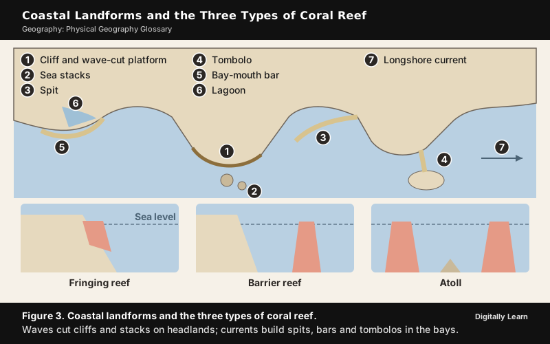
- Atoll: A ring-shaped coral reef enclosing a lagoon, formed when a fringing reef keeps growing upward around a volcanic island that sinks below sea level. Most of the Lakshadweep Islands are atolls.
- Backwash: The flow of water back down a beach after a wave has broken.
- Barrier island: A long, narrow island of sand lying parallel to the coast and separated from it by a lagoon.
- Barrier reef: A coral reef lying parallel to the coast at some distance from it, separated by a lagoon of open, often deep, water.
- Bay-mouth bar: A bar of sand or shingle that grows across the mouth of a bay and may close it off as a lagoon.
- Beach: A deposit of sand or pebbles along the shore between the low-tide line and the limit reached by storm waves.
- Beach drifting: The zigzag movement of sand and pebbles along a beach, where waves arrive at an angle and the backwash runs straight down the slope.
- Cliff: A steep rock face along the coast, formed where waves erode the base of the land.
- Fringing reef: A coral reef that grows outward directly from the shore of a mainland or island, with little or no lagoon. It is the most common type of coral reef.
- Groyne: A low wall, also spelt groin, built out from the shore at right angles to trap sand moving along the beach.
- Jetty: A wall built out into the sea at the mouth of a river or harbour to protect it from waves and the build-up of sediment.
- Lagoon: A shallow body of salt or brackish water separated from the sea by a bar, a barrier island or a reef.
- Longshore current: A current that flows parallel to the shore, created where waves approach at an angle; it carries sand along the coast.
- Marine terrace: A wave-cut platform that has been raised above the present sea level.
- Ria coast: A coast where river valleys have been drowned by a rise in sea level, giving many long inlets.
- Sea arch: A natural arch of rock formed where caves on both sides of a headland are eroded through.
- Sea cave: A hollow cut by waves into a weak part of a cliff.
- Sea stack: A pillar of rock standing in the sea, left when the top of a sea arch collapses.
- Sediment budget: The balance between the sediment added to a stretch of coast and the sediment carried away from it, which decides whether a beach grows or shrinks.
- Spit: A long ridge of sand or shingle attached to the land at one end and extending into the sea.
- Swash: The rush of water up a beach after a wave breaks.
- Tombolo: A bar of sand or shingle that joins an island to the mainland or to another island.
- Wave refraction: The bending of waves as they enter shallow water near the coast, so that they break almost parallel to the shore and concentrate their energy on headlands.
- Wave-cut platform: A gently sloping rock platform at the foot of a sea cliff, cut by waves as the cliff retreats.
Atmosphere, Weather and Climate Terms
Composition and Layers of the Atmosphere
- Acid rain: Rain, snow or fog made more acidic than normal by sulphur dioxide and nitrogen oxides from burning fuels, which dissolve in water in the air to form acids.
- Aerosols: Tiny solid or liquid particles suspended in the air, such as dust, smoke, sea salt, pollen and soot; they are also called particulates. They act as nuclei for condensation and affect how much sunlight reaches the ground.
- Atmosphere: The envelope of gases, water vapour and dust particles that surrounds the earth and is held by gravity. About 99 per cent of its mass lies within 32 km of the surface.
- Carbon dioxide: A gas that forms a small but important part of the atmosphere. It lets incoming solar radiation pass but absorbs outgoing terrestrial radiation, so it is a major greenhouse gas, and its amount has been rising mainly because of the burning of fossil fuels.
- Chlorofluorocarbons: Man-made compounds of chlorine, fluorine and carbon, once widely used in refrigerators and aerosol sprays, that destroy ozone in the stratosphere; they are known as CFCs.
- Exosphere: The uppermost layer of the atmosphere, above the thermosphere, where the air is extremely thin and gradually merges into outer space.
- Ionosphere: The part of the thermosphere between about 80 and 400 km that contains electrically charged particles called ions. It reflects radio waves sent from the earth back to the ground, which makes long-distance radio communication possible.
- Mesosphere: The layer of the atmosphere above the stratosphere, extending to about 80 km, in which temperature falls with height to about minus 100°C. Its upper limit is the mesopause.
- Ozone: A form of oxygen whose molecules have three atoms (O3). In the atmosphere it is found mainly between 10 and 50 km above the surface, where it absorbs the sun's ultraviolet rays.
- Ozone layer: The part of the stratosphere where ozone is most concentrated. It shields life on the earth from harmful ultraviolet radiation.
- Photochemical smog: A brown haze formed when sunlight acts on nitrogen oxides and hydrocarbons released mainly by vehicles, producing ozone and other harmful gases near the ground. It is a secondary pollutant.
- Primary pollutant: A pollutant released directly into the air from its source, such as sulphur dioxide from a power plant or carbon monoxide from a vehicle.
- Secondary pollutant: A pollutant formed in the air by chemical reactions among primary pollutants, such as ground-level ozone in photochemical smog.
- Stratosphere: The layer of the atmosphere above the tropopause, extending to about 50 km, which contains the ozone layer. Its temperature rises with height, and its calm, cloud-free air suits jet aircraft.
- Thermosphere: The layer of the atmosphere above the mesopause in which temperature rises sharply with height; it includes the ionosphere.
- Tropopause: The boundary zone between the troposphere and the stratosphere, where the temperature stays nearly constant. Its temperature is about minus 80°C over the equator and about minus 45°C over the poles.
- Troposphere: The lowest layer of the atmosphere, about 13 km thick on average, extending to about 8 km near the poles and about 18 km at the equator. It holds almost all the water vapour and dust, so all weather happens in it, and temperature falls with height through it.
- Water vapour: Water in the form of a gas. It makes up from almost nothing to about 4 per cent of the air by volume, is greatest in the warm, wet tropics and decreases with altitude and towards the poles.
| Layer | Approximate height | Change of temperature with height | Main feature |
|---|---|---|---|
| Troposphere | Surface to about 8 km at the poles and 18 km at the equator | Falls | All weather, water vapour and dust |
| Stratosphere | Tropopause to about 50 km | Rises | Ozone layer |
| Mesosphere | About 50 km to 80 km | Falls to about minus 100°C | Coldest layer |
| Thermosphere | Above about 80 km | Rises sharply | Includes the ionosphere, 80 km to 400 km, which reflects radio waves |
| Exosphere | Above the thermosphere | Not well known | Merges into outer space |
Insolation, Heat Budget and Temperature
- Absorption: The taking in of radiation by a substance, which turns it into heat. Water vapour, ozone and carbon dioxide absorb much of the radiation passing through the atmosphere.
- Advection: The transfer of heat by the horizontal movement of air. The loo of northern India in summer is an outcome of advection.
- Albedo: The share of incoming solar radiation that a surface reflects back without being absorbed. Fresh snow has a high albedo and dark forest or ocean a low one; the earth as a whole reflects about 29 per cent.
- Angle of incidence: The angle at which the sun's rays strike the earth's surface. Vertical rays heat a small area strongly, while slanting rays spread the same energy over a larger area and pass through more atmosphere.
- Annual range of temperature: The difference between the mean temperature of the warmest month and that of the coldest month at a place. It is greatest in the interiors of large continents, more than 60°C over north-eastern Eurasia, and least near the equator.
- Conduction: The transfer of heat between two bodies in contact, from the warmer to the cooler, until both reach the same temperature. It heats the lowest layers of the atmosphere.
- Convection: The transfer of heat by the vertical movement of a fluid such as air, which rises when heated. Convective transfer of energy in the atmosphere is confined to the troposphere.
- Electromagnetic spectrum: The whole range of electromagnetic radiation arranged by wavelength, from gamma rays and X‑rays through ultraviolet, visible light and infrared to radio waves.
- Environmental lapse rate: The actual rate at which air temperature falls with height at a particular place and time, which varies from day to day.
- Greenhouse effect: The warming of the earth's surface and lower atmosphere because gases such as water vapour, carbon dioxide and methane let incoming shortwave solar radiation pass but absorb outgoing longwave radiation and send part of it back to the surface.
- Greenhouse gases: Gases in the atmosphere that absorb and emit infrared radiation and so cause the greenhouse effect. The main ones are water vapour, carbon dioxide, methane, nitrous oxide and ozone.
- Heat: The energy that flows from a warmer body to a cooler one because of their difference in temperature; it represents the molecular movement of the particles of a substance.
- Heat budget: The balance between the solar energy the earth receives and the energy it sends back to space, which keeps the earth's average temperature steady over time. The tropics have a surplus of energy and the polar regions a deficit, and winds and ocean currents carry the surplus poleward.
- Infrared radiation: Radiation with wavelengths just longer than visible light, felt as heat. The earth gives out its energy mainly as infrared radiation.
- Insolation: The incoming solar radiation received by the earth. It is greatest over the subtropical deserts, where there are few clouds, and varies with latitude, season and the length of the day.
- Isotherm: A line on a map joining places with the same temperature.
- Latent heat: Heat absorbed or released when a substance changes its state without a change in temperature. Evaporation absorbs latent heat and cools its surroundings, while condensation releases it and warms the air, which powers thunderstorms and tropical cyclones.
- Longwave radiation: Radiation of long wavelength, mainly infrared, given out by the earth and the atmosphere; the part given out by the earth's surface is terrestrial radiation.
- Normal lapse rate: The average rate at which temperature falls with height in the troposphere, 6.5°C per 1,000 m; it is also called the average lapse rate.
- Radiant energy: The energy carried by electromagnetic radiation, such as the light and heat that reach the earth from the sun.
- Radiation: The transfer of energy as electromagnetic waves, which can pass through empty space. The sun heats the earth by radiation.
- Reflection: The turning back of radiation from a surface without its being absorbed. The reflected part of insolation is the earth's albedo.
- Scattering: The spreading of light in all directions by gas molecules and tiny particles in the air. Shorter blue wavelengths scatter most, which makes the sky blue, and the long path of light at sunrise and sunset leaves the sun looking red.
- Sensible temperature: The temperature that the human body feels, which depends on humidity and wind as well as on the air temperature.
- Shortwave radiation: Radiation of short wavelength, including ultraviolet, visible light and near infrared, received mainly from the sun. The atmosphere is largely transparent to it.
- Specific heat: The amount of energy needed to raise the temperature of one gram of a substance by 1°C. Water has a much higher specific heat than land, so the sea warms and cools more slowly than the land.
- Temperature inversion: A reversal of the normal fall of temperature with height, so that a layer of warmer air lies above cooler air near the ground. It is common on long, clear, calm winter nights and in valleys where cold air drains down the slopes, and it traps smoke and fog near the ground.
- Terrestrial radiation: The longwave radiation given out by the earth's surface after it is heated by the sun. The atmosphere is heated mainly from below by this radiation rather than directly by the sun.
- Ultraviolet radiation: Radiation with wavelengths shorter than visible light. Most of the sun's ultraviolet radiation is absorbed by the ozone layer.
- Urban heat island: A city that is warmer than the countryside around it, because buildings and roads absorb and store heat, there is less vegetation and human activity releases heat.
- Visible light: The narrow band of the electromagnetic spectrum, between ultraviolet and infrared, that the human eye can see.
Atmospheric Pressure Belts and Planetary Winds
- Anticyclone: An area of high atmospheric pressure, with the highest pressure at the centre, around which winds blow clockwise in the Northern Hemisphere and anticlockwise in the Southern Hemisphere. It usually brings calm, dry weather.
- Antitrade winds: The upper-level winds of the Hadley cell that blow poleward above the trade winds.
- Atmospheric pressure: The weight of the column of air above a unit area of the earth's surface. It is measured in millibars or hectopascals and falls rapidly with height in the lower atmosphere.
- Barometer: An instrument for measuring atmospheric pressure. A sudden fall in the barometer reading signals the approach of stormy weather.
- Coriolis force: The apparent force, also called the Coriolis effect, caused by the earth's rotation that deflects winds and ocean currents to the right in the Northern Hemisphere and to the left in the Southern Hemisphere. It increases with wind speed and with latitude, so it is greatest at the poles and absent at the equator, which is why tropical cyclones do not form at the equator.
- Cyclone: An area of low atmospheric pressure, with the lowest pressure at the centre, around which winds blow anticlockwise in the Northern Hemisphere and clockwise in the Southern Hemisphere. It usually brings cloud and rain.
- Doldrums: The belt of calm or light, variable winds near the equator where the trade winds of the two hemispheres meet; it lies within the equatorial low.
- Dynamic high: A high-pressure area formed by air that sinks from above, such as the subtropical highs, rather than by cooling at the surface.
- Dynamic low: A low-pressure area formed where air is forced to rise, as in the subpolar lows, rather than by heating at the surface.
- Equatorial low: The belt of low pressure near the equator, where strongly heated air rises.
- Ferrel cell: The circulation cell of the middle latitudes, between the Hadley cell and the polar cell, whose surface winds are the westerlies.
- Friction layer: The lowest part of the atmosphere, up to about 1 to 3 km, where friction with the surface slows the wind. Over the sea the friction is least.
- Geostrophic wind: A wind that blows parallel to straight isobars above the friction layer, where the pressure gradient force is balanced by the Coriolis force.
- Hadley cell: The circulation cell of the tropics, in which air rises at the Inter Tropical Convergence Zone, flows poleward at a height of about 14 km, sinks at about 30° N and S to form the subtropical highs and returns to the equator as the trade winds.
- High: The name a weather map gives to a centre of high pressure; the whole pressure and wind system around it is an anticyclone.
- Horse latitudes: The belts of calm air, clear skies and little rain at about 30° to 35° N and S, within the subtropical high-pressure belts.
- Inter Tropical Convergence Zone: The belt of low pressure near the equator where the trade winds of the two hemispheres converge and the air rises, forming tall clouds and heavy rain; it is known as the ITCZ. It moves north and south with the apparent movement of the sun.
- Isobar: A line on a map joining places that have the same atmospheric pressure, reduced to sea level. Closely spaced isobars show a steep pressure gradient and strong winds.
- Jet stream: A narrow band of very strong winds in the upper troposphere, near the tropopause, blowing mainly from west to east and following a wavy course. The subtropical westerly jet and the tropical easterly jet both shape the Indian monsoon.
- Low: The name a weather map gives to a centre of low pressure; the whole pressure and wind system around it is a cyclone or depression.
- Millibar: A unit of atmospheric pressure, one-thousandth of a bar, equal to one hectopascal.
- Polar cell: The circulation cell of the high latitudes, in which cold, dense air sinks near the poles and flows towards the middle latitudes as the polar easterlies.
- Polar easterlies: Cold, dry winds that blow from the polar highs towards the subpolar lows.
- Polar front: The boundary near the subpolar low where cold polar air meets warmer air from the middle latitudes; temperate cyclones form along it.
- Polar high: The high-pressure area over each pole, formed by very cold, dense air.
- Pressure gradient: The rate of change of atmospheric pressure over a horizontal distance. The steeper the gradient, the stronger the wind.
- Ridge: A long, narrow extension of high pressure on a weather map.
- Roaring Forties: The strong, steady westerly winds of the Southern Hemisphere between about 40° and 50° S, where there is little land to slow them. The belts further south are called the Furious Fifties and the Shrieking Sixties.
- Rossby wave: A very long wave in the upper westerly winds and the jet stream, which swings north and south as it moves around the earth.
- Subpolar low: The belt of low pressure at about 60° N and S, where the westerlies and the polar easterlies meet.
- Subtropical high: The belt of high pressure at about 30° N and S, formed where air from the Hadley cell sinks. The world's great hot deserts lie under it.
- Thermal high: A high-pressure area formed by the cooling of air near a cold surface, such as the winter high over Siberia or the polar highs.
- Thermal low: A low-pressure area formed by the strong heating of the ground, such as the summer low over north-western India or the equatorial low.
- Trade winds: The steady easterly winds that blow from the subtropical highs towards the equatorial low, from the north-east in the Northern Hemisphere and from the south-east in the Southern Hemisphere.
- Westerlies: The prevailing winds of the middle latitudes, blowing from the subtropical highs towards the subpolar lows, from the south-west in the Northern Hemisphere and from the north-west in the Southern Hemisphere. They are stronger and steadier in the Southern Hemisphere because it has less land.
- Wind: Air moving horizontally from an area of high pressure to an area of low pressure.
- Wind shear: A sharp change in wind speed or direction over a short distance, especially with height. Strong vertical wind shear prevents tropical cyclones from forming.

Local Winds and Seasonal Winds
- Chinook: A warm, dry foehn wind that blows down the eastern sides of the interior mountain ranges of western North America. It melts snow so quickly that the Blackfoot people call it the snow eater.
- Foehn: A dry, relatively warm wind that blows down the leeward side of a mountain range after the air has dropped most of its moisture on the windward slopes, warming as it descends; it is best known in the Alps.
- Harmattan: The dry, dusty north-easterly trade wind that blows from the Sahara over West Africa into the Gulf of Guinea between the end of November and the middle of March.
- Katabatic wind: A cold, dense wind that flows down a slope under gravity, from high ice sheets or plateaus to lower ground.
- Land breeze: A wind that blows from the land towards the sea at night, when the land has cooled faster than the sea.
- Monsoon: A seasonal reversal of winds over a large area, blowing from the sea to the land in summer and from the land to the sea in winter, with a marked rainy season. It is most pronounced over South and South-east Asia.
- Mountain breeze: A cool wind that flows down a mountain slope into the valley at night, when the slopes cool.
- Santa Ana: A dry, often hot wind that blows from the Great Basin of the interior towards the coast of southern California, mostly in autumn, bringing very low humidity and a high risk of wildfires.
- Sea breeze: A wind that blows from the sea towards the land during the day, when the land is warmer than the sea.
- Simoom: A strong, hot, dry, dust-laden wind of the Sahara and the deserts of Arabia, Jordan, Iraq and Syria; it is also written saimum.
- Sirocco: A Mediterranean wind that comes from the Sahara and can reach hurricane speeds in North Africa and southern Europe, especially in summer.
- Valley breeze: A wind that blows up a valley and up the mountain slopes during the day, when the slopes are heated.
- Zonda: The foehn wind of the eastern slope of the Andes in Argentina.
Humidity, Condensation, Clouds and Precipitation
- Absolute humidity: The actual amount of water vapour in a given volume of air, expressed in grams per cubic metre.
- Adiabatic cooling: The cooling of a rising parcel of air as it expands under lower pressure, without losing heat to the air around it.
- Adiabatic warming: The warming of a sinking parcel of air as it is compressed, without gaining heat from the air around it.
- Cirrus: High, thin, feathery clouds of ice crystals, formed at about 8,000 to 12,000 m, always white in colour.
- Cloud: A visible mass of tiny water droplets or ice crystals formed by the condensation of water vapour high above the ground.
- Condensation: The change of water vapour into liquid water, which releases latent heat. It takes place when air is cooled to its dew point.
- Condensation nuclei: Tiny particles of dust, smoke and sea salt around which water vapour condenses; because they absorb water they are called hygroscopic nuclei.
- Convectional lifting: The rise of air heated at the ground in convection currents, which produces convectional rain.
- Convectional rainfall: Rain caused when air heated near the ground rises, cools, and forms tall cumulus and cumulonimbus clouds, usually with thunder and lightning in the afternoon. It is common in equatorial regions and in the interiors of continents in summer.
- Convergent lifting: The rise of air where winds flow together, as in the Inter Tropical Convergence Zone and in cyclones, since the converging air can only go up.
- Cumulonimbus: A towering cloud that can extend from near the ground to the tropopause, producing heavy rain, thunder, lightning and sometimes hail.
- Cumulus: Puffy clouds that look like cotton wool, usually with flat bases, formed at about 4,000 to 7,000 m.
- Cyclonic rainfall: Rain caused when warm, moist air is forced to rise over colder air along a front or in a cyclone; it is also called frontal rainfall.
- Dew: Water droplets deposited on cool surfaces such as grass and leaves when moist air cools below its dew point and the dew point is above freezing. Clear skies and calm air on a long night favour it, while clouds that send the earth's heat back reduce it.
- Dew point: The temperature at which a given sample of air becomes saturated, so that further cooling causes condensation.
- Dry adiabatic lapse rate: The fixed rate at which unsaturated air cools as it rises, 9.8°C per 1,000 m, usually rounded to about 10°C.
- Evaporation: The change of liquid water into water vapour, for which heat is the main cause. It absorbs latent heat and so cools the surface.
- Evapotranspiration: The total loss of water to the air by evaporation from soil and water surfaces and by transpiration from plants.
- Fog: A cloud with its base at or very near the ground, formed when moist air cools suddenly. It reduces horizontal visibility to less than 1 km.
- Frontal lifting: The rise of warm air over colder, denser air along a front, which produces cyclonic or frontal rain.
- Frost: Tiny ice crystals formed on cold surfaces when condensation takes place at a dew point at or below freezing.
- Hail: Lumps of ice that grow in layers inside cumulonimbus clouds as strong updrafts carry them up and down through freezing levels, and that fall when they become too heavy.
- Isohyet: A line on a map joining places that receive the same amount of rainfall.
- Lifting condensation level: The height at which rising air has cooled to its dew point and condensation begins, which marks the base of the clouds.
- Mist: A suspension of tiny water droplets that limits visibility to between 1 km and 2 km. Each droplet carries a thicker layer of moisture than in fog, so mist holds more moisture than fog.
- Nimbus: Dark grey or black rain clouds, low and thick, from which rain or snow falls.
- Orographic lifting: The forced rise of air over a mountain barrier.
- Orographic rainfall: Rain that falls on the windward side of a mountain when moist air is forced to rise over it, cools and condenses; it is also called relief rainfall. The windward slopes of the Western Ghats receive heavy orographic rain.
- Precipitation: Water in any form, liquid or solid, that falls from clouds to the ground, as rain, snow, sleet or hail.
- Rain: Precipitation in the form of drops of liquid water, the most common form of precipitation.
- Rain shadow: The dry area on the leeward side of a mountain range, where descending air warms and gives little rain.
- Relative humidity: The amount of water vapour in the air compared with the maximum it can hold at that temperature, expressed as a percentage. It is greater over the oceans than over the continents and changes with temperature.
- Saturated adiabatic lapse rate: The slower rate at which saturated air cools as it rises, typically around 5°C per 1,000 m and varying with temperature, because the latent heat released by condensation offsets part of the cooling.
- Saturation: The state of air that holds as much water vapour as it can at its temperature, which is its capacity. Warm air has a much greater capacity than cold air.
- Sleet: Frozen raindrops or refrozen melted snow, formed when rain falls through a layer of freezing air near the ground.
- Smog: Fog mixed with smoke, common in industrial cities where smoke provides many condensation nuclei.
- Snow: Precipitation in the form of ice crystals, often joined into flakes, formed when the temperature in the clouds is below freezing.
- Specific humidity: The weight of water vapour in a given weight of air, expressed in grams per kilogram. Unlike relative humidity, it does not change when the air is warmed or cooled.
- Stable air: Air that resists upward movement and returns to its level if pushed up, giving clear skies or flat layered clouds.
- Stratus: Layered clouds that cover large parts of the sky like a sheet, formed by loss of heat or the mixing of air masses of different temperatures.
- Sublimation: The change of ice directly into water vapour without becoming liquid. The reverse change, from vapour directly to ice, forms frost.
- Supersaturated air: Air with a relative humidity above 100 per cent in which condensation has not begun, usually because there are too few nuclei.
- Unstable air: Air that keeps rising once it starts, because it stays warmer than the air around it, which builds towering clouds and storms.
- Vapour pressure: The part of the total atmospheric pressure exerted by water vapour. The maximum value at a given temperature is the saturation vapour pressure.
| Line | Joins places with equal | Used on |
|---|---|---|
| Contour | Height above sea level | Relief maps and topographical sheets |
| Isobar | Atmospheric pressure | Weather maps |
| Isohyet | Rainfall | Rainfall maps |
| Isotherm | Temperature | Temperature maps |
| Isobath | Depth of water | Charts of seas and lakes |
Air Masses, Fronts, Cyclones and Severe Weather
- Air mass: A large body of air with nearly uniform temperature and humidity, acquired by staying for a long time over a uniform source region such as a warm ocean or a cold continent. Air masses are named after their source regions, as tropical, polar, maritime or continental.
- Cloudburst: A very intense spell of rain at a place, with more than 10 cm of rain in an hour as defined by the India Meteorological Department (IMD). Cloudbursts occur mostly in the monsoon over the lower Himalaya and cause flash floods, landslides and debris flows.
- Cold front: The boundary along which a cold air mass advances and pushes under a warm air mass, lifting it steeply and causing heavy showers and thunderstorms.
- Cold wave: In India, a spell when the minimum temperature at a station is 10°C or less in the plains, or 0°C or less in the hills, and is 4.5°C or more below normal, or, in the plains, falls to 4°C or less.
- Depression: In IMD's classification, a low-pressure system over the north Indian Ocean with maximum sustained winds of 17 to 27 knots (31 to 49 km per hour). Stronger systems are named deep depression, cyclonic storm and so on up to super cyclonic storm.
- Easterly wave: A weak, slow-moving trough of low pressure in the trade winds of the tropics, which can grow into a tropical cyclone.
- Enhanced Fujita scale: The scale that rates tornadoes in six categories, from EF0 to EF5, by the severity of the damage they cause.
- Extra-tropical cyclone: A large low-pressure system of the middle and high latitudes that forms along the polar front where cold and warm air masses meet; it is also called a temperate or mid-latitude cyclone. It moves from west to east with the westerlies.
- Eye: The calm centre of a tropical cyclone, with sinking air and clear or partly clear skies. It is surrounded by the eye wall, where air rises in strong spirals and winds are fastest.
- Front: The sloping boundary zone between two air masses of different temperature and density. Fronts are of four kinds, cold, warm, stationary and occluded, and they bring sudden changes in weather.
- Frontogenesis: The process by which a front forms where two contrasting air masses converge.
- Funnel cloud: A rotating, funnel-shaped cloud extending down from a cumulonimbus cloud; it becomes a tornado when it touches the ground.
- Heat wave: In India, a spell when the maximum temperature at a station reaches at least 40°C in the plains or 30°C in the hills and is 4.5°C or more above normal, or reaches 45°C or more whatever the normal; coastal stations follow a separate criterion.
- Hurricane: A tropical cyclone of the North Atlantic Ocean and the eastern and central North Pacific.
- Lightning: A giant electric spark between the charged parts of a cumulonimbus cloud, or between the cloud and the ground.
- Mesocyclone: A rotating column of air inside a severe thunderstorm, from which a tornado may develop.
- Mid-latitude anticyclone: A large, slow-moving area of high pressure of the middle latitudes that travels with the westerlies and brings settled weather.
- Occluded front: A front formed when a fast-moving cold front overtakes a warm front and lifts the warm air completely off the ground. The process is called occlusion.
- Saffir-Simpson scale: The scale that classes hurricanes into five categories by their maximum sustained wind speed.
- Stationary front: A front along which neither air mass advances, so that it stays in place for some time.
- Storm surge: An abnormal rise of the sea above the normal tide level, driven onto the coast by the winds of a tropical cyclone. It causes most of the deaths and damage when a cyclone strikes a low coast.
- Thunder: The loud sound produced when the air along the path of a lightning flash is suddenly heated and expands violently.
- Thunderstorm: A short, violent local storm from a well-grown cumulonimbus cloud, with thunder, lightning, strong gusts and heavy rain or hail, caused by intense convection on hot, moist days.
- Tornado: A violently rotating column of air extending from a thunderstorm to the ground, with very low pressure at its centre. It is small but the most violent of all storms.
- Tropical cyclone: An intense low-pressure system that forms over warm tropical oceans, with winds spiralling inward around a calm eye and very heavy rain. It is called a cyclone in the Indian Ocean, a hurricane in the Atlantic and the eastern Pacific, a typhoon in the western Pacific and a willy-willy in Australian seas.
- Typhoon: A tropical cyclone over the western Pacific Ocean.
- Warm front: The boundary along which a warm air mass advances and rises gently over a cold air mass, bringing long spells of steady rain.
- Waterspout: A tornado-like rotating column of air and spray over a sea or lake.
- Willy-willy: The name for a tropical cyclone in the seas around Australia.
| Type of disturbance | Maximum sustained wind (knots) | Maximum sustained wind (km per hour) |
|---|---|---|
| Low pressure area | Below 17 | Below 31 |
| Depression | 17 to 27 | 31 to 49 |
| Deep depression | 28 to 33 | 50 to 61 |
| Cyclonic storm | 34 to 47 | 62 to 88 |
| Severe cyclonic storm | 48 to 63 | 89 to 117 |
| Very severe cyclonic storm | 64 to 89 | 118 to 167 |
| Extremely severe cyclonic storm | 90 to 119 | 168 to 221 |
| Super cyclonic storm | 120 and above | 222 and above |
El Niño, La Niña and Other Ocean-Atmosphere Oscillations
- El Niño: The irregular warming of the surface waters of the central and eastern tropical Pacific, off the coast of Peru, that occurs every few years and weakens the trade winds. In strong El Niño years the dry west coast of South America receives heavy rain, while Australia and sometimes India suffer drought.
- ENSO: The El Niño-Southern Oscillation, the combined, linked swing of ocean temperature and atmospheric pressure across the tropical Pacific, of which El Niño and La Niña are the warm and cold phases.
- Indian Ocean Dipole: A difference in sea surface temperature between the western and eastern parts of the tropical Indian Ocean; it is known as the IOD. In its positive phase the western part is warmer than usual and the eastern part cooler, and in its negative phase the pattern is reversed.
- La Niña: The cooling of the surface waters of the central and eastern tropical Pacific below normal, with stronger trade winds, the opposite phase to El Niño.
- Madden-Julian Oscillation: A large eastward-moving belt of cloud and rain in the tropics that circles the globe in a period of 20 to 90 days; it is known as the MJO. It is the largest source of change in tropical weather over weeks rather than seasons.
- Southern Oscillation: The seesaw of atmospheric pressure between the eastern and western tropical Pacific, the atmospheric half of ENSO. Its pressure changes over the central Pacific and Australia are closely linked with El Niño events.
- Walker circulation: The east-west loop of air over the tropical Pacific, in which air rises over the warm western Pacific, flows east at height, sinks over the cooler eastern Pacific and returns west as the trade winds.
Climate Classification, Climate Types and Past Climates
- Climate: The average weather of a place over a long period, usually 30 years, together with its extremes and variations.
- Climate change: A change in the state of the climate that lasts for decades or longer, whether from natural causes or from human activity such as the burning of fossil fuels.
- Climograph: A chart showing the average monthly temperature and rainfall of a place, used to identify its climate type.
- Controls of climate: The factors that shape the climate of a place, such as latitude, altitude, distance from the sea, ocean currents, prevailing winds, pressure belts and relief.
- Dendrochronology: The dating of past events and climates by counting and studying the annual growth rings of trees.
- Elements of weather and climate: The conditions of the atmosphere that are measured to describe weather and climate, namely temperature, pressure, winds, humidity, clouds and precipitation.
- Global warming: The rise in the earth's average surface temperature since the industrial revolution, caused mainly by the increase of greenhouse gases from human activities.
- Highland climate: The climate of high mountains, in which altitude rather than latitude controls temperature and rainfall; it is the H group in the Köppen scheme.
- Humid continental climate: A climate of the interiors of the middle latitudes with hot summers, cold winters and rain in all seasons.
- Humid subtropical climate: A climate of the eastern sides of continents in the subtropics, with hot, humid summers, mild winters and rain all the year.
- Ice cap climate: A polar climate in which the mean temperature of every month stays below freezing, as over Greenland and Antarctica.
- Köppen climate classification: The scheme of world climates devised by Wladimir Köppen, based on the mean monthly temperature and rainfall and on the natural vegetation they support. It uses capital letters A to E for the major groups and H for highland climates.
- Marine west coast climate: A mild climate of the western coasts of continents in the middle latitudes, with cool summers, mild winters and rain all the year.
- Mediterranean climate: A climate of the western sides of continents between about 30° and 40° latitude, with hot, dry summers and mild, wet winters.
- Mid-latitude desert climate: A dry climate of the interiors of continents in the middle latitudes, with warm summers and cold winters.
- Milankovitch cycles: The long-term changes in the shape of the earth's orbit, the tilt of its axis and the wobble of the axis that change how sunlight is spread over the earth and are believed to pace the advance and retreat of ice ages.
- Ocean floor cores: Long cylinders of sediment drilled from the ocean floor, whose layers, fossils and chemistry record past climates and the history of the ocean floor.
- Oxygen isotope analysis: The study of the ratio of the oxygen isotopes oxygen‑18 and oxygen‑16 in ice cores and ocean sediments to work out past temperatures.
- Paleoclimatology: The study of climates of the geological past from evidence such as tree rings, ice cores, ocean sediments and fossils.
- Precipitation variability: The amount by which the rainfall of a particular year departs from the long-term average. Rainfall is most variable where the average is low.
- Subarctic climate: A climate of the high-latitude interiors of North America and Eurasia, with long, very cold winters, short cool summers and a very large annual range of temperature.
- Subtropical desert climate: A hot, dry climate of the subtropics, found especially on the western sides of continents under the subtropical highs and near cold currents.
- Tropical savanna climate: A hot climate of the tropics with a wet summer and a long dry winter, which supports grassland with scattered trees.
- Tropical wet climate: A hot, wet climate near the equator with heavy rain in all months and little difference in temperature through the year.
- Tundra climate: A polar climate of the regions poleward of about 70° latitude, named after its vegetation of low-growing mosses, lichens and flowering plants, where the subsoil is permanently frozen and the growing season is short.
- Weather: The state of the atmosphere at a place over a short period, in terms of temperature, pressure, wind, humidity, clouds and precipitation.
Oceanography Terms
Ocean Floor Relief: Shelf, Slope, Plains and Trenches
- Abyssal plain: A flat, smooth plain of the deep ocean floor, at depths of about 3,000 to 6,000 m, covered by fine clay and silt; it is also called the deep sea plain. Abyssal plains are the flattest and smoothest surfaces on the earth.
- Continental shelf: The gently sloping, submerged edge of a continent, covered by shallow seas and gulfs, with an average gradient of 1° or less. Its average width is about 80 km, but it is almost absent off Chile and stretches to about 1,500 km in the Siberian shelf of the Arctic Ocean.
- Continental slope: The steeper slope, with a gradient of 2° to 5°, that drops from the edge of the continental shelf to the deep ocean floor, at depths between 200 m and 3,000 m. It marks the true edge of the continent.
- Guyot: A flat-topped seamount, thought to be an old volcano whose top was worn flat by waves before it sank below the surface.
- Ocean deep: Another name for an oceanic trench, the deepest part of the ocean floor, which lies some 3 to 5 km deeper than the ocean floor around it, at the base of a continental slope or along an island arc.
- Seamount: An underwater mountain of volcanic origin with a pointed summit that does not reach the sea surface; seamounts can be 3,000 to 4,500 m tall. The Emperor Seamounts, which continue the Hawaiian Islands, are an example.
- Shelf break: The point at the outer edge of the continental shelf where the gentle slope gives way to the steep continental slope.
- Submarine canyon: A deep, steep-sided valley cut across the continental shelf and slope, some of them comparable to the Grand Canyon.
Ocean Temperature, Salinity, Waves, Tides and Currents
- Cold current: An ocean current that carries cold water into warmer areas. Cold currents usually flow along the west coasts of continents in the low and middle latitudes, in both hemispheres, and along the east coasts in the higher latitudes of the Northern Hemisphere.
- Ebb tide: The falling tide, when sea level drops and water flows away from the shore.
- Flood tide: The rising tide, when sea level rises and water flows towards the shore.
- Global conveyor belt: The worldwide slow circulation of deep ocean water driven by differences in temperature and salinity, which links all the oceans; it is also called the thermohaline circulation. Cold, salty water sinks in the North Atlantic, flows south and around Antarctica, and rises again in the Indian and Pacific oceans.
- Gyre: A large system of circular ocean currents formed by the global wind pattern and the Coriolis force. The subtropical gyres turn clockwise in the Northern Hemisphere and anticlockwise in the Southern Hemisphere.
- Halocline: The layer of ocean water in which salinity changes sharply with depth.
- Neap tide: A tide with the smallest range, when high tides are lower and low tides higher than usual. It occurs about seven days after a spring tide, at the first and third quarter of the moon, when the sun and the moon pull at right angles to each other.
- Ocean current: A continuous flow of a large body of ocean water in a definite direction, driven mainly by winds, differences in density, the earth's rotation and the shape of the coasts.
- Salinity: The total amount of dissolved salts in sea water, usually expressed as parts per thousand (‰). The average salinity of the oceans is about 35 ‰; it is as high as 41 ‰ in the Red Sea and is lower where rivers bring in fresh water, as in the Bay of Bengal.
- Spring tide: A tide with the greatest range, when high tides are highest and low tides lowest. It occurs twice a month, at new moon and full moon, when the sun, the moon and the earth are in a straight line.
- Swell: Long, regular ocean waves that have travelled far from the storm that produced them.
- Thermocline: The layer of ocean water, usually beginning about 100 to 400 m below the surface and extending several hundred metres down, in which temperature falls rapidly with depth. It separates the warm surface water from the cold deep water.
- Tidal bore: A wall of water that moves up a narrow, funnel-shaped river mouth as the tide comes in, against the river's flow.
- Tide: The regular rise and fall of the sea surface, usually twice a day, caused mainly by the pull of the moon and the sun on the earth's water.
- Tsunami: A series of very long ocean waves caused by a sudden movement of the sea floor, as in an undersea earthquake, a landslide or a volcanic eruption. A tsunami travels fastest in the deep ocean and slows in shallow water near the coast, where its height grows sharply.
- Upwelling: The rise of cold, nutrient-rich water from the depths to the surface, where winds push the surface water away from the coast. Because this water fertilises the surface layer, good fishing grounds are usually found where upwelling is common.
- Warm current: An ocean current that carries warm water into cooler areas. Warm currents usually flow along the east coasts of continents in the low and middle latitudes, and the Gulf Stream is the best-known example.
- Wave: The movement of energy, not of water, across the ocean surface, produced mainly by wind. As a wave passes, the water particles move only in small circles; this is a wave of oscillation, which becomes a wave of translation when it breaks on the shore.
- Wave height: The vertical distance between the crest and the trough of a wave. It depends on the strength of the wind, how long it blows and the distance of open water over which it blows.
- Wavelength: The horizontal distance between two successive crests, or two successive troughs, of a wave.
| Feature | Spring tide | Neap tide |
|---|---|---|
| Position of the sun and the moon | In a straight line with the earth | At right angles to each other, as seen from the earth |
| Phase of the moon | New moon and full moon | First and third quarter |
| Tidal range | Greatest | Smallest |
| How often | Twice a month | Twice a month, about seven days after each spring tide |
Soil Geography Terms
Soil Formation, Soil Profile and Soil Water
- A horizon: The topsoil, the upper mineral layer of a soil in which humus is mixed with mineral particles and from which fine material and nutrients are washed down.
- B horizon: The subsoil, the layer below the A horizon in which clay, iron and other material washed down from above accumulate.
- C horizon: The layer of partly weathered parent material below the subsoil, little changed by soil-forming processes.
- Cation exchange capacity: The ability of soil particles, mainly clay and humus, to hold and exchange positively charged nutrient ions such as calcium, magnesium and potassium; it is known as CEC. A higher value means a more fertile soil.
- Clay: The finest soil particles, formed by the chemical weathering of minerals. Clay holds water and nutrients well but drains poorly.
- Colloids: The very fine particles of clay and humus that give a soil most of its chemical activity, including its ability to hold nutrients.
- E horizon: A pale layer between the A and B horizons from which clay, iron and organic matter have been washed out by eluviation.
- Edaphic factors: The properties of the soil, such as its texture, moisture and chemistry, that affect the plants growing in it.
- Eluviation: The washing out of fine particles and dissolved material from an upper soil layer by water moving downward.
- Field capacity: The amount of water a soil can hold after the excess water has drained away under gravity.
- Humus: The dark, decomposed organic matter in soil, formed from the remains of plants and animals. It adds nutrients and helps soil hold water.
- Illuviation: The deposition, in a lower soil layer, of the fine particles and dissolved material washed down from the layers above.
- Leaching: The removal of soluble nutrients and minerals from the upper soil by water percolating downward, which is intense where rainfall is heavy.
- Litter: The layer of fallen leaves, twigs and other dead plant matter on the soil surface.
- Loam: A soil with a balanced mixture of sand, silt and clay, none of which dominates, which makes it well suited to farming.
- O horizon: The surface layer of a soil, made mostly of organic matter such as leaf litter and humus.
- Parent material: The weathered rock or transported sediment from which a soil develops. It is one of the five soil-forming factors, with climate, relief, living things and time.
- Ped: A natural lump or clod into which soil particles group, whose shape gives the soil its structure.
- Pedology: The scientific study of soils.
- R horizon: The unweathered bedrock at the base of a soil profile.
- Separates: The groups into which soil particles are sorted by size, namely sand, silt and clay.
- Soil: The thin layer of loose material on the earth's surface, made of weathered rock particles, organic matter, water, air and living organisms, in which plants grow.
- Soil horizon: A layer of soil, roughly parallel to the surface, that differs from the layers above and below in colour, texture and composition. The horizons are named O, A, E, B, C and R from the top down.
- Soil profile: A vertical section through a soil from the surface down to the parent rock, showing its horizons.
- Soil-forming factors: The five factors that control how a soil develops, namely parent material, relief, climate, biological activity and time.
- Soil-water balance: The balance between the water a soil gains from precipitation and the water it loses through evapotranspiration and drainage; tracked over a period, it is called a soil-water budget.
- Solum: The true soil, made up of the A, E and B horizons, in which soil-forming processes are active.
- Wilting point: The level of soil moisture below which plants can no longer draw water from the soil and begin to wilt.
Soil-Forming Regimes and the Twelve USDA Soil Orders
- Calcification: The soil-forming process of dry regions, where evaporation draws water upward and calcium carbonate collects in the lower soil, sometimes as a hard layer.
- Gleization: The soil-forming process of waterlogged, poorly drained ground, where the lack of oxygen gives the soil grey or bluish colours.
- Laterization: The soil-forming process of hot, wet regions, where intense weathering and leaching remove silica and most nutrients and leave soils rich in iron and aluminium oxides.
- Pedogenic regime: A set of soil-forming processes that dominates under particular conditions of climate and vegetation, such as laterization, podzolization, calcification, gleization and salinization.
- Podzolization: The soil-forming process of cool, moist regions under coniferous forest, where acid water leaches iron and aluminium from the upper soil, leaving a pale ash‑grey layer.
- Salinization: The build-up of salts in a soil, where evaporation draws salty water upward in dry regions or where irrigation water evaporates without enough drainage. It harms crops and can turn farmland barren.
- Soil order: The highest and most general level of classification in the USDA soil taxonomy, the system of the United States Department of Agriculture, which groups the world's soils into twelve orders.
| Soil order | Main feature | Typical setting |
|---|---|---|
| Alfisols | Clay-enriched subsoil with a fair supply of nutrients | Humid temperate and subtropical forests |
| Andisols | Formed in volcanic ash | Volcanic regions |
| Aridisols | Dry, low in humus, often with salt or lime | Deserts |
| Entisols | Young soils with few or no horizons | Recent river deposits and steep slopes |
| Gelisols | Soils with permafrost | Tundra and polar regions |
| Histosols | Organic soils of peat and muck | Bogs and marshes |
| Inceptisols | Young soils with weakly developed horizons | Mountains and recent landscapes |
| Mollisols | Thick, dark, humus-rich topsoil | Grasslands such as steppes and prairies |
| Oxisols | Deeply weathered, rich in iron and aluminium oxides | Humid tropics |
| Spodosols | Acid, with a grey leached layer over iron and humus | Cool coniferous forests |
| Ultisols | Strongly leached, acid soils with clay-enriched subsoil | Warm, humid regions |
| Vertisols | Clays that swell when wet and crack when dry | Seasonally dry regions; black soils of the Deccan |
Biogeography Terms
Ecosystems, Energy Flow and Nutrient Cycles
- Biomass: The total mass of living organisms in a given area or ecosystem.
- Biosphere: The part of the earth, including land, water and the lower atmosphere, in which life exists, together with all its living organisms.
- Biota: All the plants and animals of a particular area.
- Carbon cycle: The movement of carbon between the atmosphere, oceans, living things, soils and rocks, in which plants take in carbon dioxide during photosynthesis, while respiration, decay and burning return it to the air.
- Decomposers: Organisms, chiefly bacteria and fungi, that break down dead plants and animals and return their nutrients to the soil.
- Denitrification: The conversion of nitrates in the soil into nitrogen gas by bacteria, which returns nitrogen to the atmosphere.
- Ecosystem: A community of living organisms interacting with one another and with their physical environment of air, water and soil.
- Fauna: The animals of a particular region or period.
- Flora: The plants of a particular region or period.
- Food chain: A sequence of organisms through which energy passes as each is eaten by the next, from producers to primary, secondary and higher consumers.
- Food pyramid: A diagram showing how the number of organisms, or the energy they hold, falls at each higher level of a food chain; it is also called an ecological pyramid.
- Hydrological cycle: The continuous circulation of water between the oceans, the atmosphere and the land through evaporation, condensation, precipitation, runoff and infiltration; it is also called the water cycle.
- Limiting factor: The environmental condition, such as water, temperature or a nutrient, that is in shortest supply and so limits the growth or survival of an organism.
- Net primary productivity: The amount of organic matter made by plants through photosynthesis in a given area over a given time, after subtracting what the plants use in their own respiration.
- Nitrogen cycle: The movement of nitrogen between the atmosphere, soil and living things through fixation, uptake by plants, decay and denitrification.
- Nitrogen fixation: The conversion of nitrogen gas from the air into compounds that plants can use, mainly by bacteria in the soil and in the root nodules of legumes, and also by lightning.
- Oxygen cycle: The movement of oxygen between the atmosphere, living things and water, as photosynthesis releases oxygen and respiration and decay use it.
- Photosynthesis: The process by which green plants use sunlight to make carbohydrates from carbon dioxide and water, releasing oxygen.
- Plant respiration: The process by which plants break down the carbohydrates they have made to release energy, giving off carbon dioxide, water and heat.
- Primary consumers: Animals that feed directly on plants; they are also called herbivores.
- Producers: Organisms, chiefly green plants, that make their own food by photosynthesis and form the base of every food chain.
- Secondary consumers: Animals that feed on primary consumers.
- Symbiosis: A close, long-term relationship between two different organisms; where both gain, as legumes and nitrogen-fixing bacteria do, it is called mutualism.
Biomes, Vegetation Types and Plant Adaptations
- Adret slope: The sunny slope of a mountain valley, facing the sun at a high angle, which is warmer and drier and is often settled and farmed. In the Northern Hemisphere it faces south.
- Annuals: Plants that complete their life cycle in one year or one season and survive the unfavourable period as seeds.
- Biodiversity: The variety of life on the earth at all its levels, from genes and species to ecosystems.
- Biogeography: The study of the distribution of plants and animals over the earth and of the reasons for it.
- Biome: A large natural community of plants and animals occupying a major region with a similar climate, such as the tropical rainforest, the savanna, the desert or the tundra.
- Boreal forest: The vast coniferous forest of the cold high latitudes of North America and Eurasia, made mostly of needle-leaved evergreen trees such as spruce, fir and pine; it is also called the taiga.
- Broadleaf trees: Trees with broad, flat leaves, which may be evergreen in the humid tropics or deciduous in the middle latitudes.
- Climax vegetation: The stable plant community that develops at the end of a succession and stays in balance with the climate and soil of an area.
- Deciduous trees: Trees that shed all their leaves for part of the year, in a cold or a dry season, to save water.
- Ecotone: A zone of transition between two different plant and animal communities, such as between forest and grassland, where species of both mix.
- Endemic species: A species found naturally in only one particular region and nowhere else.
- Evergreen trees: Trees that keep their leaves through the year, shedding them a few at a time.
- Exotic species: A species brought by people into a region where it did not occur naturally.
- Forest: A large area covered by trees growing close together, with their crowns forming a nearly continuous canopy.
- Grassland: An area where grasses are the main vegetation and trees are few, usually because rainfall is too low or too seasonal for forest.
- Hydrophytes: Plants adapted to living in water or in very wet ground.
- Mangroves: Salt-tolerant trees and shrubs that grow in the tidal mud of tropical coasts and deltas, with breathing roots that rise above the mud.
- Marsh: A wetland covered by grasses, reeds and other soft-stemmed plants, without trees.
- Mediterranean vegetation: The woodland and shrub vegetation of regions with a Mediterranean climate, made of evergreen plants with small, thick, leathery leaves that resist the summer drought.
- Mid-latitude deciduous forest: The broadleaf forest of the middle latitudes, of trees such as oak, beech and maple that shed their leaves in winter.
- Mid-latitude grassland: The temperate grassland of the interiors of continents, without trees except near rivers and lakes, known as the steppe in Eurasia, the prairie in North America, the pampas in South America and the veld in South Africa.
- Needleleaf trees: Trees with thin, needle-shaped leaves that lose little water and shed snow easily, such as pine, fir and spruce.
- Perennials: Plants that live for more than two years.
- Photoperiodism: The response of plants and animals to the length of day and night, which times flowering, migration and breeding.
- Plant succession: The gradual replacement of one plant community by another on a site until a stable climax community is reached.
- Riparian vegetation: The trees and plants that grow along the banks of rivers and streams, often standing out in dry regions.
- Savanna: Tropical grassland with scattered trees, found in regions with a wet summer and a long dry season.
- Shrubland: Vegetation dominated by shrubs, woody plants that are shorter than trees and have several stems.
- Swamp: A wetland in which trees and shrubs grow in standing water.
- Tundra: The treeless plain of the cold high latitudes and high mountains, with mosses, lichens, grasses and dwarf shrubs growing over permafrost.
- Ubac slope: The shady slope of a mountain valley, receiving the sun at a low angle, which is cooler and moister and is often left under forest. In the Northern Hemisphere it faces north.
- Vertical zonation: The arrangement of vegetation in belts at different heights on a mountain, as temperature falls and rainfall changes with altitude, much as vegetation changes with latitude.
- Wetland: An area where the ground is covered by shallow water or saturated for much of the year, with plants adapted to wet conditions, such as marshes, swamps and bogs.
- Woodland: An area with trees spaced more widely than in a forest, so that their crowns do not form a closed canopy.
- Xerophytes: Plants adapted to dry conditions, with features such as deep roots, small or waxy leaves, thorns and stored water.
- Zoogeographic regions: The major regions of the world, each with a characteristic animal life, into which the land is divided.
Earth-Sun Relations, Location, Time and Maps
Rotation, Revolution, Seasons and Circles of Latitude
- Antarctic Circle: The parallel of about 66½° S, south of which there is at least one day each year when the sun does not set and one when it does not rise.
- Aphelion: The point in the earth's orbit where it is farthest from the sun, about 152 million km away, reached on about 4 July.
- Arctic Circle: The parallel of about 66½° N, north of which there is at least one day each year when the sun does not set and one when it does not rise.
- Axial parallelism: The property of the earth's axis of always pointing in the same direction in space, towards the Pole Star, at every point of its orbit. Together with the tilt of the axis it causes the seasons.
- Circle of illumination: The line that divides the half of the earth lit by the sun from the half in darkness.
- Ecliptic plane: The plane in which the earth orbits the sun.
- Equator: The great circle of 0° latitude, midway between the poles, which divides the earth into the Northern and Southern Hemispheres.
- Equinox: One of the two days in the year, one in March and one in September, when the sun is overhead at the equator at noon and day and night are of nearly equal length everywhere.
- Inclination of the earth's axis: The tilt of the earth's axis, which makes an angle of 66½° with the plane of its orbit, or 23½° from the vertical to that plane.
- North Pole: The northern end of the earth's axis, at latitude 90° N.
- Perihelion: The point in the earth's orbit where it is nearest to the sun, about 147 million km away, reached on about 3 January.
- Revolution: The movement of the earth around the sun in its orbit, completed once a year, which together with the tilt of the axis causes the seasons.
- Rotation: The spinning of the earth on its axis from west to east, once a day, which causes day and night.
- Solar altitude: The angle of the sun above the horizon.
- Solstice: One of the two days in the year when the sun is overhead at noon at one of the tropics, around 21 June at the Tropic of Cancer and around 22 December at the Tropic of Capricorn. In the Northern Hemisphere the June solstice brings the longest day and the December solstice the shortest.
- South Pole: The southern end of the earth's axis, at latitude 90° S.
- Tropic of Cancer: The parallel of about 23½° N, the northernmost latitude at which the sun is overhead at noon, on the June solstice.
- Tropic of Capricorn: The parallel of about 23½° S, the southernmost latitude at which the sun is overhead at noon, on the December solstice.
Latitude, Longitude and Time
- Coordinated Universal Time: The world standard of time, kept by atomic clocks and based on the time at the prime meridian, known as UTC.
- Great circle: A circle on the earth's surface whose plane passes through the centre of the earth, such as the equator or any pair of opposite meridians. The shortest route between two places lies along a great circle.
- Greenwich Mean Time: The local time at the prime meridian through Greenwich, near London, known as GMT; it was the basis of world time and has been replaced for scientific use by Coordinated Universal Time (UTC).
- Indian Standard Time: The time of the meridian of 82½° E, used for the whole of India and known as IST. It is 5 hours 30 minutes ahead of GMT.
- International Date Line: The line, mostly along the 180° meridian, where the calendar date changes by one day; it bends to avoid dividing island groups. A traveller crossing it eastward gains a day and one crossing it westward loses a day.
- Latitude: The angular distance of a place north or south of the equator, measured in degrees from 0° at the equator to 90° at the poles.
- Longitude: The angular distance of a place east or west of the prime meridian, measured in degrees from 0° to 180°. Each degree of longitude makes a difference of four minutes in local time.
- Meridian: A line of longitude, a half circle running from pole to pole and crossing every parallel at right angles.
- Parallel: A line of latitude, a circle running east and west parallel to the equator.
- Prime meridian: The meridian of 0° longitude, which passes through Greenwich, near London, and from which longitude is measured.
Maps, Scale, Projections and Geospatial Technology
- Compromise projection: A map projection that is neither conformal nor equal-area but balances the errors of shape, area and distance, for a world map that looks natural.
- Conformal projection: A map projection that shows the shapes of small areas correctly by keeping angles correct; the Mercator projection is an example.
- Conical projection: A projection made by transferring the network of latitudes and longitudes from a globe onto a cone that touches or cuts it, best suited to the middle latitudes.
- Contour: A line on a map joining places of the same height above sea level. Closely spaced contours show a steep slope.
- Cylindrical projection: A projection made by transferring the network of latitudes and longitudes onto a cylinder wrapped around the globe, usually touching it at the equator.
- Digital elevation model: A computer model of the land surface built from a grid of height values; it is known as a DEM.
- Equal-area projection: A map projection that shows the sizes of all areas in their correct proportion, though their shapes are distorted; it is also called an equivalent or homolographic projection.
- Geographic information system: A computer system for capturing, storing, analysing and displaying data linked to places on the earth; it is known as GIS.
- Global Positioning System: A system of satellites that lets a receiver work out its exact position on the earth; it is known as GPS.
- Graphic scale: A map scale drawn as a line divided into units that show distances on the ground; it is also called a bar scale or linear scale.
- Isoline: A line on a map joining places of equal value of some quantity, such as height, temperature, pressure or rainfall.
- Large-scale map: A map that shows a small area in great detail, such as a village or city map.
- Loxodrome: A line that crosses every meridian at the same angle, so that a ship following it keeps a constant compass direction; it is also called a rhumb line. On the Mercator projection it appears as a straight line.
- Map: A drawing of the whole or a part of the earth's surface on a flat surface, reduced to a scale.
- Map projection: A method of transferring the network of latitudes and longitudes from the globe onto a flat surface. No projection can show shape, area, distance and direction all correctly at once.
- Mercator projection: A cylindrical, conformal projection in which lines of constant compass direction are straight, which makes it useful for navigation. Areas are greatly enlarged towards the poles, so that lands in high latitudes, such as Greenland, appear far larger than they are.
- Multispectral sensor: A remote sensing instrument that records images in several bands of the electromagnetic spectrum at the same time.
- Pseudocylindrical projection: A projection that shows the whole world in an oval, with straight parallels and curved meridians, used for world maps.
- Relief: The difference in height between the highest and lowest points of an area, and more generally the shape of the land surface.
- Remote sensing: The collection of information about the earth's surface from a distance, by sensors on aircraft or satellites, without being in contact with it.
- Representative fraction: A map scale expressed as a fraction or ratio, such as 1:50,000, in which one unit on the map stands for 50,000 of the same units on the ground; it is also called a fractional scale.
- Scale: The ratio between a distance on a map and the corresponding distance on the ground.
- Small-scale map: A map that shows a large area, such as a country or the world, in little detail.
- Statement of scale: A map scale expressed in words, such as "one centimetre represents ten kilometres"; it is also called a verbal scale.
- Zenithal projection: A projection made by transferring the network of latitudes and longitudes onto a flat plane that touches the globe at one point, usually a pole; it is also called a planar projection.
Indian Physiography and Monsoon Terms
Relief Terms of the Northern Plains and the Malabar Coast
- Bhabar: A narrow belt, about 8 to 10 km wide, along the foot of the Shiwalik hills, where rivers coming down from the mountains drop boulders and pebbles and often disappear into the porous ground.
- Bhangar: The older alluvium of the northern plains, lying on higher ground above the flood level of the rivers and containing lime nodules called kankar.
- Doab: The low alluvial land lying between two rivers and reaching to the point where they join.
- Kayals: The backwaters of the Malabar coast of Kerala, shallow lagoons and inlets of the sea parallel to the coast, used for fishing and inland navigation.
- Khadar: The newer alluvium of the floodplains, renewed almost every year by floods, which is finer and more fertile than bhangar.
- Tarai: The marshy, forested belt south of the bhabar, about 10 to 20 km wide, where the streams that sank into the bhabar re-emerge; it is also written Terai.
| Belt | Position | Material | Main feature |
|---|---|---|---|
| Bhabar | Along the foot of the Shiwalik hills | Boulders and pebbles | Streams sink into porous ground |
| Tarai | South of the bhabar | Fine silt and clay | Streams re-emerge; marshy and forested |
| Bhangar | Higher ground above the floodplains | Older alluvium with kankar | Beyond the reach of most floods |
| Khadar | River floodplains | Newer, finer alluvium | Renewed by floods every year |
Monsoon Season Terms and Local Storms of India
- Blossom shower: A pre-monsoon shower in Kerala and nearby areas that makes the coffee plants flower.
- Break in the monsoon: A dry spell of one or more weeks during the south-west monsoon, after rain has fallen for a few days.
- Burst of the monsoon: The sudden onset of heavy monsoon rain with thunder and lightning, linked to the setting in of the tropical easterly jet stream over southern India.
- Kalbaisakhi: A violent evening thunderstorm with strong winds and rain in Bengal and Assam in the hot weather season; it is also called a nor'wester, and its local name means a calamity of the month of Baisakh.
- Loo: The hot, dry and oppressive wind that blows over the northern plains of India from Punjab to Bihar on summer afternoons, often continuing well into midnight; it is strongest between Delhi and Patna.
- Mango shower: A pre-monsoon shower towards the end of summer in Kerala and coastal Karnataka, so called because it helps mangoes ripen early.
- North-east monsoon: The winds that blow from the north-east over India during the winter, which pick up moisture over the Bay of Bengal and bring heavy rain to the Tamil Nadu coast, southern Andhra Pradesh, south-east Karnataka and south-east Kerala.
- Onset of the monsoon: The arrival of the south-west monsoon rains, which set in over the Kerala coast by about 1 June and spread over the whole country by mid-July.
- Retreating monsoon: The withdrawal of the south-west monsoon from northern India in October and November, a season of clear skies, rising temperature and humid heat known as October heat.
- Western disturbances: Extra-tropical storms that originate in the Mediterranean region and travel east with the westerlies, bringing sudden winter rain to north-western India. This rain is important for the rabi crops, especially wheat.
Previous Year UPSC‑CSE Questions
Each question is explained option by option.
- UPSC Prelims 2025Consider the following statements:
- Statement I: In January, in the Northern Hemisphere, the isotherms bend equatorward while crossing the landmasses, and poleward while crossing the oceans.
- Statement II: In January, the air over the oceans is warmer than that over the landmasses in the Northern Hemisphere.
Which one of the following is correct in respect of the above statements?
How to approach this Prelims question
Approach: Decide first whether each statement is true, and then whether the second gives the reason for the first.
- Statement I: In January the isotherms of the Northern Hemisphere bend poleward over the oceans and equatorward over the continents, as over the North Atlantic and Siberia, so it is correct.
- Statement II: In January the land loses heat quickly while the sea, with its higher specific heat, stays warmer, so the air over the oceans is warmer than over the land, and it is correct. Because a line of equal temperature has to move poleward to find the same temperature over warmer water and equatorward over colder land, Statement II explains Statement I.
Trap to watch: Students who picture the July map, when the land is hotter than the sea, reverse the bend; in January the land is colder, so the isotherms swing towards the equator over it.
Why each option is right or wrong:
- (a) Both Statement I and Statement II are correct and Statement II explains Statement I: Correct. Warmer winter air over the oceans pushes isotherms poleward over the sea and equatorward over the land.
- (b) Both Statement I and Statement II are correct but Statement II does not explain Statement I: Wrong. The warmer air over the oceans is the very reason the isotherms bend.
- (c) Statement I is correct but Statement II is not correct: Wrong. In the northern winter the oceans are warmer than the land, so Statement II is true.
- (d) Statement I is not correct but Statement II is correct: Wrong. The isotherms do bend equatorward over land and poleward over the sea in January.
Answer: (a) Both Statement I and Statement II are correct and Statement II explains Statement I. In January the oceans are warmer than the land, which is why isotherms bend poleward over the sea and equatorward over the continents.
- UPSC Prelims 2024With reference to "Coriolis force", which of the following statements is/are correct ?
- It increases with increase in wind velocity.
- It is maximum at the poles and is absent at the equator.
Select the answer using the code given below :
How to approach this Prelims question
Approach: Test each statement against the two things the Coriolis force depends on, the speed of the moving air and the latitude.
- Statement 1: The deflection is greater when the wind velocity is higher, so the statement is correct.
- Statement 2: The force is directly proportional to the angle of latitude, so it is greatest at the poles and zero at the equator, and the statement is correct.
Trap to watch: Students who think of the equator as the zone of strongest weather assume the Coriolis force is strongest there, but it is absent at the equator, which is why tropical cyclones do not form on it.
Why each option is right or wrong:
- (a) 1 only: Wrong. Statement 2 is also correct, since the force is greatest at the poles and absent at the equator.
- (b) 2 only: Wrong. Statement 1 is also correct, since faster winds are deflected more.
- (c) Both 1 and 2: Correct. The Coriolis force grows with wind speed and with latitude, from zero at the equator to its maximum at the poles.
- (d) Neither 1 nor 2: Wrong. Both statements describe the force correctly.
Answer: (c) Both 1 and 2. The Coriolis force increases with wind speed and with latitude, so it is greatest at the poles and absent at the equator.
- UPSC Prelims 2023Consider the following statements :
- In a seismograph, P waves are recorded earlier than S waves.
- In P waves, the individual particles vibrate to and fro in the direction of wave propagation whereas in S waves, the particles vibrate up and down at right angles to the direction of wave propagation.
Which of the statements given above is/are correct?
How to approach this Prelims question
Approach: Check each statement against the two properties of body waves, their speed and the direction in which they make particles vibrate.
- Statement 1: P‑waves are the fastest earthquake waves and the first to reach a seismograph, with S‑waves arriving after a time lag, so the statement is correct.
- Statement 2: P‑waves make particles vibrate parallel to the direction of travel, while S‑waves make them vibrate at right angles to it, so the statement is also correct.
Trap to watch: Students who remember that P‑waves are like sound waves sometimes reverse the directions of vibration, giving the up-and-down motion to P‑waves; it belongs to S‑waves.
Why each option is right or wrong:
- (a) 1 only: Wrong. Statement 2 is also correct, since P‑waves vibrate along their path and S‑waves across it.
- (b) 2 only: Wrong. Statement 1 is also correct, since P‑waves travel faster and arrive first.
- (c) Both 1 and 2: Correct. P‑waves arrive first and vibrate along their path, while S‑waves arrive later and vibrate at right angles to it.
- (d) Neither 1 nor 2: Wrong. Both statements match the properties of P‑waves and S‑waves.
Answer: (c) Both 1 and 2. P‑waves are recorded first and vibrate along the direction of travel, while S‑waves come later and vibrate at right angles to it.
- UPSC Prelims 2007Consider the following statements:
- Either of the two belts over the ocean at about 30°–35° N and S latitudes is known as Horse Latitude.
- Horse Latitudes are low-pressure belts.
Which of the statements given above is/are correct?
How to approach this Prelims question
Approach: Place the belt by latitude and then decide its pressure from the way air moves there.
- Statement 1: The horse latitudes are the calm belts at about 30° to 35° north and south of the equator, so the statement is correct.
- Statement 2: Air sinking from the Hadley cell piles up at these latitudes, so they lie in the subtropical high-pressure belts, and the statement is wrong.
Trap to watch: Students link calm air with the doldrums, which are a low-pressure belt, and carry the low pressure over to the horse latitudes, which are calm because air sinks under high pressure.
Why each option is right or wrong:
- (a) 1 only: Correct. The horse latitudes lie at about 30° to 35° N and S, and they are belts of high pressure, not low.
- (b) 2 only: Wrong. Statement 2 is false because the horse latitudes are high-pressure belts, and statement 1 is true.
- (c) Both 1 and 2: Wrong. The belts are correctly placed but are high-pressure belts.
- (d) Neither 1 nor 2: Wrong. Statement 1 places the horse latitudes correctly.
Answer: (a) 1 only. The horse latitudes lie at about 30° to 35° N and S within the subtropical high-pressure belts.
- UPSC Prelims 2006Consider the following statements :
- The Richter scale is a logarithmic scale and so an increase of 1 magnitude unit represents a factor of 10 times in amplitude.
- Each integer reading of the Richter scale has an energy 100 times that of the previous integer reading.
Which of the statements given above is/are correct?
How to approach this Prelims question
Approach: Test each statement against how the Richter scale is built, a logarithmic scale of wave amplitude in which energy rises faster than amplitude.
- Statement 1: Each whole-number step multiplies the measured amplitude of the waves by ten, so the statement is correct.
- Statement 2: Each whole-number step multiplies the energy released by about 31.6, not by 100, so the statement is wrong.
Trap to watch: Students who know the scale is logarithmic assume that energy also rises by a round number such as 10 or 100 per step, but energy rises about 31.6 times while amplitude rises ten times.
Why each option is right or wrong:
- (a) 1 only: Correct. A rise of one unit means ten times the wave amplitude, while the energy rises about 31.6 times, so only statement 1 holds.
- (b) 2 only: Wrong. Statement 2 overstates the energy step, which is about 31.6 times, and it leaves out statement 1, which is true.
- (c) Both 1 and 2: Wrong. Statement 1 is true, but the energy released rises about 31.6 times per step, not 100 times.
- (d) Neither 1 nor 2: Wrong. Statement 1 is true, because the scale is logarithmic in wave amplitude.
Answer: (a) 1 only. Each step of the Richter scale is a tenfold rise in wave amplitude but only about a 31.6-fold rise in the energy released.
- UPSC Prelims 2001Assertion and Reason:
- Assertion (A): During the Neap Tides, the high tide is lower and the low tide is higher than usual.
- Reason (R): The Neap Tide, unlike the Spring Tide, occurs on the New Moon instead of on the Full Moon.
How to approach this Prelims question
Approach: Judge the Assertion and the Reason separately against the positions of the sun and the moon, and only then ask whether one explains the other.
- Assertion: At a neap tide the pulls of the sun and the moon act at right angles and partly cancel, so the tidal range is smallest, with high tides lower and low tides higher than usual; A is true.
- Reason: Neap tides fall at the first and third quarter of the moon, about seven days after a spring tide, while both new moon and full moon bring spring tides; R is false.
Trap to watch: Students who remember that new moon and full moon differ assume that one brings spring tides and the other neap tides, but both bring spring tides.
Why each option is right or wrong:
- (a) Both A and R are individually true, and R is the correct explanation of A: Wrong. R is false, because neap tides fall at the quarter moons, not at new moon.
- (b) Both A and R are individually true, but R is NOT a correct explanation of A: Wrong. R is false for the same reason.
- (c) A is true, but R is false: Correct. The neap tide has the smallest range, but it occurs at the first and third quarter of the moon.
- (d) A is false, but R is true: Wrong. A correctly describes a neap tide, and R misplaces it in the lunar month.
Answer: (c) A is true, but R is false. A neap tide has the smallest range, yet it falls at the quarter moons, since new and full moon both bring spring tides.
Sources
- NCERT: Fundamentals of Physical Geography, Class XI, Interior of the Earth
- NCERT: Fundamentals of Physical Geography, Class XI, Distribution of Oceans and Continents
- NCERT: Fundamentals of Physical Geography, Class XI, Geomorphic Processes
- NCERT: Fundamentals of Physical Geography, Class XI, Landforms and their Evolution
- NCERT: Fundamentals of Physical Geography, Class XI, Composition and Structure of Atmosphere
- NCERT: Fundamentals of Physical Geography, Class XI, Solar Radiation, Heat Balance and Temperature
- NCERT: Fundamentals of Physical Geography, Class XI, Atmospheric Circulation and Weather Systems
- NCERT: Fundamentals of Physical Geography, Class XI, Water in the Atmosphere
- NCERT: Fundamentals of Physical Geography, Class XI, World Climate and Climate Change
- NCERT: Fundamentals of Physical Geography, Class XI, Water (Oceans)
- NCERT: Fundamentals of Physical Geography, Class XI, Movements of Ocean Water
- NCERT: Fundamentals of Physical Geography, Class XI, Biodiversity and Conservation
- NCERT: India: Physical Environment, Class XI, India: Location
- NCERT: India: Physical Environment, Class XI, Structure and Physiography
- NCERT: India: Physical Environment, Class XI, Drainage System
- NCERT: India: Physical Environment, Class XI, Climate
- NCERT: Practical Work in Geography Part I, Class XI, Map Projections
- NCERT: Contemporary India II, Class X, Resources and Development
- IPCC: Climate Change 2021, The Physical Science Basis, Annex VII, Glossary
- India Meteorological Department: Standard Operating Procedure for Weather Forecasting and Warning
- India Meteorological Department: Cyclone Warning in India, Standard Operation Procedure
- NOAA National Ocean Service: How Do Coral Reefs Form?
- NOAA National Ocean Service: What are spring and neap tides?
- NOAA National Ocean Service: What is upwelling?
- NOAA National Ocean Service: What is a tsunami?
- NOAA National Ocean Service: What are El Niño and La Niña?
- NOAA National Ocean Service: What is a gyre?
- NOAA National Ocean Service: The Global Conveyor Belt
- NOAA JetStream: The Jet Stream
- NOAA JetStream: Global Atmospheric Circulations
- NASA Earth Observatory: Climate and Earth's Energy Budget
- USGS: This Dynamic Earth, Understanding Plate Motions
- USGS: This Dynamic Earth, Hotspots
- USGS: Earthquakes, Measuring Earthquakes
- USGS: Volcanoes, Principal Types of Volcanoes
- Wikipedia: Glossary of geography terms, A to M
- Wikipedia: Glossary of geography terms, N to Z
- Wikipedia: Glossary of meteorology
- Wikipedia: USDA soil taxonomy
- Wikipedia: Richter scale
- Wikipedia: Gutenberg discontinuity
- Wikipedia: Conrad discontinuity
- Wikipedia: Horse latitudes
- Wikipedia: Roaring Forties
- Wikipedia: Tropic of Cancer
- Wikipedia: Arctic Circle
- Wikipedia: Lapse rate
- Wikipedia: Enhanced Fujita scale
- Wikipedia: Western disturbance
- Wikipedia: Santa Ana winds
- Wikipedia: Harmattan
- Wikipedia: Sirocco
- Wikipedia: Simoom
- Wikipedia: Zonda wind
- Wikipedia: Chinook wind
- Wikipedia: Foehn wind
- UPSC: Civil Services Examination question papers
Editorial Disclaimer
This glossary draws on the current NCERT textbooks of physical geography, the India Meteorological Department, NOAA, USGS and the other sources listed above.
See more of our UPSC articles in Google Search
Add to Preferred Sources

