


Overview
Very severe cyclonic storm, October 2026
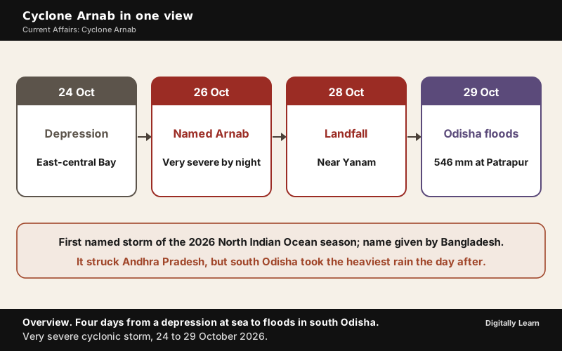
Cyclone Arnab was a very severe cyclonic storm that formed over the Bay of Bengal in late October 2026 and crossed the Andhra Pradesh coast near Yanam on 28 October. The first named storm of the 2026 North Indian Ocean season, it intensified rapidly at sea, and after landfall its rain flooded Ganjam and Gajapati in south Odisha. Its name was given by Bangladesh.
Cyclone Arnab 2026: Formation and Track Over the Bay of Bengal
From Depression to Very Severe Cyclonic Storm, 24 to 26 October
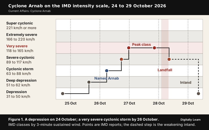
Cyclone Arnab began as a depression over the east-central Bay of Bengal at 5.30 p.m. (1200 UTC) on 24 October 2026, about 820 km east-southeast of Visakhapatnam. The India Meteorological Department (IMD) issued a pre-cyclone watch for the Andhra Pradesh and adjoining south Odisha coasts the same day, and the system then climbed the IMD's intensity scale one step after another.
- 24 October, evening: Depression near 15.8°N, 90.7°E, with winds of 40 to 50 km/h.
- 25 October: Deep depression, still far out at sea.
- 26 October, morning: Cyclonic storm, given the name Arnab.
- 26 October, about 12 hours later: Severe cyclonic storm over the west-central Bay of Bengal.
- 26 October, 11.30 p.m.: Very severe cyclonic storm near 15.9°N, 86.0°E, about 350 km southeast of Visakhapatnam, moving west-northwest at 23 km/h.
Arnab was the first named storm of the 2026 North Indian Ocean cyclone season, a rather late start for a basin that typically produces named cyclones in April or May, and it came during an El Niño. Research has found that the Bay of Bengal sees both less frequent and less intense tropical cyclones in El Niño years.
Cyclone Arnab Landfall Near Yanam and Narsapur, 28 October 2026
Arnab crossed the Andhra Pradesh and Yanam coasts between Bapatla and Visakhapatnam, close to the south of Yanam, as a very severe cyclonic storm. The crossing began near Narsapur in West Godavari district in the early hours of 28 October; the IMD put it between about 2 a.m. and 8 a.m., with sustained winds of 125 to 135 km/h gusting to 150 km/h. The storm weakened into a severe cyclonic storm around 8.30 a.m.
The landfall came hours earlier than forecast. The IMD's bulletin of 27 October expected the crossing by the forenoon of 28 October, but Arnab moved faster than expected towards the coast, stalled for a time and began crossing in the middle of the night. After landfall it crept north at about 7 km/h and still lay about 40 km north of Narsapur and 40 km west of Yanam at 2.30 p.m.
Landfall is the place where a tropical cyclone crosses the coast. A mature tropical cyclone has a calm centre, the eye, a region of subsiding air; around it the eye wall carries a strong spiralling ascent of air, the fastest winds and torrential rain, while at the surface the winds circulate around the low-pressure centre, where air converges and rises. Once over land the storm's moisture supply is cut off and it dissipates, which is why Arnab dropped from a very severe to a severe cyclonic storm within hours of crossing the coast.
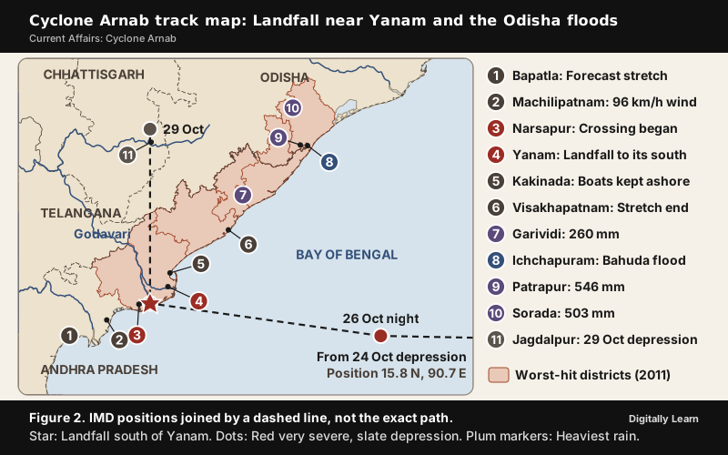
By 8.30 a.m. on 29 October the remnant was a depression about 40 km north-northwest of Jagdalpur in Chhattisgarh, moving north at 18 km/h, and was expected to weaken into a well-marked low-pressure area over north Chhattisgarh and northwest Odisha that evening. Its rain spread to Jharkhand, eastern Madhya Pradesh and West Bengal. A fresh low-pressure area formed over the south Andaman Sea the same morning, and the IMD expected it to become a depression over the southeast Bay of Bengal by 31 October.
The same stretch of coast was struck a year earlier. Cyclone Montha, a severe cyclonic storm, made landfall near Narasapuram around midnight on 29 October 2025; Arnab arrived one category stronger. Why the Bay of Bengal produces so many such storms is explained in Bay of Bengal and Arabian Sea cyclones.
Why Cyclone Arnab Intensified Rapidly: Warm Sea and Forecast Limits
Rapid Intensification and Sea Surface Temperature in the Bay of Bengal
Rapid intensification is a very sharp strengthening of a tropical cyclone in a short time. The most widely used definition is a rise in maximum sustained winds of at least 30 knots (55 km/h) in 24 hours, and it remains a major source of forecast error. Arnab went from a cyclonic storm to a very severe cyclonic storm within a single day, and some forecast models failed to anticipate how strong it would become.
A warm sea explains much of it. Sea surface temperatures over the central Bay of Bengal were about 30 °C, vertical wind shear was moderate, and the Madden-Julian Oscillation was enhancing thunderstorm activity over the region. A tropical cyclone takes its energy from the evaporation of water from the ocean surface, which condenses into clouds and rain as moist air rises and cools.
Sea surface temperature rise, the warming of the ocean's surface layer, therefore bears directly on cyclones.
- Formation: Warm water is needed for a tropical cyclone to form and strengthen; the commonly accepted minimum is 26 to 27 °C, and a cyclone that moves over water much cooler than 26.5 °C can dissipate. Arnab’s sea, at about 30 °C, was well above that mark.
- Intensification: Higher sea surface temperatures bring faster intensification and sometimes rapid intensification; the IPCC’s Sixth Assessment Report of 2021 assessed that rapid intensification has likely become more frequent worldwide over the past four decades.
- Moisture: Warmer air can hold about 7% more water vapour for each 1 °C of warming.
How warming seas are changing cyclones in the Bay of Bengal and the Arabian Sea is taken up in cyclones and climate change.
Moisture From a Second System and the Fujiwhara Effect
While Arnab strengthened, a separate low-pressure system that had given Tamil Nadu nearly 10 days of widespread rain was still lingering far east of that coast. Weather experts said it may have supplied extra moisture to Arnab and helped sustain its cloud bands and rain as it neared Andhra Pradesh. The two did not merge: the IMD noted an interaction between Arnab and a low-pressure area over the southwest Bay of Bengal, but its advisories did not describe a Fujiwhara merger.
The Fujiwhara effect is the interaction of two nearby cyclonic vortices that move around each other and close the distance between their centres. Tropical cyclones typically interact within about 1,400 km of each other, and in the Northern Hemisphere the pair circles anticlockwise about a point between them. The effect is named after the Japanese meteorologist Sakuhei Fujiwhara, who described it in a 1921 paper.
- Effect on movement: The two centres orbit each other, which can bend a track or make a storm stall; in 2009 the interaction of Typhoons Parma and Melor made Parma stall near the Philippines.
- Effect on intensity: Two smaller circulations can build a larger cyclone or merge into one, and a stronger storm can absorb a weaker one, as Hurricane Iris absorbed Hurricane Humberto in 1995.
- Arnab’s case: Arnab was much the stronger system, so moisture feeding or a partial interaction is more likely than a true Fujiwhara merger.
Impact of Cyclone Arnab on Andhra Pradesh and Odisha
Andhra Pradesh: Rainfall, Power Cuts and Crop Damage
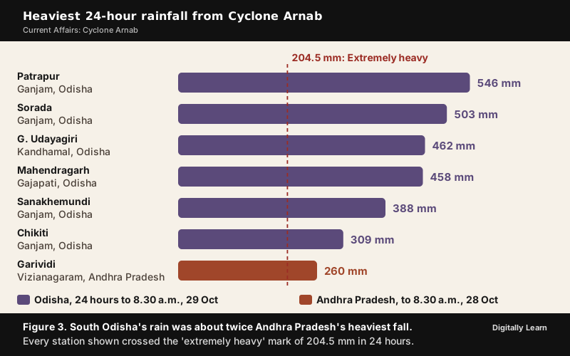
Andhra Pradesh took the wind and the first burst of rain. In the 24 hours to 8.30 a.m. on 28 October, 39 stations in Anakapalli, Visakhapatnam and Vizianagaram received more than 204.5 mm, the mark of 'extremely heavy' rain, and Garividi in Vizianagaram district recorded the highest, 260 mm. The strongest sustained wind measured on land was 96 km/h at Machilipatnam. West Godavari and Dr. B.R. Ambedkar Konaseema districts bore the brunt of the cyclone.
- Lives: Five people died in rain-related incidents by the Chief Minister’s count on 28 October, most of them from falling trees, collapsing poles and electrocution; a lineman repairing power lines in Vizianagaram district died the next day.
- Electricity supply: Supply was cut to 25.33 lakh homes, shops and other non-farm connections in 11 districts; 6,270 electric poles came down and 374 distribution transformers were damaged.
- Crops and trees: Crops, mainly paddy, were inundated over more than 70,000 hectares and horticultural crops were damaged over another 10,500 hectares; more than 1,000 trees were uprooted.
- Coast: The sea surged 1 to 1.5 metres near the landfall zone, a full-moon high tide slowed the flow of rainwater into the sea at Machilipatnam, and six fishing boats were damaged or sunk at the Visakhapatnam Fishing Harbour.
The storm's reach went well beyond the landfall zone. On the evening of 27 October high waves from Arnab lashed the Ennore Expressway in north Chennai, and the National Highways Authority of India closed the road after vehicles were drenched; some fishermen feared a tsunami. The Indian Coast Guard later airlifted crew members of the Sigma Pearl, a bulk carrier stranded in rough sea off Antarvedi in Konaseema district.
Odisha Floods After Cyclone Arnab: Ganjam, Gajapati and the Bahuda
South Odisha faced the greater danger after landfall, when moisture in the storm's outer circulation fell over hilly ground. In the 24 hours to 8.30 a.m. on 29 October, Patrapur in Ganjam district recorded 546 mm and Sorada 503 mm, G. Udayagiri in Kandhamal 462 mm and Mahendragarh in Gajapati 458 mm, while Sanakhemundi and Chikiti in Ganjam passed 300 mm. The IMD described the rain over south Odisha as exceptional, and Chief Minister Mohan Charan Majhi said 17 districts of the State had been affected.
- Marooned villages: More than 200 villages in 22 blocks of Ganjam and Gajapati were badly hit, about 2,000 people were cut off by floodwater in Ganjam, and the State prepared to airlift people with Indian Coast Guard helicopters while rain and low cloud held flights back.
- Roads and crops: A stretch of National Highway 326 linking Ganjam with Mohana was washed away, and paddy nearing harvest was damaged.
- Ground already wet: The rain fell on land still recovering from the fourth wettest monsoon in Odisha’s history; Ganjam alone had lost 33% of its crops by October, and soil that has not drained can flood after even lower rainfall.
The floods crossed the State border along the Bahuda. Water released from the Baghalati dam, in Patrapur block of Ganjam, flooded Ichchapuram and nearby villages in Srikakulam district of Andhra Pradesh during the night of 28 October and disrupted National Highway 16. The river carried 58,436 cusecs on 29 October, and Odisha alerted Andhra Pradesh before releasing about 86,000 cusecs more that afternoon, but power cuts and the loss of the internet hampered warnings and evacuation. The swollen river also forced the cancellation of nine trains on the Howrah-Chennai route.
Who Named Cyclone Arnab: The North Indian Ocean Naming System
Cyclone Naming List of the 13 Panel Countries and Arnab's Place
Cyclone Arnab was named by Bangladesh, and the IMD gives its pronunciation as "Ornab". Storms over the North Indian Ocean, between 45°E and 100°E, are named by the IMD's Regional Specialised Meteorological Centre in New Delhi once they become cyclonic storms, with three-minute sustained winds of at least 34 knots (63 km/h).
The names come from a list in use since 2020, to which 13 countries of the WMO/ESCAP Panel on Tropical Cyclones contributed: Bangladesh, India, Iran, the Maldives, Myanmar, Oman, Pakistan, Qatar, Saudi Arabia, Sri Lanka, Thailand, the United Arab Emirates and Yemen. Each country gave one name to each of 13 rows, 169 names in all, and names are assigned in order. Arnab is the first name of the third row; the next two are Murasu, from India, and Akvan, from Iran.
A name is given only at the cyclonic-storm stage, the third of the IMD's seven classes shown in Figure 1. Below it are the depression (31 to 50 km/h) and the deep depression (51 to 62 km/h); above it come the severe cyclonic storm (89 to 117 km/h), the very severe cyclonic storm (118 to 165 km/h) that Arnab became, the extremely severe cyclonic storm (166 to 220 km/h) and the super cyclonic storm (221 km/h or more).
How Tropical Cyclones Are Named Across the World
Every ocean basin has a warning centre that names its storms. A name makes forecasts and warnings easier to communicate to the public, which matters most when several storms are active in the same basin at once. Names are generally assigned in order from lists prepared in advance, and a name can be retired when a storm causes many deaths or great damage and the members agree it has acquired special notoriety. The storms themselves go by regional names: cyclones in the Indian Ocean, hurricanes in the Atlantic, typhoons in the western Pacific and South China Sea, and willy-willies in Western Australia.
| Basin | Naming centre |
|---|---|
| North Atlantic and eastern North Pacific | United States National Hurricane Center |
| Central North Pacific | United States Central Pacific Hurricane Center |
| Western Pacific | Japan Meteorological Agency (PAGASA names storms locally for the Philippines) |
| North Indian Ocean | India Meteorological Department (RSMC New Delhi) |
| South-West Indian Ocean | Mauritius Meteorological Services and Meteo Madagascar |
| Australian region | Indonesia's meteorological agency, Papua New Guinea's National Weather Service and the Australian Bureau of Meteorology |
| South Pacific | Fiji Meteorological Service and the Meteorological Service of New Zealand |
| South Atlantic | Brazilian Navy Hydrographic Center (unofficial) |
Personal names for weather systems were first used by Clement Wragge, a Queensland government meteorologist, between 1887 and 1907. The practice was revived in the Western Pacific late in the Second World War, and formal naming schemes followed for the other basins, the Indian Ocean among them. The IMD's scale and the full naming rules are set out in cyclone classification, naming and tracking.
Cyclone Arnab and Disaster Management: Warnings, Evacuation and Relief
IMD Four-Stage Cyclone Warning and Colour-Coded Alerts
The IMD warns the coastal States in four stages, and since the post-monsoon season of 2006 the later stages carry colour codes.
- Pre-cyclone watch: Issued 72 hours ahead by the Director General of Meteorology to the Cabinet Secretary and the Chief Secretaries of the coastal States, on a disturbance likely to become a cyclone.
- Cyclone alert (yellow): At least 48 hours before adverse weather begins on the coast, with the storm’s position, intensity and likely track, and advice to fishermen and the public.
- Cyclone warning (orange): At least 24 hours before adverse weather, when the landfall point is forecast; updated every three hours.
- Post-landfall outlook (red): At least 12 hours before landfall, on the storm’s likely movement and the weather inland.
Arnab moved through these stages. The IMD issued the pre-cyclone watch for Andhra Pradesh and adjoining south Odisha with the depression of 24 October, and its national bulletin of 27 October carried a cyclone warning for the same coasts, with the storm under watch of the Doppler Weather Radar at Visakhapatnam.
District weather warnings use colours as well: green means no warning and no action, yellow means be watchful and get updated information, orange means be alert and prepared to act, and red means take action. For 27 October the IMD put seven of Andhra Pradesh's 28 districts on red alert, where isolated extremely heavy rain of 200 mm or more was likely.
Evacuation, NDRF and the Disaster Management Act, 2005
Both States aimed at what they called "zero loss of life and minimal damage to infrastructure". Andhra Pradesh released ₹27 crore to 20 districts, deployed National Disaster Response Force and State Disaster Response Force units, brought 30,043 fishing boats back to harbour and moved 4,711 pregnant women to safer health facilities. Odisha readied 135 permanent cyclone shelters and 1,600 temporary ones and deployed eight NDRF teams and 40 Odisha Disaster Rapid Action Force teams.
This machinery rests on the Disaster Management Act, 2005. The Act provides for the National Disaster Management Authority (NDMA), chaired by the Prime Minister, with State authorities and district authorities below it; a district authority is chaired by the Collector or District Magistrate. Sections 44 and 45 provide for a National Disaster Response Force "for the purpose of specialist response to a threatening disaster situation or disaster".
- NDRF: 16 battalions drawn from the central armed police forces, two of them based in the States Arnab struck, at Vijayawada in Andhra Pradesh and Cuttack in Odisha.
- State forces: Odisha has its own Disaster Rapid Action Force, and it sent 15 more units to Ganjam as the floods rose.
- 2025 amendment: The Disaster Management (Amendment) Act, 2025 was notified in March 2025 to create a disaster database and to address urban disasters.
How the IMD's radars, NDMA's guidelines and cyclone shelters fit together is covered in cyclone forecasting and disaster management.
Community Participation, Relief and the Zero-Disruption Lesson
Community action decided much of the outcome. Fishermen kept their boats ashore after the advisory, and when six boats put out from Kakinada on 25 October despite the alert, the Coast Guard tracked them and directed them back to harbour. In Yanam, near the landfall point and home to more than 55,600 people, only about 2,000 had moved to relief camps by 27 October, and NDRF personnel and the police had to persuade residents to leave. The gaps Arnab exposed point to the remedies: warnings that still reach villages when power and the internet fail, early alerts between States before a dam release, and persuading people to move before a storm arrives at night.
Relief followed landfall. Andhra Pradesh announced ₹5 lakh for the family of each person killed, ₹1,000 for each person in a relief camp up to ₹3,000 a family, ₹10,000 for a partly damaged house and ₹25,000 a hectare for affected paddy, cotton, groundnut and sugarcane. Teams of the Indian Red Cross Society, with doctors and volunteers, joined the relief work in Ichchapuram.
Previous Year UPSC-CSE Questions By the end you will be able to draft model answers for the following UPSC questions. Each question carries a collapsible framework showing how to approach it in the exam.
- UPSC Prelims 2002 Prelims-GSConsider the following Assertion (A) and Reason (R):
- Assertion (A): The surface winds spiral inwards upon the centre of the cyclone.
- Reason (R): Air descends in the centre of the cyclone.
Select the correct answer using the code given below.
How to approach this Prelims question
Approach: Step 1: Test A. At the surface the winds circulate around the cyclone's low-pressure centre and converge on it, so they spiral inwards; A is true. Step 2: Test R. The eye at the centre is a region of calm with subsiding air; R is true. Step 3: Link them. The inward spiral comes from air flowing towards the low pressure and rising in the eye wall; the sinking air in the eye does not drive that inflow, so R does not explain A. Answer (b).
Key facts to recall:
- (a) Both true and R explains A: wrong. The sinking air in the eye does not drive the surface inflow; the low pressure at the centre does.
- (b) Both true, R not the explanation: right. Winds spiral in towards the low, and air subsides in the calm eye, but these are separate features of the storm.
- (c) A true, R false: wrong. The eye is a region of calm with subsiding air, so R is true.
- (d) A false, R true: wrong. Surface winds do circulate around the low-pressure centre and converge on it.
Answer signal: (b): Both statements are true, but the inflow is driven by the low pressure at the centre, not by the sinking air in the eye.
- UPSC Mains 2013 GS-IThe recent cyclone on east coast of India was called ‘Phailin’. How are the tropical cyclones named across the world? Elaborate.
Answer outline: How to structure the answer
What the question asks, the main arguments, relevant examples and the direction of the conclusion. This is not a full model answer.
Introduction: Introduce naming as a way to make forecasts and warnings easy to communicate, most of all when several storms are active in one basin.
Body (sub-themes to develop):
- Basin centres: The US National Hurricane Center (Atlantic and eastern Pacific), the Japan Meteorological Agency (western Pacific), the IMD (North Indian Ocean), Mauritius and Madagascar (south-west Indian Ocean), Indonesia, Papua New Guinea and Australia, Fiji and New Zealand.
- Rules: Names given in order from lists prepared in advance; a name is retired after a storm of special notoriety.
- North Indian Ocean: RSMC New Delhi names a storm at 34 knots (63 km/h); 13 panel countries, 169 names in the 2020 list; Arnab (Bangladesh), October 2026, next Murasu (India).
Conclusion: Conclude that a regional list shared by neighbours also reflects cooperation in early warning across the basin.
- UPSC Mains 2022 GS-IDiscuss the meaning of colour-coded weather warnings for cyclone prone areas given by India Meteorological Department.
Answer outline: How to structure the answer
What the question asks, the main arguments, relevant examples and the direction of the conclusion. This is not a full model answer.
Introduction: Introduce colour codes as impact-linked warnings that tell officials and the public what to do, not only what weather to expect.
Body (sub-themes to develop):
- Colours: Green, no warning and no action; yellow, be watchful and updated; orange, be alert and prepared to act; red, take action.
- Cyclone stages: Pre-cyclone watch at 72 hours; cyclone alert (yellow) at least 48 hours ahead; cyclone warning (orange) at least 24 hours ahead with the landfall point; post-landfall outlook (red) at least 12 hours before landfall.
- Arnab 2026: Pre-cyclone watch with the depression of 24 October; cyclone warning on 27 October; red alerts for seven of 28 Andhra Pradesh districts.
- Limits: An early night landfall narrowed evacuation windows; warnings must reach villages when power and the internet fail.
Conclusion: Conclude that colour codes work when they trigger pre-agreed actions at district level.
- UPSC Mains 2026 GS-IWhat is the Fujiwhara effect? Explain its impact on the movement and intensity of tropical cyclones.
Answer outline: How to structure the answer
What the question asks, the main arguments, relevant examples and the direction of the conclusion. This is not a full model answer.
Introduction: Define the Fujiwhara effect as the interaction of two nearby cyclonic vortices that move around each other and draw closer.
Body (sub-themes to develop):
- Mechanism: Within about 1,400 km for tropical cyclones; the pair turns anticlockwise about a point between them in the Northern Hemisphere.
- Movement: Orbiting bends tracks and can stall a storm (Parma and Melor, 2009).
- Intensity: Two circulations can merge into a larger cyclone, or the stronger absorbs the weaker (Iris absorbed Humberto, 1995).
- Indian example: Arnab, 2026, drew moisture from a weaker system off Tamil Nadu without a merger.
Conclusion: Conclude that binary interaction complicates track and intensity forecasts, so it is watched closely when two systems are active.
- UPSC Mains 2024 GS-IWhat is sea surface temperature rise? How does it affect the formation of tropical cyclones?
Answer outline: How to structure the answer
What the question asks, the main arguments, relevant examples and the direction of the conclusion. This is not a full model answer.
Introduction: Define sea surface temperature rise as the warming of the ocean's surface layer.
Body (sub-themes to develop):
- Energy: Cyclones draw energy from evaporation; vapour condenses into clouds and rain as air rises.
- Threshold: A minimum of about 26 to 27 degrees C is needed to form and strengthen.
- Intensification: Warmer seas bring faster and rapid intensification; IPCC AR6 found rapid intensification likely more frequent over four decades.
- Moisture: About 7% more water vapour per 1 degree C of warming.
- Example: Arnab, October 2026, over a 30 degrees C Bay of Bengal, intensified within a day.
Conclusion: Conclude that warming seas make forecasting and early evacuation more important on India's coasts.
- UPSC Mains 2026 GS-III"Community participation is the cornerstone of effective disaster management". Analyse this statement with suitable examples from India. Also discuss the challenges to community participation and measures to strengthen it.
Answer outline: How to structure the answer
What the question asks, the main arguments, relevant examples and the direction of the conclusion. This is not a full model answer.
Introduction: Introduce the idea that the first responders in any disaster are the people on the spot, within the frame of the Disaster Management Act, 2005.
Body (sub-themes to develop):
- Examples: Fishermen heeding advisories during Arnab (30,043 boats back in Andhra Pradesh); Red Cross volunteers in Ichchapuram; Odisha's shelter network.
- Challenges: Reluctance to leave homes (only about 2,000 of Yanam's 55,600 had moved by 27 October); warnings that arrive at night or fail with power and the internet; coordination across State borders (the Bahuda flood).
- Measures: Warnings that still reach villages when power and the internet fail; early inter-State alerts before dam releases; persuading people to move before a night-time landfall.
Conclusion: Conclude that disaster management works best when communities are partners, which also makes a zero-disruption approach possible.
Sources
- The Hindu, 29 October 2026: Editorial, Hunker down: On Cyclone Arnab, its landfall
- The Hindu, 26 October 2026: A.P., Odisha on alert as cyclone Arnab nears land (highlights)
- The Hindu, 27 October 2026: A.P., Odisha on alert as cyclone Arnab nears land
- The Hindu, 26 October 2026: Over 4,800 fishing vessels return safely to Kakinada coast
- The Hindu, 27-28 October 2026: Cyclone Arnab's landfall process continues along Andhra coast (highlights)
- The Hindu, 27 October 2026: Cyclone Arnab causes high waves in north Chennai, Tiruvallur
- The Hindu, 28 October 2026: Cyclone Arnab highlights, five killed in Andhra Pradesh
- The Hindu, 28 October 2026: 5 dead as Cyclone Arnab batters north Andhra with heavy rain
- The Hindu, 29 October 2026: Cyclone Arnab weakens into a depression (live updates)
- The Hindu, 29 October 2026: Rivers in spate in north Andhra Pradesh, flood water enters Ichchapuram
- The Hindu, 29 October 2026: Odisha prepares to airlift people stranded by floodwater
- The Hindu, 29 October 2026: Low pressure forms in Andaman Sea after Cyclone Arnab
- The Hindu, 29 October 2026: Cyclone Arnab likely drew moisture from Tamil Nadu system, but did not merge
- India Meteorological Department (RSMC New Delhi): Special Tropical Weather Outlook, 24 October 2026
- India Meteorological Department: National Bulletin No. 14 (BOB/08/2026), 27 October 2026
- India Meteorological Department (RSMC New Delhi): Four stage warning
- Press Information Bureau: Impact-based forecasting and colour-coded warnings of the IMD
- NASA Earth Observatory: Arnab Strikes India, 28 October 2026
- Wikipedia: Cyclone Arnab
- Wikipedia: Cyclone Montha
- NCERT: Fundamentals of Physical Geography (Class XI), Chapter 9, Atmospheric Circulation and Weather Systems (Reprint 2026-27)
- Wikipedia: Tropical cyclone scales
- Wikipedia: Tropical cyclone naming
- Wikipedia: Fujiwhara effect
- Wikipedia: Rapid intensification
- Wikipedia: Tropical cyclone
- Wikipedia: Disaster Management Act, 2005
- Wikipedia: National Disaster Response Force
- UPSC: Civil Services Examination question papers
Editorial Disclaimer
This article draws on the India Meteorological Department's bulletins and the other sources listed on this page.


