


Overview
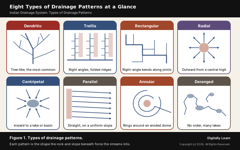
A drainage pattern is the shape that a river and its tributaries make on the map. The main types of drainage patterns are dendritic (tree-like), trellis (tributaries meeting at right angles between folded ridges), rectangular (right-angle bends along joints in the rock), radial (streams flowing out from a high point), centripetal (streams flowing in to a lake or basin), parallel, annular and deranged. Each shape reflects the rock, the slope and the structure beneath, which is why a map of streams can be read like a map of geology.
What Is a Drainage Pattern and What Controls It
What Is a Drainage Pattern?
A drainage pattern is the arrangement of a river and its tributaries in plan view. NCERT defines drainage as the flow of water through well-defined channels and a drainage system as the network of such channels. The shape that network takes is not random. NCERT lists what decides it:
- The geological time period over which the rivers have worked
- The nature and structure of the rocks
- The topography and slope of the land
- The amount of water flowing and how regular that flow is
Because rock and slope decide the shape, geomorphologists read drainage patterns backwards: a trellis of streams points to folded rock, a grid of right-angle bends points to jointed rock, and streams radiating from one spot point to a dome or a peak. All forms of transition occur between parallel, dendritic and trellis patterns.
Types of Drainage Patterns Explained
Dendritic Drainage Pattern: The Tree-Like Network
The dendritic drainage pattern resembles the branches of a tree, and it is the most common drainage pattern of all. The name comes from the Greek for "of or like a tree". Small streams, the twigs, join tributaries, the branches, which join the main river, the trunk.
- Where it forms: On land whose channels follow the general slope of the surface, with V-shaped valleys on rock that is impervious and non-porous.
- Why the shape: With no strong structure to steer them, streams join wherever the slope takes them, at acute angles.
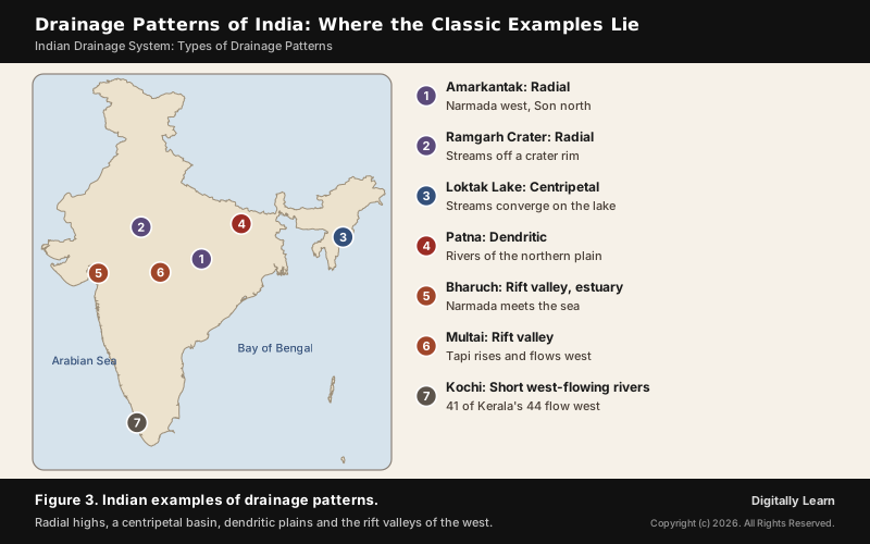
- Indian example: The standard dendritic drainage pattern example in India, as NCERT names it, is the rivers of the northern plain. The Himalayan rivers, NCERT notes, develop a dendritic pattern once they reach the plains.
On a map or a satellite image, a dendritic network is recognised by tributaries that join at acute angles and point roughly downstream, with no preferred direction imposed by the rock. It tells you the ground has no strong structural grain. On the northern plain the pattern sits on deep alluvium, where the Himalayan rivers slow down, meander and, as NCERT notes, shift their courses frequently.
Trellis Drainage Pattern: Right Angles Between Folded Ridges
In a trellis drainage pattern, the primary tributaries flow parallel to one another and the secondary tributaries join them at right angles, like the frame of a garden trellis. It forms where bands of hard and soft rock alternate, as in folded mountains: the main streams run along the valleys of soft rock (strike valleys), and short streams come straight down the steep sides of the ridges between them.
The tributaries are short because each one only has to cross the flank of a single ridge before it reaches the valley floor. The long main streams follow the soft belts because erosion cuts them fastest, and the pattern becomes sharper as erosion deepens the valleys and leaves the hard ridges standing.
- Where it is found: Folded mountains with alternating hard and soft beds.
- Classic example: The best-known trellis drainage pattern example is the Appalachian Mountains of North America; another is the north of Trinidad.
- In India: NCERT groups trellis with radial and rectangular as patterns of the Peninsular rivers, whose courses are superimposed and rejuvenated.
Rectangular Drainage Pattern: Jointed Rock and Right-Angle Bends
A rectangular drainage pattern develops on rock of roughly uniform strength that is cut by two sets of joints at about right angles. The joints are weaker than the rock around them, so erosion opens them first and streams settle along them. The result is streams made of straight segments with sharp right-angle bends, with tributaries also joining at right angles.
The Arun River in Nepal is the example usually cited. A related form, angular drainage, develops where joints and faults cross at angles other than 90 degrees, so the bends are sharp but not square.
The way to tell it on a map is the repeated square turn. A stream runs straight, bends through a right angle, runs straight again and bends again, because it is following one joint and then switching to the crossing joint. The Arun is also the main stream of the Kosi, which NCERT describes as an antecedent river rising north of Mount Everest in Tibet: one river can show a rectangular pattern locally and an antecedent course overall.
Radial Drainage Pattern: Streams Flowing Out from a High Point
In a radial drainage pattern, streams flow outward in all directions from a central high point, like the spokes of a wheel. Volcanoes and domes are its typical settings, because every slope falls away from the centre. The best radial drainage pattern example in India is Amarkantak.
- Amarkantak: NCERT’s example. Amarkantak is the meeting point of the Vindhya and Satpura ranges, with the Maikal Hills at the centre. The Narmada rises on the western flank of the Amarkantak plateau at about 1,057 m and flows west; the Son rises on the same plateau and flows north-east to join the Ganga near Arrah, west of Patna.
- Ramgarh crater: An impact crater in Baran district of Rajasthan, 3.2 km across and rising 150 to 200 m above the plain, named with Amarkantak as India’s most typical radial pattern. The Geological Survey of India has made it a National Geological Monument.
Amarkantak lies in Anuppur district of Madhya Pradesh. Because its rivers leave the same high ground in opposite directions, the Narmada reaching the Arabian Sea and the Son the Bay of Bengal by way of the Ganga, one plateau feeds two seas, which is the clearest sign of a radial centre.
Centripetal Drainage Pattern: Streams Flowing In to a Basin
A centripetal drainage pattern is the reverse of radial: streams from all sides flow in towards a lake or a depression. Because the water collects inland rather than reaching the sea, it is also called inland drainage.
Loktak Lake in Manipur shows the idea. The Manipur River and the Nambul, Yangoi, Nambol and Thongjaorok streams flow into its northern zone, the Khuga and Kangshoibi reach its southern zone, and the lake drains out through the Ithai barrage. Streams converging from around a valley on one lake fit NCERT's definition of centripetal drainage: rivers discharging their waters from all directions into a lake or depression.
The lake covers about 236 square kilometres, and its direct catchment at the Ithai barrage outlet is about 980 square kilometres, much of it under paddy fields, settlement and forest.
- Phumdis: Loktak is known for its phumdis, floating masses of vegetation, soil and organic matter.
- Keibul Lamjao: The largest phumdi carries Keibul Lamjao, the only floating national park in the world and the last natural refuge of the sangai deer.
Parallel Drainage Pattern: Straight Streams on a Steady Slope
In a parallel drainage pattern, streams run swift and straight, side by side, with very few tributaries, all flowing in the same direction. It forms on long, uniform slopes and on elongated landforms such as bands of resistant rock; sometimes it marks a major fault. The rivers flowing south-east from the Aberdare Mountains in Kenya and many rivers of Myanmar are the textbook cases.
The western slope of the Western Ghats fits this description. Of Kerala's 44 rivers, 41 flow west to the Arabian Sea, and NCERT notes that the rivers flowing to the Arabian Sea have short courses. Only three of Kerala's rivers flow east: the Kabini, the Bhavani and the Pambar; the Kabini and the Bhavani join the Kaveri system.
NCERT names several of these short west-flowing rivers:
- Mandovi and Zuari: The two important rivers of Goa.
- Bharathapuzha: The longest river of Kerala, also called the Ponnani, rising near the Annamalai hills and draining about 5,397 square kilometres.
- Periyar: The second largest river of Kerala, with a catchment of about 5,243 square kilometres.
- Pamba: Flows 177 km before falling into Vembanad lake.
Annular and Deranged Drainage Patterns
Two less common patterns complete the set, and both are asked about in definition questions:
- Annular drainage pattern: Streams curve in rings along belts of weak rock around a maturely eroded dome or basin, where erosion has exposed rings of rock of different hardness. The Red Valley, which nearly encircles the Black Hills dome of South Dakota, is the standard example. Impact craters and mud diapirs can also produce it.
- Deranged drainage: A pattern with no coherent order, full of lakes and swamps, found where glaciers scraped the land bare (the Canadian Shield) or where limestone lets surface streams vanish into caves. The basins are young and still sorting themselves out.
Accordant and Discordant Drainage: Antecedent and Superimposed Rivers
Every pattern above is accordant, meaning it fits the rock and relief it flows over. Some rivers do not fit, and their patterns are called discordant. There are two ways a river ends up out of step with the land beneath it:
- Antecedent river: The river existed before the land rose and kept its course by cutting down as fast as the uplift, carving a steep gorge through the rising ridge; this is antecedent drainage. It can keep a dendritic pattern over ground that would otherwise produce trellis drainage.
- Superimposed river: The river formed on younger, horizontal beds lying over folded or faulted rock. Once it cut through the top beds, it kept its course and carried it down into the older rocks below, cutting gorges through their resistant bands.
The Himalayan rivers are India's standard antecedent examples. The Indus, Brahmaputra, Sutlej, Kosi and Subansiri rose on the Tibetan side before the ranges were uplifted and now cross them through deep gorges. NCERT describes the Sutlej, which passes through the Shipki La, the Kosi and the Subansiri as antecedent rivers, and calls the Peninsular rivers superimposed and rejuvenated.
Comparing Drainage Patterns: Differences Students Confuse
Difference Between Radial and Centripetal Drainage Pattern
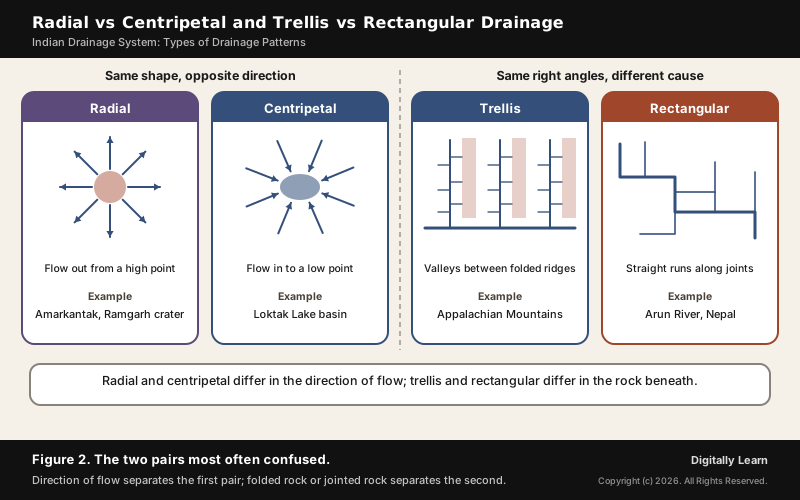
The difference between radial and centripetal drainage is the direction of flow: radial streams flow out from a high point, while centripetal streams flow in to a low point. The two look alike on a map, so check what sits at the centre.
| Basis | Radial | Centripetal |
|---|---|---|
| Direction of flow | Outward, away from the centre | Inward, towards the centre |
| At the centre | A high point: dome, peak or volcano | A low point: lake, basin or depression |
| Where water ends | Scattered to many rivers | Collected in one basin (inland drainage) |
| Indian example | Amarkantak, Ramgarh crater | Loktak Lake |
Difference Between Trellis and Rectangular Drainage Pattern
Both patterns have tributaries meeting at right angles, so the difference lies in the rock beneath: trellis drainage forms on folded rock with alternating hard and soft bands, while rectangular drainage forms on rock of uniform strength broken by joints that cross at right angles.
| Basis | Trellis | Rectangular |
|---|---|---|
| Controlling structure | Folds: parallel ridges and valleys | Joints crossing at right angles |
| Main streams | Long and parallel, in the valleys | Short straight runs with square bends |
| Rock | Alternating hard and soft beds | Roughly uniform rock |
| Example | Appalachian Mountains | Arun River, Nepal |
The table below sets all eight patterns side by side for revision.
| Pattern | Shape | Controlling factor |
|---|---|---|
| Dendritic | Tree-like branches | General slope, impervious rock |
| Trellis | Parallel streams, right-angle tributaries | Folded hard and soft beds |
| Rectangular | Right-angle bends | Two sets of joints |
| Radial | Outward spokes | A dome, peak or volcano |
| Centripetal | Inward spokes | A lake or basin |
| Parallel | Straight streams side by side | A long uniform slope |
| Annular | Rings | An eroded dome or basin |
| Deranged | No order, many lakes | Glaciated land or limestone |
Reading Drainage Patterns on Toposheets and Satellite Images
NCERT's practical geography treats drainage as one of the first things to read on a topographical sheet: the important rivers and their tributaries, the type and extent of the valleys they form, and the type of drainage pattern, such as dendritic, radial, ring, trellis or internal. The pattern is a quick guide to what lies beneath:
- Acute-angle junctions, no preferred direction: Dendritic; uniform ground with no strong structure.
- Long parallel streams with short right-angle feeders: Trellis; folded hard and soft beds.
- Square bends and right-angle junctions: Rectangular; jointed rock.
- Streams leaving or entering one point: Radial on a high, centripetal in a basin.
- Rings of streams: Annular; an eroded dome or basin.
- Lakes and streams with no order: Deranged; glaciated or limestone ground.
Drainage Patterns in India: Examples on the Map
Indian Examples: Amarkantak, Narmada Rift, Loktak and the Western Ghats
NCERT sums up the contrast between India's two river systems in one line each. The Himalayan rivers are antecedent and consequent and develop a dendritic pattern in the plains. The Peninsular rivers are superimposed and rejuvenated, giving trellis, radial and rectangular patterns.
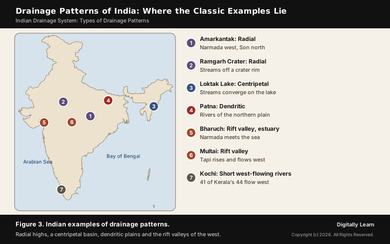
Most Peninsular rivers flow east because the Peninsular block tilted slightly from north-west to south-east, which turned the whole drainage system towards the Bay of Bengal. The Narmada and the Tapi are the exceptions: they flow west in trough faults (rift valleys) that opened when the northern flank of the Peninsula subsided during the rise of the Himalayas. The Narmada runs between the Satpura to the south and the Vindhyan range to the north for about 1,312 km to the Gulf of Khambhat. The Tapi rises at Multai in Betul district of Madhya Pradesh.
Himalayan and Peninsular Rivers: Drainage Patterns Compared
The two great river systems of India show different patterns because they differ in age, source and setting. NCERT compares them point by point:
| Basis | Himalayan rivers | Peninsular rivers |
|---|---|---|
| Source | Himalaya, covered with glaciers | Peninsular plateau and central highland |
| Flow | Perennial: glacier and rain | Seasonal: monsoon rain |
| Type of drainage | Antecedent and consequent; dendritic in the plains | Superimposed and rejuvenated; trellis, radial and rectangular |
| Nature of river | Long courses, headward erosion, river capture; meander and shift in the plains | Smaller, fixed courses with well-adjusted valleys |
| Basin | Very large | Relatively small |
| Age | Young and youthful, still deepening valleys | Old, with graded profiles near base level |
The table explains the map. Young Himalayan rivers flowing onto a vast plain of soft alluvium spread into dendritic networks, while old Peninsular rivers working across hard, faulted and jointed rocks show the structural patterns.
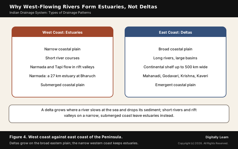
Why West-Flowing Rivers Form Estuaries, Not Deltas
The west-flowing rivers of the Peninsula form estuaries, not deltas, and the reasons lie in their valleys and their coast. A delta grows where a river carrying sediment reaches still water, spreads out, slows down and drops its load. Four conditions on the west coast work against that:
- Rift valleys: The Narmada and the Tapi flow in trough faults and fill the original cracks with their own debris, so NCERT notes a lack of alluvial and deltaic deposits in them. Rift valley rivers form estuaries; the Narmada meets the sea south of Bharuch in a broad estuary about 27 km long.
- Short courses: The rivers flowing to the Arabian Sea have short courses and small basins.
- A narrow, submerged coast: The western coastal plain is narrow and is an example of a submerged coastal plain; NCERT states that the rivers crossing it do not form any delta.
- Against the east coast: The eastern coastal plain is broad and emergent, with a continental shelf extending up to 500 km, and there the Mahanadi, Godavari, Krishna and Kaveri build well-developed deltas.
Drainage Patterns in UPSC Previous Year Questions
UPSC Questions on Drainage Patterns and Indian Rivers
UPSC asks about drainage patterns through Indian examples rather than bare definitions. Knowing where each river rises, which way it flows and why answers nearly every question set so far.
| Year and paper | What was asked | The point tested |
|---|---|---|
| 2004 Prelims | Do west-flowing rivers lack deltas because they carry no sediment? | No deltas is true; no sediment is false |
| 2007 Prelims | Which river originates at Amarkantak? | The Narmada; the Mahanadi rises near Sihawa |
| 2009 Prelims | No east-flowing rivers in Kerala, no west-flowing in Madhya Pradesh? | Both false: Kabini, Bhavani, Pambar; Narmada, Tapi, Mahi |
| 2013 Prelims | Why does the Narmada flow west? | Its rift valley; the Peninsula tilts south-east |
| 2013 Mains, GS Paper I | Why do Western Ghats rivers form no deltas? | Rift valleys, short courses, narrow submerged coast |
| 2023 Prelims | Amarkantak, Biligirirangan and Seshachalam hills | Amarkantak joins Vindhya and Satpura; all three statements false |
In the 2023 question, the other two statements also fail. The Biligirirangan Hills are where the Eastern Ghats begin and meet the Western Ghats, not part of the Satpura Range, and the Seshachalam Hills are part of the Eastern Ghats in Andhra Pradesh, not the southernmost part of the Western Ghats.
Previous Year UPSC-CSE Questions
Previous Year UPSC-CSE Questions By the end you will be able to draft model answers for the following UPSC questions. Each question carries a collapsible framework showing how to approach it in the exam.
- UPSC Prelims 2004 Prelims-GSAssertion (A): West-flowing rivers of Peninsular India have no deltas. Reason (R): These rivers do not carry any alluvial sediment.
How to approach this Prelims question
Approach: Test the Assertion and the Reason separately. West-coast rivers form no deltas, as NCERT notes: A is true. But the rivers do carry sediment: the Narmada and Tapi fill their trough faults with detritus, so R is false. The link fails because R is false.
Trap to watch: The rivers do carry sediment; the Narmada and Tapi deposit it in their rift valleys.
Key facts to recall:
- (a) Both true, R explains A: wrong. R is false: the rivers do carry sediment.
- (b) Both true, R does not explain A: wrong. R is still false.
- (c) A true, R false: right. No deltas, but the sediment is deposited in the rift valleys.
- (d) A false, R true: wrong. A is true and R is false.
Answer signal: A is true and R is false, so option (c) is the answer.
- UPSC Prelims 2007 Prelims-GSWhich one among the following rivers originates at Amarkantak?
How to approach this Prelims question
Approach: Recall the rivers that radiate from Amarkantak, NCERT's example of radial drainage: the Narmada rises on the western flank of the plateau and flows west, and the Son rises on the same plateau and flows north-east. Match that to the options.
Trap to watch: The Mahanadi rises near Sihawa in Chhattisgarh; the Tapi rises at Multai; the Damodar is a Chota Nagpur river.
Key facts to recall:
- (a) Damodar: wrong. It is a Chota Nagpur river, not one of the Amarkantak rivers.
- (b) Mahanadi: wrong. It rises near Sihawa in Chhattisgarh.
- (c) Narmada: right. It rises at Amarkantak at about 1,057 m.
- (d) Tapi: wrong. It rises at Multai.
Answer signal: The Narmada rises at Amarkantak, so option (c) is the answer.
- UPSC Prelims 2009 Prelims-GSConsider the following statements:
- There are no east flowing rivers in Kerala.
- There are no west flowing rivers in Madhya Pradesh.
Which of the statements given above is/are correct?
How to approach this Prelims question
Approach: Each statement says 'no', so one counter-example breaks it. Kerala has three east-flowing rivers, the Kabini, Bhavani and Pambar, so statement 1 fails. Madhya Pradesh has west-flowing rivers, the Narmada, Tapi and Mahi, so statement 2 fails.
Trap to watch: Absolute words: one east-flowing river in Kerala or one west-flowing river in Madhya Pradesh breaks the statement.
Key facts to recall:
- (a) 1 only: wrong. Kerala does have east-flowing rivers: Kabini, Bhavani and Pambar.
- (b) 2 only: wrong. Madhya Pradesh does have west-flowing rivers: Narmada, Tapi and Mahi.
- (c) Both 1 and 2: wrong. Both statements are false.
- (d) Neither 1 nor 2: right. A counter-example breaks each statement.
Answer signal: Neither statement is correct, so option (d) is the answer.
- UPSC Prelims 2013 Prelims-GSThe Narmada river flows to the west, while most other large peninsular rivers flow to the east. Why?
- It occupies a linear rift valley.
- It flows between the Vindhyas and the Satpuras.
- The land slopes to the west from Central India. Select the correct answer using the codes given below:
How to approach this Prelims question
Approach: Keep only the statement that explains the direction of flow. The Narmada flows west because it occupies a rift valley, a trough fault: statement 1 is the cause. Statement 2 describes where the river runs, between the Vindhyas and Satpuras, but does not explain its direction. Statement 3 is false: the Peninsular block tilts from north-west to south-east, which is why most large rivers flow east.
Trap to watch: Statement 2 is a true description but not a cause; statement 3 is false because the Peninsula tilts south-east.
Key facts to recall:
- (a) 1 only: right. The rift valley decides the westward flow.
- (b) 2 and 3 only: wrong. Statement 2 is a description, not a cause, and statement 3 is false.
- (c) 1 and 3 only: wrong. Statement 3 is false: the land slopes to the south-east.
- (d) None: wrong. Statement 1 is the reason.
Answer signal: Only the rift valley explains it, so option (a) is the answer.
- UPSC Prelims 2023 Prelims-GSConsider the following statements:
- Amarkantak Hills are at the confluence of Vindhya and Sahyadri Ranges.
- Biligirirangan Hills constitute the easternmost part of Satpura Range.
- Seshachalam Hills constitute the southernmost part of Western Ghats. How many of the statements given above are correct?
How to approach this Prelims question
Approach: Place each hill range in its true range. Amarkantak is where the Vindhya and Satpura ranges meet, with the Maikal Hills at the centre, not the Sahyadri: statement 1 is false. The Biligirirangan Hills belong to the Eastern Ghats, not the Satpura: statement 2 is false. The Seshachalam Hills are in the Eastern Ghats in Andhra Pradesh, not the Western Ghats: statement 3 is false.
Trap to watch: Amarkantak joins the Vindhya and Satpura, not the Sahyadri; Biligirirangan begins the Eastern Ghats; Seshachalam is in the Eastern Ghats.
Key facts to recall:
- (a) Only one: wrong. None of the three statements is correct.
- (b) Only two: wrong. None is correct.
- (c) All three: wrong. All three place a hill range in the wrong mountain system.
- (d) None: right. Amarkantak joins the Vindhya and Satpura; Biligirirangan and Seshachalam belong to the Eastern Ghats.
Answer signal: None of the statements is correct, so option (d) is the answer.
- UPSC Mains 2013 GS-IThere is no formation of deltas by rivers of the Western Ghat. Why?
Answer outline: how to structure the answer
What the question asks, the main arguments, relevant examples and the direction of the conclusion. This is not a full model answer.
Introduction: West-flowing rivers of the Western Ghats reach the Arabian Sea through estuaries, not deltas.
Body (sub-themes to develop):
- The Narmada and Tapi flow in trough faults and fill them with their own detritus (NCERT).
- Short courses and small basins deliver little load to the coast.
- The western coastal plain is narrow and submerged; rift valley rivers form estuaries.
- Contrast: the broad, emergent east coast with a wide shelf carries the Mahanadi, Godavari, Krishna and Kaveri deltas.
Conclusion: Conclude that structure and coast, not a lack of sediment, explain the absence of deltas.
Sources
- Wikipedia: Drainage system (geomorphology)
- Wikipedia: Amarkantak
- Wikipedia: Narmada River
- Wikipedia: Son River
- Wikipedia: Tapti River
- Wikipedia: Mahi River
- Wikipedia: Mahanadi
- Wikipedia: Loktak Lake
- Wikipedia: List of rivers of Kerala
- Wikipedia: Kabini River
- Wikipedia: Bhavani River
- Wikipedia: Ramgarh crater
- Wikipedia: River delta
- Wikipedia: Biligirirangan Hills
- Wikipedia: Seshachalam Hills
- NCERT: India Physical Environment (Class XI), Drainage System
- NCERT: Practical Work in Geography Part I (Class XI)
- Geological Survey of India
- Central Water Commission
- India-WRIS: Water Resources Information System
- Bhuvan, National Remote Sensing Centre
Disclaimer
This article is a study aid grounded in NCERT and the official sources cited. Pattern classifications follow the standard geomorphological convention; readers cross-checking specific Indian examples should consult Geological Survey of India publications for precise structural boundaries.