
Overview
Previous Year Questions By the end of this article you will be able to draft model answers for the following UPSC questions. Each question carries a collapsible framework showing how to approach it in the exam.
- UPSC Prelims 2025 Prelims: Which of the following are the evidences of the phenomenon of continental drift? I. The belt of ancient rocks from Brazil coast matches with those from Western Africa. II. The gold deposits of Ghana are derived from the Brazil plateau when the two continents lay side by side. III. The Gondwana system of sediments from India is known to have its counterparts in six different landmasses of the Southern Hemisphere. Select the correct answer using the code given below.
How to approach this Prelims question
Approach: Multi-statement evaluation of three continental-drift evidence types. Each statement maps to one of Wegener's evidence pillars: geological-match (I), structural-economic (II), stratigraphic-paleontological (III). Each must be evaluated against the multi-pillar evidence base for Pangaea.
Trap to watch: Aspirants may doubt Statement II (gold deposits) because gold-deposit geology is not the standard Wegener-evidence framework. The trap is to dismiss it; however, the Ghana-Brazil gold-deposit alignment is well-documented in the Birimian greenstone belt that crossed both continents when they were joined. Statement III is precise about the SIX landmasses (South America, Africa, Antarctica, Australia, Madagascar, India); six is the correct count, not five or seven.
Key facts to recall:
- Wegener evidence pillars: geological, paleontological, paleoclimatic, structural, biological.
- Gondwana counterparts: six landmasses (South America, Africa, Antarctica, Australia, Madagascar, India).
- Brazil-West Africa geological match: Precambrian shield and Birimian greenstone belt and early-Paleozoic cover.
- Glossopteris flora: late-Carboniferous seed-fern fossils across all 5 Gondwana fragments and Antarctica.
- Mesosaurus reptile fossil: late-Permian freshwater reptile in South America and Africa only; no transoceanic dispersal route.
Answer signal: (c) I, II and III
- UPSC Mains 2018 GS-I: Define mantle plume and explain its role in plate tectonics.
How to structure the answer in the exam
Introduction: Open by defining mantle plume as a localised column of hot buoyant mantle rock rising from the deep mantle, typically from the core-mantle boundary at 2,900 km depth, to the base of the lithosphere. Note that mantle plumes operate independently of plate-boundary tectonics and account for intra-plate volcanism.
Body (sub-themes to develop):
- Mantle plume mechanism: localised thermal anomaly at the core-mantle boundary develops into a convective column that rises by buoyancy through the lower and upper mantle; plume head and plume tail produce distinct surface expressions.
- Evidence for mantle plumes: (i) seismic-tomography images of low-velocity columns extending from core-mantle boundary, (ii) intra-plate basalt geochemistry differing from MORB, (iii) age-progressive volcanic chains, (iv) topographic swells over active plumes (Hawaiian swell, Reunion swell).
- Role in plate tectonics; intra-plate volcanism: Hawaii-Emperor seamount chain in Pacific (currently Kilauea, 81 Ma to Detroit Seamount); Yellowstone hotspot under North American Plate; Iceland hotspot at North-Atlantic ridge intersection.
- Role in large igneous provinces (LIPs): Deccan Traps (Reunion plume, 66 Ma), Siberian Traps (Permo-Triassic plume, 252 Ma), Ontong Java Plateau (Pacific oceanic plateau, 122 Ma); LIPs correlate with major mass extinctions.
- Role in absolute plate motion: hotspots are approximately fixed in the deep mantle on million-year timescales, so age-progressive volcanic chains record absolute (not just relative) plate motion. The Hawaii-Emperor bend at Daikakuji Seamount records a Pacific-Plate motion change at 47 Ma.
- Role in continental break-up: plume-driven thermal weakening of lithosphere facilitates rifting (East African Rift over the Afar plume, the Atlantic opening over multiple Mesozoic plumes); plumes are co-located with hotspot tracks of newly-separating continents.
- Indian Plate example: the Reunion plume produced the Deccan Traps at 66 Ma when the Indian Plate was over its location; subsequent age-progressive chain extends through Laccadive (60 Ma), Maldives (50 Ma), Chagos (40 Ma), Mascarene (30 Ma) to the active Piton de la Fournaise volcano on Reunion island today.
Conclusion: Conclude by noting that mantle plumes complete the plate-tectonic theoretical framework. They explain intra-plate volcanism that plate-boundary tectonics alone cannot account for, record absolute plate motion through age-progressive chains, contribute to large igneous provinces and mass extinctions, and facilitate continental break-up through lithospheric thermal weakening. The Indian Plate's Reunion-hotspot trajectory makes this theoretical apparatus concretely Indian-relevant.
- UPSC Mains 2013 GS-I: What do you understand about the theory of 'continental drift'? Discuss the prominent evidence in its support.
How to structure the answer in the exam
Introduction: Open by defining continental drift as Wegener's 1912 hypothesis that the present continents were once joined into the supercontinent Pangaea and have since drifted apart. Note the rejection-then-vindication arc: initial rejection for lack of mechanism, vindication in the 1960s through sea-floor spreading.
Body (sub-themes to develop):
- Geological match: Brazil coast Precambrian shield rocks and early-Paleozoic sedimentary cover match West Africa; the Birimian greenstone belt is continuous when the Atlantic is closed.
- Paleontological match: Mesosaurus (Permian freshwater reptile) in South America and Africa only; Glossopteris seed-fern flora across all five Gondwana fragments (South America, Africa, India, Antarctica, Australia); identical Permian beetle and snail species cross-Atlantic.
- Paleoclimatic match: late-Carboniferous to early-Permian glacial striations in South America, southern Africa, India, Antarctica, and Australia indicate joint position near South Pole; equatorial-tropical coal seams in present-day Antarctica indicate former tropical position.
- Structural match: Appalachian mountain belt of eastern North America aligns with Caledonides of Scotland and Scandinavia when Atlantic is closed; Cape Fold Belt of South Africa matches Sierra de la Ventana of Argentina.
- Gondwana stratigraphy: Gondwana sediments (late-Carboniferous to mid-Cretaceous) have counterparts in six Southern-Hemisphere landmasses, providing the integrated stratigraphic record.
Conclusion: Conclude by noting that Wegener's four-pillar evidence base for continental drift was empirically strong but theoretically incomplete without a mechanism. The 1960s sea-floor spreading proposal of Hess and the magnetic-stripe confirmation of Vine and Matthews completed the framework, vindicating Wegener's hypothesis and integrating it into the plate-tectonic paradigm that has organised solid-earth geology since.
Plate tectonics is the unifying theory of solid-earth geology that explains the present positions of continents, the distribution of earthquakes and volcanoes, the geometry of mountain belts, and the ocean-floor topography as the consequence of large rigid lithospheric plates moving over a viscous asthenosphere. The theory emerged in coherent form in the 1960s through the synthesis of Alfred Wegener's continental-drift hypothesis (1912), Harry Hess's sea-floor spreading proposal (1962), and the magnetic-stripe ocean-floor mapping of Vine and Matthews (1963). The Indian subcontinent is the textbook example of an active plate-tectonic regime: the Indian Plate drifted north from Gondwanaland at approximately 15 centimetres per year during the Cretaceous, collided with the Eurasian Plate approximately 50 million years ago, and continues to push north at approximately 5 centimetres per year today, generating the Himalayan orogeny and the country's primary seismic belt.
Background and Historical Context
Plate tectonics is the single most powerful organising framework in physical geography; it explains the spatial pattern of every major geomorphic feature on Earth. The Indian Plate trajectory shapes the Himalayan range, the Indo-Gangetic foreland basin, the Deccan Traps flood-basalt province, the Andaman volcanic arc, and the seismic hazard of approximately 59 per cent of India's land area. UPSC Prelims has tested continental drift evidences, plate boundaries, and Indian Plate kinematics in 2001, 2004, 2013, 2018, 2021, and 2025. UPSC GS-I Mains anchors on plate-tectonic geography while GS-III anchors on the disaster-management consequences. Without the plate-tectonic scaffold, Indian geomorphology reads as a list of features rather than a coherent system.
What is the significance of mastering plate tectonics? The theory yields four predictive results that UPSC questions repeatedly probe: continental positions through deep geological time, the spatial distribution of earthquakes along plate boundaries, the location of active volcanic arcs in subduction zones, and the genesis of intra-plate volcanism through mantle plumes and hotspots. The same scaffold links the Wegener evidence-set (geological, paleontological, paleoclimatic, structural) to modern geodetic GPS plate-motion measurements and to the seismic-tomography imaging of subducting slabs. This integration is what allows a student to reason from a single observation (e.g., the Hawaiian-Emperor seamount chain bend) to the planetary plate-motion record.
The Geological Survey of India (GSI) maintains the operational geological map and the seismotectonic atlas; the National Centre for Seismology (NCS) at New Delhi operates the dense GPS geodetic network that tracks the Indian Plate's continued northward motion at approximately 5 centimetres per year. The NCS-coordinated GPS geodetic network includes stations operated by IISc Bangalore, IIT Kanpur, Wadia Institute Dehradun, and CSIR-NGRI Hyderabad across the Himalayan front. International programmes such as the International Ocean Discovery Program (IODP), the EarthScope framework, and the GPlates reconstruction software provide the data and computational infrastructure that contemporary plate-tectonic research depends on. The Deccan Traps chronology and the Indian Plate-Reunion-hotspot trajectory are active research frontiers that interact with the end-Cretaceous mass-extinction question.
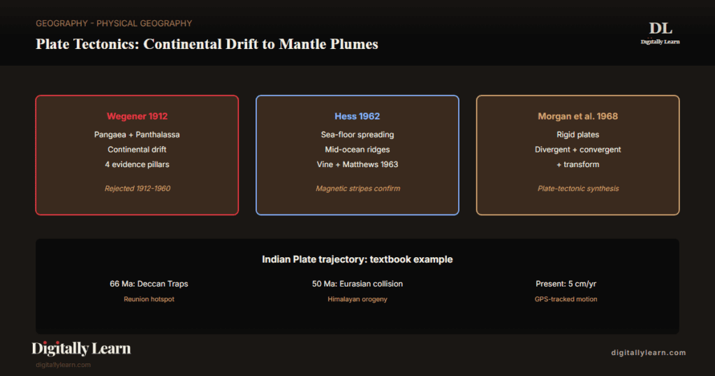
Introduction: The 1960s Paradigm Shift and the Three Foundational Theories
From four fixed continents to a dynamic lithosphere
Before the 1960s, the dominant model of solid-earth geology held that continents and ocean basins were fixed in position. The mountains and ocean trenches were explained through vertical-uplift theories (geosyncline collapse, isostatic adjustment) that did not require horizontal motion. The plate-tectonic paradigm overturned this fixed-Earth view within a single decade, integrating three previously-separate theoretical strands into a unified framework that has shaped solid-earth geology since.
The integration rested on three foundational theories. Alfred Wegener's continental drift hypothesis (1912) proposed that the present continents were once joined into a single supercontinent called Pangaea and have since drifted apart. Harry Hess's sea-floor spreading proposal (1962) identified mid-ocean ridges as the loci of new ocean-floor creation. Fred Vine and Drummond Matthews (1963) mapped the magnetic-stripe pattern of the ocean floor that confirmed Hess's spreading model. Within five years, the synthesis was complete.
- 1912: Wegener proposes continental drift; rejected for lack of mechanism.
- 1962: Hess proposes sea-floor spreading from mid-ocean ridges.
- 1963: Vine and Matthews confirm spreading via symmetric magnetic stripes.
- 1965: Tuzo Wilson introduces transform faults; unifies ridges, trenches, and transforms into a global plate system.
- 1968: Jason Morgan, Dan McKenzie, and Xavier Le Pichon publish the rigid-plate kinematic framework.
Continental Drift (Wegener 1912): Hypothesis, Evidence, and Initial Rejection
Wegener's Pangaea hypothesis and its initial reception
Alfred Wegener, a German meteorologist and polar researcher, presented his continental-drift hypothesis in 1912 and developed it across three editions of Die Entstehung der Kontinente und Ozeane (The Origin of Continents and Oceans, 1915-1929). Wegener proposed that the present continents were once joined into Pangaea (Greek for 'all earth'), surrounded by a single ocean Panthalassa, and have since drifted apart through a process he called Kontinentalverschiebung.
Wegener marshalled a multi-strand evidence base drawn from geology, paleontology, paleoclimatology, and structural geology. The hypothesis was initially rejected by the geological mainstream because Wegener could not propose a credible mechanism for moving continents; his suggested forces (centrifugal effect of Earth rotation, tidal pull of the Sun and Moon) were demonstrably insufficient.
Geophysicist Sir Harold Jeffreys calculated that the proposed forces were too small by orders of magnitude. The hypothesis remained marginal until Arthur Holmes (1928-1944) proposed mantle convection as the missing mechanism.
The four-pillar evidence base for continental drift
Wegener's evidence-set rests on four pillars, each cross-cutting multiple sciences and converging on the same Pangaea-reconstruction. The Prelims 2025 question on continental-drift evidences tests exactly this multi-pillar reasoning.
- Geological match: The rock-types and stratigraphic sequences of the Brazilian coast match those of West Africa across the Atlantic. The belt of ancient rocks from Brazil matches those of Western Africa, including the Precambrian shield rocks and the early-Paleozoic sedimentary cover.
- Paleontological match: Identical fossil species occur on now-separated continents. The freshwater reptile Mesosaurus (Permian) is found in both South America and Africa; the seed fern Glossopteris is found across all five Gondwana fragments (South America, Africa, India, Antarctica, Australia).
- Paleoclimatic match: Glacial striations of late-Carboniferous to early-Permian age occur in South America, southern Africa, India, Antarctica, and Australia, indicating these continents were once joined near the South Pole. Coal seams of equatorial-tropical origin occur in present-day Antarctica.
- Structural match: The Appalachian mountain belt of eastern North America matches the Caledonides of Scotland and Scandinavia when the Atlantic Ocean is closed. The Cape Fold Belt of South Africa matches the Sierra de la Ventana of Argentina.
- Biological match: Identical earthworm and snail species, with limited transoceanic dispersal capability, occur on continents now separated by thousands of kilometres of open ocean.
The Gondwana system: India's role in continental-drift evidence
The Gondwana system of sediments, named after the Gond tribal homeland in central India, occupies a 1,200-kilometre-long belt from the Damodar valley in West Bengal through the Mahanadi valley in Odisha to the Godavari valley in Andhra Pradesh. The system spans the late-Carboniferous to mid-Cretaceous period (approximately 320 to 120 million years ago) and records the full sequence of glacial, fluvial, and lacustrine sediments deposited on the southern supercontinent.
The Gondwana system has counterparts in six landmasses of the Southern Hemisphere: South America (Brazil, Argentina, Uruguay), Africa (Karoo basin), Antarctica (Beacon Supergroup), Australia (Sydney basin), Madagascar, and India. The matching stratigraphy across these six fragments is among the strongest evidence for the Gondwana supercontinent and for the continental-drift hypothesis. The Indian Gondwana coal seams, which power approximately 70 per cent of India's thermal-electricity generation, are direct economic outcomes of this drift history.
Sea-Floor Spreading (Hess 1962): The Missing Mechanism
Hess's sea-floor spreading proposal and the mid-ocean ridge system
Harry Hammond Hess, a Princeton geologist and former US Navy submarine commander, formalised the sea-floor spreading proposal in 1962 in History of Ocean Basins. Hess argued that the mid-ocean ridges were sites of new oceanic crust creation, where hot mantle material rises, partially melts, and forms basaltic ocean floor. The newly-formed crust spreads laterally away from the ridge axis at a rate of 1-10 centimetres per year, eventually being consumed at subduction zones.
The Mid-Atlantic Ridge and the East Pacific Rise are the type-localities of the global mid-ocean ridge system, which extends approximately 65,000 kilometres around the planet. The ridge is a topographic high (1,000-3,000 metres above the surrounding abyssal plain) marked by a central rift valley, active basaltic volcanism, and high heat flow. Ridge-axis basalt samples have radiometric ages younger than 200 million years anywhere in the ocean basins, confirming that ocean floor is continuously recycled.
Vine and Matthews (1963): magnetic stripes as the confirmation
Fred Vine and Drummond Matthews (Cambridge) published the magnetic-stripe confirmation of sea-floor spreading in 1963. They showed that the basaltic ocean floor preserves the Earth's magnetic-field polarity at the time of crystallisation. As new crust forms at the ridge axis and spreads outward, alternating bands of normal and reversed magnetic polarity are frozen into the rock, producing symmetric magnetic stripes on either side of the ridge.
The stripe pattern correlates exactly with the Geomagnetic Polarity Time Scale derived from terrestrial volcanic rocks (Cox, Doell, Dalrymple 1963). The combination of symmetric ocean-floor magnetic stripes with the independently-dated polarity reversal sequence on land provided the decisive falsification test for the fixed-Earth model. By 1965, the sea-floor spreading mechanism was widely accepted.
Plate Boundaries: Divergent, Convergent, Transform
The three plate-boundary types and the global tectonic budget
The rigid-plate kinematic framework recognises three plate-boundary types, distinguished by the relative motion of the plates on either side. Each boundary type produces a distinct topographic, seismic, and volcanic signature. Together they account for nearly all of Earth's earthquakes, volcanoes, and mountain-building activity.
- Divergent boundaries: Plates move apart; new oceanic crust forms by basaltic volcanism. Examples: Mid-Atlantic Ridge, East Pacific Rise, East African Rift (continental divergence in progress). Earthquakes are shallow and moderate; volcanism is effusive basalt.
- Convergent boundaries: Plates move together; one plate is either subducted beneath the other (oceanic-continental or oceanic-oceanic convergence) or both plates collide and crumple (continental-continental collision). Examples: Andean subduction zone (oceanic-continental), Japan trench (oceanic-oceanic), Himalayan collision (continental-continental). Earthquakes span shallow to deep; volcanism is explosive andesite.
- Transform boundaries: Plates slide past one another along a strike-slip fault; lithosphere is neither created nor destroyed. Examples: San Andreas Fault (California), Anatolian Fault (Turkey), Dead Sea Transform. Earthquakes are shallow and can be very large; little or no volcanism.
| Boundary type | Relative motion | Surface signature | Indian Plate example |
|---|---|---|---|
| Divergent | Plates move apart | Mid-ocean ridge; new oceanic crust; basaltic volcanism | Central Indian Ridge (Indian-Antarctic Plate boundary) |
| Convergent (subduction) | Oceanic plate dives under another plate | Ocean trench; volcanic arc; deep earthquakes | Andaman-Sumatran trench (oceanic-oceanic) |
| Convergent (collision) | Two continental plates collide | Fold-and-thrust mountain belt; shallow earthquakes; no volcanism | Himalayan-Tibetan orogeny (Indian-Eurasian Plate) |
| Transform | Plates slide past one another | Strike-slip fault; shallow earthquakes; no volcanism | Owen Fracture Zone (Indian-Arabian Plate) |
Indian Plate boundaries and the seismotectonic consequences
The Indian Plate is surrounded by all three boundary types. The northern boundary against the Eurasian Plate is a continental-continental collision producing the Himalayan-Tibetan orogeny. The eastern boundary is the Andaman-Sumatran subduction zone where the Indian Plate dives under the Burma-Sunda block. The western boundary against the Arabian Plate runs through Pakistan-Iran. The southern boundary against the Antarctic Plate is the Central Indian Ridge, a divergent boundary.
Observable outcomes at the Indian Plate boundary system include the Himalayan-front strain accumulation that drives the country's great-earthquake belt, the Andaman volcanic arc with its only active Indian volcano on Barren Island, and the 2004 magnitude-9.1 Sumatra-Andaman event whose tsunami catalysed India's policy response on early warning.
- (a) Himalayan-front 18-millimetre-per-year strain accumulation that produces magnitude 8 or higher great earthquakes (1934 Bihar-Nepal, 1950 Assam, 2005 Kashmir, 2015 Gorkha).
- (b) The Andaman volcanic arc with Barren Island as India’s only active volcano.
- (c) The 2004 magnitude-9.1 Sumatra-Andaman earthquake and its tsunami that killed approximately 230,000 people across the Indian Ocean rim.
India's National Tsunami Early Warning Centre (INCOIS Hyderabad) was established in 2007 as a direct policy outcome of the 2004 event.
Mantle Plumes and Hotspots: Intra-Plate Volcanism (Mains 2018)
Mantle plume definition and the deep-mantle source
A mantle plume is a localised column of hot, buoyant rock rising from the deep mantle (typically the core-mantle boundary at 2,900 kilometres depth) to the base of the lithosphere. Plumes are inferred from a combination of seismic-tomography, geochemical, and age-progressive lines of evidence, summarised below.
- (i) Seismic-tomography images of low-velocity columns extending from the core-mantle boundary.
- (ii) Geochemical signatures of intra-plate basalts that differ systematically from mid-ocean ridge basalts.
- (iii) Age-progressive volcanic chains that record the trajectory of the overlying plate over the fixed plume.
Plumes form when localised heat anomalies near the core-mantle boundary develop into convective columns that rise through the lower mantle by buoyancy. As a plume head reaches the base of the lithosphere, it spreads laterally and triggers extensive volcanism. The plume tail continues to feed the surface volcano as the lithospheric plate moves over the stationary plume, producing a linear chain of progressively-older volcanic edifices.
Hotspot chains: Hawaii-Emperor and the Deccan-Reunion record
The Hawaii-Emperor seamount chain in the Pacific is the canonical hotspot trajectory. Active basaltic volcanism currently occurs at the south-eastern end (Kilauea on the Big Island of Hawaii); progressively older shield volcanoes extend 5,800 kilometres to the north-west, ending at the 81-million-year-old Detroit Seamount in the Aleutian trench. The 47-million-year-old bend in the chain at Daikakuji Seamount records a major change in Pacific Plate motion.
The Deccan Traps are the Indian-subcontinent expression of the Reunion hotspot trajectory. The Indian Plate passed over the Reunion plume at approximately 66 million years ago, generating the Deccan flood-basalt province. As the Indian Plate moved north and the Reunion plume remained fixed in the mantle, the volcanic activity migrated to the Laccadive-Maldives ridge, the Chagos archipelago, the Mascarene Plateau, and finally to the active Piton de la Fournaise volcano on the present-day Reunion island.
- Deccan Traps eruption: 66.05 to 65.95 million years ago (Schoene et al. 2019 U-Pb dating).
- Indian Plate trajectory: 5,000 kilometres of north-east motion since 66 Ma.
- Hotspot age-progression: Deccan to Laccadive (60 Ma) to Maldives (50 Ma) to Chagos (40 Ma) to Mascarene (30 Ma) to Reunion (active).
- K-Pg mass extinction: The Deccan eruptions coincide with the Chicxulub asteroid impact at the Cretaceous-Paleogene boundary; both contribute to the extinction debate.
Indian Plate Dynamics and Contemporary Geological Frontier
GPS-derived plate kinematics and the strain-budget calculation
The GPS geodetic network operated by the National Centre for Seismology and IISc Bangalore and IIT Kanpur and Wadia Institute Dehradun tracks the Indian Plate's continued northward motion against the Eurasian Plate at approximately 5.0 centimetres per year. The southern Indian Plate moves at 4-5 cm/year; the northern foreland (Indo-Gangetic plain) moves at 3-4 cm/year due to the partitioning of motion across the Himalayan thrust system.
Distinguishing features of the Himalayan strain budget show how convergence partitions between interseismic strain accumulation and coseismic release, as summarised below.
- (i) Approximately 18 millimetres per year of horizontal shortening accommodated across the Himalayan front through the Main Frontal Thrust, the Main Boundary Thrust, and the Main Central Thrust.
- (ii) Interseismic strain accumulation between great earthquakes.
- (iii) Coseismic strain release in magnitude 8 or higher ruptures every 200-500 years at any given segment.
The 2015 magnitude-7.8 Gorkha earthquake released approximately 4 metres of slip on the Main Himalayan Thrust but did not rupture the surface, leaving the central Himalayan seismic gap unrelieved.
Active research frontier: Indian Plate origin and end-Cretaceous extinction
Three contemporary research frontiers define the Indian-Plate plate-tectonic agenda. The Schoene et al. (2019, Science) U-Pb zircon chronology of the Deccan Traps places the main eruption pulse at 66.05 to 65.95 million years ago, straddling the K-Pg boundary and contributing roughly equally with the Chicxulub impact to the end-Cretaceous mass extinction.
Second, the Himalayan seismic gap in the central Himalaya (Uttarakhand to Himachal Pradesh) has not ruptured since 1505; the modelled magnitude-8.5 earthquake hazard is the central seismic risk to north India. Third, the Indian Plate origin from Gondwanaland and the rapid Cretaceous-period north-bound trajectory at approximately 15 cm/year (the fastest plate-motion in geological history) remain active areas of paleogeographic reconstruction research.
Prelims MCQ practice
Each question below tests one specific concept from this article. Click to reveal the answer and a full option-wise explanation.
Q1. With reference to the supercontinent Pangaea proposed by Alfred Wegener, consider the following statements:
- Pangaea was surrounded by a single global ocean called Panthalassa.
- Pangaea began to break up in the early-Jurassic period approximately 200 million years ago.
- Pangaea included only the present-day Southern-Hemisphere continents and excluded North America and Eurasia.
Which of the statements given above is/are correct?
- 1 only
- 1 and 2 only
- 2 and 3 only
- 1, 2 and 3
Show answer and explanation
Answer: 1 and 2 only
Explanation.
Statement 1 is correct: Pangaea was surrounded by the single global ocean Panthalassa. Statement 2 is correct: Pangaea began to break up in the early-Jurassic period (approximately 200 Ma) through the opening of the Tethys Sea between Laurasia (Northern Hemisphere) and Gondwana (Southern Hemisphere). Statement 3 is INCORRECT: Pangaea included ALL present continents, both Northern and Southern Hemisphere. The Northern part (Laurasia) included North America, Europe, and Asia; the Southern part (Gondwana) included South America, Africa, India, Antarctica, and Australia. The correct answer is (b) 1 and 2 only.
Q2. Consider the following statements regarding sea-floor spreading:
- Sea-floor spreading was proposed by Harry Hess in 1962 in his paper History of Ocean Basins.
- The Mid-Atlantic Ridge spreads at approximately 1 to 4 centimetres per year.
- Ocean-floor basalt anywhere on Earth has a radiometric age younger than 200 million years.
Which of the statements given above is/are correct?
- 1 only
- 1 and 3 only
- 2 and 3 only
- 1, 2 and 3
Show answer and explanation
Answer: 1, 2 and 3
Explanation.
All three statements are correct per standard plate-tectonics references. Statement 1: Hess (1962) formalised sea-floor spreading in his History of Ocean Basins monograph. Statement 2: the Mid-Atlantic Ridge spreads at 1-4 cm/year (slow-spreading ridge); the East Pacific Rise spreads at 6-15 cm/year (fast-spreading). Statement 3: oceanic crust is continuously created at mid-ocean ridges and consumed at subduction zones, so any sample of ocean-floor basalt has an age younger than 200 Ma; the oldest preserved oceanic crust (eastern Mediterranean) is approximately 280 Ma but most is much younger. The correct answer is (d) 1, 2 and 3.
Q3. Consider the following plate boundary pairs:
- Mid-Atlantic Ridge: divergent boundary
- Andean subduction zone: transform boundary
- San Andreas Fault: convergent boundary
Which of the pairings given above is/are correctly matched?
- 1 only
- 1 and 2 only
- 1 and 3 only
- 1, 2 and 3
Show answer and explanation
Answer: 1 only
Explanation.
Statement 1 is correct: the Mid-Atlantic Ridge is the type-locality divergent boundary where new oceanic crust forms. Statement 2 is INCORRECT: the Andean subduction zone is a CONVERGENT boundary (oceanic Nazca Plate subducting under continental South American Plate), not a transform. Statement 3 is INCORRECT: the San Andreas Fault is a TRANSFORM boundary (Pacific Plate sliding past North American Plate), not convergent. The correct answer is (a) 1 only.
Sources and Further Reading
- NCERT Class 11 Fundamentals of Physical Geography, Chapter 4 – Distribution of Oceans and Continents
- Geological Survey of India – Bhukosh portal
- National Centre for Seismology – About
- USGS Earthquake Hazards Program – Plate Tectonics
- Wikipedia – Plate Tectonics
- Wikipedia – Continental Drift
- Wikipedia – Sea-floor spreading
- Wikipedia – Indian Plate
- Wikipedia – Mantle plume
- Wikipedia – Hawaii hotspot
- Wikipedia – Deccan Traps
Disclaimer
This article is prepared for UPSC preparation by Digitally Learn's editorial team. It covers the plate tectonics paradigm, Wegener's continental drift, Hess's sea-floor spreading, the three plate-boundary types (divergent, convergent, transform), and the major Indian implications including Himalayan uplift and Deccan Trap volcanism based on NCERT Class 11 Fundamentals of Physical Geography Chapter 4, USGS earth-systems programme, Geological Survey of India, NASA Earth Observatory, and Wegener's original 1912 framing. Key concepts and major tectonic features are cross-verified with standard reference sources like USGS.


