


Overview
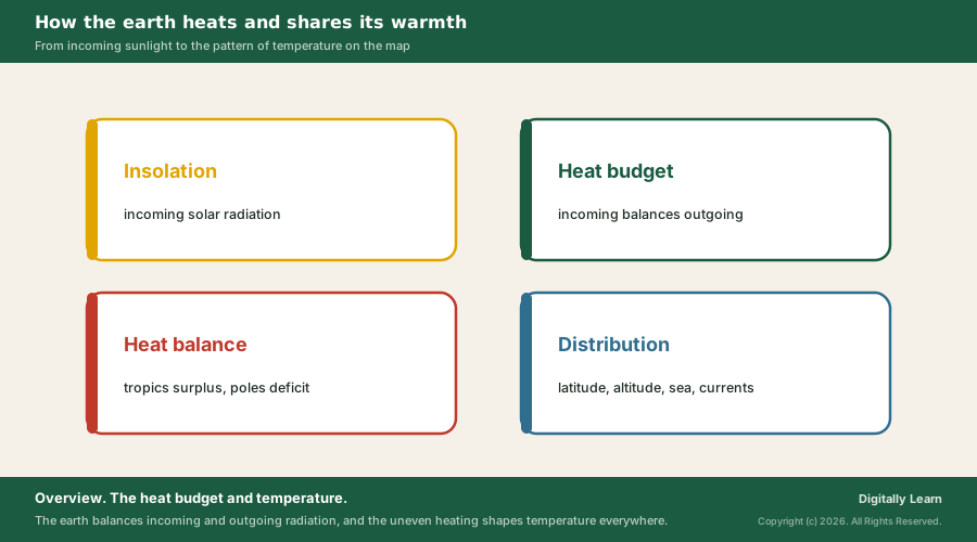
The heat budget of the earth is the balance between the heat the earth receives from the sun as insolation and the heat it sends back to space as terrestrial radiation. Of every 100 units of insolation, 35 are reflected and 65 absorbed, and the earth and its atmosphere return the same 65 units to space, which is why the earth as a whole neither warms up nor cools down over time.
Heat Budget of the Earth: Meaning and Radiative Balance
What Is Heat Budget? The Earth's Energy Balance
The heat budget is the account of how much heat the earth receives and how much it gives back. The earth receives almost all its energy from the sun and, in turn, radiates back to space the energy it receives. Because the two amounts are equal over time, the earth as a whole neither warms up nor cools down.
The heat is not shared out evenly, however. Some parts of the earth receive more than others, and this unequal heating creates differences in air pressure, which set the winds moving and carry heat from one region to another. The heat budget is therefore the starting point for understanding pressure, winds, ocean currents and climate.
- Radiative equilibrium: When incoming solar energy is balanced by an equal flow of heat to space, the earth is in radiative equilibrium and global temperature stays relatively stable.
- Global warming: When the earth receives more energy than it gives back, it warms; when it loses more, it cools.
- Smaller sources: The earth’s internal heat also counts, but it is tiny beside the sun’s energy.
Insolation: Meaning, Factors and Distribution of Solar Radiation
Insolation Meaning: Incoming Short-Wave Solar Radiation
The energy the earth receives from the sun is called insolation, short for incoming solar radiation. It arrives mostly in short wavelengths. Because the earth is a near-sphere, the sun's rays strike the top of the atmosphere at a slant, and the earth intercepts only a very small part of the sun's output.
- At the top of the atmosphere: On average the earth receives 1.94 calories per square centimetre per minute; averaged over the whole planet this is about 340 watts per square metre.
- Aphelion: On 4 July the earth is farthest from the sun, 152 million km away.
- Perihelion: On 3 January it is nearest, 147 million km away, so insolation on 3 January is slightly more than on 4 July.
Factors Affecting Insolation: Angle of the Sun's Rays and Day Length
The amount and intensity of insolation vary through the day, the season and the year. Five factors cause the variation; the last two have less influence than the first three.
- Rotation: The earth’s rotation on its axis brings day and night.
- Angle of the sun’s rays: The higher the latitude, the more slanting the rays. A slant ray spreads its energy over a larger area and passes through more atmosphere, so more of it is absorbed, scattered and diffused.
- Length of the day: It changes with latitude and season.
- Transparency of the atmosphere: Clouds, dust and water vapour cut the energy that reaches the ground.
- Aspect of the land: The direction a slope faces.
The earth's axis makes an angle of 66.5 degrees with the plane of its orbit, and this tilt has the greatest influence on how much insolation each latitude receives, because it changes the length of the day.
| Latitude | Day length on 22 December | Day length on 21 June |
|---|---|---|
| 0 degrees | 12 h 00 m | 12 h |
| 20 degrees N | 10 h 48 m | 13 h 12 m |
| 40 degrees N | 9 h 8 m | 14 h 52 m |
| 60 degrees N | 5 h 33 m | 18 h 27 m |
| 90 degrees N | 0 | 6 months |
Distribution of Insolation: Why the Subtropics Are Hottest
Insolation at the surface ranges from about 320 watts per square metre in the tropics to about 70 watts per square metre at the poles. On its way down, the atmosphere treats the sunlight in two ways: water vapour, ozone and other gases absorb much of the near-infrared, and tiny particles scatter visible light, which gives the sky its blue colour and the rising and setting sun its red.
- Subtropical deserts receive the most: Cloudiness there is the least, so maximum insolation reaches the ground.
- Equator: It receives less than the tropics; its skies are cloudier than those of the subtropics.
- Land and sea: Land receives more than sea at the same latitude.
- Winter: Middle and high latitudes receive less radiation than in summer.
Heating and Cooling of the Atmosphere: Terrestrial Radiation
Conduction, Convection and Advection in the Atmosphere
The earth, once heated by insolation, passes heat to the air above it in three ways. Each moves heat in a different direction and matters in a different place.
- Conduction: Heat flows from a warmer body to a cooler one in contact with it. Air touching the warm ground heats slowly, and the layers above are heated by the layers below; conduction warms the lowest layers of the atmosphere.
- Convection: Heated air rises in currents and carries heat upward. This vertical transfer is confined to the troposphere.
- Advection: Heat moves sideways with horizontal winds. In middle latitudes most of the day-to-night change in weather comes from advection, and in northern India the hot summer wind, the loo, is its product.
The loo is a strong, dusty, hot and dry westerly wind of the Indo-Gangetic Plain, strongest in May and June. Its temperatures of 45 to 50 degrees C make heatstroke a real danger, which is why advection is not an abstract idea for north India.
Terrestrial Radiation and the Greenhouse Effect
The earth, warmed by short-wave insolation, becomes a radiating body itself and sends energy upward in long-wave form. This is terrestrial radiation, and it heats the atmosphere from below. Carbon dioxide and the other greenhouse gases absorb long-wave radiation well, so the atmosphere is heated indirectly, by the earth, rather than directly by the sun. All the energy the earth emits is infrared, and it can be seen indirectly as the shimmer rising above a hot road on a sunny day.
The greenhouse effect is the result: heat-trapping gases slow the rate at which the earth loses heat to space. Without it the earth's average surface temperature would be about minus 18 degrees C; with it, the average is around 15 degrees C, a difference of 33 degrees C.
Human activity has added to these gases. Burning fossil fuels has raised carbon dioxide and methane, and by 2023 about 1.2 degrees C of global warming had occurred since the Industrial Revolution. The causes and effects are covered in global warming.
Heat Budget of the Planet Earth: The 100-Unit Balance
Heat Budget of the Earth Diagram: Where 100 Units of Insolation Go
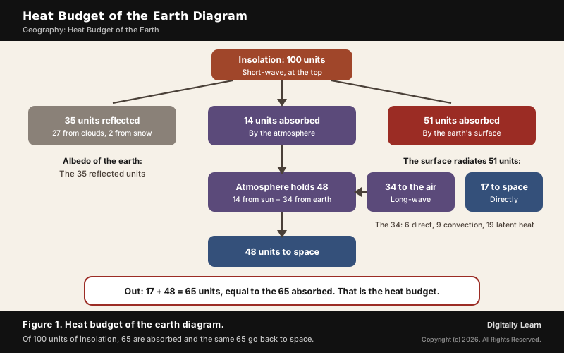
The heat budget is easiest to follow with 100 units of insolation arriving at the top of the atmosphere. Some is reflected, some absorbed on the way down, and the rest absorbed by the ground; then the ground and the air send it all back. The balance holds both at the top of the atmosphere and within the atmosphere itself.
- Reflected, 35 units: Sent back to space before reaching the surface, 27 from the tops of clouds and 2 from snow and ice. This reflected share is the albedo of the earth.
- Absorbed by the atmosphere: 14 units.
- Absorbed by the surface: 51 units.
- Surface radiates, 51 units: 17 go straight to space and 34 are absorbed by the atmosphere: 6 directly, 9 by convection and turbulence, and 19 as latent heat of condensation.
- Atmosphere radiates, 48 units: The 14 it took from the sun plus the 34 from the earth, all returned to space.
- Balance: 17 plus 48 is 65 units out, equal to the 65 units absorbed.
Albedo and Clouds in the Earth's Energy Balance
Albedo is the share of sunlight a surface reflects. The average albedo of the earth is about 0.3, which matches the 29 to 35 per cent of insolation sent straight back to space. Surfaces differ widely, and that is why land use and ice cover matter to climate.
- High albedo: Fresh snow, sea ice under snow, and deserts, some of the brightest landforms.
- Low albedo: The open ocean and most forests, which absorb most of the light; forests use much of it in photosynthesis.
- Human change: Deforestation, farming and urbanisation alter the albedo of large areas.
Clouds work both ways. They reflect sunlight back to space, a cooling effect, and they also trap heat radiated from below, a warming effect. Low clouds have the stronger cooling effect and high clouds the stronger warming effect; taken together, the world's clouds cool the earth by about 13 watts per square metre.
Latitudinal Heat Balance: Tropical Surplus and Polar Deficit
The heat budget balances for the earth as a whole, not for every latitude. There is a surplus of net radiation between about 40 degrees N and 40 degrees S, and a deficit towards the poles. The sun heats the equatorial regions more than the polar regions because the earth is a sphere.
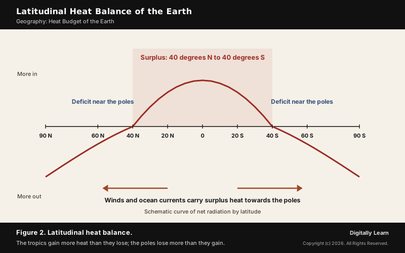
If nothing moved the surplus, the tropics would grow steadily hotter and the high latitudes would freeze for good. Instead, the atmosphere and oceans carry heat poleward without pause, through evaporation, convection, rainfall, winds and ocean circulation. This coupled circulation of air and ocean is called the earth's heat engine.
Earth's Energy Imbalance and Global Warming
The earth's energy budget depends on aerosols, greenhouse gases, surface albedo, clouds and land use. When the flows in and out are equal the climate is stable; when more comes in than goes out, the earth warms. Measurements show such a warming imbalance since at least 1970.
- Size of the imbalance: From 2005 to 2019 it averaged about 0.90 watts per square metre over the whole globe.
- Main cause: Human-induced changes in the composition of the atmosphere, such as added greenhouse gases.
Distribution of Temperature: Factors, Isotherms and Annual Range
Factors Controlling the Distribution of Temperature
The temperature of the air at any place is controlled by five factors, which together explain almost every pattern on a temperature map.
- Latitude: Temperature follows the insolation a place receives, which falls with latitude.
- Altitude: The atmosphere is heated from below, so temperature falls with height at the normal lapse rate of 6.5 degrees C per 1,000 m.
- Distance from the sea: The sea heats and cools slowly and land quickly, so coastal places have milder temperatures, eased further by land and sea breezes.
- Air masses and ocean currents: Warm air masses and warm currents raise temperatures; cold ones lower them.
- Local aspects: Slope, shelter and similar local features.
Isotherms in January and July: Global Distribution of Temperature
Lines joining places of equal temperature are called isotherms. On world maps they run broadly parallel to the lines of latitude, which shows how strongly latitude controls temperature, but they bend where land and sea or ocean currents interfere, more in January than in July and more in the northern hemisphere, which has far more land.
- January, northern hemisphere: Isotherms bend north over the oceans and south over the continents. Over the North Atlantic the warm Gulf Stream and North Atlantic Drift push them north; over Europe and above all the Siberian plain they bend sharply south.
- January values: Over 27 degrees C over equatorial oceans, over 24 degrees C in the tropics, 2 to 0 degrees C in middle latitudes and minus 18 to minus 48 degrees C in the interior of Eurasia.
- Southern hemisphere: With more ocean, isotherms stay nearly parallel to latitude; the 20, 10 and 0 degrees C isotherms follow roughly 35, 45 and 60 degrees S.
- July: Isotherms run close to the parallels; equatorial oceans stay above 27 degrees C and land along 30 degrees N in subtropical Asia exceeds 30 degrees C.
The annual range of temperature, the difference between the warmest and coldest months, shows the same land-sea contrast. It exceeds 60 degrees C over north-eastern Eurasia because of continentality, and is least, about 3 degrees C, between 20 degrees S and 15 degrees N.
Temperature Inversion and Urban Heat Island
Temperature Inversion: Meaning, Causes and Types
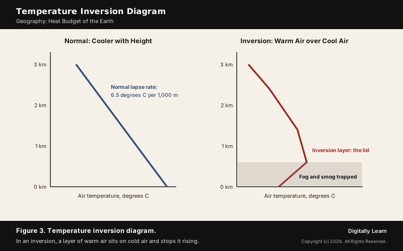
A temperature inversion is a layer of warmer air lying over cooler air. Normally the air cools with height, because the atmosphere is heated from below; in an inversion that order is reversed near the ground or aloft.
- Radiation inversion: Forms when the ground loses more heat by radiation than it receives from the sun, as on long clear nights and in winter when the sun is low. It is almost confined to land, since the ocean holds its heat far longer, and in polar winters it is nearly always present.
- Frontal or advection inversion: A warmer, lighter air mass moves over a cooler, denser one, as near warm fronts or over cold upwelling water such as off the California coast.
- Subsidence inversion: Air sinking over a wide area warms by compression aloft, typically under the subtropical high-pressure belts.
- Valley inversion: Cold air collects in valleys and basins, where the terrain restricts airflow and holds cold air and pollutants near the ground.
Effects of Temperature Inversion on Weather and People
An inversion acts as a lid. It stops the normal rising of air, so whatever is released near the ground stays there. That single effect explains most of its consequences for weather and for the people who live beneath it.
- Air pollution and smog: Stable air stops vertical mixing, so pollutants build up near the ground; cities suffer most, and more so when hills surround them.
- Fog: With enough moisture in the cold layer, fog forms beneath the inversion.
- Suppressed then violent weather: A capping inversion shuts off convection, but if the cap is broken the stored energy can burst out as severe thunderstorms.
- Freezing rain and ice pellets: In winter, snow melting in a warm layer aloft refreezes in the cold layer below.
- Mirages: Distant objects appear stretched or above the horizon.
North India shows the effect every winter. In Delhi, the post-monsoon and winter months bring lower temperatures, lower mixing heights, inversion conditions and calm winds, which trap pollutants and push the city's air quality to its worst.
Urban Heat Island: Causes and Effects
An urban heat island is a city that is noticeably warmer than the countryside around it. The difference is usually larger at night than by day and is clearest when winds are weak. Urban areas occupy about 0.5 per cent of the earth's land but hold more than half of its people, so the effect touches a great many lives.
- Changed surfaces: The main cause. Dark roads and roofs of concrete and asphalt absorb more sunlight and store more heat than fields and forests.
- Less evapotranspiration: With little vegetation and water, there is less cooling by evaporation.
- City design: Street layout and building size reduce ventilation and trap heat.
- Waste heat: Energy used in homes, industry and transport adds heat directly, a secondary cause.
The effects reach beyond comfort. Heat islands increase rainfall downwind of cities, lengthen growing seasons, worsen air quality by raising ground-level ozone, and warm the water that runs off into streams. Tree cover, green roofs, ventilation corridors and lighter-coloured surfaces reduce the heat.
Previous Year UPSC-CSE Questions
Previous Year UPSC-CSE Questions By the end you will be able to draft model answers for the following UPSC questions. Each question carries a collapsible framework showing how to approach it in the exam.
- UPSC Mains 2013 GS-IWhat do you understand about the phenomenon of temperature inversion in meteorology? How does it affect the weather and the habitants of the place?
Answer outline: how to structure the answer
What the question asks, the main arguments, relevant examples and the direction of the conclusion. This is not a full model answer.
Introduction: Define temperature inversion as warmer air over cooler air, the reverse of the normal lapse rate of 6.5 degrees C per 1,000 m.
Body (sub-themes to develop):
- Types: radiation (clear winter nights), frontal or advection, subsidence, valley.
- Weather: fog, stable air, freezing rain, capped convection and sudden thunderstorms.
- Inhabitants: smog and respiratory illness, pollution held in valleys and basins, fog.
- India: winter inversions and low mixing heights over Delhi and the Indo-Gangetic plain.
Conclusion: Conclude that an inversion is a lid on the lower atmosphere, harmless in itself but dangerous where it traps pollution.
- UPSC Mains 2013 GS-IBring out the causes for the formation of heat islands in the urban habitat of the world.
Answer outline: how to structure the answer
What the question asks, the main arguments, relevant examples and the direction of the conclusion. This is not a full model answer.
Introduction: Define an urban heat island as a city warmer than its surroundings, most at night and in calm weather.
Body (sub-themes to develop):
- Land surface change: concrete and asphalt, dark surfaces with low albedo.
- Loss of vegetation and water: less evapotranspiration.
- Built form: street layout and building size that cut ventilation.
- Waste heat from homes, industry and vehicles.
Conclusion: Conclude with remedies: trees, green roofs, ventilation corridors, lighter surfaces.
- UPSC Prelims 2024 Prelims-GSConsider the following statements:
- Statement-I: The atmosphere is heated more by incoming solar radiation than by terrestrial radiation.
- Statement-II: Carbon dioxide and other greenhouse gases in the atmosphere are good absorbers of long wave radiation.
Which one of the following is correct in respect of the above statements?
How to approach this Prelims question
Approach: Ask which radiation the atmosphere absorbs well: long-wave, from the earth.
Trap to watch: It feels natural that the sun heats the air directly; it mostly does not.
Key facts to recall:
- (a) Both correct, II explains I: wrong. Statement I is incorrect: the atmosphere is heated mainly by terrestrial radiation, not by incoming solar radiation.
- (b) Both correct, II does not explain I: wrong, for the same reason: Statement I is incorrect.
- (c) I correct, II incorrect: wrong. It is the other way round: Statement I is incorrect and Statement II is correct.
- (d) I incorrect, II correct: right. The atmosphere is largely transparent to short-wave insolation, and greenhouse gases absorb the long-wave radiation the earth gives out.
Answer signal: Statement I incorrect, Statement II correct, option (d).
- UPSC Prelims 2025 Prelims-GSConsider the following statements:
- Statement-I: In January, in the Northern Hemisphere, the isotherms bend equatorward while crossing the landmasses, and poleward while crossing the oceans.
- Statement-II: In January, the air over the oceans is warmer than that over the landmasses in the Northern Hemisphere.
Which one of the following is correct in respect of the above statements?
How to approach this Prelims question
Approach: Recall the January map: isotherms bend south over cold continents and north over warmer oceans.
Trap to watch: Equatorward over land means southward in the northern hemisphere.
Key facts to recall:
- (a) Both correct, II explains I: right. In January the land cools quickly and the sea slowly, so the air over the oceans is warmer and pulls the isotherms poleward, while over the cold land they bend equatorward.
- (b) Both correct, II does not explain I: wrong. The warmer air over the oceans is exactly why the isotherms bend as they do.
- (c) I correct, II not correct: wrong. Statement II is correct: in January the air over the northern oceans is warmer than over the land.
- (d) I not correct, II correct: wrong. Statement I is correct; over the Siberian plain, for example, the isotherms bend sharply south.
Answer signal: Both correct and II explains I, option (a).
- UPSC Prelims 2024 Prelims-GSWhich of the following is/are correct inference/inferences from isothermal maps in the month of January?
- The isotherms deviate to the north over the ocean and to the south over the continent.
- The presence of cold ocean currents, Gulf Stream and North Atlantic Drift make the North Atlantic Ocean colder and the isotherms bend towards the north.
Select the answer using the code given below:
How to approach this Prelims question
Approach: Check the direction of the bend, then the nature of the currents.
Trap to watch: Statement 2 calls warm currents cold.
Key facts to recall:
- (a) 1 only: right. In January the isotherms deviate north over the ocean and south over the continent.
- (b) 2 only: wrong. Statement 2 is false: the Gulf Stream and the North Atlantic Drift are warm currents, which is why they push the isotherms north.
- (c) Both 1 and 2: wrong, since statement 2 is false.
- (d) Neither 1 nor 2: wrong, since statement 1 is correct.
Answer signal: 1 only, option (a).
- UPSC Prelims 2013 Prelims-GSThe annual range of temperature in the interior of the continents is high as compared to coastal areas. What is/are the reason/reasons?
- Thermal difference between land and water
- Variation in altitude between continents and oceans
- Presence of strong winds in the interior
- Heavy rains in the interior as compared to coasts
Select the correct answer using the codes given below.
How to approach this Prelims question
Approach: Keep only the reason that explains the range: the thermal difference of land and water.
Trap to watch: Altitude, wind and rain are distractors.
Key facts to recall:
- (a) 1 only: right. Land heats and cools faster than water, so interiors far from the sea have the widest annual range.
- (b) 1 and 2 only: wrong. Altitude is not the reason; the range depends on distance from the sea.
- (c) 2 and 3 only: wrong. It leaves out the land and water difference and keeps altitude and strong winds, neither of which causes the range.
- (d) 1, 2, 3 and 4: wrong. Altitude, strong winds and heavy rain in the interior are not causes of the high annual range.
Answer signal: 1 only, option (a).
- UPSC Prelims 2022 Prelims-GSConsider the following statements:
- High clouds primarily reflect solar radiation and cool the surface of the Earth.
- Low clouds have a high absorption of infrared radiation emanating from the Earth's surface and thus cause warming effect.
Which of the statements given above is/are correct?
How to approach this Prelims question
Approach: Swap test: check whether each statement gives the right cloud height for the right effect.
Trap to watch: Both statements reverse high and low clouds.
Key facts to recall:
- (a) 1 only: wrong. Statement 1 is reversed: high clouds have the stronger warming effect, not cooling.
- (b) 2 only: wrong. Statement 2 is reversed: low clouds have the stronger cooling effect, not warming.
- (c) Both 1 and 2: wrong, since both statements reverse the real effects.
- (d) Neither 1 nor 2: right. Low clouds cool the earth more strongly and high clouds warm it more strongly, the opposite of what the statements say.
Answer signal: Neither statement, option (d).
Sources
- NCERT: Fundamentals of Physical Geography (Class XI), Solar Radiation, Heat Balance and Temperature
- NASA Earth Observatory: Climate and Earth's Energy Budget
- World Meteorological Organization: WMO confirms 2024 as warmest year on record (10 January 2025)
- NOAA JetStream: The Earth-Atmosphere Energy Balance
- PIB (MoEFCC): Air Quality Index, Delhi, winter meteorology
- Wikipedia: Inversion (meteorology)
- Wikipedia: Albedo
- Wikipedia: Cloud forcing
- Wikipedia: Greenhouse effect
- Wikipedia: Urban heat island
- Wikipedia: Loo (wind)
- Wikipedia: Lapse rate
- Wikipedia: Earth's energy budget
- UPSC: Civil Services Examination question papers
Editorial Disclaimer
This article draws on the NCERT geography textbooks, NASA, the Press Information Bureau and the other sources listed on this page. The units of the heat budget are rounded, and newer measurements give slightly different shares.


