


Overview
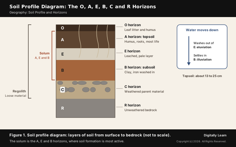
A soil profile is the vertical section of soil from the ground surface down to the parent rock. It is made up of layers called soil horizons, each lying roughly parallel to the surface and differing from the layers above and below in colour, texture and chemistry. Soil scientists name six master horizons, O, A, E, B, C and R, from the organic surface layer down to the bedrock, and call the A, E and B horizons together the solum, where soil formation is most active.
What Is Soil Profile? Soil Profile and Soil Horizon Meaning
Soil Profile Definition and Soil Horizons Meaning
Soil is the mixture of rock debris and organic materials that develops on the earth's surface. If a pit is dug into the ground, the soil is not the same all the way down: it changes in colour and feel from top to bottom. Each of these layers is a soil horizon, and the arrangement of layers is the soil profile.
A soil horizon is a layer parallel to the soil surface whose physical, chemical and biological characteristics differ from the layers above and beneath. Horizons are told apart mainly by colour and texture, and also by depth and chemical composition. A soil profile can be seen in the side of a freshly dug ditch or well, in the foundation pit of a building, at a road cutting on a hill or at a steep river bank.
How Many Layers of Soil: Three Horizons or Six Master Horizons
The number of layers depends on how finely they are divided. In the simplest account, a soil profile has three horizons resting on the bedrock:
- Horizon A: The topmost zone, where organic materials are mixed with the mineral matter, nutrients and water needed for plant growth.
- Horizon B: A transition zone between A and C that contains matter derived from below as well as from above; it has some organic matter, and its minerals are noticeably weathered.
- Horizon C: The loose parent material, the first stage of soil formation, which in time forms the two layers above.
- Bedrock: Beneath the three horizons lies the rock, also called the parent rock.
Soil scientists divide the profile further into master horizons, written as capital letters: O, A, E, B, C and R. Lowercase letters and figures added after them, called suffixes, describe the horizons in more detail. Not every soil has every horizon, and soils disturbed by deep ploughing or earthworks may lack distinct horizons almost completely.
Soil Profile Diagram: The Layers of Soil, O to R Horizons
O Horizon and A Horizon: Humus Layer and Topsoil
The O horizon is the organic surface layer, dominated by large amounts of organic matter in varying stages of decomposition, with at least 20 per cent organic carbon. Below the fresh leaf litter lies humus, the stable form of soil organic matter derived from decomposed plant and animal substances.
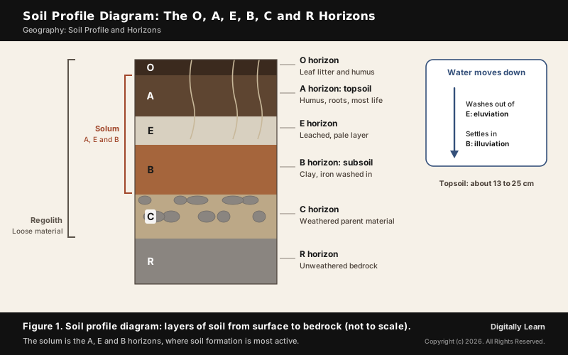
A soil horizon diagram such as Figure 1 stacks the layers in order, from the organic O horizon at the surface to the R horizon of bedrock. The A horizon is the top layer of mineral soil, commonly called topsoil, and it usually extends to a depth of about 13 to 25 cm. It is generally dark because it is rich in humus and minerals; it is soft, porous and holds more water. Most biological activity happens here: earthworms, fungi and bacteria crowd round the roots, and the roots of small plants lie entirely in the topsoil.
E Horizon and B Horizon: Leached Layer and Subsoil
The E horizon, short for eluviated, is a mineral horizon that has lost iron, aluminium, clay or organic matter by downward movement within the soil. What remains is a pale layer largely composed of silica. The loss happens because water percolating through the soil carries fine and dissolved material down with it.
The E horizon is clearest in a podzol, a soil of cool, wet forests. The name means under-ash in Russian: peasants ploughing such soil for the first time turned up what looked like a layer of ash, the bleached E horizon. The term was given in 1875 by Vasily Dokuchaev. Below it lies a red or red-brown horizon where the washed-down iron and humus collect. How rainwater strips a soil is covered in leaching of soil.
The B horizon, the subsoil, lies under the topsoil. It has much less organic matter and humus but more minerals, and it is generally harder and more compact. It is where material washed down from above gathers: clay, iron, aluminium, silica, humus, calcium carbonate or gypsum, depending on the climate.
- Accumulation: Clay and iron washed from the A and E horizons build up in B; this deposition is called illuviation.
- Colour: Iron oxides often colour the B horizon red or brown.
- Hardpan: Some subsoils develop a dense layer below the topsoil that is largely impervious to water.
- Transitional horizons: Where two master horizons blend, both letters are written, the dominant one first, as in AB or BA.
C Horizon and R Horizon: Parent Material and Bedrock
The C horizon is the parent material: unconsolidated earthy material with little or no change from soil formation, made up of small lumps of rock with cracks and crevices. It is the first stage of soil formation, and over time it weathers into the horizons above. Plant roots can reach into it.
The R horizon is the bedrock, strongly cemented and hard. All the loose material above it, from the soil at the surface down to the weathered rock, is the regolith; its uppermost part, rich in organic matter, is what is usually called soil.
| Horizon | Common name | What it contains |
|---|---|---|
| O | Organic layer | Leaf litter and humus |
| A | Topsoil | Humus mixed with minerals; roots and life |
| E | Leached layer | Pale silica after loss of clay, iron |
| B | Subsoil | Clay, iron, humus washed in from above |
| C | Parent material | Weathered rock, little soil formation |
| R | Bedrock | Hard, unweathered rock |
Solum in Soil Profile and Diagnostic Horizons
Solum in Soil Profile: The A, E and B Horizons
The solum is the A, E and B horizons taken together: the upper part of the profile where biological activity and climate drive soil formation. The layers below the solum, the C and R, have no collective name, but they are noticeably less affected by the soil-forming processes at the surface.
Solum and regolith are easy to confuse. The regolith is all the loose material above the bedrock, including the C horizon; the solum is only its upper, most altered part.
| Term | What it covers |
|---|---|
| Soil profile | The whole vertical section, surface to parent rock |
| Solum | The A, E and B horizons, where soil forms most actively |
| Regolith | All loose material above the bedrock, C horizon included |
| Topsoil | The A horizon, richest in humus and life |
Diagnostic Horizons and Soil Classification Systems
Horizons are also the basis of soil classification. Most systems use horizons to define soil types, and several pick out particular diagnostic horizons, identified by names such as the cambic or the spodic horizon. The World Reference Base for Soil Resources, the international standard endorsed by the International Union of Soil Sciences, lists 40 diagnostic horizons.
- World Reference Base: The international standard; it replaced the FAO/UNESCO legend for the Soil Map of the World.
- USDA soil taxonomy: Developed to interpret soil surveys; soils without a clear development of horizons are grouped as Entisols.
- No single correct system: Each system defines its symbols differently, so they cannot be mixed.
Classification groups soils with a similar range of properties into units that can be mapped. The Indian soil types, alluvial, black, red and laterite, arid, saline, peaty and forest soils, are each described in the Indian soils series.
How a Soil Profile Forms: Soil-Forming Factors and Processes
Factors of Soil Formation That Shape the Soil Profile
Soil forms slowly as weathering and gradation act on the parent rock. The major factors are relief, parent material, climate, vegetation and other life-forms, and time; human activities also influence soil to a large extent. The components of soil are mineral particles, humus, water and air, in amounts that differ from one soil to another.
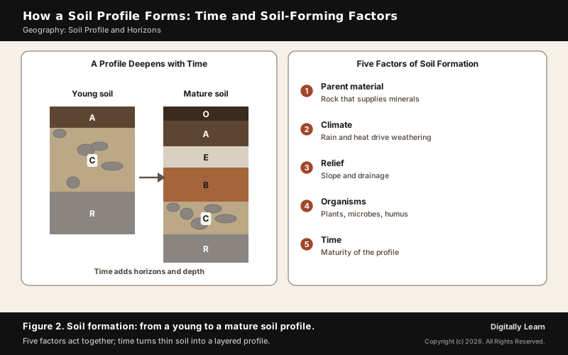
- Parent material: The rock that supplies the soil’s minerals and nearly all its plant nutrients.
- Climate: Water percolating deeper means deeper weathering and a deeper, more developed soil.
- Relief: The slope and height of the land.
- Organisms: Microbes feed on nutrients released by weathering and leave residues that form humus.
- Time as a factor: Time gives maturity to soils and helps soil profiles develop.
The factors act together; ordered as climate, organisms, relief, parent material and time they form the memory aid CLORPT. The full account of soil genesis is in genesis of soil.
Eluviation and Illuviation: How Soil Horizons Form
Horizons form because water moves material downward. Surplus water percolating through the soil profile carries soluble and suspended material, including clay particles and dissolved organic matter, from the upper layers to the lower ones. The removal from above is eluviation; the deposit below is illuviation, and the material deposited is illuvium.
Percolating water also speeds up weathering reactions and helps the horizons differentiate, so the amount of water moving through a soil shapes how clearly its horizons develop. In soil science, eluviation is also called leaching.
| Point | Eluviation | Illuviation |
|---|---|---|
| Meaning | Removal of material | Deposition of material |
| Horizon | A and especially E | B, the subsoil |
| Result | Pale, leached layer | Layer rich in clay, iron, humus |
| Moved by | Percolating rainwater | Percolating rainwater |
Soil Profiles in Different Climates: Podzol, Laterite, Rainforest
Climate decides which horizons grow thick. In cool, wet forests, a podzol develops a thick bleached E horizon over a red-brown B. In hot, wet regions, intensive and prolonged weathering makes laterite, a soil rich in iron and aluminium and nearly always rusty red from its iron oxide.
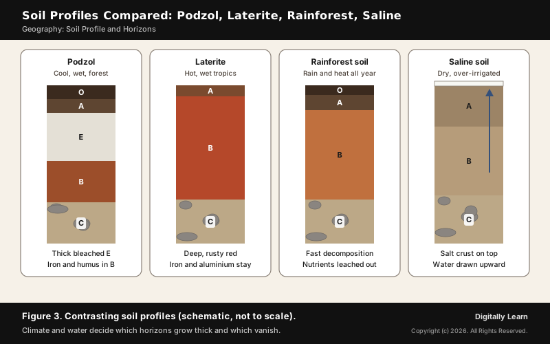
Tropical rainforests show that lush forest does not mean rich soil. Abundant rainfall produces nutrient-poor, leached soils, and high temperatures, moisture and abundant decomposers break down dead organic matter quickly. Laterite soils of India are covered in red and laterite soils.
- Peaty soils: In areas of heavy rainfall and high humidity with good growth of vegetation, dead organic matter piles up and gives the soil a rich humus content; organic matter may reach 40 to 50 per cent.
- Forest soils of the Himalaya: In snow-bound areas they are acidic with low humus content, while the soils of the lower valleys are fertile; see forest and mountain soils.
Why the Soil Profile Matters: Water, Fertility and Salinity
Soil Profile, Water Holding Capacity and Soil Fertility
The profile decides how much water a soil can hold. Sandy soils let water through quickly and stay light, well aerated and rather dry; clay soils hold water in the tiny gaps between their particles; loam, a mixture of sand, silt and clay with humus, has the right water holding capacity for plants. The rate at which water percolates is highest in sandy soil and lowest in clayey soil.
- Organic matter: Soil organic matter improves soil structure and water retention and stores plant nutrients, especially nitrogen, phosphorus and sulphur.
- Soil testing: India’s Soil Health Card reports 12 parameters: nitrogen, phosphorus, potassium and sulphur; zinc, iron, copper, manganese and boron; and pH, electrical conductivity and organic carbon.
- Soil moisture from space: NASA’s SMAP satellite, launched in January 2015, measures how much water is in the top layer of soil everywhere on earth.
Salinity in the Soil Profile: Irrigation and Capillary Action
Saline soils, also called Usara soils, contain a large share of sodium, potassium and magnesium, so they are infertile. They form in dry climates with poor drainage, in waterlogged and swampy areas, and where seawater intrudes into deltas, as in western Gujarat, the eastern deltas and the Sundarbans.
Irrigation can create them too. In areas of intensive cultivation with excessive irrigation, especially in the green revolution belt of Punjab and Haryana, fertile alluvial soils are becoming saline. Excessive irrigation in a dry climate promotes capillary action, which draws water up through the profile and leaves salt on the top layer of the soil. Farmers are advised to add gypsum to solve the problem.
Previous Year UPSC-CSE Questions
Previous Year UPSC-CSE Questions By the end you will be able to draft model answers for the following UPSC questions. Each question carries a collapsible framework showing how to approach it in the exam.
- UPSC Prelims 2018 Prelims-GSWith reference to agricultural soils, consider the following statements :
- A high content of organic matter in soil drastically reduces its water holding capacity.
- Soil does not play any role in the sulphur cycle.
- Irrigation over a period of time can contribute to the salinization of some agricultural lands.
Which of the statements given above is/are correct ?
How to approach this Prelims question
Approach: Test each statement against how the soil profile holds water, cycles nutrients and gathers salt.
Trap to watch: Organic matter raises water holding capacity; 'drastically reduces' is the trap.
Key facts to recall:
- (a) 1 and 2 only: wrong. Both are false: organic matter raises the water holding capacity of soil, and soil stores sulphur and takes part in its cycle.
- (b) 3 only: right. Under excessive irrigation, capillary action draws salty water up and leaves salt on the surface.
- (c) 1 and 3 only: wrong, since statement 1 is false.
- (d) 1, 2 and 3: wrong, since statements 1 and 2 are false.
Answer signal: Statement 3 only, option (b).
- UPSC Prelims 2023 Prelims-GSConsider the following statements :
- Statement-I : The soil in tropical rain forests is rich in nutrients.
- Statement-II : The high temperature and moisture of tropical rain forests cause dead organic matter in the soil to decompose quickly.
Which one of the following is correct in respect of the above statements?
How to approach this Prelims question
Approach: Judge each statement on its own, then check whether II explains I.
Trap to watch: Lush forest suggests fertile soil; the soil itself is leached and poor.
Key facts to recall:
- (a) Both correct, II explains I: wrong. Statement I is incorrect: heavy rain leaches rain-forest soil and leaves it poor in nutrients.
- (b) Both correct, II does not explain I: wrong, for the same reason.
- (c) I correct, II incorrect: wrong. It is the other way round.
- (d) I incorrect, II correct: right. The soil is leached and poor, while heat and moisture decompose dead organic matter quickly.
Answer signal: Statement I incorrect, Statement II correct, option (d).
Sources
- NCERT: India Physical Environment (Class XI), Soils
- NCERT: Fundamentals of Physical Geography (Class XI), Geography as a Discipline
- NCERT: Science (Class VII), Soil
- FAO: World Soil Day
- FAO Soils Portal: Soil classification
- FAO Soils Portal: World Reference Base
- PIB (Ministry of Agriculture and Farmers Welfare): Celebrating a Decade of Soil Health Cards, 2025
- NASA JPL: SMAP mission description
- Wikipedia: Soil horizon
- Wikipedia: Pedogenesis
- Wikipedia: Humus
- Wikipedia: Topsoil
- Wikipedia: Subsoil
- Wikipedia: Eluvium
- Wikipedia: Illuvium
- Wikipedia: Hardpan
- Wikipedia: Regolith
- Wikipedia: Podzol
- Wikipedia: Laterite
- Wikipedia: Tropical rainforest
- Wikipedia: Soil organic matter
- Wikipedia: Soil salinity
- UPSC: Civil Services Examination question papers
Editorial Disclaimer
This article draws on the NCERT geography and science textbooks, FAO, the Press Information Bureau, NASA and the other sources listed on this page. Diagrams are schematic and not drawn to scale.


