


Overview
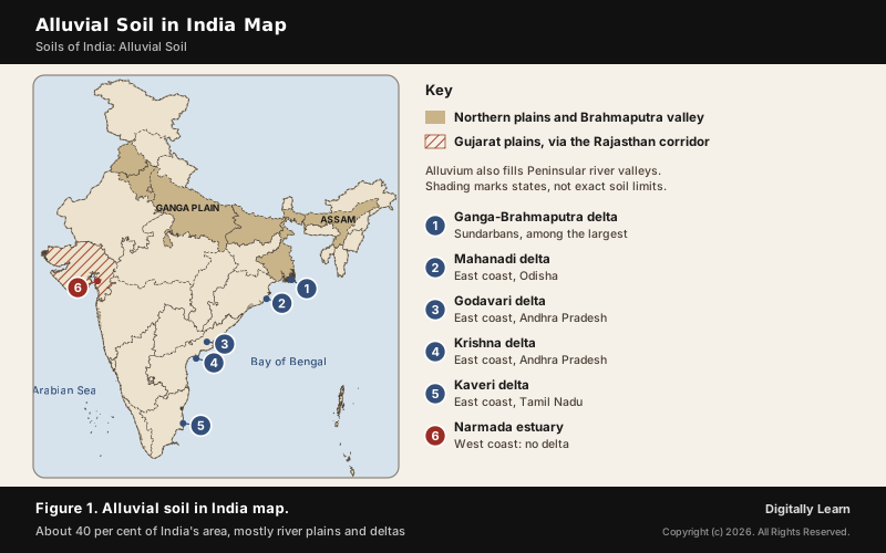
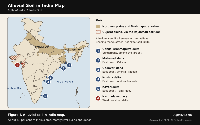
Alluvial soil is soil formed from alluvium, the loose sand, silt and clay laid down by rivers. It covers about 40 per cent of India, the whole of the northern plains, the Brahmaputra valley and the deltas of the east coast. By age it is divided into khadar, the new alluvium of the floodplains renewed by floods almost every year, and bhangar, the older alluvium on higher terraces that floods no longer reach.
Alluvial Soil: Meaning, Formation and Where It Is Found
What Is Alluvial Soil?
Alluvial soil develops on alluvium: loose clay, silt, sand or gravel deposited by running water in stream beds, on floodplains and in alluvial fans. The word comes from the Latin alluere, to wash against. Alluvium is geologically young and not consolidated into rock, which is why these soils are called azonal: younger, transported soils rather than soils weathered in place.
It is the most widely spread and important soil of India. The entire northern plains are made of it, and FAO's world classification counts the Ganges plain and the Ganga-Brahmaputra delta among the world's major concentrations of alluvial soils, which it names Fluvisols.
How Is Alluvial Soil Formed? The Himalayan Rivers and the Plains
Alluvial soils are formed by the deposition of sand, silt and clay in layers. In India most of it was laid down by three Himalayan river systems, the Indus, the Ganga and the Brahmaputra. Their plains run for about 3,200 km from east to west, 150 to 300 km wide, and the alluvium beneath them reaches a maximum depth of 1,000 to 2,000 m.
Particle size changes along the way. Moving inland towards the upper river valleys the particles become bigger, and near the break of slope at the foot of the mountains the soils are coarse, as in the piedmont plains of the Duars, Chos and Terai. From west to east across the Ganga plain the sand content falls, and the soils of the lower and middle Ganga plain and the Brahmaputra valley are more loamy and clayey.
The plain itself began as a trough. The Indo-Ganga-Brahmaputra plain was originally a geosynclinal depression that the three river systems filled with sediment, which is why its alluvium is so deep. The Brahmaputra carries little silt in dry Tibet, but in India it crosses a region of high rainfall and carries a large volume of water and a considerable amount of silt.
Where Is Alluvial Soil Found in India? Map and States
Alluvial soils are widespread in the northern plains and the river valleys. Through a narrow corridor in Rajasthan they extend into the plains of Gujarat, and in the Peninsula they are found in the deltas of the east coast and in the river valleys. The Brahmaputra valley in Assam is alluvial too.
The plains carry the landforms of a mature river: sand bars, meanders, ox-bow lakes and braided channels. The Brahmaputra plains are known for their riverine islands and sand bars, and much of this land is flooded periodically as the rivers shift course and braid. Otherwise it is a featureless plain, 50 to 150 m above mean sea level.
| Region | Where |
|---|---|
| Northern plains | Punjab, Haryana, Delhi, Uttar Pradesh, Bihar, West Bengal |
| Brahmaputra valley | Assam |
| Western corridor | Through Rajasthan into the plains of Gujarat |
| East coast deltas | Mahanadi, Godavari, Krishna and Kaveri |
| Peninsular valleys | Along the rivers of the plateau |
Khadar and Bhangar: Difference Between New and Old Alluvium
Difference Between Khadar and Bhangar
By age, alluvial soil is divided into two. Khadar is the new alluvium, deposited by floods almost every year, which keeps enriching it with fine silt. Bhangar is the older alluvium, deposited away from the present floodplains and lying above them as a terrace that floodwater cannot reach.
| Point | Khadar | Bhangar |
|---|---|---|
| Age | New alluvium | Old alluvium |
| Position | Low floodplain beside the river | Higher terrace above the floodplain |
| Flooding | Flooded and renewed almost every year | Beyond the reach of floods |
| Kankar | Less | More; beds of kankar a few metres down |
| Texture | More fine particles | Fewer fine particles; calcareous nodules |
| Fertility | More fertile; intensive farming | Less fertile |
| Local names | Nali (Ghaggar), bet (Markanda) | Nardak, where kankar lies deep |
Kankar is nodular calcium carbonate that forms in soils of semi-arid regions; it is used to make lime and roads. In Haryana's bhangar the nodules range from less than 1 cm to more than 5 cm across, and where they lie well below the root zone the land is called nardak.
Bhabar, Terai, Bhangar and Khadar: Belts of the Northern Plains
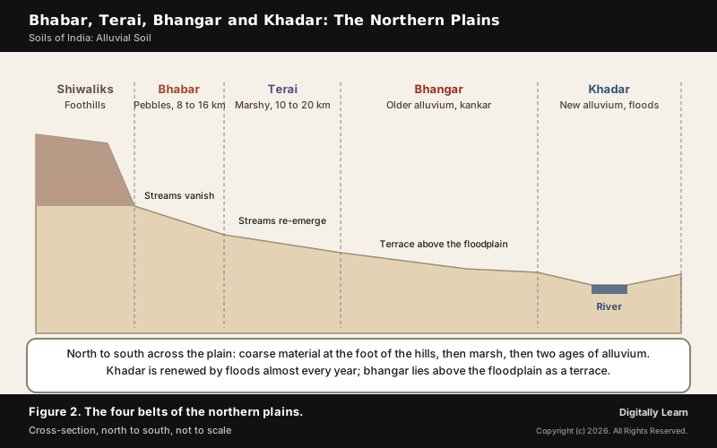
From the Shiwalik foothills southwards, the northern plains fall into four belts, and only the last two are the alluvial plain proper:
- Bhabar: A narrow belt of pebbles and boulders at the break of slope, 8 to 16 km wide in NCERT Class IX (8 to 10 km in Class XI), where the streams disappear.
- Terai: South of the bhabar, 10 to 20 km wide, where the streams re-emerge without proper channels and create marshy, swampy land; once thickly forested, it was cleared for farming and for migrants after Partition.
- Bhangar: The largest part of the plain, older alluvium forming terraces above the floodplains.
- Khadar: The younger floodplain deposits, renewed almost every year and ideal for intensive agriculture.
Soils change with the belts. The bhabar soil is sandy, highly porous and holds little moisture, while terai soils are rich in nitrogen and organic matter. The Ganga plains also have local alluvial variants: bhur, a sandy soil of the Ramganga tract, and bhat, a whitish calcareous soil of the lower Gandak valley.
Khadar and Bangar in the Doabs of the Ganga Plain
The Himalayan rivers divide the plains into doabs, the tracts between two rivers. Each doab alternates between river, khadar and bangar: low-lying, usually very fertile khadar near the rivers, and higher bangar away from them, less prone to flooding but also less fertile on average. The best known is the Ganga-Yamuna Doab, the flat alluvial tract between the two rivers from the Shiwalik Hills to their confluence at Prayagraj.
The difference mattered enough to be taxed. For centuries villages in the doabs were officially classed as khadir, khadir-bangar (mixed) or bangar, with different agricultural tax rates on a scale of land productivity. On the Yamuna near Faridabad the khadar is generally 3 to 5 km wide; when floods recede they leave fine silt that is easy to plough, and the soil keeps its moisture after the rains.
Haryana shows how many local names one alluvial plain can carry. Its Ghaggar-Yamuna plain, below 300 m, is made up of bangar, khadar, naili and bet. Within it the narrow, low-lying floodplains are the khadar of the Yamuna, the nali of the Ghaggar and the bet of the Markanda, while the older bangar is covered by Pleistocene deposits with kankar at varying depths.
Characteristics of Alluvial Soil and Its Crops
Characteristics of Alluvial Soil: Texture, Colour and Nutrients
The main characteristics of alluvial soil:
- Texture: Varies from sandy loam to clay, in various proportions of sand, silt and clay.
- Colour: Light grey to ash grey; the shade depends on the depth of deposition, the texture and the time taken to mature.
- Nutrients: Generally rich in potash; Class XI calls it poor in phosphorus, while Class X says most alluvial soils have adequate potash, phosphoric acid and lime.
- Profile: Young and layered, with weak horizons, as FAO describes for soils in alluvial deposits.
- Alkalinity: Soils in drier areas are more alkaline, but can be productive after proper treatment and irrigation.
As a whole, alluvial soils are very fertile, and the khadar more so than the bhangar. Their weak point is the same as their strength: being loose and young, they depend on the river, so flood control, drainage or irrigation are usually needed to farm them well.
Other classifications use other names for the same soils. FAO calls them Fluvisols and notes that the USDA Soil Taxonomy calls them Fluvents. In Faridabad district on the Yamuna, the National Bureau of Soil Survey and Land Use Planning classifies the soils as aquents-fluvents and ochrepts, with loam on the bhangar and silty loam on the khadar.
Alluvial Soil Crops and the Densely Populated Plains
Alluvial soils are ideal for sugarcane, paddy, wheat and other cereal and pulse crops. Because they are so fertile, the regions of alluvial soil are intensively cultivated and densely populated.
- Drier west: Wheat, barley and millet are the main crops of the western plain.
- Wetter east: Rice predominates in the wetter eastern and northern parts.
- Khadar floodplains: Renewed silt makes it ideal for intensive agriculture.
The scale is striking. The Indo-Gangetic Plain spans about 700,000 square km across northern South Asia and holds the world's largest expanse of uninterrupted alluvium. It is home to nearly one-seventh of the world's population and is one of the most densely populated and intensely farmed regions on Earth.
That fertility shaped history. The fertile terrain of the plain helped the rise and spread of empires such as the Mauryas, the Kushans and the Guptas, all of which had their demographic and political centres in the Indo-Gangetic plain. The same alluvium carried the Green Revolution and today carries its salinity problem.
Salinity in the Alluvial Plains: Irrigation, Gypsum and Deltas
Fertile alluvium can be spoiled. In areas of intensive cultivation with excessive irrigation, especially the Green Revolution areas, the fertile alluvial soils are becoming saline. The mechanism is simple: excessive irrigation under a dry climate promotes capillary action, which brings salt up and deposits it on the top layer of the soil.
- Where: Irrigated canal command tracts, especially in Punjab and Haryana, where salts form a white crust that is unfavourable for plant growth.
- Remedy: Farmers in such areas are advised to add gypsum to correct salinity.
- Deltas: Seawater intrusion makes saline soils common in the deltas of the east coast and the Sundarbans.
Difference Between Alluvial Soil and Black Soil
Black soil, the soil of the Deccan lava plateau, is the usual comparison. Alluvial soil is transported by rivers; black soil forms in place from basalt and is known for holding moisture.
The two also behave differently with water. Black soil is clayey and impermeable, swells when wet, cracks when dry and retains moisture for a long time, which helps rain-fed crops through the dry season. Alluvial soil depends on the river instead: the khadar is renewed by floods, and the plains are farmed with canal and tubewell irrigation.
| Point | Alluvial soil | Black soil |
|---|---|---|
| Formed by | River deposition | Weathering of basalt (lava) |
| Where | Northern plains, deltas, valleys | Deccan Plateau |
| Texture | Sandy loam to clay | Clayey, deep, impermeable |
| Colour | Light grey to ash grey | Deep black to grey |
| Rich in | Potash | Lime, iron, magnesia, alumina, potash |
| Main crops | Wheat, rice, sugarcane, pulses | Cotton |
Deltaic Alluvium: East Coast Deltas and West Coast Estuaries
Delta Soils of the East Coast
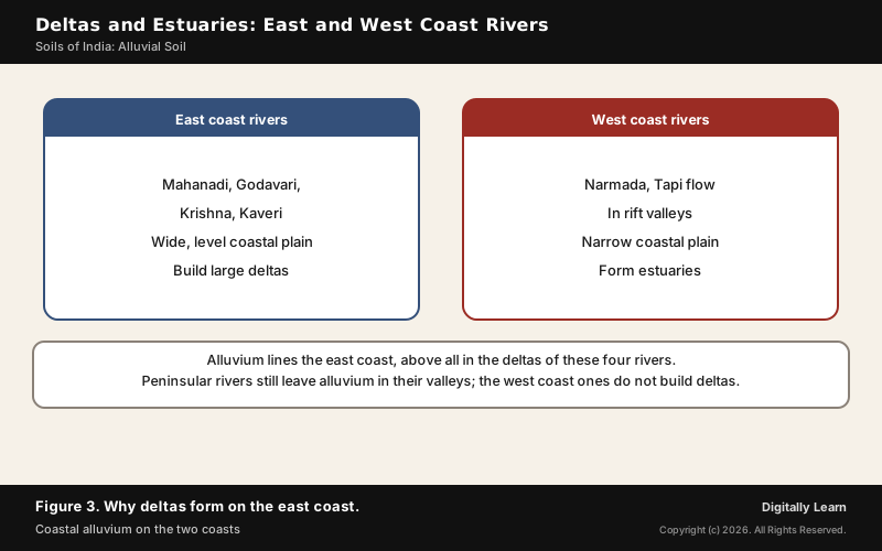
Alluvial soil is also found in the eastern coastal plains, particularly in the deltas of the Mahanadi, the Godavari, the Krishna and the Kaveri. The plain along the Bay of Bengal is wide and level, and these large rivers have formed extensive deltas on it. Where the Ganga and the Brahmaputra meet the sea they form one of the largest deltas in the world, the Sundarbans.
Delta soils are rich but exposed. The Sundarbans, in the delta of the Ganges, Brahmaputra and Meghna, spread over 10,277 square km and form the world's largest mangrove forest, cut by tidal streams and channels. The thickly populated deltas of the Godavari, Krishna and Kaveri are the preferred targets of the tropical cyclones that strike the east coast, and seawater intrusion can turn delta soils saline.
Why West Coast Rivers Form No Deltas
The rivers flowing into the Arabian Sea build no deltas, for two reasons in the land itself:
- A narrow coastal plain: The plain between the Western Ghats and the Arabian Sea is very narrow, so the coastal rivers are short.
- Rift valleys: The Narmada and the Tapi flow in rift valleys, and rift valley rivers form estuaries rather than deltas; the Narmada meets the sea south of Bharuch in a broad estuary.
That does not mean these rivers carry no alluvium. Alluvial soils are found in the river valleys of the Peninsula, and the high banks of the lower Narmada are made of layers of old alluvial deposits, hardened mud, gravel of nodular limestone and sand.
Previous Year UPSC-CSE Questions
Previous Year UPSC-CSE Questions By the end you will be able to draft model answers for the following UPSC questions. Each question carries a collapsible framework showing how to approach it in the exam.
- UPSC Mains 2013 GS-IThere is no formation of deltas by rivers of the Western Ghat. Why?
Answer outline: how to structure the answer
What the question asks, the main arguments, relevant examples and the direction of the conclusion. This is not a full model answer.
Introduction: East coast rivers build large deltas; the rivers of the Western Ghats reach the Arabian Sea through estuaries.
Body (sub-themes to develop):
- Narrow coastal plain between the Ghats and the sea: short rivers.
- Narmada and Tapi flow in rift valleys; rift valley rivers form estuaries.
- Contrast: the wide, level east coast plain with the Mahanadi, Godavari, Krishna and Kaveri deltas.
- Alluvium still lines the west coast valleys; the difference is the delta, not the sediment.
Conclusion: Conclude that relief and structure, not a lack of sediment, decide where deltas form.
- UPSC Prelims 2010 Prelims-GSIf there were no Himalayan ranges, what would have been the most likely geographical impact on India?
- Much of the country would experience the cold waves from Siberia.
- Indo-Gangetic plain would be devoid of such extensive alluvial soils.
- The pattern of monsoon would be different from what it is at present.
Which of the statements given above is/are correct?
How to approach this Prelims question
Approach: Test each statement against one job the Himalaya does for India. Statement 1: the Himalayas prevent the extremely cold winds from Central Asia from entering the subcontinent, so without them the cold waves would reach much of the country. Statement 2: the Indus, Ganga and Brahmaputra carry Himalayan sediment that built the alluvium of the plain, up to 1,000 to 2,000 m deep. Statement 3: the monsoon's timing is tied to the subtropical westerly jet stream moving north of the Himalayas in summer, so without the range the monsoon pattern would change. All three hold.
Trap to watch: All three are true; the alluvium statement is the one this page teaches.
Key facts to recall:
- (a) 1 only: wrong. It leaves out the alluvium and the monsoon, both of which depend on the Himalaya.
- (b) 1 and 3 only: wrong. It leaves out statement 2, the one this page teaches: the Himalayan rivers supply the sediment of the Indo-Gangetic plain.
- (c) 2 and 3 only: wrong. It leaves out statement 1: the Himalayas keep the cold winds of Central Asia out.
- (d) 1, 2 and 3: right. The range blocks cold winds, feeds the rivers that laid the alluvium and shapes the monsoon.
Answer signal: All three statements hold, so option (d) is the answer.
- UPSC Prelims 2004 Prelims-GSAssertion (A): West-flowing rivers of Peninsular India have no deltas. Reason (R): These rivers do not carry any alluvial sediment.
How to approach this Prelims question
Approach: Accept the Assertion, then test the Reason. West-flowing rivers of the Western Ghats cross a narrow coastal plain as short rivers, and the Narmada and Tapi flow in rift valleys, so they end in estuaries, not deltas: A is true. But these rivers do carry sediment, and alluvium still lines the west coast valleys: R is false. Relief and structure, not a lack of sediment, decide where deltas form.
Trap to watch: No deltas does not mean no sediment; relief and rift valleys decide.
Key facts to recall:
- (a) Both true, R explains A: wrong. R is false: the rivers carry alluvial sediment.
- (b) Both true, R does not explain A: wrong. R is still false.
- (c) A true, R false: right. No deltas, because of short rivers on a narrow plain and rift-valley estuaries, but the sediment is there.
- (d) A false, R true: wrong. A is true: the west-flowing rivers form estuaries rather than deltas.
Answer signal: A is true and R is false, so option (c) is the answer.
Sources and Further Reading
- NCERT: Contemporary India I (Class IX), Physical Features of India
- NCERT: Contemporary India II (Class X), Resources and Development
- NCERT: India Physical Environment (Class XI), Structure and Physiography; Soils
- FAO: Lecture Notes on the Major Soils of the World, Fluvisols
- NATMO (National Atlas and Thematic Mapping Organisation): Soils
- Government of Haryana: Geography
- District Faridabad, Government of Haryana: About District
- Wikipedia: Alluvium
- Wikipedia: Indo-Gangetic Plain
- Wikipedia: Doab
- Wikipedia: Kankar
- Wikipedia: Narmada River
- UPSC: Previous year question papers
Editorial Disclaimer
This article is compiled from the reference materials listed in the Sources section. It is an explainer for UPSC preparation and is not a substitute for primary documents (NCERTs, GoI ministry releases, IMD bulletins, RBI / CEA / MoEFCC publications, and Standing-Committee reports).