
Overview
Differential heating, the ITCZ, jet streams, and the ENSO-IOD-MJO drivers
How the south-west monsoon forms: land-sea heating, the ITCZ and monsoon trough, Coriolis-turned cross-equatorial winds, the jet-stream switch, and the planetary drivers that make each year wetter or drier.
Previous Year UPSC-CSE Questions By the end you will be able to draft model answers for the following UPSC questions. Each question carries a collapsible framework showing how to approach it in the exam.
- UPSC Prelims 2010 General StudiesIf there were no Himalayan ranges, what would have been the most likely geographical impact on India?
- Much of the country would experience the cold waves from Siberia.
- Indo-Gangetic plain would be devoid of such extensive alluvial soils.
- The pattern of monsoon would be different from what it is at present.
Which of the statements given above is/are correct?
How to approach this Prelims question
Approach: A hypothetical counterfactual on Himalayan-monsoon coupling. Three independent geographical claims must be evaluated. Each rests on a distinct mechanism: cold-air blocking (Statement 1), foreland-basin alluvium genesis (Statement 2), and monsoon coupling (Statement 3).
Trap to watch: Aspirants may doubt Statement 1 on grounds that Siberia is too far away; the trap is that air-mass intrusion pathways are blocked by the Himalayan wall regardless of source distance. Doubt on Statement 2 (assuming peninsular India would still have alluvium) misses that peninsular rivers carry Deccan-Trap-derived sediment, not Himalayan alluvium.
Key facts to recall:
- Cold-wave blocking: Himalayas block Central Asian and Siberian continental air masses; without them, Indo-Gangetic winter temperatures would fall 10-15 C.
- Alluvial origin: Indo-Gangetic alluvium derives from Himalayan rivers (Indus, Ganga, Brahmaputra); foreland-basin geometry is a Himalayan-orogeny consequence.
- Monsoon dependence: Himalayan barrier bottles monsoon flow; releases orographic rainfall; excludes dry Central Asian air.
Answer signal: (d) 1, 2 and 3
- UPSC Prelims 2011 General StudiesLa Nina is suspected to have caused recent floods in Australia. How is La Nina different from El Nino ?
- La Nina is characterised by unusually cold ocean temperature in equatorial Indian Ocean whereas El Nino is characterised by unusually warm ocean temperature in the equatorial Pacific Ocean.
- El Nino has adverse effect on south-west monsoon of India, but La Nina has no effect on monsoon climate.
Which of the statements given above is/are correct ?
How to approach this Prelims question
Approach: Statement 1 reverses the geography of La Nina; La Nina is a Pacific phenomenon not an Indian Ocean phenomenon. Statement 2 is also wrong; La Nina is associated with above-normal Indian monsoon, not a no-effect condition. Both statements wrong.
Trap to watch: Both statements sound plausible if you don't know that La Nina is Pacific-based and that La Nina is monsoon-favourable.
Key facts to recall:
- La Nina is equatorial Pacific SST cooling, the opposite phase of El Nino
- La Nina strengthens the Indian monsoon through enhanced Walker Circulation
- El Nino is equatorial Pacific SST warming, weakens Indian monsoon
Answer signal: Both statements wrong; option Neither 1 nor 2.
- UPSC Prelims 2010 General StudiesA new type of El Nino called El Nino Modoki appeared in the news. In this context, consider the following statements:
- Normal El Nino forms in the Central Pacific ocean whereas El Nino Modoki forms in Eastern Pacific ocean.
- Normal El Nino results in diminished hurricanes in the Atlantic ocean but El Nino Modoki results in a greater number of hurricanes with greater frequency.
Which of the statements given above is/are correct?
How to approach this Prelims question
Approach: Statement 1 reverses geography: normal El Nino forms in the Eastern Pacific off the Peruvian coast; El Nino Modoki forms in the Central Pacific. Statement 2 is correct: Modoki is associated with greater Atlantic hurricane activity.
Trap to watch: Test-takers often mis-locate normal El Nino as Central Pacific because Modoki is a newer concept.
Key facts to recall:
- Normal El Nino forms in the Eastern Pacific off Peru-Ecuador coast
- El Nino Modoki forms in the Central Pacific around the date line
- Modoki has different atmospheric circulation impacts than classical El Nino
Answer signal: Only statement 2 correct; option 2 only.
The Indian Monsoon is a large-scale seasonal reversal of wind direction that delivers approximately 75 per cent of India's annual rainfall in a four-month window from June to September. The system is driven by the seasonal migration of the Inter-Tropical Convergence Zone, the differential heating of the Asian landmass and the surrounding ocean, and the Coriolis deflection of cross-equatorial flow. The Indian Monsoon is one branch of a global tropical monsoon system that includes the West African, Australian, and Southeast Asian monsoons. Modern climate science classifies it as a coupled ocean-atmosphere phenomenon, embedded within the Walker circulation and modulated by the El Nino Southern Oscillation, the Indian Ocean Dipole, and the Madden Julian Oscillation. The system has two principal branches at the Indian coast: the Arabian Sea branch and the Bay of Bengal branch.
Background and Historical Context
The Indian Monsoon underwrites the entire kharif cropping cycle, the country's reservoir replenishment, and the hydrological budget of the Ganga, Brahmaputra, and peninsular river systems. The June-to-September long-period average (LPA) of all-India rainfall, as set by the India Meteorological Department's 1971-2020 reference series, is 868 millimetres; a 10 per cent deviation in either direction reshapes food-grain output, electricity demand from agriculture, and rural wages. UPSC Prelims questions on the monsoon have appeared almost every year, testing the duration gradient, the rainfall gradient, the Coriolis mechanism, the ENSO link, and the regional rainshadow effects. UPSC GS-I Mains questions on physical geography and GS-III questions on disaster management and agriculture anchor heavily on monsoon-driven phenomena.
What is the significance of mastering the monsoon mechanism? The mechanism explains
- (a) why southern India receives the monsoon earlier than northern India.
- (b) why the Western Ghats windward slopes receive 2,500 to 6,000 mm while the Deccan rainshadow receives 500 to 750 mm.
- (c) why the eastern coast receives a winter monsoon from the retreating north-east trades, and.
- (d) why a strong El Nino in the equatorial Pacific can suppress Indian summer monsoon rainfall by 5 to 15 per cent below normal.
Without this conceptual foundation, students cannot reason through the regional-variation or contemporary-disaster questions that dominate the modern UPSC pattern.
The India Meteorological Department issues operational long-range forecasts using a multi-model coupled-ocean-atmosphere ensemble under the Monsoon Mission framework launched in 2012. The Mission Mausam initiative announced in 2024 commits Rs 2,000 crore for an expanded observation network, including additional radars, ocean buoys, and a denser automatic-weather-station grid. Climate-change projections from the IPCC Sixth Assessment Report indicate a 14 per cent increase in monsoon precipitation intensity per degree of warming by mid-century, with disproportionate increases in extreme events. Part 1 establishes the foundational mechanism; Parts 2 and 3 build on it to address regional variation and the climate-change frontier.
Introduction: What is a Monsoon, Etymology, and the Global Tropical Monsoon System
Definition by the seasonal-wind-reversal criterion and the Arabic etymology
Definition, etymology, and the seasonal-reversal criterion
A monsoon is a seasonal reversal of the prevailing wind direction across a tropical or sub-tropical region, accompanied by a marked seasonal shift between a wet phase and a dry phase. The word derives from the Arabic mausim, meaning season, used by Arab traders who navigated the Arabian Sea between the Indian and East African coasts.
The defining criterion, set out by Khromov in 1957 and refined by Ramage in 1971, is that the prevailing wind direction must rotate by at least 120 degrees between January and July, the mean resultant wind in at least one month must exceed 3 metres per second, and the steadiness factor must exceed 40 per cent in both seasons.
The seasonal-reversal definition separates monsoon climates from trade-wind, westerly, and equatorial-doldrum climates. It places the Indian monsoon alongside the West African, Australian, and East Asian monsoons in one global framework. The monsoon is not merely a rainy season; it is a wind-system reversal driven by planetary-scale circulation, which is why the modulators (ENSO, IOD, MJO) act on all monsoon branches at once.
Tropical monsoon climates worldwide
The global tropical monsoon system arises because the entire tropical landmass-ocean configuration creates differential heating that the ITCZ tracks seasonally.
| Monsoon system | Spatial extent | Primary moisture source | Dominant driver |
|---|---|---|---|
| South Asian (Indian) | Indian subcontinent and Bangladesh and Myanmar | Indian Ocean (Arabian Sea and Bay of Bengal) | Tibetan Plateau heat source and ITCZ shift and Himalayan barrier |
| East Asian | China and Korea and Japan and Taiwan | Western Pacific and South China Sea | Continental Asia thermal low and western Pacific subtropical high |
| West African | Sahel belt and Guinea coast | Equatorial Atlantic and Gulf of Guinea | Saharan thermal low and ITCZ northward shift |
| Australian-Maritime | Northern Australia and Indonesian archipelago | Indian Ocean and western Pacific | Southern-hemisphere summer and cross-equatorial flow from Asian winter monsoon |
Mechanism Part 1: Differential Heating, ITCZ Migration, and Coriolis Deflection
Differential heating of the Asian landmass and the Indian Ocean
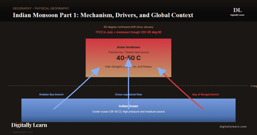
Differential heating of land and sea is the foundational mechanism of the Indian monsoon. India is flanked by the Indian Ocean on three sides and walled by mountains in the north. Water heats and cools slowly because of its high specific heat capacity, while the continental landmass heats faster in summer and cools faster in winter. This contrast produces sharply different pressure zones by season, and the pressure difference drives the seasonal reversal of the monsoon winds.
In April and May, when the sun is vertical over the Tropic of Cancer, the Asian landmass heats intensely and an intense low-pressure cell forms over the north-western subcontinent. The Indian Ocean stays cooler, with relatively higher pressure, so the land low draws the south-east trade winds across the Equator. That cross-equatorial crossing is the immediate precursor to the south-west monsoon.
The south-east trades cross the Equator between 40 degrees East and 60 degrees East longitudes. After crossing they undergo Coriolis deflection to the right and turn from a south-easterly into a south-westerly direction. This deflected current is what is popularly known as the south-west monsoon. The deflection mechanism is what gives the monsoon its name and its identity as the moist air current carrying ocean-derived precipitation to the Indian subcontinent.
- Land-sea heat capacity asymmetry: Water specific heat approximately 4.18 kJ per kg per degree Celsius; land specific heat roughly one-quarter of that.
- Summer pressure gradient: Intense low pressure over north-western India; relatively higher pressure over Indian Ocean.
- Wind crossing zone: South-east trades cross the Equator between 40 degrees East and 60 degrees East longitudes.
- Coriolis deflection: Crossing winds deflect to the right in the northern hemisphere and become south-westerly.
- Winter reversal: Land cools faster; high pressure builds over Central Asia; dry north-east winds flow outward toward the warmer southern oceans.
Inter-Tropical Convergence Zone seasonal migration
The Inter-Tropical Convergence Zone (ITCZ) is the near-equatorial low-pressure belt where the trade winds of the two hemispheres converge. Converging winds force air upward, so the ITCZ is a zone of ascending air, condensation, and heavy rainfall. Its position migrates with the apparent solar motion, shifting north toward the Tropic of Cancer and south toward the Tropic of Capricorn through the year.
In July the ITCZ lies around 20 to 25 degrees North over the Gangetic plain, where it is called the monsoon trough. The trough sustains a thermal low over north-west India that powers the south-west monsoon. The northward shift also redirects the southern-hemisphere trades: they cross the equator between 40 and 60 degrees East and turn south-westerly under Coriolis deflection. In winter the ITCZ moves south and the reversal flips, producing the north-east monsoon over peninsular India.
The ITCZ shift is coupled to the withdrawal of the subtropical westerly jet from south of the Himalayas. As that jet retreats north in early summer, the tropical easterly jet establishes near 15 degrees North, and its onset triggers the burst of the monsoon over Kerala. The two upper-tropospheric jets act as a switch: onset cannot occur until the pattern flips from winter to summer.
- July ITCZ position: 20-25 degrees North over Indo-Gangetic plain; called the monsoon trough.
- Coupling with jet streams: Northward ITCZ shift correlates with westerly jet withdrawal and tropical easterly jet establishment at 15 degrees North.
- Burst trigger: The establishment of the easterly jet at 15 degrees North releases the monsoon burst over Kerala.
- Winter retreat: ITCZ moves south of the equator; wind reversal produces the north-east monsoon over the Coromandel coast.
Coriolis force and the south-westerly direction
The pressure gradient alone would drive air northward along a straight path. The Coriolis force, the apparent deflection from the Earth's rotation, bends this cross-equatorial flow to the right in the northern hemisphere. The southern-hemisphere south-easterly trades, after crossing the equator, are turned to a south-westerly direction. That is why the Indian summer monsoon is the south-west monsoon, not a south or south-east monsoon.
The deflection magnitude is set by the Coriolis parameter, which is zero at the equator and grows with latitude. Cross-equatorial flow feels almost no deflection within 5 degrees of the equator, then strong deflection between 10 and 20 degrees. This is why the monsoon flow runs nearly north-bound near the equator yet arrives fully south-westerly at the Indian coast.
The Somali Jet, a low-level wind system that develops along the East African coast from May, channels the cross-equatorial flow into a narrow ribbon that accelerates to 30 to 40 metres per second at 850 hectopascals, delivering the bulk of the monsoon's moisture into the Arabian Sea.
- Deflection to the right: In the northern hemisphere converts the southern-hemisphere south-easterly trades into the Indian south-westerlies after they cross the equator.
- Somali Jet: Low-level cross-equatorial wind system accelerates to 30-40 m/s along the East African coast at 850 hPa, channelling moisture toward the Arabian Sea.
- Tropical Easterly Jet (TEJ): Upper-tropospheric flow at 150-200 hPa originates over Southeast Asia and flows westward across India to East Africa; its position and intensity correlate with monsoon vigour.
- Sub-tropical Westerly Jet (STWJ): Retreats north of the Himalayas in summer; its return south of the Himalayas in autumn signals the monsoon withdrawal.
Mechanism Part 2: Pre-monsoon Dynamics, Onset over Kerala, and the Two Branches
Mango showers, Kalbaisakhi Norwesters, and the Loo: April-May atmospheric preconditioning
The two months before the monsoon onset, April and May, are not merely the dry hot phase. They build the thermal contrast that drives the monsoon and produce the regional pre-monsoon storm systems that pre-condition surface moisture, cool the lower troposphere, and launch the onset.
Three pre-monsoon phenomena carry UPSC weight, each tied to a specific regional expression of the developing land-sea thermal contrast.
- Mango showers: Coastal Karnataka and Kerala in April, convective cells over the Arabian Sea; advance the ripening of mango and coffee crops.
- Kalbaisakhi (Norwesters): West Bengal, Odisha, Jharkhand, Bihar, and Assam in March-May; produced by collision of moist Bay-of-Bengal air with dry continental air; intense short-duration thunderstorms with hail.
- Loo: Hot dry continental wind over the Indo-Gangetic plain in May; integral part of the heat-low formation that drives the monsoon.
Monsoon onset over Kerala and the Arabian Sea and Bay of Bengal branches
The official monsoon onset over Kerala (MOK) is declared by the India Meteorological Department when three operational criteria are met simultaneously.
- Rainfall criterion: At least 60 per cent of the 14 designated stations in Kerala and coastal Karnataka must record 2.5 mm or more on two consecutive days.
- Wind criterion: Westerly wind speed of 15 to 20 knots at 850 hPa must extend from the equator to 10 degrees north between 55 and 80 degrees east.
- Cloud criterion: Outgoing longwave radiation at the top of the atmosphere must fall below 200 watts per square metre over the south-eastern Arabian Sea, indicating deep convective cloud.
- Onset calendar: Long-period average MOK date is 1 June; earliest on record 11 May (1990); latest 18 June (1972).
The long-period average MOK date is 1 June. The earliest onset on record was 11 May (1990); the latest was 18 June (1972).
The Arabian Sea branch strikes the Western Ghats at Kerala on the normal onset date of 1 June, releases heavy orographic rainfall on the windward slopes (Agumbe, Mahabaleshwar, and Munnar record over 6,000 millimetres annually), and continues northward up the west coast, reaching Mumbai by 10 June and Gujarat by 15 June.
After clearing the Western Ghats, the much-drier leeward flow forms the Deccan rainshadow with 500 to 750 millimetres of annual rainfall. The Arabian Sea branch also produces the south-east-bound limb that turns east over central India and converges with the Bay-of-Bengal branch over the Indo-Gangetic plain.
The Bay of Bengal branch enters the subcontinent at the head of the Bay around 5 June. The eastern Himalayas turn the south-easterly flow back to the west, creating a flow that runs along the southern Himalayan front.
The branch delivers heavy rain to the Khasi Hills (Cherrapunji and Mawsynram, 11,000 to 11,800 mm a year) and the Brahmaputra valley, then runs west across the Gangetic plain to meet the Arabian Sea branch over Delhi and Punjab by 1 July. The northward advance takes about 30 days from the Kerala onset to full cover of the Indo-Gangetic plain.
Drivers: Walker Circulation, ENSO Coupling, and the Indian Ocean Dipole
Walker Circulation across the tropical Pacific and Indian Oceans
Walker Circulation is a zonal east-west cell along the equatorial Pacific, rising over the warm pool near Indonesia and sinking over the eastern Pacific off South America. It links the equatorial Indian Ocean and the Pacific into one coupled system whose strength sets the background for monsoon teleconnections.
Under normal conditions, the western Pacific is warm (sea-surface temperatures of 28 to 30 degrees Celsius), the eastern Pacific is cool (22 to 24 degrees Celsius), and the trade winds blow from east to west, piling up warm water on the western side of the basin.
- Western Pacific warm pool: rising air, deep convection, and low surface pressure.
- Eastern Pacific: sinking air, suppressed convection, and high surface pressure.
- Equatorial Indian Ocean: coupled into the same loop, modulating the monsoon’s moisture supply.
The Walker Circulation completes the loop: ascent over the warm pool, west-to-east flow aloft, descent over the cool eastern Pacific, and east-to-west flow at the surface (the trades).
The Walker Circulation matters for the Indian monsoon because the rising branch over Indonesia and the maritime continent extends west into the equatorial Indian Ocean, supplying upper-level divergence and ascent that supports the Indian monsoon convection. When the Walker Circulation is in its normal phase, the Indian monsoon receives a tailwind from coupled-ocean-atmosphere reinforcement.
When the Walker Circulation reverses or weakens, that reinforcement weakens, and the Indian monsoon tends to be below normal. This is the conceptual basis for the ENSO-monsoon link.
El Nino-Southern Oscillation and Indian monsoon (brief)
The El Nino-Southern Oscillation (ENSO) is the coupled ocean-atmosphere mode of the tropical Pacific that explains much of the Indian monsoon's inter-annual swing. The warm phase (El Nino) tends to weaken the monsoon, as in 1990-91 when onset was delayed 5 to 12 days; the cool phase (La Nina) tends to bring above-normal rain. For the full machinery of pressure belts, jets, ENSO, IOD, and MJO, see our Climate Part 2 entry on atmospheric drivers.
| Year | ENSO state | All-India monsoon outcome |
|---|---|---|
| 1972 | Strong El Nino | Severe drought |
| 1987 | Strong El Nino | Severe drought |
| 2002 | Moderate El Nino | Deficient monsoon |
| 2009 | Moderate El Nino | Severe drought |
| 2015 | Strong El Nino | Deficient monsoon |
| 2019 | Weak El Nino plus positive IOD | Above normal monsoon |
| 2020 | Weak La Nina | Above normal monsoon |
Drivers: Madden-Julian Oscillation and Intra-seasonal Monsoon Variability
Madden-Julian Oscillation and active-break cycles (brief)
The Madden-Julian Oscillation (MJO) is a 30 to 60 day eastward-moving envelope of tropical convection that drives intra-seasonal monsoon swings. When its active phase sits over the Indian Ocean, convection over India intensifies into an active spell; when the suppressed phase sits there, the monsoon weakens into a break spell. For the full MJO mechanism, see our Climate Part 2 entry.
Operational Frontier: IMD Long-Range Forecasting, Mission Mausam, and Climate-Change Implications
IMD forecasting and the climate change frontier (brief)
The India Meteorological Department issues a four-stage long-range forecast for the south-west monsoon, integrating sixteen indicators including ENSO, IOD, MJO, Eurasian snow cover, and Tibetan heating. The NCMRWF at Noida runs the operational numerical weather prediction, and Mission Mausam funds the modelling improvements that lift forecast skill. See our Climate Part 2 and Climate Part 3 entries.
The Indian monsoon under a warming climate displays measurable shifts that are subject to ongoing research and adaptation policy. The IPCC Sixth Assessment Report and the India Meteorological Department long-period records together support these directional changes.
- Total annual rainfall: Broadly stable on an all-India average over the past century but with rising spatial heterogeneity.
- Rainfall intensity: Heavy rainfall events have increased in frequency; moderate-rainfall days have decreased.
- Active and break duration: Active spells appear to be shortening and break spells lengthening, raising kharif-crop water stress.
- Withdrawal timing: South-west monsoon withdrawal has shifted later in recent decades, affecting rabi-sowing calendars.
Prelims MCQ practice
Each question below tests one specific concept on the topic. Click to reveal the answer and a full option-wise explanation.
Q1. Consider the following statements regarding the international definition of a monsoon climate (Khromov 1957, Ramage 1971):
- The prevailing wind direction must rotate by at least 120 degrees between January and July.
- The mean resultant wind in at least one month must exceed 3 metres per second.
- The steadiness factor must exceed 40 per cent in both the wet and dry seasons.
Which of the statements given above is/are correct?
- 1 only
- 1 and 2 only
- 2 and 3 only
- 1, 2 and 3
Show answer and explanation
Answer: 1, 2 and 3
Explanation.
All three are the canonical seasonal-reversal criteria. Statement 1 is the 120-degree rotation rule (Khromov 1957). Statement 2 is the 3 metres-per-second resultant-wind threshold. Statement 3 is the 40 per cent steadiness rule. Together they distinguish monsoon climates from trade-wind, westerly, and equatorial doldrum climates. All three are correct so the answer is (d) 1, 2 and 3.
Q2. Consider the following statements regarding the Inter-Tropical Convergence Zone (ITCZ) over the Indian region:
- In January the ITCZ lies between 5 and 10 degrees south of the equator over the Indian Ocean.
- By July the ITCZ migrates to approximately 20 to 25 degrees north over the Indo-Gangetic plain where it is called the monsoon trough.
- The northward migration of the ITCZ between January and July is approximately 30 degrees of latitude.
Which of the statements given above is/are correct?
- 1 only
- 1 and 2 only
- 2 and 3 only
- 1, 2 and 3
Show answer and explanation
Answer: 1, 2 and 3
Explanation.
All three statements are correct. Statement 1: the boreal-winter ITCZ position is well-documented at 5-10 degrees south over the equatorial Indian Ocean. Statement 2: the boreal-summer ITCZ position is the monsoon trough at 20-25 degrees north, running from the head of the Bay of Bengal across the Gangetic plain. Statement 3: the seasonal migration spans approximately 30 degrees of latitude, dominantly driven by the Tibetan elevated heat source amplifying the solar-geometry baseline. The correct answer is (d) 1, 2 and 3.
Q3. With reference to the south-westerly direction of the Indian summer monsoon, consider the following statements:
- The southern-hemisphere south-easterly trade winds, after crossing the equator, are deflected to the right by the Coriolis force.
- The Coriolis parameter is zero at the equator and increases with latitude.
- The Somali Jet is a low-level cross-equatorial wind system that accelerates to 30 to 40 metres per second at 850 hectopascals along the East African coast.
Which of the statements given above is/are correct?
- 1 only
- 1 and 3 only
- 2 and 3 only
- 1, 2 and 3
Show answer and explanation
Answer: 1, 2 and 3
Explanation.
All three statements are correct. Statement 1: the Coriolis force in the northern hemisphere deflects motion to the right; cross-equatorial flow from the southern hemisphere thus rotates from south-easterly to south-westerly as it travels north. Statement 2: the Coriolis parameter f = 2 omega sin(latitude) is zero at the equator and increases with latitude. Statement 3: the Somali Jet, identified by Findlater in 1969, is the canonical low-level cross-equatorial wind system accelerating to 30-40 m/s at 850 hPa. The correct answer is (d) 1, 2 and 3.
Sources and Further Reading
- NCERT Class 11 India: Physical Environment, Chapter 4 – Climate
- India Meteorological Department – About the Monsoon
- IMD Long Range Forecast methodology
- Ministry of Earth Sciences – Monsoon Mission
- Press Information Bureau – Mission Mausam Cabinet approval (11 September 2024)
- IPCC AR6 Working Group I Chapter 8: Water Cycle Changes
- IITM Pune – Monsoon Mission research
- Wikipedia – Monsoon of South Asia
- Wikipedia – Indian Ocean Dipole
- NOAA Climate Prediction Center – El Nino Southern Oscillation
- Wikipedia – Madden Julian Oscillation
Disclaimer
This article explains the mechanism and drivers of the Indian monsoon for UPSC-CSE preparation. It draws on NCERT Class 11 Geography and standard climatology references, cross-checked with the India Meteorological Department.


