
Overview
Previous Year UPSC-CSE Questions By the end you will be able to draft model answers for the following UPSC questions. Each question carries a collapsible framework showing how to approach it in the exam.
- Prelims 2019Consider the following pairs: Glacier – River
- Bandarpunch : Yamuna
- Bara Shigri : Chenab
- Milam : Mandakini
- Siachen : Nubra
- Zemu : Manas Which of the pairs given above are correctly matched?
How to approach this Prelims question
Approach: Recall the glacier-to-river mapping for each pair, eliminate the two incorrect ones (Milam feeds Goriganga not Mandakini; Zemu feeds Teesta not Manas), and select the option containing the three verified pairs.
Trap to watch: Milam glacier feeds the Goriganga, a tributary of the Sharda; the Mandakini rises from the Chorabari glacier. Zemu feeds the Teesta in Sikkim, not the Manas in Assam.
Key facts to recall:
- Bandarpunch glacier feeds the Yamuna in Uttarakhand.
- Bara Shigri glacier feeds the Chenab in Himachal Pradesh.
- Siachen glacier feeds the Nubra in the Karakoram.
- Chorabari glacier feeds the Mandakini; Milam feeds the Goriganga.
- Zemu glacier in Sikkim feeds the Teesta, not the Manas.
Answer signal: Three pairs correctly matched: 1, 2, and 4 (option a).
- Prelims 2001The approximate age of the Aravalli’s range is
How to approach this Prelims question
Approach: Recall that the Aravallis are widely cited as one of the world's oldest fold mountains, with an approximate age of three hundred and seventy million years, dating to the late Palaeozoic era.
Trap to watch: Some textbooks give over five hundred million years for the deeper basement; the canonical UPSC-accepted figure for the fold-mountain system itself is three hundred and seventy million years.
Key facts to recall:
- The Aravallis are folded fold-mountains, the oldest in India.
- Approximately three hundred and seventy million years old.
- Control Peninsular drainage in northwest India.
- Banas, Luni, and Sabarmati rise in this range.
- Form the western edge of the Indo-Gangetic alluvium.
Answer signal: Three hundred and seventy million years (option a).
- UPSC Mains 2020 GS-IHow will the melting of Himalayan glaciers have a far- reaching impact on the water resources of India?
How to structure the answer in the exam
Introduction: Himalayan glaciers feed four of India's major antecedent rivers: the Indus, the Sutlej, the Ganga, and the Brahmaputra. Their accelerated melting documented across all basins is reshaping the water-resource arithmetic of the Indian subcontinent.
Conclusion: Melting Himalayan glaciers convert a managed water-abundance regime into a managed water-uncertainty regime, requiring adaptation across the National Water Policy framework and revisiting of inter-state and transboundary arrangements.
How Drainage Evolution Reads the Geological Past Off the Present Map
What Drainage Evolution Means in Geomorphology
Definition: Drainage evolution is the historical reconstruction of how a river network reached its present geometry. It is the cumulative output of tectonic uplift, lithological denudation, climatic shifts, and base-level changes over geological time. A drainage map is therefore a frozen frame of a long, continuing process. Reading a network's evolution means inferring past tectonic episodes, past climate states, and past basement geometries the present surface no longer shows.
Why it matters: Indian drainage carries an unusually clean record of two evolutionary regimes operating side by side. The Himalayan network was shaped by Cenozoic uplift that began roughly fifty million years ago and continues today. The Peninsular network sits on a stable Precambrian craton whose patterns have survived since the Gondwana break-up. Comparing the two regimes lets a student read the mechanism behind each anomaly off the present map.
Why Evolution Explains the Anomalies That Classification Cannot
What is the significance of drainage evolution for Indian geography: Pattern-classification identifies the geometry but cannot explain four anomalies. First, the Indus pierces the highest range through gorges deeper than the surrounding peaks. Second, the Damodar cuts crystalline Chotanagpur basement that should have deflected it. Third, the Narmada flows west while other large Peninsular rivers flow east. Fourth, the Kosi has shifted its channel one hundred and twenty kilometres west in two hundred and fifty years.
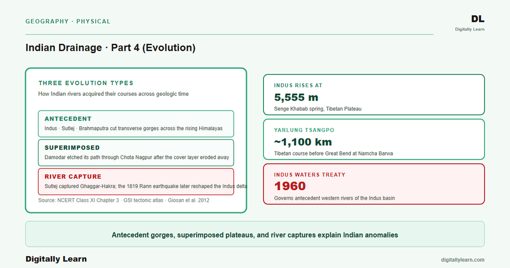
Geomorphologists distinguish three evolutionary classes for Indian rivers. The first uses a geometric vocabulary of consequent, subsequent, obsequent, and resequent streams set by original slope or structural strike. The second is antecedent drainage, where the river predates the uplift it crosses. The third is superimposed drainage, where the river began on a younger cover since stripped. A fourth process, river capture, operates whenever one network diverts a neighbour.
- Consequent, subsequent, obsequent, and resequent streams: The basic geometric vocabulary, where streams flow in directions related to original slope, structural strike, against original dip, or in the original dip direction after stripping.
- Antecedent drainage: The river predates the uplift it crosses and has incised vertically as the land rose around it (Indus, Sutlej, Brahmaputra).
- Superimposed drainage: The river was initiated on a cover of younger rock since stripped by erosion, and has continued on the exhumed older basement while preserving the original pattern (Damodar, Subarnarekha, Chambal).
| Class | Defining feature | Indian example | Diagnostic evidence |
|---|---|---|---|
| Antecedent | River older than the uplift it crosses | Indus, Sutlej, Brahmaputra | Transverse gorges deeper than ridge crest; pre-Pliocene basin sediments |
| Superimposed | River initiated on younger cover since stripped | Damodar, Subarnarekha, Chambal | Pattern preserved on exhumed Precambrian basement; coal-belt borehole stratigraphy |
| Consequent-subsequent geometry | Streams aligned with original or structural slope | Peninsular east-flowing rivers on Eastern Ghats slope | Course follows present regional slope; no transverse anomaly |
Antecedent Drainage: Rivers Older Than the Mountains They Cross
Three Distinguishing Features of Antecedent Rivers in India
Definition: An antecedent river is one whose course was set before the present uplift began. As the land rose, the river held its course by cutting downward at a rate matching the uplift. The result is a river that crosses a major range through a deep transverse gorge rather than going around it. Antecedence is inferred from present gorge geometry, the comparative age of basin sediments above and below the range, and dating of faunas trapped in lake deposits.
The three classic Indian antecedent rivers all rise on the Tibetan plateau north of the present Himalayan crestline. The Indus rises at the Senge Khabab spring near Mount Kailash, then turns sharply southwest through the Nanga Parbat syntaxis. The Sutlej rises near Lake Manasarovar and turns south through the Shipki La gap. The Brahmaputra runs east as the Yarlung Tsangpo before looping south at Namcha Barwa.
- Indus: Rises at the Senge Khabab spring near Mount Kailash at over five thousand metres elevation; turns sharply southwest at Nanga Parbat to cut its transverse gorge.
- Sutlej: Rises in the Rakas Tal area near Lake Manasarovar; flows west across Tibet and turns south through the Shipki La gap into Himachal Pradesh.
- Brahmaputra: Rises near Mount Kailash on the Tibetan plateau at over five thousand metres elevation; flows east as the Yarlung Tsangpo for over a thousand kilometres and loops south at the Namcha Barwa Great Bend.
Both the Indus and the Brahmaputra are diagnosed as antecedent: each existed before the Himalaya and entrenched itself while the range rose. Their Tibetan headwaters mark the antiquity of the drainage, not its recency. Their behaviour at the Himalayan front, turning sharply south through narrow gorges rather than continuing east or west, is the surface signature of the antecedent process working over geological time.
How the Himalayan Gorges Record the Antecedent Process
Near Nanga Parbat the Indus passes gorges four thousand five hundred to five thousand two hundred metres deep. Around Namcha Barwa, the Yarlung Tsangpo canyon walls rise five thousand metres and more on each side. Both figures exceed any Alpine peak. They are the strongest morphological evidence that the river predates the mountain: water cutting from above could not reach such depths without continuing tectonic supply of relief, so the river was there before the relief existed.
The Himalayan front still rises at about five millimetres per year, with peak rates near seven millimetres per year at the Nanga Parbat and Namcha Barwa syntaxes. The antecedent rivers keep incising at matching rates to hold their courses. The rate is small in human terms but vast in geological time: one million years at five millimetres yields five kilometres of incision, close to the present gorge depths. Antecedent drainage is a continuing equilibrium, not a one-time event.
Superimposed Drainage: Patterns Preserved on Exhumed Basement
How Superimposed Rivers Acquire Their Anomalous Courses
Definition: A superimposed river is one whose pattern was first set on a cover of younger sedimentary rock later stripped by erosion. After the cover was removed, the river kept flowing on the underlying older basement, holding a pattern that bears no relation to the present surface structure. The drainage develops on the younger rocks; as denudation removes them, the river continues over what is in fact a much older geological formation.
Three Indian rivers display clear superimposed character. The Damodar cuts east across crystalline Chotanagpur basement in a course unrelated to the plateau's structural grain. The Subarnarekha parallels it across the same basement. The Chambal crosses Vindhyan and Aravalli grain in a course explicable only by superimposition on a now-stripped cover. All three began on the Gondwana-Tertiary cover that once draped the Peninsular basement and have continued on the exhumed Precambrian floor.
- Damodar: Cuts east across crystalline Chotanagpur basement in Jharkhand and West Bengal in a course unrelated to the structural grain of the plateau.
- Subarnarekha: Parallels the Damodar on a similar east-flowing course across the same Precambrian basement.
- Chambal: Cuts across Vindhyan and Aravalli structural grain in a course explicable only by superimposition on a now-stripped Gondwana sedimentary cover.
The Damodar Anomaly and the Borehole Evidence
The Damodar coal belt supplies the borehole record that fixes the superimposed diagnosis. Drilling through the valley sediments shows Lower Gondwana coal-bearing rocks resting on the Precambrian basement, with the present river reworking the upper column. The surface course follows neither the Precambrian grain nor the modern slope. It is explained only by a river set on a now-stripped cover whose slope ran east, holding that east-flowing course as the cover thinned.
Similar logic applies to the Narmada and the Tapi, although both also carry a rift-valley structural component. As a group, the Peninsular rivers express a much older drainage system than the Himalayan ones. The Aravalli belt, the oldest fold mountains in India, is widely cited at about three hundred and seventy million years for the late-Palaeozoic folding, while the deeper Aravalli Supergroup basement reaches into the Paleoproterozoic.
The Peninsular drainage that flows around and across this old range has had time to mature in ways the Himalayan rivers cannot match. Superimposition is therefore most visible on the Peninsular plateau: the long stability of the craton has allowed repeated cover-stripping cycles to shape the present landscape, leaving rivers whose courses record covers that no longer exist.
River Capture and Course Shifts: When One Network Steals From Another
What River Capture Is and How It Operates
Definition: River capture, also called stream piracy, is the process in which a stream is diverted from its own bed into the bed of a neighbour. The captured river loses part or all of its catchment; the capturing river gains discharge, sediment load, and basin area. Capture rearranges the drainage network, sometimes within years during a single avulsion and sometimes over thousands of years through gradual headward erosion.
Stream capture operates through four distinct mechanisms identified in the geomorphological literature. Headward erosion extends one stream valley upward into the divide between basins until it breaches the divide. Natural damming by a landslide or ice sheet forces water into a different basin. Lateral erosion through a meander intercepts the flow of an adjacent stream. Tectonic capture by ground movement tips a stream out of its former course. Indian examples of all four mechanisms exist in the geological record.
- Headward erosion: One stream valley extends upward into the divide between basins, eventually breaching the divide and tapping the neighbouring catchment.
- Natural damming: A landslide or ice sheet blocks the original channel and forces water into a different basin.
- Lateral erosion: A meander cuts through the higher ground dividing adjacent streams and intercepts the flow.
- Tectonic capture: Ground movement changes the slope of the land and tips a stream out of its former course into a neighbouring one.
The Sutlej-Saraswati Capture and the Lost River of the Vedic Texts
Observable outcome (a): The most studied Indian capture episode is the diversion of the Sutlej from the Ghaggar-Hakra system to its present Indus course. Luminescence dating of palaeochannel sands indicates that the Sutlej once flowed down the Ghaggar-Hakra. Its abandonment of that westward course began about fifteen thousand years ago and was complete by about eight thousand years ago, leaving the Ghaggar-Hakra a monsoon-fed seasonal system terminating in the Thar Desert.
The capture rerouted the Sutlej northwest into the Beas-Indus drainage. Sediment and zircon studies show that once the Sutlej departed, the residual Ghaggar-Hakra was monsoon-fed rather than glacier-fed. The story matches the Vedic memory of a once-great Saraswati flowing from mountains to sea; many researchers now identify the Saraswati of the Rig Veda with the Sutlej-fed Ghaggar-Hakra before its capture. The diversion here operated through tectonic readjustment of the Himalayan foreland.
The Kosi Migration: Sorrow of Bihar in 250 Years
Observable outcome (b): The Kosi flows from Nepal into north Bihar carrying one of the heaviest sediment loads of any large Asian river. Its alluvial fan shows lateral shifting exceeding one hundred and twenty kilometres over two hundred and fifty years through at least twelve major channels. The mechanism is sediment-driven: each monsoon raises the bed above the floodplain until the river breaches its levees onto a lower path.
The river that flowed near Purnea in the eighteenth century now runs far to the west. On eighteen August 2008 the Kosi made its most dramatic recent shift, reoccupying a channel abandoned for over a century; within days most of its water ran through the new course. The avulsion displaced roughly three million people. Annual Kosi floods affect about twenty-one thousand square kilometres of farmland, which is why the river is called the Sorrow of Bihar.
The Indus After the 1819 Rann of Kutch Earthquake
Observable outcome (c): The 1819 Rann of Kutch earthquake is one of the largest historical earthquakes recorded on the Indian subcontinent. It produced the Allah Bund uplift, a ridge that dammed the Nara, a distributary of the Indus that fed the Great Rann of Kachchh. With the eastern channel blocked, Indus flow stayed to the west, and the river has not returned to its pre-1819 distribution in the two centuries since.
During exceptional monsoon flooding in 2011, Indus waters were reported to have re-entered Indian territory through the Great Rann of Kachchh. The episode shows that tectonically driven shifts are not closed chapters of the geological past but live processes still able to redirect one of the subcontinent's largest rivers. Course-shift events of this kind are the bridge between drainage evolution as a geological topic and drainage management as a contemporary policy problem.
Contemporary Evolution: How Climate Change Is Rewriting the Story
Why the Next Chapter of Indian Drainage Evolution Is Already Being Written
Contemporary linkages: Drainage evolution is often told as a story of the geological past, yet the antecedent Himalayan rivers are still incising, the Peninsular drainage is still shedding sediment, and the channel shifts of the Kosi and the Brahmaputra keep rearranging the lower courses each decade. The single most important driver of the next phase is climate change acting on the Tibetan plateau and the Himalayan glaciers that feed the antecedent rivers.
The International Centre for Integrated Mountain Development reports continued thinning and recession of Himalayan glaciers across all major basins. The Indian Himalayan glaciers that feed the Indus, the Sutlej, the Ganga, and the Brahmaputra are losing mass faster than at any time in the instrumental record. The downstream consequences operate on three distinct timescales: decadal, multi-decadal to centennial, and century-plus.
- Decadal: Increased meltwater run-off temporarily raises flow, masking the underlying problem.
- Multi-decadal to centennial: Declining ice mass reduces the buffer that smooths winter-summer flow contrasts, increasing both flood peaks and dry-season scarcity.
- Century-plus: Terminal loss of small and mid-sized glaciers shifts the antecedent rivers from glacier-and-monsoon-fed to monsoon-only regimes, with cascading effects on agriculture, hydropower, and inter-state water sharing.
The same evolutionary processes that produced the present geometry are now operating on policy-relevant timescales. River-linking proposals, inter-state water-sharing arrangements, flood management infrastructure, and hydropower siting decisions all rest on assumptions about flow regimes that the climate signal is steadily undermining. Drainage evolution has therefore moved from being a chapter of geomorphological history to being a continuing input into water-resource planning for the Indian republic. The geological perspective is the only one that captures the full timescale of the problem.
Prelims MCQ practice
Each question below tests one specific concept on the topic. Click to reveal the answer and a full option-wise explanation.
Q1. Consider the following statements about antecedent rivers in India:
- The Indus rises at the Senge Khabab spring near Mount Kailash on the Tibetan plateau at over five thousand metres elevation.
- The Brahmaputra rises near Mount Kailash on the Tibetan plateau and flows east as the Yarlung Tsangpo for over a thousand kilometres before turning south at the Great Bend.
- The Sutlej originates south of the main Himalayan crestline and is therefore not an antecedent river.
Which of the statements given above are correct?
- 1 only
- 1 and 2 only
- 2 and 3 only
- 1, 2 and 3
Show answer and explanation
Answer: 1 and 2 only
Explanation.
Statement 1 is correct: the Indus rises at the Senge Khabab spring near Mount Kailash at over five thousand metres. Statement 2 is correct: the Brahmaputra rises near Mount Kailash on the Tibetan plateau and flows east as the Yarlung Tsangpo for over a thousand kilometres before the Great Bend at Namcha Barwa. Statement 3 is incorrect: the Sutlej rises at Rakas Tal near Lake Manasarovar in Tibet, north of the main crest, and is therefore antecedent like the Indus and the Brahmaputra.
Q2. Consider the following statements about superimposed drainage in India:
- The Damodar river flows east across crystalline Chotanagpur basement in a course that bears no relation to the structural grain of the present surface.
- Superimposed rivers were initiated on a cover of younger rock that has since been removed by erosion.
- The Subarnarekha and the Chambal are also classified as superimposed rivers.
Which of the statements given above are correct?
- 1 only
- 1 and 2 only
- 2 and 3 only
- 1, 2 and 3
Show answer and explanation
Answer: 1, 2 and 3
Explanation.
All three statements are correct. The Damodar cuts east across Chotanagpur basement in a course unrelated to the present structural grain (Statement 1). Superimposed rivers were initiated on a younger sedimentary cover that has since been stripped by denudation (Statement 2). The Subarnarekha and the Chambal show the same superimposed character on the exhumed Precambrian basement (Statement 3).
Q3. Consider the following statements about the Kosi river:
- The Kosi has shifted its main channel more than one hundred kilometres westward over the past two hundred and fifty years.
- The Kosi avulsion of August 2008 reactivated an old channel that had been abandoned for over a century.
- The annual floods of the Kosi affect about twenty-one thousand square kilometres of agricultural land in Bihar.
Which of the statements given above are correct?
- 1 and 2 only
- 2 and 3 only
- 1 and 3 only
- 1, 2 and 3
Show answer and explanation
Answer: 1, 2 and 3
Explanation.
All three statements are correct. Lateral channel shifting has exceeded one hundred and twenty kilometres in the past two hundred and fifty years (Statement 1). The 2008 avulsion reoccupied an old channel abandoned for over a century, with most of the river's water shifting to the new course within days (Statement 2). About twenty-one thousand square kilometres of agricultural land is affected annually, which is why the Kosi is called the Sorrow of Bihar (Statement 3).
Q4. Consider the following statements about the Sutlej-Saraswati capture episode:
- Geological evidence suggests the Sutlej once flowed into the Ghaggar-Hakra system before being captured into the Indus drainage.
- The Sutlej abandonment of its westward course was complete by approximately eight thousand years ago.
- The residual Ghaggar-Hakra system after the capture was glacier-fed rather than monsoon-fed.
Which of the statements given above are correct?
- 1 only
- 1 and 2 only
- 2 and 3 only
- 1, 2 and 3
Show answer and explanation
Answer: 1 and 2 only
Explanation.
Statement 1 is correct: the Sutlej is documented to have once flowed into the Ghaggar-Hakra before tectonic readjustment captured it into the Beas-Indus drainage. Statement 2 is correct: Singh and colleagues 2017 dated the abandonment as complete by about eight thousand years ago using optically stimulated luminescence. Statement 3 is incorrect: Giosan and colleagues 2012 demonstrated that the residual Ghaggar-Hakra was monsoon-fed rather than glacier-fed once the Sutlej departed.
Q5. Consider the following mechanisms of river capture:
- Headward erosion extends one stream valley upward into the divide between basins.
- Tectonic uplift can change the slope of the land and tip a stream out of its former course.
- Lateral erosion through a meander can intercept the flow of an adjacent stream.
Which of the mechanisms given above are recognised in the geomorphological literature on stream capture?
- 1 only
- 1 and 2 only
- 2 and 3 only
- 1, 2 and 3
Show answer and explanation
Answer: 1, 2 and 3
Explanation.
All three are recognised mechanisms of stream capture, along with a fourth mechanism of natural damming by landslide or ice sheet.
Sources
- India Physical Environment, Class 11, Chapter 3: Drainage System
- Indus River
- Brahmaputra River
- Kosi River
- Ghaggar-Hakra River
- Stream capture
- Tectonic Atlas of India and Coal-field Memoirs
- Flood plain maps and basin reports
- National River Linking Project documents
- National Mission for Sustaining the Himalayan Ecosystem
- Annual climate summary and Indian rainfall reports
- Himalayan glacier monitoring layers
Disclaimer
This article synthesises the canonical geomorphological treatment of Indian drainage evolution as presented in NCERT and the peer-reviewed literature. The numerical claims on river sources, gorge depths, glacier ages, and channel migrations follow the cited authoritative geological and hydrological agencies. Readers seeking primary citations for any specific number should consult the Sources block.


