


Overview
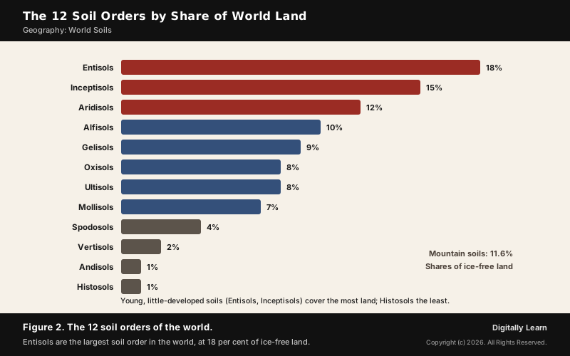
Soil orders are the broadest groups of USDA soil taxonomy, which sorts the world's soils into 12 orders by properties that reflect how they formed, from frozen Gelisols to weathered tropical Oxisols. Their global distribution follows climate and vegetation: each belt of climate has its typical soil, broken by mountains, rivers and wetlands.
World Soil Types: Why Soils Follow Climate
Global Distribution of Soils: The Zonal Idea
The global distribution of soils follows climate, because soil forms from weathered rock under the work of water, heat and living things. Soil adjusts to the climate, landform and vegetation around it, and changes internally when these change. That is why each great belt of climate carries its own typical soil.
The idea began on the steppes. In 1883 Vasily Dokuchaev studied the steppe soils of the Poltava region, noticed that peasants named soils by their colour, and published Russian Chernozem, the black earth of the grasslands. His work turned soil into a product of climate, vegetation, relief, parent material and time, and the factors are explained in genesis of soil.
- Wet tropics: Bacteria act fast and dead vegetation is quickly oxidised, so humus stays low and profiles are deep.
- Cold climates: Bacteria grow slowly, humus accumulates, and peat develops in sub-arctic and tundra climates.
- Dry climates: Evaporation exceeds precipitation, and salts left behind form hardpans.
| Climate and vegetation | Typical zonal soil (order) |
|---|---|
| Tundra, permafrost | Tundra soils (Gelisols) |
| Cool coniferous forest | Podzols (Spodosols) |
| Mid-latitude grassland | Chernozem (Mollisols) |
| Hot desert | Desert soils (Aridisols) |
| Humid tropical forest | Ferralsols, laterites (Oxisols) |
Zonal, Intrazonal and Azonal Soils: The Genetic Classification
The older genetic classification of 1938 sorted soils into three groups by the factor that dominates their formation: climate, a local factor, or too little time.
| Group | What controls it |
|---|---|
| Zonal soils | Climate and vegetation of a belt; mature profiles |
| Intrazonal soils | A local factor of relief or parent material overrides climate |
| Azonal soils | Too young to develop a profile; mountain slopes, new alluvium |
- Calcimorphic (intrazonal): Develop on limestone; rendzinas are thin, terra rossa soils deep red.
- Hydromorphic (intrazonal): Form in wetlands; gley soils turn grey or blue when waterlogging reduces their iron, and peat forms where vegetation cannot break down.
- Halomorphic (intrazonal): Form through salinisation.
- Azonal: On Himalayan slopes weathered material keeps sliding down, and on flood plains new alluvium arrives every year, so soils stay immature even where farmland is fertile.
The 12 Soil Orders of USDA Soil Taxonomy
What Is a Soil Order? The USDA Soil Taxonomy
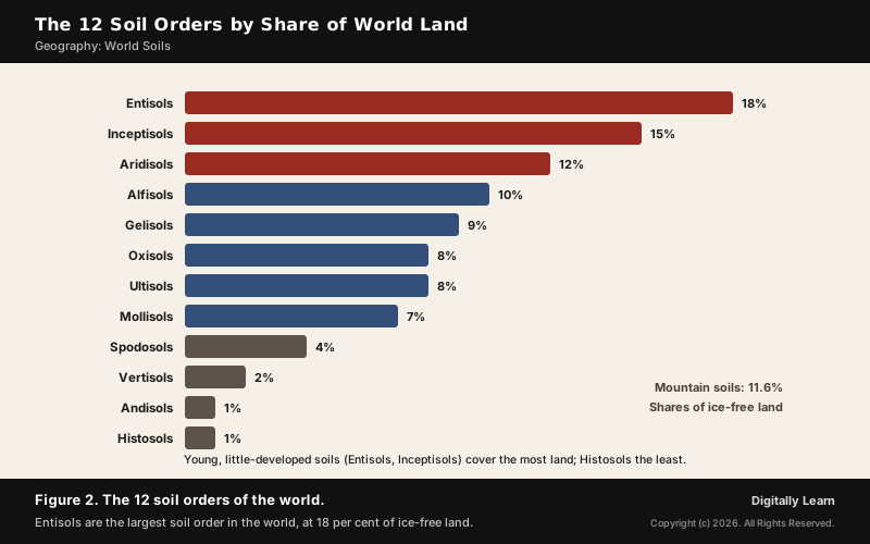
A soil order is the top level of USDA soil taxonomy, which sorts the soil types of the world into 12 orders of soil within six levels: order, suborder, great group, subgroup, family and series. It uses measurable properties such as depth, moisture, temperature, texture, structure, organic matter and salt content, and every order name ends in -sol.
| Soil order | Meaning and share of ice-free land |
|---|---|
| Entisols | Recent soils, no developed horizons; 18% |
| Inceptisols | Young soils, some subsurface horizons; 15% |
| Aridisols | Dry desert soils; about 12% |
| Alfisols | Clay-rich forest soils with aluminium and iron; 10% |
| Gelisols | Permafrost soils; 9% |
| Oxisols | Deeply weathered tropical soils; 8% |
| Ultisols | Acid, leached humid soils; 8% |
| Mollisols | Dark, soft grassland soils; 7% |
| Spodosols | Acid soils of cool forests; 4% |
| Vertisols | Swelling, cracking clays; 2% |
| Andisols | Volcanic ash soils; 1% |
| Histosols | Organic peat soils; 1% |
Soil Orders of Cold and Wet Lands: Gelisols, Histosols and Spodosols
Cold slows chemical activity, which stops altogether in freezing conditions, so soils of the frozen north are largely mechanically broken material shaped by ice and water. Three orders dominate the far north.
- Gelisols: Soils with permafrost within two metres of the surface, churned by freezing and thawing; found chiefly in Siberia, Alaska and Canada. Organic matter gathers in the top layer, so most are black or dark brown, yet nutrients such as calcium and potassium leach easily above the frozen layer, so they are not very fertile.
- Histosols: Organic soils, formerly called bog soils, formed where waterlogging stops plant remains from decaying; most lie in Canada, Scandinavia, the West Siberian Plain, Sumatra, Borneo and New Guinea.
- Spodosols (podzols): Acid soils of coniferous and boreal forests, where acids leach iron and aluminium down from an ash-grey upper layer, usually on quartz-rich sands.
The name podzol is Russian for under-ash soil: peasants ploughing virgin ground turned up a pale, ash-like leached layer, the E horizon, low in iron, aluminium and humus. Histosols and Gelisols together store large quantities of organic carbon, which is why the cold north matters so much for the climate.
Soil Orders of Grasslands and Deserts: Mollisols, Aridisols and Vertisols
The drier interiors of continents carry soils that keep their nutrients because little water washes through them. Grassland roots add organic matter; desert heat adds salts.
- Mollisols: Deep, dark, fertile soils with a thick organic-rich top layer 60 to 80 cm deep, the mollic epipedon, built by grass roots; typical of the North American Great Plains and Central Asia.
- Aridisols: Dry desert soils with fewer than 90 consecutive moist days in the growing season, little organic matter and layers of caliche or duripan; they dominate the deserts and dry shrublands that cover about one-third of the Earth’s land, and India’s arid soils belong here.
- Vertisols: Clay-rich soils that swell when wet and crack deeply when dry; major areas include eastern Australia, the Deccan Plateau of India and parts of Sudan, Ethiopia and Chad.
India's black soils of the Deccan are Vertisols, and its desert soils are Aridisols, explained in arid soil.
Soil Orders of Forests and the Tropics: Alfisols, Ultisols and Oxisols
Where rain and warmth last long enough, weathering runs deep and leaching strips out bases. Three orders show the sequence from moderately to extremely weathered.
- Alfisols: Clay-enriched forest soils with enough moisture and warmth for at least three months of plant growth; found in the Ohio basin, western Europe, European Russia and the drier parts of Peninsular India.
- Ultisols: Acid, highly weathered soils of humid temperate and tropical regions, poor in calcium, magnesium and potassium; the red clays of the southern United States.
- Oxisols: The most weathered soils, rich in iron and aluminium oxides but low in silica, in tropical rain forest within 25 degrees of the equator, almost wholly in South America and Africa.
Tropical rainforest soils surprise students: the richest forests stand on some of the poorest soils. Rain passing through the litter on the forest floor is acidified and leaches minerals from the upper layers, and in the heat bacteria oxidise dead vegetation so fast that little humus is left. The forest keeps its nutrients in living plants, so clearing it leaves bare, poor ground.
In order of increasing development, the orders run Entisols, Inceptisols, Aridisols, Mollisols, Alfisols, Spodosols, Ultisols and Oxisols; Histosols and Vertisols can appear at any stage. India's laterite soils form the same way, by intense leaching under tropical rain; see laterite soil.
Young and Volcanic Soil Orders: Entisols, Inceptisols and Andisols
The largest orders are the least developed. Entisols and Inceptisols together cover a third of the world's ice-free land, because so much land is young, steep, sandy or freshly deposited.
- Entisols: Recently formed soils without developed horizons, common on river and beach sediments and volcanic ash; some are only an A horizon on bedrock.
- Inceptisols: Young soils with some subsurface horizon but little eluviation and illuviation; common in rocky or mountainous areas and on river, coastal and marine sediments, but not in deserts or permafrost.
- Andisols: Young volcanic ash soils, usually very fertile, about 1 per cent of ice-free land, mostly around the Pacific Ring of Fire in Chile, Ecuador, Japan, Java and New Zealand; wet rice on Java’s Andisols supports some of the densest populations in the world.
World Soil Types Map: Soil Zones Belt by Belt
Tundra Soils and Permafrost: Fragile but Economically Important
Tundra soils sit on permafrost. In the Arctic tundra the ground is frozen from 25 to 90 cm down, which stops trees from growing; in summer only the top layer thaws, and because water cannot sink through the frozen ground it forms marshes, lakes and bogs.
- A carbon store: Tundra soils hold large amounts of biomass stored in the permafrost, making them a carbon sink; warming thaws them and releases greenhouse gases, which feeds further warming.
- Fragile ground: Thawing permafrost could change which species survive within decades, and buildings subside as frozen ground thaws beneath them.
- Economic value: The Arctic tundra is rich in petroleum, natural gas and uranium; the Yamalo-Nenets region produces 90 per cent of Russia’s natural gas, and nomadic reindeer herders such as the Nenets live on the tundra.
Chernozem and Grassland Soils: The World's Breadbaskets
Some of the richest farm soils lie under the mid-latitude grasslands. Chernozem, the black earth, carries a high share of humus, 4 to 16 per cent, stores moisture well and gives high yields; it is found across the steppes of Russia and Ukraine, the Great Plains of the United States and Canada, and the Pampas.
- Why so fertile: Grass roots add organic matter year after year, building the thick dark top layer; the steppes receive 250 to 500 mm of rain a year, more than twice as much as true deserts.
- Why still fragile: Long cropping depletes the humus, so even chernozems need fertiliser.
- In classification: Chernozems are Mollisols in USDA soil taxonomy and a Reference Soil Group of their own in the World Reference Base.
The grassland soils change in a sequence as the climate dries. In the Northern Hemisphere the chestnut-coloured Kastanozems border the chernozem belt on the cooler, less arid north, and give way to Calcisols and Gypsisols, and near salt basins to Solonchaks and Solonetz, in the warmer and drier south. Read from the wet edge of the steppe to the desert, the soils gain lime, then gypsum, then salt.
World Soil Classification and the Soil Orders of India
FAO World Reference Base: 32 Reference Soil Groups
The World Reference Base for Soil Resources is the international system for naming soils and making the legends of soil maps. Its current fourth edition, of 2022, is edited by a working group of the International Union of Soil Sciences, and its first level has 32 Reference Soil Groups.
| USDA soil order | Main WRB groups |
|---|---|
| Gelisols | Cryosols |
| Spodosols | Podzols |
| Oxisols | Ferralsols |
| Aridisols | Calcisols, Gypsisols, Durisols, Solonchaks |
| Mollisols | Chernozems and other grassland groups |
The two systems overlap but do not match one to one; USDA uses measured properties to define orders, while the WRB names groups that suit a world soil map. The FAO's own lecture notes on the major soils of the world arrange the groups by what conditions them, which reads like a map of global soil distribution:
| Conditioned by | Reference Soil Groups |
|---|---|
| Permafrost | Cryosols |
| Wet (sub)tropical climate | Ferralsols, Nitisols, Acrisols, Lixisols, Alisols, Plinthosols |
| (Semi-)arid climate | Solonchaks, Solonetz, Gypsisols, Durisols, Calcisols |
| Steppic climate | Chernozems, Kastanozems, Phaeozems |
| (Sub)humid temperate climate | Podzols, Planosols, Albeluvisols, Luvisols, Umbrisols |
| Parent material | Andosols (volcanic), Arenosols (sands), Vertisols (expanding clays) |
| Topography | Fluvisols, Gleysols (lowlands); Leptosols, Regosols (mountains) |
Soil Orders in India: Inceptisols to Mollisols
India classifies its soils by the same USDA taxonomy. To study its soils and make them comparable at the international level, the Indian Council of Agricultural Research classified Indian soils into USDA orders, working through the National Bureau of Soil Survey and Land Use Planning.
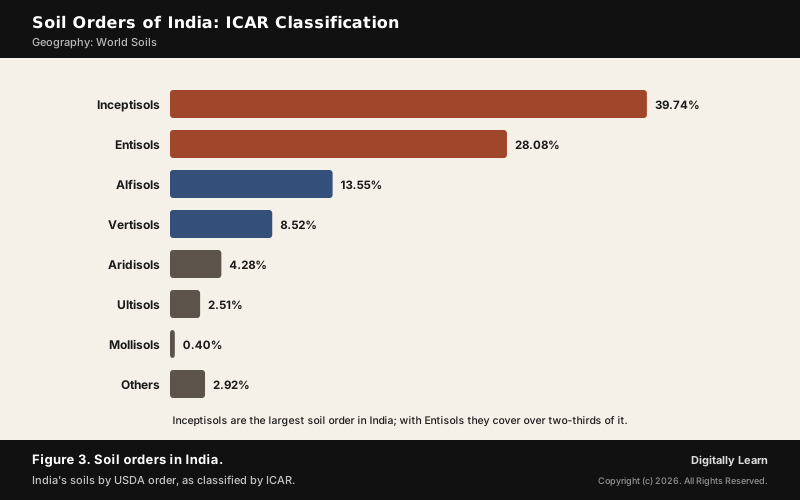
- Largest: Inceptisols, 39.74 per cent, and Entisols, 28.08 per cent, together over two-thirds of India.
- Next: Alfisols, 13.55 per cent, the drier Peninsula’s forest soils, and Vertisols, 8.52 per cent, the black soils of the Deccan.
- Smaller: Aridisols 4.28, Ultisols 2.51 and Mollisols 0.40 per cent.
Alongside the USDA orders, India's soils are also grouped by genesis, colour and location into alluvial, black, red and yellow, laterite and other types; that scheme is covered in the article on how India's soils are formed and classified.
Previous Year UPSC-CSE Questions
Previous Year UPSC-CSE Questions By the end you will be able to draft model answers for the following UPSC questions. Each question carries a collapsible framework showing how to approach it in the exam.
- UPSC Mains 2026 GS-I"Tundra regions are ecologically fragile but economically important." Examine this statement critically.
How to structure the answer in the exam
Introduction: Define tundra by its permafrost: ground frozen from 25 to 90 cm down, only the top layer thawing in summer.
Body (sub-themes to develop):
- Fragile: slow soil formation, waterlogged summer surface, Gelisols easily leached.
- Carbon: permafrost stores biomass; thaw releases greenhouse gases and feeds warming.
- Infrastructure: buildings subside as frozen ground thaws.
- Economy: petroleum, natural gas, uranium; Yamalo-Nenets gives 90 per cent of Russia's gas; reindeer herding.
Conclusion: Conclude that the same permafrost that holds the resources makes their extraction risky, so development must be slow and careful.
Sources
- NCERT: India Physical Environment (Class XI), Soils
- NCERT: Fundamentals of Physical Geography (Class XI), Geomorphic Processes
- FAO Soils Portal: World Reference Base for Soil Resources
- FAO: Lecture Notes on the Major Soils of the World
- USGS: Soils and paleosols (Muhs)
- United Nations: World Soil Day, 5 December
- Wikipedia: USDA soil taxonomy
- Wikipedia: World Reference Base for Soil Resources
- Wikipedia: Zonal soil
- Wikipedia: Gelisol
- Wikipedia: Histosol
- Wikipedia: Podzol
- Wikipedia: Mollisol
- Wikipedia: Chernozem
- Wikipedia: Vertisol
- Wikipedia: Oxisol
- Wikipedia: Alfisol
- Wikipedia: Andisol
- Wikipedia: Inceptisol
- Wikipedia: Tundra
- UPSC: Civil Services Examination question papers
Editorial Disclaimer
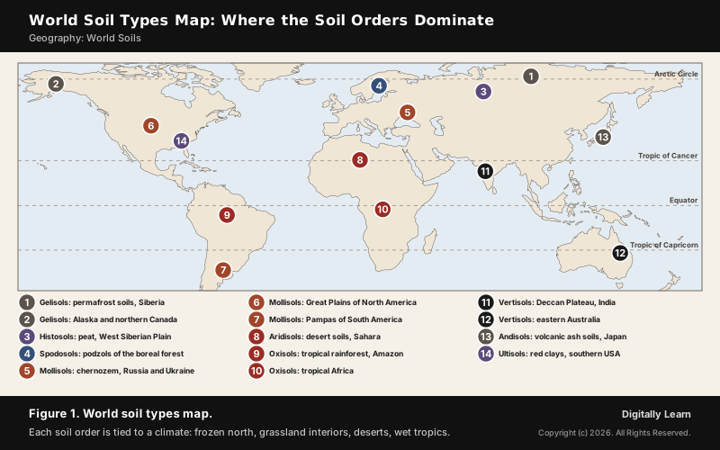
This article draws on the NCERT geography textbooks, the FAO, the US Geological Survey, the United Nations and the other sources listed on this page. Map markers show where an order dominates, not its exact extent.


