
Overview
India's Eight Climatic Regions
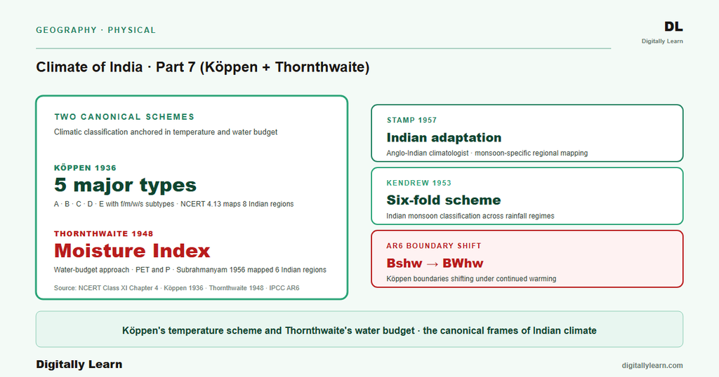
How three classification schemes reduce India's monsoon climate to named, plannable regions.
Previous Year UPSC-CSE Questions By the end you will be able to draft model answers for the following UPSC questions. Each question carries a collapsible framework showing how to approach it in the exam.
- UPSC Prelims 1995The graph given below shows the mean average monthly temperatures (in °C) and mean monthly rainfall (in cms) of a place: This graph is indicative of which one of the climatic zones of the world?
How to approach this Prelims question
Approach: The graph shows seasonally distinct rainfall (wet-and-dry pattern) with consistently warm temperatures throughout the year – this is the signature of wet-and-dry tropical climate (Köppen Aw, tropical savannah). Rainy tropical (Af) would show uniformly high rainfall year-round. Semi-arid tropical (BSh) would show low rainfall throughout. Temperate marine (Cfb) would show year-round moderate temperatures with no extreme seasonal contrast.
Trap to watch: Look for the seasonal contrast in rainfall combined with persistent warmth; do not confuse with rainy tropical (Af) which lacks a dry season.
Key facts to recall:
- Aw tropical savannah: distinct wet-dry seasons, mean monthly temperature consistently above 18C
- Af rainy tropical: uniform high rainfall, no dry season
- BSh semi-arid tropical: rainfall well below evaporation; consistent aridity
Answer signal: Correct answer is (a) (Wet and dry tropical).
Climatic classification reduces a country's lived climate to a small set of named regions defined by temperature and rainfall thresholds. The Köppen 1936 scheme identifies five major types (A tropical, B dry, C warm temperate, D cool temperate, E ice) modified by lower-case letters (f, m, w, s, h, c, g) and applies to India as eight regional sub-types. The Thornthwaite 1948 scheme replaces temperature thresholds with a Moisture Index built on potential evapotranspiration and precipitation. Indian regionalization by Stamp 1957, Kendrew 1953, Trewartha 1968, and Subrahmanyam 1956 adapts these frameworks to monsoon-specific conditions.
Background and Historical Context
Climatic classification is the operational language of regional planning in India. The Indian Council of Agricultural Research aligns its agro-climatic zoning to Köppen regions; the Forest Survey of India aligns Champion-Seth forest types to temperature-and-rainfall thresholds that mirror Köppen logic; the NDMA hazard atlas maps drought-prone districts to the BShw and BWhw regions and flood-prone districts to the Amw and Cwg regions. UPSC Prelims has tested climatograph identification and climatic-region pairings in 1995 and earlier, and Mains GS-I treats climatic classification as the foundational regional-geography framework.
What is the significance of the three-scheme approach? Each scheme captures a different organising principle. Köppen captures temperature-rainfall threshold combinations and produces named categorical regions. Thornthwaite captures the water-budget balance (PET versus precipitation) and produces a continuous index. Indian regionalization by Stamp, Kendrew, Trewartha, and Subrahmanyam adapts both world-applied schemes to the specific moisture-asymmetric character of the southwest monsoon and the temperature-asymmetric character of altitude across the Himalayan range.
The ICAR agro-climatic zoning and Champion-Seth forest classification both operate at the same scale as Köppen's eight Indian regions, which is why the schemes inter-translate cleanly. The IPCC AR6 South Asia chapter projects shifts in the boundary between BShw and BWhw under continued warming, with first-order implications for agro-climatic zoning under a 2 degrees Celsius warmer scenario.
Introduction: Why Climatic Classification Matters
Why classify a tropical-monsoon country
India's lived climate varies sharply across the subcontinent in temperature and rainfall, the two elements every classification scheme uses as primary variables. Reading the country as one uniform tropical-monsoon climate hides the operational differences between the 11,000-millimetre Western Ghats windward, the 200-millimetre Thar interior, the 0-degrees Celsius Himalayan high-altitude tract, and the 35-degrees Celsius Coromandel coast. Classification reduces this complexity into a small set of named regions that planners, farmers, hazard managers, and exam candidates can reason with.
Three classification schemes dominate Indian climatology: Wladimir Köppen's 1936 scheme applied by NCERT as the canonical reference; Charles Thornthwaite's 1948 Moisture Index approach centred on the water budget; and the Indian regionalization work of Stamp, Kendrew, Trewartha, and Subrahmanyam that adapts these world-applied schemes to monsoon-specific conditions.
Köppen System: Five Major Types and Letter Codes
The five major types defined by temperature thresholds
Köppen's 1936 scheme is the canonical reference in NCERT Class 11 IPE Chapter 4 and the framework UPSC tests directly when asking about Indian climatic regions. The scheme uses two empirical variables that observational records reliably capture: mean monthly temperature and monthly precipitation. UPSC Prelims has tested climatograph identification (1995 Q19) and climatic-region pairings, and Mains GS-I treats the Köppen framework as the foundation for regional climatic geography.
The five major Köppen types are: (A) Tropical with mean monthly temperature above 18 degrees Celsius; (B) Dry where precipitation is low relative to temperature (semi-arid S or arid W); (C) Warm temperate with the coldest month between 18 degrees Celsius and minus 3 degrees Celsius; (D) Cool temperate with the warmest above 10 degrees Celsius and coldest below minus 3 degrees Celsius; (E) Ice with the warmest month below 10 degrees Celsius.
- f: Sufficient precipitation throughout the year (no dry season).
- m: Rainforest despite a dry monsoon season (monsoonal variant of A).
- w: Dry season in winter (Indian Cwg, Aw apply).
- s: Dry season in summer (Mediterranean character; Indian As applies for Coromandel coast).
- h: Dry and hot (mean annual above 18 degrees Celsius).
- c: Cool summer (fewer than four months above 10 degrees Celsius).
- g: Gangetic plain (regional modifier specific to Indian application).
Köppen Applied to India: Eight Climatic Regions
The eight regions identified in NCERT
Why the eight-region scheme matters operationally. Applied to India, Köppen's framework identifies eight regional sub-types that together cover the entire country. The scheme captures the moisture-asymmetric character of the southwest monsoon (Amw on the windward Western Ghats versus BShw on the leeward Deccan interior) and the temperature-asymmetric character of altitude (Cwg in the warm Ganga plain versus E in the cold Himalayan high-altitude tract).
- (i) Amw – Monsoon with short dry season: West coast of India south of Goa (Malabar coast, Konkan).
- (ii) As – Monsoon with dry summer: Coromandel coast of Tamil Nadu; the only Indian Köppen region with the s code.
- (iii) Aw – Tropical savannah: Most of the peninsular plateaus south of the Tropic of Cancer (Karnataka, Telangana, AP interior).
- (iv) BShw – Semi-arid steppe: Northwestern Gujarat, parts of western Rajasthan, Punjab.
- (v) BWhw – Hot desert: Extreme western Rajasthan (Thar Desert; Jaisalmer-Barmer-Bikaner belt).
- (vi) Cwg – Monsoon with dry winter: Ganga plain, eastern Rajasthan, northern Madhya Pradesh, most of northeast India.
- (vii) Dfc – Cold humid winter with short summer: Arunachal Pradesh (the only Indian region in the D category).
- (viii) E – Polar type: Jammu and Kashmir, Himachal Pradesh, Uttarakhand high-altitude tracts.
Thornthwaite System: Moisture Index and the Water-Budget Approach
Moisture index and PET
Charles Thornthwaite's 1948 framework replaced Köppen's temperature thresholds with a water-budget approach. The scheme computes potential evapotranspiration (PET) for a location and compares it against precipitation receipts. The resulting Moisture Index ranges from above 100 (perhumid, water surplus dominant) through zero (humid-dry balance) to below minus 40 (arid, water deficit dominant). Indian application by C. S. Subrahmanyam in 1956 divided the country into six Thornthwaite regions ranging from perhumid Western Ghats windward to arid western Rajasthan.
Mechanism features of Thornthwaite versus Köppen run as the water-budget index advantage summarised below.
- (i) Water-budget basis: PET captures the energy-driven evaporation demand; precipitation captures the supply; the index integrates both rather than thresholding one.
- (ii) Continuous index: Regions emerge from index ranges, not from named categorical types.
- (iii) Crop-suitability friendliness: The water-budget framework maps directly to irrigation planning and agricultural moisture-deficit calendars.
Indian Regionalization Schemes: Stamp, Kendrew, Trewartha
Three monsoon-focused regional adaptations
Several schemes adapt the world-applied frameworks to Indian monsoon conditions. L. Dudley Stamp's 1957 work simplified India into climatic divisions on the 18.3 deg C monthly isotherm, emphasising the monsoon cycle and altitude controls. W. G. Kendrew's 1953 monsoon-centric scheme grouped India by south-west-monsoon arrival patterns.
G. T. Trewartha's 1968 update of Köppen replaced some lower-case letters with simpler categorical names while preserving the underlying thresholds. C. S. Subrahmanyam's 1956 Thornthwaite application remains the most-cited Indian regionalization in academic geography.
| Scheme | Year | Organising basis |
|---|---|---|
| L. Dudley Stamp | 1957 | Seven climatic divisions keyed to the monsoon cycle and altitude controls |
| W. G. Kendrew | 1953 | Grouping by southwest-monsoon arrival and rainfall pattern |
| G. T. Trewartha | 1968 | Simplified update of Köppen, categorical names over letter codes |
| C. S. Subrahmanyam | 1956 | Thornthwaite Moisture Index applied across six Indian regions |
Regional Case Studies: Three Indian Climatic Regions in Detail
Western Ghats windward, Thar Desert, Himalayan high-altitude
Three Indian regions illustrate the descriptive power of the schemes. The Western Ghats windward (Köppen Amw, Thornthwaite perhumid) tract records annual rainfall above 11,000 millimetres at Mawsynram and Cherrapunji, driven by orographic uplift of the southwest monsoon; it defines the Indian extreme of moisture surplus.
The Thar Desert (Köppen BWhw, Thornthwaite arid) of western Rajasthan receives under 200 millimetres a year under the descending limb of the subtropical high; the India Meteorological Department treats it as the country's only true hot-desert regime. The Himalayan high-altitude tract (Köppen E) across Jammu and Kashmir, Himachal Pradesh, and Uttarakhand has warmest-month temperatures below 10 degrees Celsius, the cryosphere that feeds the Indus, Ganga, and Brahmaputra systems.
Outcome surfaces from this regional classification show in policy and planning across three domains, summarised below.
- (a) Agricultural zoning: The Indian Council of Agricultural Research uses Köppen-based agro-climatic zones for crop-suitability advisories.
- (b) Hazard mapping: Drought-prone areas align with the BShw and BWhw regions; flood-prone areas align with Amw and Cwg.
- (c) Tourism and forestry: Forest-type classification (Champion-Seth 1968) maps to Köppen regions through the temperature-rainfall threshold logic, and tourism-region planning by the Ministry of Tourism follows the same regional logic.
Prelims MCQ practice
Each question below tests one specific concept on the topic. Click to reveal the answer and a full option-wise explanation.
Q1. Consider the following statements about the Köppen climate classification:
- The Köppen climate classification was developed by Wladimir Köppen, a German climatologist.
- It uses temperature and precipitation thresholds (annual and seasonal) to demarcate climate types and is among the most widely used climate classifications globally.
Which of the statements given above is/are correct?
- 1 only
- 2 only
- Both 1 and 2
- Neither 1 nor 2
Show answer and explanation
Answer: Both 1 and 2
Explanation.
Correct: c (Both 1 and 2). Both statements are correct. The Köppen climate classification was developed by Wladimir Köppen (German climatologist, with refinements by Rudolf Geiger). It uses temperature and precipitation thresholds (annual and seasonal) to demarcate climate types and is among the most widely used global climate classifications.
Q2. Consider the following statements about the Köppen Amw (tropical monsoon with dry winter) climate in India:
- Amw is confined to the Coromandel coast of Tamil Nadu and does not occur on India's west coast.
- It is characterised by heavy summer-monsoon rainfall, hot temperatures, and a short dry season.
Which of the statements given above is/are correct?
- 1 only
- 2 only
- Both 1 and 2
- Neither 1 nor 2
Show answer and explanation
Answer: 2 only
Explanation.
Correct: b (2 only). Statement 1 is wrong: Amw lies on the west coast south of Goa (Konkan, Malabar), not the Coromandel coast, which is the As region. Statement 2 is correct: Amw brings heavy southwest-monsoon rainfall, hot temperatures, and a short dry season.
Q3. Consider the following statements about the Köppen Aw (tropical savanna) climate in India:
- Aw covers much of peninsular India south of the Tropic of Cancer except the rain-shadow tracts.
- It is characterised by hot temperatures year-round with a dry winter and a wet summer (monsoon).
- Aw climates are typical of large parts of Maharashtra, Madhya Pradesh, Karnataka interior, Telangana, and Andhra Pradesh.
Which of the statements given above are correct?
- 1 and 2 only
- 2 and 3 only
- 1 and 3 only
- 1, 2 and 3
Show answer and explanation
Answer: 1, 2 and 3
Explanation.
Correct: d (1, 2 and 3). All three are correct. Köppen Aw (tropical savanna) covers much of peninsular India south of the Tropic of Cancer (excluding rain-shadow tracts which are BSh). Hot year-round with dry winter and wet summer monsoon. Typical of Maharashtra, MP, Karnataka interior, Telangana, AP.
Q4. Consider the following statements about the Köppen BSh (hot semi-arid) climate in India:
- BSh covers parts of central and northwestern peninsular India lying in the rain-shadow of the Western Ghats.
- It is characterised by moderate-to-low annual rainfall (typically 250-750 mm) and hot temperatures.
Which of the statements given above is/are correct?
- 1 only
- 2 only
- Both 1 and 2
- Neither 1 nor 2
Show answer and explanation
Answer: Both 1 and 2
Explanation.
Correct: c (Both 1 and 2). Both statements are correct. Köppen BSh (hot semi-arid steppe) covers parts of central and northwestern peninsular India in the Western-Ghats rain shadow. Moderate-to-low annual rainfall (around 250-750 mm) and hot temperatures.
Q5. Consider the following statements about the Köppen BWh (hot desert) climate in India:
- BWh covers most of western Rajasthan (Thar Desert) and parts of adjacent Pakistan (Sindh, Cholistan).
- It is characterised by very low annual rainfall (typically less than 250 mm), high diurnal temperature range, and extreme summer heat.
Which of the statements given above is/are correct?
- 1 only
- 2 only
- Both 1 and 2
- Neither 1 nor 2
Show answer and explanation
Answer: Both 1 and 2
Explanation.
Correct: c (Both 1 and 2). Both statements are correct. Köppen BWh (hot desert) covers most of western Rajasthan (Thar Desert) and adjacent Pakistan (Sindh, Cholistan). Very low annual rainfall (less than 250 mm), high diurnal temperature range, and extreme summer heat.
Q6. Consider the following statements about Köppen climate types in the Himalayan region of India:
- Himalayan climate varies sharply with altitude, from sub-tropical at the foothills (Cwa/Cwb) to tundra-like (ET/EF) at the highest elevations.
- Ladakh's cold-desert climate is classified as BWk (cold desert) in the Köppen scheme.
Which of the statements given above is/are correct?
- 1 only
- 2 only
- Both 1 and 2
- Neither 1 nor 2
Show answer and explanation
Answer: Both 1 and 2
Explanation.
Correct: c (Both 1 and 2). Both statements are correct. Himalayan climate varies sharply with altitude (sub-tropical Cwa/Cwb foothills through temperate to tundra-like ET/EF at the highest elevations). Ladakh's cold-desert climate is classified as BWk (cold desert; 'k' for cold) in the Köppen scheme, distinguishing it from the hot Thar Desert (BWh).
Sources
- NCERT Class 11 India Physical Environment, Chapter 4 (Climate); Table 4.1 and Figure 4.13
- Köppen, W. (1936) Das geographische System der Klimate
- Thornthwaite, C. W. (1948) An Approach toward a Rational Classification of Climate
- India Meteorological Department (IMD) regional climatology
- Wikipedia: Climate of India
- Wikipedia: Köppen climate classification
- Wikipedia: Tropical monsoon climate
- Wikipedia: Tropical savanna climate
Disclaimer
This article is study material for UPSC preparation, not a substitute for primary sources. Climatic-region boundaries and codes are generalised at the scale used by NCERT and standard climatology references. Verify specific figures against the authoritative sources listed below.


