
Overview
Previous Year UPSC-CSE Questions By the end you will be able to draft model answers for the following UPSC questions. Each question carries a collapsible framework showing how to approach it in the exam.
- Prelims 2022Gandikota canyon of South India was created by which one of the following rivers?
How to approach this Prelims question
Approach: Recall that the Gandikota canyon in the Kadapa district of Andhra Pradesh was carved by the Pennar river over geological time. The Pennar runs from Karnataka through Andhra Pradesh to the Bay of Bengal, cutting through the Erramala range of the Eastern Ghats at Gandikota.
Trap to watch: Tungabhadra is the most-cited Krishna tributary in southern Karnataka and is a common wrong choice. Manjira is a Godavari tributary. Cauvery cuts the Hogenakkal Falls and Sivasamudram Falls but not the Gandikota canyon.
Key facts to recall:
- Gandikota canyon: Kadapa district, Andhra Pradesh.
- Pennar river: rises in Karnataka, flows east through Andhra Pradesh.
- Cuts through the Erramala range at Gandikota.
- Often called the Grand Canyon of India.
Answer signal: Pennar (option c).
- Prelims 2004With reference to the drainage of Peninsular India, consider the following:
- Assertion (A): West-flowing rivers of Peninsular India have no deltas.
- Reason (R): These rivers do not carry any alluvial sediment.
In the context of the above two statements, which one of the following is correct?
How to approach this Prelims question
Approach: Assertion is TRUE: west-flowing Peninsular rivers (Narmada, Tapti, Western Ghat rivers) form estuaries rather than deltas. Reason is FALSE: these rivers DO carry alluvial sediment; the actual reasons for no-delta geometry are the narrow Arabian Sea coastal plain, the steep continental shelf, the strong tidal action, and the rift-confined sediment delivery for the Narmada and Tapti specifically (covered in Part 12 of this series).
Trap to watch: Treating the Reason as plausible because the rivers do have moderate sediment loads is the common error; the actual structural causes are the coastal-plain geometry and tidal action, not the absence of sediment.
Key facts to recall:
- West-flowing rivers carry alluvial sediment (Reason FALSE).
- Three structural reasons for no-delta: narrow coastal plain, tidal erosion, rift-valley sediment confinement.
- Bay of Bengal east coast: wider shelf, weaker tides, arcuate deltas form.
- Arabian Sea west coast: narrow shelf, stronger tides, only estuaries form.
Answer signal: A is true but R is false (option c).
- UPSC Mains 2022 GS-IIIExplain the causes and effects of coastal erosion in India. What are the available coastal management techniques for combating the hazard?
How to structure the answer in the exam
Introduction: Coastal erosion in India affects approximately one-third of the country's 7,500 km coastline per National Centre for Coastal Research assessments, with the Ganga-Brahmaputra-Meghna delta and the Kerala coast facing the most severe erosion pressure. The phenomenon arises from interacting natural and anthropogenic causes and requires an integrated management response.
Conclusion: Coastal erosion in India requires moving from reactive seawall construction toward integrated coastal zone management that combines hard engineering with soft engineering plus managed retreat, supported by upstream sediment-management reform that addresses the dam-driven sediment-starvation root cause.
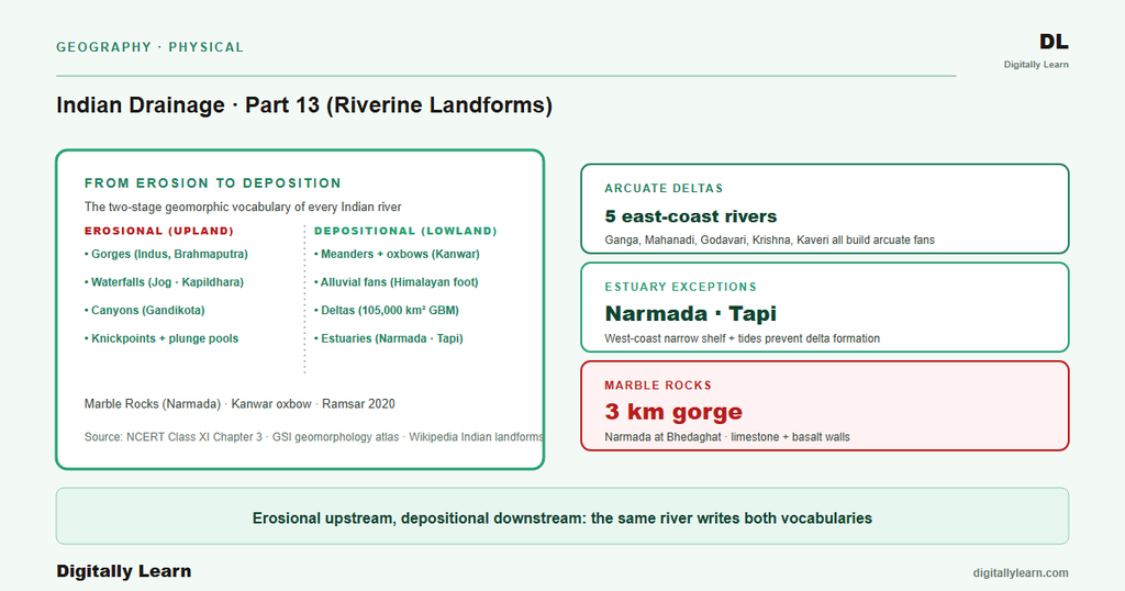
A Process-Based Typology of Riverine Landforms
Two Processes, Three Stages, One Classification System
Definition: Riverine landforms are the surface features produced by the combined action of a river on its bedrock and floodplain. Geomorphologists classify them into two process categories, depending on whether the river is removing material or laying it down.
Erosional landforms are produced by the removal of material through hydraulic action, abrasion, attrition, and corrosion; the standard examples are V-shaped valleys, gorges, waterfalls, potholes, and cut banks. Depositional landforms are produced by the laying down of material as the river loses energy; the standard examples are alluvial fans, natural levees, point bars, floodplains, deltas, and oxbow lakes.
Why it matters: This two-category framework is the working vocabulary of Indian geomorphology for the UPSC – CSE Prelims and Mains General Studies Paper I physical-geography syllabus. Every named feature in the previous parts of this series, from the Nanga Parbat gorges of the Indus (Part 4) to the Sundarbans delta of the Ganga (Part 8), is an instance of one category or the other.
Understanding the framework lets a student predict which landforms form in which reach of any given Indian river, and read the river's geomorphic history from the present landscape. The same logic links the Marble Rocks of the Narmada (Part 12) to the erosional class and the alluvial plains downstream to the depositional class.
How the Two Processes Map Onto the Youthful, Mature, and Senile River Reaches
What is the significance of this classification: The erosional-versus-depositional split maps directly onto the three-stage longitudinal profile covered in Part 5 of this series. The two classifications together explain why specific Indian landforms appear where they do along a river's course.
The youthful reach in the upper mountains is dominated by erosional features because the river has high energy and low sediment load. The mature reach in the foothills and middle plain shows a balance of erosional and depositional features. The senile reach in the coastal plain is dominated by depositional features because the river has low energy and high sediment load.
| Reach | Dominant process | Indian example |
|---|---|---|
| Youthful (mountain) | Erosional | Nanga Parbat gorge on the Indus |
| Mature (foothill and middle plain) | Mixed | Bhabhar fan, Brahmaputra braided plain |
| Senile (lower plain and coast) | Depositional | Ganga-Brahmaputra-Meghna delta |
Erosional Landforms: Gorges, Waterfalls, Potholes, and Cut Banks
V-Shaped Valleys, Gorges, Canyons, and Waterfalls
V-shaped valleys form in the youthful reach where the river cuts vertically into bedrock faster than it can widen laterally. The clearest Indian examples are the Himalayan antecedent gorges covered in Part 4: the Indus at Nanga Parbat cuts gorges four thousand five hundred to five thousand two hundred metres deep, and the Yarlung Tsangpo cuts canyon walls roughly five thousand metres high at Namcha Barwa.
The Marble Rocks at Bhedaghat near Jabalpur on the Narmada (covered in Part 12) form a gorge cut through soft white marble. The Gandikota canyon in the Kadapa district of Andhra Pradesh, often called the Grand Canyon of India, was carved by the Pennar river where it narrows through the Erramala range, and was tested by the 2022 UPSC – CSE Prelims.
Waterfalls form at lithological contrasts where harder rock overlies softer rock and the softer layer erodes back faster, leaving the harder layer overhanging. Jog Falls on the Sharavati in Karnataka, with a total height of about two hundred and fifty-three metres, is among the tallest plunge waterfalls in India.
Nohkalikai Falls in Meghalaya and Dudhsagar Falls on the Goa-Karnataka border are two further high Indian falls of comparable order. The Sivasamudram Falls on the Kaveri in Karnataka and the Hogenakkal Falls at the Karnataka-Tamil Nadu border are the standard Cauvery examples, while Kapildhara sits on the Narmada at Amarkantak.
Potholes, Plunge Pools, Rapids, and Cut Banks
Beyond gorges and waterfalls, the river cuts four additional erosional features along its course, each marking a different combination of channel slope and flow turbulence.
- (i) Potholes. Bowl-shaped depressions cut into bedrock by sediment-laden water swirling in eddies, accumulating at the base of waterfalls and along rocky channels.
- (ii) Plunge pools. Deeper basins immediately at the foot of waterfalls, scoured by the falling water.
- (iii) Rapids and cataracts. Turbulent reaches where the channel slopes steeply but no clean waterfall has formed.
- (iv) Cut banks. Concave outer-bend surfaces on meanders where lateral erosion is undermining the floodplain.
These four features mark the stretch where the river breaks down the bedrock and floodplain material that the depositional landforms covered in the next section then rebuild downstream. The cut bank, in particular, is the directly observable counterpart to the point bar across the river: the outer bank loses material that the inner bank gains. The asymmetric meander geometry covered in Part 8 of this series rests entirely on this cut-bank and point-bar pair.
Depositional Landforms: Fans, Levees, Point Bars, and Oxbows
Alluvial Fans, Bhabhar Aprons, and Braided Channels
Alluvial fans form at the mountain front where a river suddenly loses gradient and drops its coarsest sediment in a fan-shaped lobe. The Kosi alluvial fan in north Bihar is one of the largest in the world, with lateral channel shifting exceeding one hundred and twenty kilometres over about two hundred and fifty years through at least twelve major channels (recap from Parts 4 and 5).
The Bhabhar belt at the foot of the Himalayas (covered in Part 5) is a continuous coalesced alluvial fan running along the entire Himalayan front, where the gravel apron swallows the smaller streams before they re-emerge in the Terai.
Braided channels form where heavy bedload and a steep gradient cause the river to split into multiple sub-channels around mid-channel sediment bars. The Brahmaputra in its Assam reach (Part 9) is the textbook braided river, with the channel reaching up to twenty kilometres wide in parts.
The Majuli river island at the centre of the Assam reach is the world's largest inland river island (recap from Part 9). Braided geometry is the diagnostic depositional feature of the mature reach, where the bedload the river carries exceeds the channel's transport capacity.
Natural Levees, Point Bars, and Oxbow Lakes
Natural levees are ridges of fine sediment built up on either bank during overbank flow, when the flooded river drops its coarsest material immediately adjacent to the channel. Over centuries the river bed can rise above the surrounding plain, as seen on the lower Hooghly and the Kosi (recap from Parts 5 and 8).
Point bars are wedges of sand and silt deposited on the inner bend of meanders where the flow velocity is lowest. The asymmetric meander geometry rests on the point-bar-and-cut-bank pair covered in Section 2: the inner bank gains exactly the material the outer bank loses.
Oxbow lakes form when a meander loop is cut off during a flood, leaving an abandoned arc that fills with water. The Kanwar Lake (Kabartal) in Bihar (covered in Part 5) is the leading Indian example, formed by past meandering of the Burhi Gandak, a tributary of the Ganga. It is Asia's largest freshwater oxbow lake and Bihar's first Ramsar site, designated in 2020.
Smaller oxbow lakes punctuate the entire Indo-Gangetic plain along the meandering reaches of the Ganga, the Yamuna, and the Ghaghara. Each abandoned loop records a past position of the channel, so a chain of oxbows traces centuries of channel migration across the floodplain.
Deltas and Estuaries: How a River Ends
Three Morphological Delta Types and Why Most Indian Deltas Are Arcuate
Observable outcomes: Deltas are classified by morphological form into three principal types, distinguished by the shape of the seaward edge and the pattern of distributaries.
- (a) Arcuate deltas. A curved or fan-shaped seaward edge with multiple distributaries radiating from the apex; the Ganga-Brahmaputra-Meghna delta covered in Part 8 is the largest delta in the world, covering more than one hundred and five thousand square kilometres.
- (b) Bird-foot deltas. A few long narrow distributaries extending into the sea; the Mississippi delta of the United States is the standard example, with no major Indian counterpart.
- (c) Cuspate deltas. A wave-shaped seaward edge produced when strong wave action concentrates sediment along a single point; the Tiber delta of Italy and the Ebro delta of Spain are the standard examples.
Why most Indian deltas are arcuate: The dominant arcuate form reflects the balance between river sediment supply and Bay of Bengal tidal action. The Ganga, the Mahanadi (Part 10), the Godavari (Part 10), the Krishna (Part 11), and the Kaveri (Part 11) all build arcuate deltas with distributaries radiating from a delta apex.
The Bay of Bengal's wider continental shelf and weaker tidal action allow the arcuate geometry to stabilise. By contrast the Arabian Sea's narrow shelf and stronger tidal action prevent delta formation entirely for the Narmada and the Tapti (Part 12), which is why those rivers end in estuaries.
Estuaries: When the River Cannot Build a Delta
An estuary is a tidal mouth where the river meets the sea without building a depositional landform. The Narmada and the Tapti form estuaries at the Gulf of Khambhat (covered in Part 12). The 2004 UPSC – CSE Prelims tested this distinction through an Assertion-Reason question that turned on why these rivers carry no deltas.
The assertion that west-flowing Peninsular rivers have no deltas is correct, but the reason that they carry no alluvial sediment is incorrect. The actual cause combines three factors covered in Part 12: limited rift-confined sediment delivery, a narrow Arabian Sea coastal plain, and a steep continental shelf with strong tidal erosion. This estuary-versus-delta contrast shows how several factors must align before a river can build a delta at its mouth.
How Dams, Embankments, and Climate Change Are Reshaping Indian River Landforms
Sediment Starvation, Channel Aggradation, and Sea-Level Rise on the Indian Coast
Contemporary linkages: Three forward-looking pressures are reshaping the Indian landform record. First, dam-driven sediment starvation downstream is depriving Indian deltas of the sediment supply that built them; the Ganga delta and the Mahanadi delta both show measurable sediment-starvation signatures near their seaward margins (covered in Parts 8 and 10).
Second, embankment-induced channel aggradation raises river beds above the surrounding plain, increasing flood frequency and producing new floodplain features that depart from the pre-modification geometry. The Kosi avulsion of 2008 (Part 4) is the dramatic recent expression of this mechanism.
Third, climate change is shifting the precipitation regime that all Indian fluvial landforms depend on. Intensifying monsoon-pulse rainfall amplifies peak floods and the energy available for erosion, while the dry season grows longer and reduces the energy available for sediment transport. The combined effect is a partial reorganisation of the erosional-versus-depositional balance across every Indian river.
Sea-level rise additionally threatens the seaward edge of the arcuate deltas, particularly the Sundarbans (Part 8). Parts 14 and 15 close the series with drainage and the Indian economy plus river linking (Part 14), and the floods, pollution, conservation, and climate synthesis (Part 15).
Prelims MCQ practice
Each question below tests one specific concept on the topic. Click to reveal the answer and a full option-wise explanation.
Q1. Consider the following statements about erosional riverine landforms:
- V-shaped valleys form in the youthful reach where vertical incision exceeds lateral erosion.
- Waterfalls form at lithological contrasts where harder rock overlies softer rock.
- Point bars are erosional landforms on the outer bend of meanders.
Which of the statements given above are correct?
- 1 only
- 1 and 2 only
- 2 and 3 only
- 1, 2 and 3
Show answer and explanation
Answer: 1 and 2 only
Explanation.
Statements 1 and 2 match the NCERT typology. Statement 3 is incorrect: point bars are DEPOSITIONAL landforms on the INNER bend of meanders; cut banks are the erosional outer-bend feature.
Q2. Consider the following statements about Indian waterfalls and the rivers that feed them:
- Jog Falls, with a total height of about two hundred and fifty-three metres, lies on the Sharavati river in Karnataka.
- Sivasamudram Falls and Hogenakkal Falls both lie on the Kaveri river system.
- Kapildhara Falls lies on the Narmada at Amarkantak in Madhya Pradesh.
Which of the statements given above are correct?
- 1 only
- 1 and 2 only
- 2 and 3 only
- 1, 2 and 3
Show answer and explanation
Answer: 1, 2 and 3
Explanation.
Statement 1 is correct: Jog Falls is a plunge waterfall about two hundred and fifty-three metres high on the Sharavati in Karnataka. Statement 2 is correct: both Sivasamudram and Hogenakkal lie on the Kaveri (Cauvery) river. Statement 3 is correct: Kapildhara sits on the Narmada at Amarkantak. The three falls are linked to three different Peninsular and Western Ghat rivers.
Q3. Consider the following statements about depositional riverine landforms:
- An alluvial fan forms at the mountain front where the river suddenly loses gradient and drops its coarsest sediment.
- Natural levees are ridges of fine sediment built up on either bank during overbank flow.
- Oxbow lakes form when a meander loop is cut off during a flood, leaving an abandoned arc that fills with water.
Which of the statements given above are correct?
- 1 only
- 1 and 2 only
- 2 and 3 only
- 1, 2 and 3
Show answer and explanation
Answer: 1, 2 and 3
Explanation.
All three statements match the standard textbook definitions for alluvial fans, natural levees, and oxbow lakes.
Q4. Consider the following statements about delta classification:
- The Ganga-Brahmaputra-Meghna delta is the largest arcuate delta in the world.
- The Mississippi delta of the United States is a classic example of a bird-foot delta.
- Most Peninsular Indian east-flowing rivers, including the Mahanadi, Godavari, Krishna, and Kaveri, build cuspate deltas.
Which of the statements given above are correct?
- 1 only
- 1 and 2 only
- 2 and 3 only
- 1, 2 and 3
Show answer and explanation
Answer: 1 and 2 only
Explanation.
Statements 1 and 2 are correct. Statement 3 is incorrect: the Mahanadi, Godavari, Krishna, and Kaveri all build ARCUATE deltas, not cuspate. Cuspate deltas (Tiber, Ebro) are found in other parts of the world.
Q5. Consider the following statements about the no-delta geometry of west-flowing Peninsular rivers:
- The Narmada and the Tapti reach the Arabian Sea through estuaries rather than deltas.
- The narrow Arabian Sea coastal plain prevents delta formation by these rivers.
- The strong tidal action of the Arabian Sea erodes any nascent delta lobe before it can stabilise.
Which of the statements given above are correct?
- 1 only
- 1 and 2 only
- 2 and 3 only
- 1, 2 and 3
Show answer and explanation
Answer: 1, 2 and 3
Explanation.
All three statements are consistent with the structural explanation for why west-flowing Peninsular rivers form estuaries rather than deltas. The 2004 UPSC Prelims Assertion-Reason (covered in this article's PYQ section) confirms that lack of sediment is NOT the cause (the actual causes are listed in Statements 2 and 3 plus the rift-valley sediment-supply limitation covered in Part 12).
Sources
- India Physical Environment, Class 11, Chapter 3: Drainage System
- River Delta
- Jog Falls
- Gandikota
- Marble Rocks
- Kosi River
- Majuli
- Tectonic and Geomorphology Atlas of India
- Sediment yield annual reports for major Indian river basins
- Coastal Regulation Zone Notification 2019 and Integrated Coastal Zone Management documents
- Coastal zone management plans
- Riverine landform conservation releases
Disclaimer
This article is grounded in NCERT and standard physical-geography references on the erosional and depositional riverine landform classification, with named Indian examples drawn from across this drainage series. Figures for waterfall heights, gorge depths, basin areas, and delta extents follow those sources. Readers seeking the full geomorphology atlas should consult the Geological Survey of India.


