


Overview
A drainage system is the network of streams and channels through which the surface water of a region flows toward a single outlet such as a sea, lake or inland basin.
What is a Drainage System: Foundation Concepts
Drainage System as a Channelled Network with One Outlet
Definition: A drainage system is the network of streams, tributaries, distributaries, and underlying channels of a region. Surface water collected within that region flows through this network toward a single outlet, such as the sea, an inland lake, or a desert basin. The system is the spatial expression of how a landscape sheds water under gravity.
Channels arrange themselves into tree-like or trellised forms according to slope, geology, and rainfall regime. A drainage system is one of the foundational units of physical geography, alongside relief, climate, and soils.
Why it matters: Drainage frames everything from the location of cities to the spread of agriculture, the supply of drinking water, the dispersal of sediment, and the rhythm of floods and droughts. India hosts more than four hundred named rivers and a far larger number of seasonal streams. The country's economy and culture are organised along their valleys.
Understanding the drainage system explains why some plains are intensely cultivated while neighbouring uplands stay sparsely populated. The same framing explains why floods recur in some regions while others face perennial water scarcity. Drainage is therefore a master variable in Indian human geography.
What is the significance of the river basin as a planning unit: The river basin is the binding base for irrigation planning, river-basin management, and inter-state water sharing. It also underwrites hydropower siting, flood-control engineering, and groundwater recharge.
The Central Water Commission, the National Water Development Agency, and the Ministry of Jal Shakti all treat the river basin as the principal planning unit. This approach was reaffirmed by the National Ganga River Basin Authority framework, and it remains the basis of the National Mission for Clean Ganga.
- (i) Networked hierarchy: every drainage system is organised into orders, with first-order streams uniting into higher-order trunks per the Strahler stream-order scheme.
- (ii) Defined outlet: each system terminates at one outlet, either ocean (exorheic), interior basin (endorheic, as in the Luni system of Rajasthan), or a closed sink.
- (iii) Boundary by water divide: the system’s extent is delimited by ridge lines or watershed crests across which water flows to a different system.
Drainage Basin, Catchment Area, and Watershed Boundary
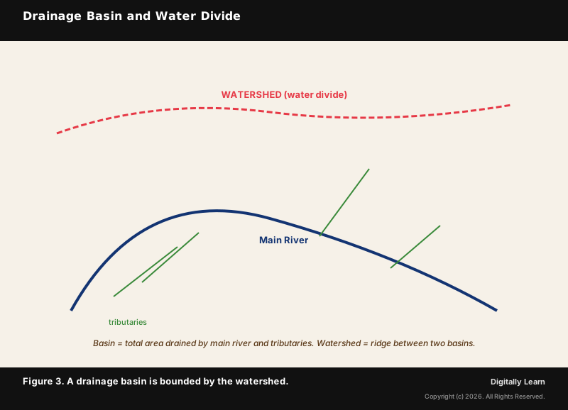
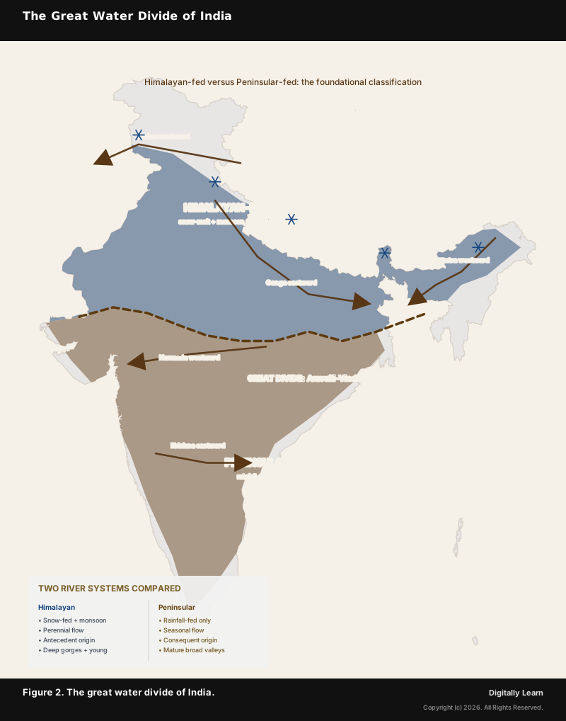
A drainage basin is the total land area drained by a river and its tributaries. The catchment area is functionally the same quantity, used in irrigation and water-resource planning. The watershed, or water divide, is the boundary line separating one basin from the next. In India, the Aravalli range forms part of the divide between the Indus and Ganga systems, while the Western Ghats divide separates the short west-flowing rivers from the long east-flowing Peninsular system.
Major Indian basins include the Ganga (the largest within India by area, around 8.6 lakh square kilometres), the Indus (a transboundary basin of roughly 11.2 lakh square kilometres, of which India holds about 39 per cent), the Brahmaputra, the Godavari, the Krishna, the Mahanadi, the Narmada, the Tapi, and the Kaveri.
| Concept | Definition | Indian example |
|---|---|---|
| Drainage system | Network of all channels emptying through one outlet | Ganga system draining into Bay of Bengal |
| Drainage basin | Total land area drained by a river and its tributaries | Ganga basin: ~8.6 lakh sq km |
| Catchment area | Equivalent to basin in irrigation/hydrology use | Hirakud reservoir catchment within Mahanadi basin |
| Watershed | Boundary or divide between two adjacent basins | Vindhya range: Ganga basin vs Narmada-Tapi basins |
| Outlet | Final exit of the drainage system | Sundarbans delta: Ganga-Brahmaputra outlet |
The river basin is the principal planning unit for water-resource management in India. The Central Water Commission has organised the country into twenty river basins for hydrological accounting. Sub-basins are then nested within them for command-area planning, environmental-flow assessment, and inter-state water sharing under the various river-basin authorities.
The Integrated Watershed Management Programme, launched in 2009-10 and subsumed into the Watershed Development Component of Pradhan Mantri Krishi Sinchayee Yojana in 2015-16, applies the watershed as the local planning unit. Its focus is rainfed-area development and soil-water conservation.
River as a Geomorphic Agent
Three Actions of a River: Erosion, Transport, Deposition
A river is the most important geomorphic agent on a continent. It performs three basic actions, namely erosion, transport, and deposition. The balance among them determines the shape of the resulting landscape.
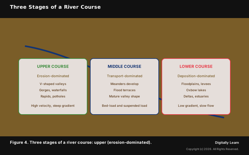
In the upper or youthful course, the river runs down steep gradients and erodes vigorously, producing V-shaped valleys, gorges, waterfalls, and rapids. In the middle or mature course, the gradient lessens and the river carries its load as bed-load and suspended sediment, building meanders and flood terraces.
In the lower or old course, the velocity drops and the river deposits its load. This builds floodplains, natural levees, oxbow lakes, alluvial fans, and finally deltas at the outlet.
- (a) Erosional landforms in the upper course: gorges (the Brahmaputra at Dihang), canyons, waterfalls (Jog falls of Sharavati, Hundru of Subarnarekha), rapids, plunge pools, and potholes.
- (b) Depositional landforms in the lower course: floodplains (Indo-Gangetic plain at the world’s largest scale), natural levees, oxbow lakes, deltas (Sundarbans, Mahanadi, Godavari, Krishna, Kaveri), and alluvial fans at piedmont contacts.
- (c) Long-profile evolution: the river continuously adjusts its long profile toward a graded condition, with a smooth concave-up curve from source to mouth.
River Course Stages: Upper, Middle, and Lower Reaches
Indian Drainage System Overview
Himalayan, Peninsular, and Inland: Three Indian Drainage Systems
Indian rivers fall into two great systems based on origin, geomorphic character, and flow regime. The Himalayan system comprises the Indus, the Ganga, and the Brahmaputra with their tributaries. These rise in the snow and glacier reserves of the Himalayan and Trans-Himalayan ranges and are mostly perennial.
The Peninsular system comprises the east-flowing Mahanadi, Godavari, Krishna, and Kaveri, plus the west-flowing Narmada and Tapi, the short Konkan and Malabar coastal rivers, and the inland Luni system of the Thar Desert. These rivers depend on monsoonal rainfall and are seasonal in regime.
| Feature | Himalayan rivers | Peninsular rivers |
|---|---|---|
| Source | Snow and glaciers of Greater Himalayas and Trans-Himalayas | Highlands of Peninsular plateau |
| Flow regime | Perennial (snowmelt and monsoon) | Seasonal (mostly monsoon-fed) |
| Valley shape | Deep gorges and V-shaped valleys in upper course | Shallow, broad mature valleys throughout |
| Catchment area | Very large (Ganga ~8.6 lakh sq km) | Smaller (Godavari ~3.1 lakh sq km) |
| Sediment load | High (active uplift and glacial scour) | Lower (stable hard-rock terrain) |
| Geomorphic age | Young, still actively downcutting | Mature, near-graded |
| Major deltas | Sundarbans (Ganga-Brahmaputra), Indus | Mahanadi, Godavari, Krishna, Kaveri |
| Course mobility | Highly mobile, frequent course change (Kosi) | Stable course, fixed channel |
A third, smaller component is the inland drainage system of the arid west. The Luni river of Rajasthan rises in the Aravalli foothills, flows through the Thar Desert, and disappears into the Rann of Kachchh without reaching the sea. Several ephemeral streams and salt-lake basins of Rajasthan and Gujarat fall in this endorheic category. Together the three components, Himalayan, Peninsular, and inland, account for the entire surface drainage of the Indian Subcontinent.
River Systems and Human Civilisation
Why River Basins Anchor Indian Civilisation and Policy
Contemporary linkages: Indian river basins host some of the world's most concentrated populations because they combine fertile alluvium, dependable water supply, transport corridors, and energy potential. The Indus Valley Civilisation flourished along the Indus and the now-dry Saraswati in its mature phase between roughly 2600 and 1900 BCE.
The Gangetic civilisations followed from the first millennium BCE onwards, building cities such as Varanasi, Patna (ancient Pataliputra), and Prayagraj at confluences and bathing ghats. The river basin therefore frames not only physical geography but also history, religion, and modern policy.
The contemporary debate over the National River Linking Project, the Namami Gange mission, and the Inter-State Water Disputes Tribunal architecture converges on the drainage system as the central operating unit. Glacier retreat in the Himalayas now adds a long-horizon stress to that same basin geography.
Subsequent parts of this series develop these threads. Part 2 surveys drainage patterns, Part 4 traces the geological evolution of Indian drainage, and Part 5 opens the Himalayan system in detail.
Previous Year UPSC-CSE Questions
Previous Year UPSC-CSE Questions By the end you will be able to draft model answers for the following UPSC questions. Each question carries a collapsible framework showing how to approach it in the exam.
- Prelims 2016Which of the following are the key features of 'National Ganga River Basin Authority (NGRBA)'?
- River basin is the unit of planning and management.
- It spearheads the river conservation efforts at the national level.
- One of the Chief Ministers of the States through which the Ganga flows becomes the Chairman of NGRBA on rotation basis. Select the correct answer using the code given below:
How to approach this Prelims question
Approach: Eliminate the false statement: NGRBA Chairman is the Prime Minister (not a rotating Chief Minister). Statements 1 and 2 are core to NGRBA design.
Trap to watch: Statement 3 sounds plausible (CMs are members) but the Chairmanship is fixed with the PM, not rotating.
Key facts to recall:
- NGRBA constituted 2009
- Chairman = PM
- river basin = planning unit
- subsumed into National Mission for Clean Ganga (NMCG) framework.
Answer signal: (a) 1 and 2 only
- Prelims 2014What are the benefits of implementing the 'Integrated Watershed Development Programme'?
- Prevention of soil runoff
- Linking the country's perennial rivers with seasonal rivers
- Rainwater harvesting and recharge of groundwater table
- Regeneration of natural vegetation
Select the correct answer using the code given below.
How to approach this Prelims question
Approach: Identify the misplaced item: river-linking is a separate national project, not an IWMP component. IWMP focuses on local watershed scale.
Trap to watch: Statement 2 mixes IWMP (local watershed unit) with NRLP (inter-basin transfer). Always separate scales.
Key facts to recall:
- IWMP launched 2009-10, subsumed under PMKSY-WDC 2015
- Focuses on rainfed soil-water conservation, not inter-basin transfer.
Answer signal: (c) 1, 3 and 4 only
- Prelims 2008Consider the following pairs: Tributary River – Main River
- Chambal : Narmada
- Sone : Yamuna
- Manas : Brahmaputra Which of the pairs given above is/are correctly matched?
How to approach this Prelims question
Approach: Validate each pair against standard drainage maps. Pair 1 Chambal:Narmada is WRONG (Chambal is a Yamuna tributary). Pair 2 Sone:Yamuna is WRONG (Sone is a Ganga tributary, not Yamuna). Pair 3 Manas:Brahmaputra is CORRECT (Manas drains into Brahmaputra). Only pair 3 is correctly matched.
Trap to watch: Pairs 1 and 2 look superficially plausible (both are major Gangetic-system rivers) but are deliberately swapped. Chambal flows into Yamuna; Sone flows into Ganga.
Key facts to recall:
- Chambal: Yamuna tributary (joins at Etawah, Uttar Pradesh)
- Sone: Ganga tributary (joins near Patna)
- Manas: Brahmaputra tributary (joins in lower Assam)
- Major Ganga tributaries: Yamuna, Ghaghara, Gandak, Kosi, Son
Answer signal: (d) 3 only
- UPSC Mains 2015 GS-IIIDiscuss the Namami Gange and National Mission for Clean Ganga (NMCG) programmes and causes of mixed results from the previous schemes. What quantum leaps can help preserve the river Ganga better than incremental inputs?
How to structure the answer in the exam
Introduction: Open with the river basin as the planning unit reaffirmed by NGRBA 2009 and operationalised by NMCG. State that Namami Gange (launched 2014) consolidates earlier Ganga Action Plan efforts under a basin-scale architecture.
Conclusion: Close with the structural shift from project-scale to basin-scale governance as the durable contribution of NMCG, conditional on enforcement of e-flow norms and central-state coordination.
Sources
- NCERT Class 11 India Physical Environment, Chapter 3 (Drainage System), pp 27-37
- Ministry of Jal Shakti, Department of Water Resources, River Development and Ganga Rejuvenation
- Central Water Commission (CWC)
- India Water Resources Information System (India-WRIS)
- National Water Development Agency (NWDA)
- National Institute of Hydrology (NIH), Roorkee
- National Mission for Clean Ganga (NMCG / Namami Gange)
- Ministry of Environment, Forest and Climate Change
- Wikipedia: Drainage system (geomorphology)
- Wikipedia: List of rivers of India
Disclaimer
This article is a study aid for UPSC preparation, grounded in NCERT and the official sources cited. River basin areas and tributary lists draw on Central Water Commission and India-WRIS data; readers preparing for Prelims should cross-check the standard NCERT figures.