

Overview
Course, tributaries, dams and the water disputes
The Kaveri River, spelled Cauvery in the names of its tribunal, its management authority and the water dispute, and in UPSC's questions, rises at Talakaveri in the Brahmagiri hills of Kodagu, Karnataka, and flows about 800 km to the Bay of Bengal. The Krishna River rises near Mahabaleshwar in Maharashtra and flows 1,401 km, the second largest east-flowing river of the Peninsula after the Godavari. Together they drain most of the southern Deccan, feed some of India's oldest irrigation works and carry two of its longest inter-State water disputes.
East-Flowing Rivers of the Peninsula
Why Peninsular Rivers Flow East
The Western Ghats run close to the west coast and act as the water divide of the Peninsula. They send a few short rivulets to the Arabian Sea and hand the long rivers to the Bay of Bengal. The eastward slope comes from the slight tilting of the Peninsular block from the north-west to the south-east, which oriented the whole drainage towards the Bay. Most major Peninsular rivers except the Narmada and the Tapi therefore flow from west to east, and the Mahanadi, Godavari, Krishna and Kaveri are the large river systems among them.
Peninsular rivers have a fixed course, little meandering and mostly non-perennial flow. The Narmada and the Tapi flow west instead because they run through rift valleys to the Arabian Sea.
A river's direction follows the slope it drains, not the State in which it rises. Most rivers of Kerala flow west to the Arabian Sea, yet the Kabini rises in Wayanad district of Kerala and flows east to join the Kaveri in Karnataka. In the same way, the Narmada rises on the Amarkantak plateau in Madhya Pradesh and flows west to the Gulf of Khambhat.
Kaveri River and Krishna River Compared
The two rivers are close neighbours but behave differently. The Krishna is the longer river and carries most of its water in the south-west monsoon. The Kaveri is shorter, but it is fed by both monsoons and keeps flowing through the year.

| Feature | Krishna | Kaveri |
|---|---|---|
| Source | Near Mahabaleshwar in the Sahyadri, about 1,300 m | Talakaveri, Brahmagiri hills, Kodagu, 1,341 m |
| Length | 1,401 km | About 800 km |
| Basin area | 2,58,948 sq km | 81,155 sq km |
| Basin share | Maharashtra 27, Karnataka 44, Andhra Pradesh and Telangana 29 per cent | Kerala 3, Karnataka 41, Tamil Nadu 56 per cent |
| Chief tributaries | Koyna, Bhima, Tungabhadra, Ghataprabha, Malaprabha, Musi | Hemavati, Kabini, Shimsha, Arkavati, Bhavani, Noyyal, Amaravati |
| Mouth | Bay of Bengal, Andhra Pradesh coast | Bay of Bengal near Poompuhar, Tamil Nadu |
| Tribunal | Krishna Water Disputes Tribunal: KWDT‑I (1969) and KWDT‑II (2004) | Cauvery Water Disputes Tribunal (1990) |
Mahanadi, Godavari, Pennar and Vaigai Beside the Krishna and Kaveri
A comparison with the neighbouring east-flowing rivers fixes the geography of the whole coast. The Mahanadi rises in Chhattisgarh near Sihawa, runs through Odisha and is 851 km long. The Godavari is the largest Peninsular river system, called the Dakshin Ganga, 1,465 km long with a catchment of 3.13 lakh sq km. The Pennar rises in the Nandi Hills of Karnataka, is 597 km long and forces its way through the Gandikota gorge in the Eastern Ghats before it enters the plains of coastal Andhra Pradesh. The Vaigai of Tamil Nadu drains to Palk Bay.
Reading the mouths from north to south gives the order UPSC asked in 2002: Subarnarekha, Mahanadi, Godavari, Krishna, Pennar, Kaveri and Vaigai. The Manjira, a tributary of the Godavari, belongs to a different river system from the Pennar, which matters for questions on the Gandikota canyon.
Krishna River: Origin, Course, Basin and Tributaries
Krishna River Origin and Course Through Four States
The Krishna rises in the Western Ghats near Mahabaleshwar in Satara district of Maharashtra, at about 1,300 m, and flows to the town of Wai before it turns east across the Deccan. Its length of 1,401 km is shared roughly as 305 km in Maharashtra, 483 km in Karnataka and 612 km in Andhra Pradesh and Telangana. It passes through all four States and enters the Bay of Bengal through its delta on the coast of Andhra Pradesh.
Three tributaries, the Panchganga, Warana and Yerla, meet the Krishna near Sangli. Further downstream, at Kudalasangama in Bagalkote district of Karnataka, about 15 km from the Almatti Dam, the Krishna receives the Malaprabha. The river then flows east towards Srisailam, where it cuts a deep gorge through the Nallamala Hills, and then past Nagarjuna Sagar and Vijayawada to the sea.
Krishna Basin: Area, Water, Minerals and the Delta
The Krishna basin covers 2,58,948 sq km, nearly 8 per cent of the geographical area of India, and is the fifth largest river basin in the country. By area, Karnataka holds 1,13,271 sq km, Andhra Pradesh with Telangana 76,252 sq km and Maharashtra 69,425 sq km. The soils are black, red and laterite, and the basin has an average annual surface water potential of 78.1 cubic km, of which 58.0 cubic km is usable.
The Krishna-Godavari delta is known as the Rice Granary of India. The last surviving mangroves of the Krishna estuary are protected as the Krishna Wildlife Sanctuary, and the Nagarjunsagar-Srisailam Tiger Reserve lies in the basin. Below the ground the basin holds oil and gas in the Krishna-Godavari Basin, coal at Yellandu, uranium in Nalgonda and diamonds at Kollur. Since 2015 Godavari water has reached the Krishna through the Polavaram right bank canal, which ends at the Prakasam Barrage, a working link between the two basins.
Krishna River Tributaries: Koyna, Bhima and Tungabhadra
The Krishna has 13 major tributaries. Those on the right bank include the Koyna, Panchganga, Dudhganga, Ghataprabha, Malaprabha and Tungabhadra, and those on the left bank the Yerla, Bhima, Dindi, Musi, Paleru and Munneru. The Koyna, the Tungabhadra and the Bhima are the major ones.
- Koyna: Rises at Mahabaleshwar and joins from the right bank; the Koyna hydroelectric project stands on it.
- Bhima: The longest tributary, 861 km, rising at Bhimashankar and draining 70,614 sq km. It is called the Chandrabhaga at Pandharpur, the pilgrim town of Maharashtra.
- Tungabhadra: 531 km long, formed where the Tunga and the Bhadra meet at Koodli.
- Ghataprabha and Malaprabha: Right-bank rivers of north Karnataka; the Malaprabha meets the Krishna at Kudalasangama.
- Musi, Dindi, Paleru and Munneru: Left-bank rivers draining the plateau of Telangana and Andhra Pradesh.
Tungabhadra River, Hampi and the Tungabhadra Dam
The Tungabhadra is formed by two rivers, the Tunga and the Bhadra, which both rise on the eastern slope of the Western Ghats in Chikmagalur district and meet at Koodli in Karnataka. It flows past Harihara, Hospet, Hampi, Kampli, Mantralayam and Kurnool to join the Krishna near Gundimalla village in Telangana. At Hampi the river runs between granite hills, and the ruins of the capital of the Vijayanagara empire stand on its bank.
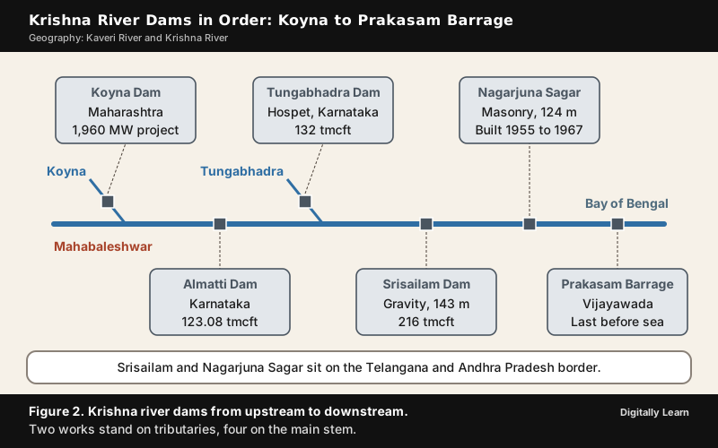
The Tungabhadra Dam near Hospet was built between 1949 and 1953 and stores 132 tmcft (thousand million cubic feet). It is owned by Karnataka and run by the Tungabhadra Board, because its water is shared with Andhra Pradesh and Telangana downstream.
Krishna River Dams: Koyna, Almatti, Srisailam and Nagarjuna Sagar
Koyna Dam and Almatti Dam
The Koyna Dam is a rubble-concrete dam on the Koyna River in Satara district, 103.2 m high, begun in 1956 and opened in 1964. It forms the Shivasagar lake. The Koyna hydroelectric project, with an installed capacity of 1,960 MW, is one of the largest hydroelectric power plants in India, and the river is called the lifeline of Maharashtra. The dam is also known for the 1967 Koynanagar earthquake, after which it had to be strengthened.
The Almatti Dam in north Karnataka was completed in July 2005 and is the main reservoir of the Upper Krishna Irrigation Project. It has a 290 MW power station on its right side and stores 123.08 tmcft at 519 m. It stands on the Krishna itself, not on a tributary, which is the fact UPSC tested in 1997.
Nagarjuna Sagar Dam: River, State and History
Nagarjuna Sagar Dam is built across the Krishna River at Nagarjuna Sagar, on the border between Nalgonda district of Telangana and Palnadu district of Andhra Pradesh, and both States draw irrigation water from its canals. It is a masonry dam, 124 m tall from its deepest foundation and 1.6 km long, with 26 flood gates. It was built between 1955 and 1967 and has a gross storage of 11.472 billion cubic metres. Prime Minister Nehru laid the foundation on 10 December 1955, and Prime Minister Indira Gandhi released water into the canals on 4 August 1967.
Nagarjuna Sagar was the first in a series of major projects of independent India called "modern temples". Its reservoir drowned the ancient Buddhist settlement of Nagarjunakonda, where excavations had yielded 30 Buddhist monasteries. Before the flooding the monuments were excavated and moved to higher ground on the old hill, which is now an island in the reservoir with a museum of the finds.
Srisailam Dam, Prakasam Barrage and the Dam Sequence
Srisailam Dam is a gravity dam across the Krishna in the Nallamala Hills near the temple town of Srisailam, between Nandyal district of Andhra Pradesh and Nagarkurnool district of Telangana. It is 143 m high and 512 m long and stores 216 tmcft. Its right-bank power house has seven 110 MW turbines and the left-bank underground house six 150 MW reversible pump turbines. The Mallikarjuna Jyotirlinga stands at Srisailam.
From upstream to downstream the main works of the Krishna system are the Koyna Dam on the Koyna, Almatti, the Tungabhadra Dam on the Tungabhadra, Srisailam, Nagarjuna Sagar and the Prakasam Barrage at Vijayawada. The barrage is the last structure before the sea, and its irrigation canals form part of National Waterway 4.
Kaveri River: Origin, Course, Delta and Tributaries
Kaveri River Origin and Course in Karnataka
The Kaveri rises at Talakaveri in the Brahmagiri hills of Kodagu district, Karnataka, at 1,341 m. It enters the Deccan through a narrow gorge, dropping 18 to 24 m at the Chunchanakatte Falls, and forms the river island of Srirangapatna. Further on the river drops 91 m at Shivanasamudra and passes through the Mekedatu gorge. It covers about 320 km in Karnataka and then forms the Karnataka-Tamil Nadu border for about 64 km.
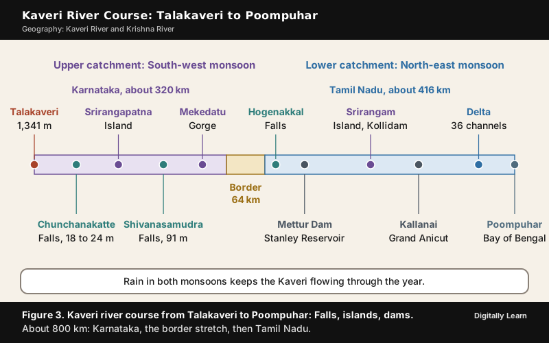
The Shivanasamudra Falls lie in Malavalli taluk of Mandya district and have two series of drops, Gagana Chukki and Bhara Chukki. The hydroelectric station beside them was established in 1902. Two other falls are often paired with it in questions: Jog Falls is on the Sharavati in Karnataka, and Kapildhara is a fall of the Narmada near its source at Amarkantak. The Kaveri forks and reunites three times, forming the islands of Srirangapatna, Shivanasamudra and Srirangam, which UPSC asked about in 1996.
Kaveri River in Tamil Nadu: Hogenakkal, Mettur and the Delta
On entering Tamil Nadu the Kaveri forms the Hogenakkal Falls and flows south to the Mettur Dam, after which the Bhavani joins it from the right at Kooduthurai. It then flows east past Erode and Karur into Tiruchirappalli district. There it divides into the northern Kollidam and the southern Kaveri, which enclose the island of Srirangam, and then spreads across a delta of 36 distribution channels before reaching the sea near Poompuhar. The river runs about 416 km in Tamil Nadu.
The two monsoons explain why the Kaveri keeps flowing when other Peninsular rivers shrink. The upper catchment in Karnataka gets its rain from the south-west monsoon in summer, and the lower catchment in Tamil Nadu from the north-east monsoon in winter, so the river carries water through the year with comparatively less fluctuation. In Tamil classical literature it is Ponni, the golden one, and it is revered as one of the seven sacred rivers.
Kaveri River Tributaries and Protected Areas of the Basin
The Kaveri has 21 major tributaries. In Karnataka the Harangi, Hemavati, Lakshmana Tirtha and Kabini join it, and the Shimsha and Arkavati enter before the river reaches Tamil Nadu. In Tamil Nadu it receives the Bhavani at Kooduthurai, and then the Noyyal, Amaravati, Sarabanga and Thirumanimutharu. The Kabini, the Bhavani and the Amaravati are the important ones.
The Kabini rises in Wayanad district of Kerala from the confluence of the Panamaram and Mananthavady rivers and flows east into Karnataka to meet the Kaveri. Its reservoir separates Nagarhole National Park from Bandipur, and the Moyar and Bhavani rivers flank the Sathyamangalam Tiger Reserve. Wayanad Wildlife Sanctuary lies in Wayanad district, where the Kabini rises, and is bounded by Nagarhole and Bandipur in Karnataka and Mudumalai in Tamil Nadu. Papikonda National Park, in contrast, lies in the East and West Godavari districts and belongs to the Godavari.
Kaveri River Dams and Ancient Irrigation Works
Krishna Raja Sagara Dam and Mettur Dam
The Krishna Raja Sagara, near Mysuru in Mandya district, is a gravity dam 39.8 m high and 2,620 m long, begun in 1911 and opened in 1932. Krishna Raja Wadiyar IV, Maharaja of Mysore, sanctioned it during a famine, and it stands just below the meeting of the Kaveri with the Hemavati and Lakshmana Tirtha. The Brindavan Gardens lie below it.
The Mettur Dam in Tamil Nadu, finished in 1934 after nine years, stands where the Kaveri enters the plains. It is 1,700 m long, stores about 93.5 tmcft in the Stanley Reservoir and receives water from its own catchment and from the Kabini and Krishna Raja Sagara dams in Karnataka. It is the largest dam in Tamil Nadu and supplies irrigation and drinking water to more than 12 districts. Because much of Mettur's water comes from releases by Karnataka's dams, the inflow at the border decides how well the delta's crop season goes.
Kallanai and the Grand Anicut
Kallanai, literally "stone dam", also called the Grand Anicut, is an ancient dam across the Kaveri in Thanjavur district, built by the Chola king Karikala. Made of unhewn stone, it is 329 m long and is the fourth oldest water-diversion or water-regulator structure in the world, still in good condition. The British remodelled it in the 19th century. In 1804 Captain Caldwell studied the river and found that too much water went into the Kollidam and too little into the delta channels. Kallanai also supplied a model to later engineers, including Sir Arthur Cotton, whose 19th-century Lower Anicut across the Kollidam is said to replicate it.
Inter-State River Water Disputes: Article 262 and the 1956 Act
Water Dispute Adjudication: Constitutional Basis and Procedure
Water is a State subject (Entry 17, State List), but the regulation and development of inter-State rivers can be taken up by the Union under Entry 56 of the Union List. Article 262 of the Constitution provides for the adjudication of disputes relating to waters of inter-State rivers or river valleys. Clause (1) lets Parliament by law provide for the adjudication of any dispute or complaint about the use, distribution or control of such waters. Clause (2) lets Parliament provide that neither the Supreme Court nor any other court will exercise jurisdiction over such a dispute.
Parliament used this power in the Inter-State River Water Disputes Act, 1956. The sequence under the Act is:
- A State government makes a complaint to the Centre under Section 3.
- If negotiation fails, the Centre constitutes a Water Disputes Tribunal under Section 4.
- The tribunal gives its report and decision under Section 5(2), and a further report under Section 5(3) if the States or the Centre seek clarification.
- The decision is published in the Official Gazette, after which it is equal to a decree of the Supreme Court, and violating it amounts to contempt of the Court.
- The Centre may frame a scheme under Section 6A to give effect to the decision, which is how the Cauvery Water Management Authority came into being.
Section 11 bars the Supreme Court and other courts from jurisdiction over a water dispute that may be referred to a tribunal. Even so, the Supreme Court held on 26 April 1991 (State of Tamil Nadu v. State of Karnataka) that it could decide the scope of the tribunal's powers, and in 2018 it decided the Cauvery appeals against the award itself. The Act was last amended in 2002.
Water Disputes Tribunals and the Single-Tribunal Bill
Eight tribunals were set up under the Act by 2010 for inter-State river water disputes: Godavari (1969), Krishna I (1969), Narmada (1969), Ravi and Beas (1986), Cauvery (1990), Krishna II (2004), Vansadhara (2010) and Mahadayi (2010). Each is an ad hoc body set up for one dispute, and the delays are long, which is the reason for the reform proposals.
The Inter-State River Water Disputes (Amendment) Bill, 2019, approved by the Cabinet on 10 July 2019, would have replaced the separate tribunals with a single tribunal with benches, and set up a Dispute Resolution Committee to try negotiation first. The Bill passed the Lok Sabha but lapsed because it was not approved before the new Lok Sabha was elected in 2024; an earlier Bill of 2017 had proposed the same and also lapsed. The 1956 Act as amended in 2002 therefore remains in force, and each dispute still needs its own tribunal.
Cauvery Water Dispute: Tribunal, Award and Supreme Court
Origins of the Cauvery Dispute: The 1892 and 1924 Agreements
The Cauvery dispute between Karnataka and Tamil Nadu is older than both States. In 1807 the Madras Presidency wrote to the princely state of Mysore about its use of Kaveri water, and a conference in 1890 led to an agreement in 1892. When Mysore planned a dam at Kannambadi, the future Krishna Raja Sagara, in 1910, Madras opposed it because it planned its own dam at Mettur. The matter went to arbitration, and the award of 12 May 1914 allowed Mysore a capacity of 11 tmcft. The appeal by Madras led to the agreement of 1924, under which Mysore built the Krishna Raja Sagara and Madras built the Mettur Dam.

The States were reorganised on linguistic lines in 1956, and parts of the basin passed to Kerala and Puducherry. The 1924 agreement expired in 1974. Karnataka argued that the pre-Independence agreements favoured the Madras Presidency and sought a fresh settlement; Tamil Nadu pointed to about 3 million acres of land under cultivation that depended on the river. Years of talks produced no settlement.
Cauvery Water Disputes Tribunal and the 2007 Award
On 4 May 1990 the Supreme Court directed the Centre to set up the tribunal, and the three-member Cauvery Water Disputes Tribunal was constituted on 2 June 1990, with Kerala, Karnataka, Tamil Nadu and Puducherry as parties. The States asked for very different shares: Tamil Nadu 566 tmcft, Karnataka 465, Kerala 99.8 and Puducherry 9.3. The tribunal gave an interim award on 25 June 1991 and its final award on 5 February 2007, which the Government notified on 20 February 2013.
| Party | Tribunal, 2007 (tmcft) | Supreme Court, 2018 (tmcft) |
|---|---|---|
| Tamil Nadu | 419 | 404.25 |
| Karnataka | 270 | 284.75 |
| Kerala | 30 | 30 |
| Puducherry | 7 | 7 |
Out of its share, Tamil Nadu was to release at least 10 tmcft for minimum environmental flows below the Lower Anicut on the Kollidam (the Lower Coleroon Anicut of the award), and Karnataka was to release a stipulated amount each month at the inter-State border.
Supreme Court Verdict of 2018, CWMA and CWRC
On 16 February 2018 the Supreme Court raised Karnataka's share by 14.75 tmcft to 284.75 and cut Tamil Nadu's to 404.25, leaving Kerala and Puducherry unchanged. The tribunal's award merged with the judgment, and the normal-year delivery at the Billigundlu gauge on the border was reduced from 192 to 177.25 tmcft. The Court told the Centre to frame a scheme under Section 6A; its order of 18 May 2018 approved the scheme, and on 1 June 2018 the Centre notified the Cauvery Water Management Authority (CWMA) and the Cauvery Water Regulation Committee (CWRC).
- CWMA: A chairman with a five-year tenure and two whole-time members, set up to give effect to the award as modified by the Court.
- CWRC: Headquartered at Bengaluru, it collects daily levels, inflows and storage at eight reservoirs: Hemavati, Harangi, Krishna Raja Sagara, Kabini, Mettur, Bhavanisagar, Amaravati and Banasurasagar.
The dispute did not end with the judgment. Observed flows at Billigundlu in 2019‑20 were 275.401 tmcft against the stipulated 177.25 tmcft, with June and July short and the later monsoon months in surplus, which is why the problem returns every dry June. In August 2023 Tamil Nadu asked Karnataka to release 24,000 cusecs a day; Karnataka refused, citing shortage, and protests followed in both States. Karnataka's Mekedatu balancing reservoir cum drinking water project is a further point of conflict. Its Detailed Project Report went to the Central Water Commission in January 2019 and was sent to the CWMA for the consent of the co-basin States.
Krishna Water Dispute: KWDT‑I, KWDT‑II and Telangana
Krishna Water Disputes Tribunal I: The Bachawat Award
The Centre constituted the Krishna Water Disputes Tribunal (KWDT) in April 1969 under the 1956 Act for the Krishna dispute among Maharashtra, Karnataka and Andhra Pradesh, with R. S. Bachawat as chairman. Its report came in 1973, and the award was published in the Extraordinary Gazette of 31 May 1976.
The tribunal worked at 75 per cent dependability, a flow that is available in three years out of four. It assessed 2,060 tmcft for distribution and divided it as Maharashtra 560, Karnataka 700 and Andhra Pradesh 800 tmcft; this division is known as Scheme A. Scheme B, which would have shared the surplus of 330 tmcft in the ratio 25:50:25 under a Krishna River Valley Authority, was dropped because creating such an authority was beyond the powers of a tribunal under the Act. The award could be reviewed after 31 May 2000.
Krishna Water Disputes Tribunal II, Telangana and the Present Position
In April 2004 the Centre constituted the second tribunal at the request of the three States, chaired by Justice Brijesh Kumar. It submitted its report and decision under Section 5(2) on 30 December 2010. Working at 65 per cent dependability, it allocated 1,001 tmcft to Andhra Pradesh, 911 to Karnataka and 666 to Maharashtra. The States and the Centre sought clarification, and a further report under Section 5(3) followed on 29 November 2013.

Andhra Pradesh challenged the 2010 decision, and on 16 September 2011 the Supreme Court directed that it should not be published in the Gazette until further orders, so the second award remains unnotified. The Andhra Pradesh Reorganisation Act, 2014, created Telangana on 2 June 2014 and, under Section 89, extended the tribunal's term to settle project-wise allocations and an operating protocol for deficit years.
Telangana complained to the Centre on 14 July 2014, and on 4 October 2023 the Union Cabinet approved further terms of reference so that the tribunal could decide between Telangana and Andhra Pradesh. The tribunal's term has been extended a year at a time since 2024, and its decision on these terms is still awaited.
Between Andhra Pradesh and Telangana, the Krishna River Management Board (KRMB), set up under the 2014 Act, manages and regulates the waters of the Krishna basin in the two States, which share the water available in a year in the ratio of 512:299 under an understanding between them.
Previous Year UPSC‑CSE Questions
Each Prelims question is explained option by option, and each Mains question comes with an answer outline.
- UPSC Prelims 2022Gandikota canyon of South India was created by which one of the following rivers?
How to approach this Prelims question
Approach: The canyon belongs to the river that cuts through the Eastern Ghats at Gandikota.
- Step 1: The Pennar meets its tributary the Chitravati near Gandikota.
- Step 2: It then forces its way through the Gandikota gorge in the Eastern Ghats to reach coastal Andhra Pradesh.
Trap to watch: The Tungabhadra's gorge at Hampi is the better-known canyon of the region.
Why each option is right or wrong:
- (a) Cauvery: Wrong. Its gorges are at Shivanasamudra, Mekedatu and Hogenakkal in Karnataka and Tamil Nadu.
- (b) Manjira: Wrong. It is a tributary of the Godavari, a different river system.
- (c) Pennar: Correct. The Pennar cuts the Gandikota gorge through the Eastern Ghats.
- (d) Tungabhadra: Wrong. It runs between granite hills at Hampi, not at Gandikota.
Answer: (c) Pennar. The Gandikota gorge is on the Pennar.
- UPSC Prelims 2020Which of the following Protected Areas are located in Cauvery basin?
- Nagarhole National Park
- Papikonda National Park
- Sathyamangalam Tiger Reserve
- Wayanad Wildlife Sanctuary
Select the correct answer using the code given below:
How to approach this Prelims question
Approach: Each protected area lies in the basin of the river that drains it.
- Step 1: Nagarhole lies on the Kabini reservoir, and the Kabini is a Kaveri tributary, so item 1 is in the basin.
- Step 2: Papikonda lies in the East and West Godavari districts, so item 2 belongs to the Godavari.
- Step 3: Sathyamangalam is flanked by the Moyar and the Bhavani, both on the Kaveri system, so item 3 is in the basin.
- Step 4: Wayanad sanctuary lies in Wayanad district, where the Kabini rises, so item 4 is in the basin.
Trap to watch: All four are protected areas of southern India, which tempts option (d).
Why each option is right or wrong:
- (a) 1 and 2 only: Wrong. Papikonda is a Godavari park, and Sathyamangalam and Wayanad are left out.
- (b) 3 and 4 only: Wrong. Nagarhole, on the Kabini reservoir, is also in the basin.
- (c) 1, 3 and 4 only: Correct. Nagarhole, Sathyamangalam and Wayanad all lie in the Cauvery basin.
- (d) 1, 2, 3 and 4: Wrong. Papikonda lies in the Godavari districts.
Answer: (c) 1, 3 and 4 only. Papikonda belongs to the Godavari; the other three to the Kaveri.
- UPSC Prelims 2019Consider the following pairs:Famous place | River
- Pandharpur : Chandrabhaga
- Tiruchirappalli : Cauvery
- Hampi : Malaprabha
Which of the pairs given above are correctly matched?
How to approach this Prelims question
Approach: Each pair is tested against the river that flows past the place.
- Step 1: Pandharpur stands on the Bhima, which is called the Chandrabhaga there, so pair 1 is right.
- Step 2: Tiruchirappalli stands on the Kaveri, which divides around Srirangam there, so pair 2 is right.
- Step 3: Hampi stands on the Tungabhadra, while the Malaprabha meets the Krishna at Kudalasangama, so pair 3 is wrong.
Trap to watch: The Malaprabha and the Tungabhadra are both Krishna tributaries in north Karnataka, which makes the third pair look right.
Why each option is right or wrong:
- (a) 1 and 2 only: Correct. Pandharpur is on the Chandrabhaga (Bhima) and Tiruchirappalli on the Cauvery.
- (b) 2 and 3 only: Wrong. Hampi is on the Tungabhadra, not the Malaprabha, and pair 1 is also right.
- (c) 1 and 3 only: Wrong. Pair 2 is right and pair 3 is wrong.
- (d) 1, 2 and 3: Wrong. Pair 3 fails because Hampi is on the Tungabhadra.
Answer: (a) 1 and 2 only. Hampi stands on the Tungabhadra, not the Malaprabha.
- UPSC Prelims 2009Consider the following statements:
- There are no east flowing rivers in Kerala.
- There are no west flowing rivers in Madhya Pradesh.
Which of the statements given above is/are correct?
How to approach this Prelims question
Approach: Each statement is tested against one river that breaks the rule it states.
- Step 1: Statement 1 is false, because the Kabini rises in Wayanad district of Kerala and flows east to join the Kaveri.
- Step 2: Statement 2 is false, because the Narmada rises at Amarkantak in Madhya Pradesh and flows west to the Gulf of Khambhat.
Trap to watch: Most rivers of Kerala do flow west, which makes statement 1 look true.
Why each option is right or wrong:
- (a) 1 only: Wrong. Kerala's Kabini flows east to the Kaveri.
- (b) 2 only: Wrong. The Narmada flows west through Madhya Pradesh.
- (c) Both 1 and 2: Wrong. Both statements are false.
- (d) Neither 1 nor 2: Correct. Kerala has the east-flowing Kabini, and Madhya Pradesh has the west-flowing Narmada.
Answer: (d) Neither 1 nor 2. The Kabini flows east and the Narmada flows west.
- UPSC Prelims 2008Which of the following pairs are correctly matched? Waterfalls - River
- Kapildhara Falls : Godavari
- Jog Falls : Sharavati
- Sivasamudram Falls : Cauvery
Select the correct answer using the code given below:
How to approach this Prelims question
Approach: Each fall is tested against the river on which it lies.
- Step 1: Kapildhara is a fall of the Narmada near its source at Amarkantak, so pair 1 is wrong.
- Step 2: Jog Falls is on the Sharavati in Karnataka, so pair 2 is right.
- Step 3: Sivasamudram, or Shivanasamudra, is the 91 m fall of the Kaveri in Mandya district, so pair 3 is right.
Trap to watch: The Godavari is the largest Peninsular river, which makes it a tempting match for any fall in central India.
Why each option is right or wrong:
- (a) 1 and 2 only: Wrong. Kapildhara is on the Narmada, not the Godavari.
- (b) 2 and 3 only: Correct. Jog Falls is on the Sharavati and Sivasamudram on the Cauvery.
- (c) 1 and 3 only: Wrong. Pair 1 is wrong and pair 2 is right.
- (d) 1, 2 and 3: Wrong. Pair 1 fails because Kapildhara is a Narmada fall.
Answer: (b) 2 and 3 only. Kapildhara is a fall of the Narmada.
- UPSC Prelims 2002The correct sequence of the eastward flowing rivers of the peninsular India from north to south is
How to approach this Prelims question
Approach: The order follows the mouths of the rivers along the east coast.
- Step 1: Take the mouths from north to south. The Subarnarekha reaches the sea north of the Mahanadi.
- Step 2: The Godavari's mouth lies north of the Krishna's, and the Pennar's on the Andhra coast lies north of the Kaveri's in Tamil Nadu.
- Step 3: The Vaigai, draining to Palk Bay, is the southernmost; only option (a) keeps every step in order.
Trap to watch: Options (c) and (d) start with the Mahanadi, the better-known river, instead of the Subarnarekha.
Why each option is right or wrong:
- (a) Subarnarekha, Mahanadi, Godavari, Krishna, Pennar, Cauvery and Vagai: Correct. This is the order of their mouths from north to south.
- (b) Subarnarekha, Mahanadi, Godavari, Cauvery, Vagai, Pennar: Wrong. It leaves out the Krishna and puts the Pennar south of the Cauvery.
- (c) Mahanadi, Subarnarekha, Godavari, Krishna, Cauvery, Pennar and Vagai: Wrong. The Subarnarekha lies north of the Mahanadi, and the Pennar north of the Cauvery.
- (d) Mahanadi, Subarnarekha, Krishna, Godavari, Cauvery, Vagai and Pennar: Wrong. The Godavari lies north of the Krishna, and the Pennar is not the southernmost.
Answer: (a) Subarnarekha, Mahanadi, Godavari, Krishna, Pennar, Cauvery and Vagai. The Godavari reaches the sea before the Krishna, the Pennar before the Kaveri, and the Vaigai (Vagai in the options) last.
- UPSC Prelims 1999Match List I with List II and select the correct answer using the codes given below the Lists:List I (Rivers)
- I. Cauvery
- II. Krishna
- III. Narmada
- IV. Chambal
List II (Dams)
- A) Alamatti
- B) Mettur
- C) Gandhi Sagar
- D) Sardar Sarovar
Codes:
How to approach this Prelims question
Approach: Each dam stands on one river, and only one code matches all four.
- Step 1: Mettur is the largest dam on the Kaveri in Tamil Nadu, so I‑B.
- Step 2: Almatti is the main reservoir of the Upper Krishna Project, so II‑A.
- Step 3: Sardar Sarovar stands on the Narmada and Gandhi Sagar on the Chambal, so III‑D and IV‑C.
Trap to watch: Option (c) differs from the answer only by swapping the last two dams.
Why each option is right or wrong:
- (a) I‑A, II‑D, III‑B, IV‑C: Wrong. Almatti is on the Krishna, not the Cauvery.
- (b) I‑B, II‑A, III‑D, IV‑C: Correct. Mettur-Cauvery, Almatti-Krishna, Sardar Sarovar-Narmada, Gandhi Sagar-Chambal.
- (c) I‑B, II‑A, III‑C, IV‑D: Wrong. Gandhi Sagar is on the Chambal and Sardar Sarovar on the Narmada.
- (d) I‑A, II‑C, III‑D, IV‑B: Wrong. Mettur is on the Cauvery and Gandhi Sagar on the Chambal.
Answer: (b) I‑B, II‑A, III‑D, IV‑C. Mettur stands on the Cauvery and Almatti on the Krishna.
- UPSC Prelims 1997The Alamatti Dam is on the river
How to approach this Prelims question
Approach: The dam is known by the irrigation project it serves.
- Step 1: The Almatti (Alamatti) Dam in north Karnataka is the main reservoir of the Upper Krishna Irrigation Project.
- Step 2: It stands on the main stem of the Krishna, not on a tributary or another river.
Trap to watch: Almatti is in Karnataka, the home of the Cauvery's dams, which tempts option (b).
Why each option is right or wrong:
- (a) Godavari: Wrong. The Godavari flows north of the Krishna and has no dam at Almatti.
- (b) Cauvery: Wrong. The Cauvery's dams in Karnataka are Krishna Raja Sagara and the Kabini reservoir.
- (c) Krishna: Correct. Almatti is the main reservoir of the Upper Krishna Irrigation Project.
- (d) Mahanadi: Wrong. The Mahanadi flows through Chhattisgarh and Odisha, far from north Karnataka.
Answer: (c) Krishna. Almatti stores the Krishna for the Upper Krishna Project.
- UPSC Prelims 1996Which one of the following rivers thrice forks into two streams and reunites a few miles farther on, thus forming the islands of Srirangapattnam, Sivasamudram and Srirangam?
How to approach this Prelims question
Approach: All three islands are formed by one river; take them one at a time.
- Step 1: Srirangapatna island lies near Mysuru, below Krishna Raja Sagara.
- Step 2: Shivanasamudra island lies at the falls in Mandya district.
- Step 3: Srirangam island lies between the Kollidam and the Kaveri near Tiruchirappalli; all three are on the Kaveri.
Trap to watch: All four options are rivers of the southern Peninsula, so only the names of the islands decide the answer.
Why each option is right or wrong:
- (a) Cauvery: Correct. It forks and reunites three times, forming Srirangapatna, Shivanasamudra and Srirangam.
- (b) Tungabhadra: Wrong. It runs past Hampi to the Krishna and forms none of these islands.
- (c) Krishna: Wrong. These islands are in Karnataka's Kaveri valley and the Tamil Nadu delta, not on the Krishna.
- (d) Godavari: Wrong. The Godavari flows far to the north, through Maharashtra, Telangana and Andhra Pradesh.
Answer: (a) Cauvery. Srirangapatna, Shivanasamudra and Srirangam are all Kaveri islands.
- UPSC Mains 2018 GS‑IIHow far do you agree with the view that tribunals curtail the jurisdiction of ordinary courts? In view of the above, discuss the constitutional validity and competency of the tribunals in India.
Answer outline
The outline sets out what the question asks, the main arguments, relevant examples and the direction of the conclusion; it is not a full model answer.
Introduction: Tribunals are specialised bodies created to decide disputes faster than ordinary courts; water tribunals under Article 262 go furthest in excluding the courts.
Body (sub-themes to develop):
- Exclusion: Article 262(2) and Section 11 of the 1956 Act bar courts from water disputes referred to tribunals.
- Limits: The Supreme Court in 1991 decided the scope of the Cauvery tribunal's powers.
- Merger: The Cauvery award merged into the Supreme Court judgment of 16 February 2018.
- Competence: Long delays in the Cauvery and Krishna tribunals, and the lapsed single-tribunal Bill of 2019.
Conclusion: Tribunals supplement rather than replace the courts, since the Supreme Court still decides on their powers and hears appeals.
- UPSC Mains 2013 GS‑IIConstitutional mechanisms to resolve the inter- state water disputes have failed to address and solve the problems. Is the failure due to structural or process inadequacy or both? Discuss.
Answer outline
Introduction: Article 262 and the 1956 Act provide tribunals for inter-State water disputes, yet the Cauvery and Krishna disputes have lasted decades.
Body (sub-themes to develop):
- Structural: One ad hoc tribunal per dispute and no standing body; an award takes effect only on Gazette publication, and the Krishna award has been kept out of the Gazette since 2011.
- Process: The Cauvery tribunal took 17 years, a Supreme Court judgment was needed to settle the shares, and enforcement came only with a Section 6A scheme, the CWMA of 2018.
- Way forward: A standing tribunal, a Dispute Resolution Committee, basin boards and shared data.
Conclusion: The failure is both structural and procedural, and it needs both kinds of reform.
Sources
- NCERT: India: Physical Environment (Class XI), Drainage System (current edition)
- Press Information Bureau: Further terms of reference to KWDT‑II, 4 October 2023
- Press Information Bureau: Krishna Water Disputes Tribunal, Rajya Sabha reply, 1 December 2025
- Press Information Bureau: Inter-State river water disputes, 21 August 2025
- Press Information Bureau: Cauvery Water Management Authority and flows at Billigundlu, July 2021
- Press Information Bureau: Mekedatu project, 3 February 2022
- Press Information Bureau: Inter-State River Water Disputes (Amendment) Bill, 2019
- Press Information Bureau: Water disputes tribunals, 29 August 2013
- Central Water Commission: Inter-State water disputes tribunals
- Central Water Commission: Further references under the ISRWD Act, 1956
- Supreme Court of India: Order of 18 May 2018 approving the Cauvery scheme
- Supreme Court of India: State of Tamil Nadu v. State of Karnataka, 26 April 1991
- Wikipedia: Krishna River
- Wikipedia: Kaveri
- Wikipedia: Kaveri River water dispute
- Wikipedia: Krishna Water Disputes Tribunal
- Wikipedia: Interstate River Water Disputes Act
- Wikipedia: Cauvery Water Management Authority
- Wikipedia: Krishna River Management Board
- Wikipedia: Nagarjuna Sagar Dam
- Wikipedia: Srisailam Dam
- Wikipedia: Almatti Dam
- Wikipedia: Tungabhadra Dam
- Wikipedia: Tungabhadra River
- Wikipedia: Koyna Dam
- Wikipedia: Krishna Raja Sagara
- Wikipedia: Mettur Dam
- Wikipedia: Kallanai Dam
- Wikipedia: Shivanasamudra Falls
- Wikipedia: Bhima River
- Wikipedia: Pennar River
- Wikipedia: Kabini River
- Wikipedia: Narmada River
- Wikipedia: Jog Falls
- Wikipedia: Nagarhole National Park
- Wikipedia: Papikonda National Park
- Wikipedia: Sathyamangalam Tiger Reserve
- Wikipedia: Wayanad Wildlife Sanctuary
- Wikipedia: Subarnarekha River
- Wikipedia: Vaigai River
- Wikipedia: Mahanadi
- Wikipedia: Godavari River
- Wikipedia: Manjira River
- Wikipedia: Gandhi Sagar Dam
- Wikipedia: Sardar Sarovar Dam
- UPSC: Civil Services Examination question papers
Editorial Disclaimer
This article draws on the NCERT geography textbooks, the Ministry of Jal Shakti, the Central Water Commission and the judgments of the Supreme Court. River lengths, basin areas and allocations differ slightly between sources.
See more of our UPSC articles in Google Search
Add to Preferred Sources