
Overview
Previous Year UPSC-CSE Questions By the end you will be able to draft model answers for the following UPSC questions. Each question carries a collapsible framework showing how to approach it in the exam.
- Prelims 2015Consider the following rivers:
- Vamsadhara
- Indravati
- Pranahita
- Pennar
Which of the above are tributaries of Godavari?
How to approach this Prelims question
Approach: Verify each named river. Vamsadhara is an independent east-flowing river that drains directly to the Bay of Bengal between the Mahanadi and the Godavari (Statement 1 incorrect). Indravati is the second-largest Godavari tributary (Statement 2 correct). Pranahita is the largest Godavari tributary covering about 34 per cent of the basin (Statement 3 correct). Pennar is an independent east-flowing river south of the Godavari delta (Statement 4 incorrect).
Trap to watch: Both Vamsadhara and Pennar drain to the Bay of Bengal in the same region as the Godavari delta and are often confused as tributaries; they are independent east-flowing rivers.
Key facts to recall:
- Vamsadhara: independent east-flowing river, not a Godavari tributary.
- Indravati: second-largest Godavari tributary by drainage area.
- Pranahita (Pranhita): largest Godavari tributary, covers ~34% of basin.
- Pennar: independent east-flowing river south of Godavari, not a tributary.
Answer signal: Only Indravati (2) and Pranahita (3) are Godavari tributaries (option d).
- Prelims 2003What is the correct sequence of the rivers-Godavari, Mahanadi, Narmada and Tapti in the descending order of their lengths?
How to approach this Prelims question
Approach: Recall the standard lengths: Godavari about 1,465 km, Narmada about 1,312 km, Mahanadi about 900 km, Tapti about 724 km. Arranged descending: Godavari > Narmada > Mahanadi > Tapti.
Trap to watch: The two pairs Godavari-Narmada and Mahanadi-Tapti are easily reversed; both pairs have lengths close to each other, and the Narmada is often misremembered as longer than the Godavari.
Key facts to recall:
- Godavari ~1,465 km (longest Peninsular river).
- Narmada ~1,312 km (second-longest Peninsular).
- Mahanadi ~900 km.
- Tapti ~724 km.
Answer signal: Godavari-Narmada-Mahanadi-Tapti (option b).
- Prelims 1996Consider the following rivers:
- Kishenganga
- Ganga
- Wainganga
- Penganga The correct sequence of these rivers when arranged in the north-south direction is –
How to approach this Prelims question
Approach: Recall the latitude of each river. Kishenganga in Jammu and Kashmir is the northernmost (I). Ganga across the Indo-Gangetic plain is south of Kishenganga (II). Penganga in north Maharashtra-Telangana border is south of the Ganga (IV). Wainganga in central Maharashtra is south of the Penganga (III).
Trap to watch: The Penganga-Wainganga pair is the test: the Penganga sits north of the Wainganga even though both are Pranhita sub-tributaries of the Godavari and are often confused.
Key facts to recall:
- Kishenganga: Jammu and Kashmir, northernmost.
- Ganga: Indo-Gangetic plain.
- Penganga: north Maharashtra-Telangana border.
- Wainganga: central Maharashtra, south of Penganga.
Answer signal: Sequence is Kishenganga, Ganga, Penganga, Wainganga (option c).
- UPSC Mains 2017 GS-IIINot many years ago, river linking was a concept, but it is becoming reality in the country. Discuss the advantages of river linking and its possible impact on the environment.
How to structure the answer in the exam
Introduction: The National River Linking Project under the National Water Development Agency proposes to transfer water from surplus to deficit basins across India. The 2016 Pattiseema Lift Irrigation Project transferring Godavari water to the Krishna at Vijayawada is the operational prototype for this concept and demonstrates that river linking has moved from policy idea to operational reality.
Conclusion: River linking has moved from policy concept to operational reality through Pattiseema and similar links; sustainable implementation requires ecological-flow obligations, basin-scale impact assessment, and adaptive operation under climate-driven flow regime shifts.
What Makes the Peninsular East-Flowing Rivers a Distinct Drainage Family
The Peninsular East-Flowing Rivers as a Cratonic Drainage Family
The east-flowing Peninsular rivers are the family of major rivers that rise on the Western Ghats or the Vindhya-Satpura plateau and drain east across the Indian peninsula to the Bay of Bengal. The principal members of the family are the Mahanadi, the Godavari, the Krishna, the Kaveri, the Pennar, the Vaigai, and several smaller systems. This article covers the two largest of the family by basin area, the Mahanadi and the Godavari.
Part 11 of this series covers the Krishna and the Kaveri together with the major inter-state water disputes.
Why it matters: The east-flowing Peninsular rivers irrigate the densely populated coastal Andhra Pradesh, Odisha, and Tamil Nadu plains, and anchor four of the major hydropower-and-irrigation projects of post-Independence India. The Mahanadi-Godavari basin alone covers over four hundred and forty thousand square kilometres, supporting agriculture across Chhattisgarh, Odisha, Maharashtra, Telangana, and Andhra Pradesh.
The family also underlies three of India's longest-running inter-state water disputes: Mahanadi (Chhattisgarh-Odisha), Godavari (the 1969-1980 GWDT), and Krishna and Kaveri (covered in Part 11).
Why the Peninsular Family Behaves Differently from the Himalayan System
What is the significance of the Peninsular-Himalayan contrast for water policy: The Peninsular family is hydrologically and geomorphologically distinct from the Himalayan basins covered in Parts 5 through 9 of this series. Four differences shape every operational consequence. The Peninsular rivers are monsoon-fed and seasonal with no snow-glacier dry-season buffer. They flow on cratonic Precambrian basement rather than young Cenozoic sediment, so channels are stable and migration is negligible.
Their courses are consequent on the regional slope rather than antecedent or trans-Himalayan, so water-sharing arrangements are domestic rather than international. Their deltas are small and well-defined rather than expansive like the Ganges-Brahmaputra-Meghna delta covered in Part 8.
| Attribute | Mahanadi | Godavari |
|---|---|---|
| Source location | Nagri-Sihawa, Dhamtari district, Chhattisgarh | Brahmagiri Mountain, Trimbakeshwar, Nashik, Maharashtra |
| Source elevation | 890 m | 920 m |
| Total length | About 900 km | About 1,465 km |
| Basin area | About 132,100 km² | About 312,812 km² |
| Mouth | Bay of Bengal at Paradip / Cuttack delta | Bay of Bengal at Antarvedi delta |
| Largest tributary | Seonath (left bank) | Pranhita (about 34 per cent of basin) |
| Marquee project | Hirakud Dam (longest major earthen dam in the world) | Polavaram (National Project) and Sriram Sagar |
| Cultural nickname | Not applicable for the Mahanadi | Dakshina Ganga / Southern Ganges |
The Mahanadi from Sihawa to Hirakud to the Bay of Bengal
Source at Sihawa, Course Across Chhattisgarh and Odisha
The Mahanadi rises at Nagri-Sihawa in Dhamtari district of Chhattisgarh at an elevation of eight hundred and ninety metres per the Wikipedia Mahanadi article. The river runs about nine hundred kilometres from this source to its delta on the Bay of Bengal, draining a basin of approximately one hundred and thirty-two thousand one hundred square kilometres across Chhattisgarh and Odisha.
The upper reach across the Chhattisgarh plain accepts the major left-bank tributaries Seonath, Mand, Ib, and Hasdeo from the south and right-bank tributaries Ong, Jonk, and Telen from the north.
Past Sambalpur the Mahanadi enters the Hirakud reservoir covered in detail in the next sub-section. Below Hirakud the river continues east-southeast across the Odisha coastal plain and reaches the Bay of Bengal through a multi-distributary delta downstream of Cuttack at Paradip.
The Mahanadi delta supports the cities of Cuttack and Bhubaneswar and the port of Paradip; the lower-reach floods are documented by the Wikipedia article as producing a maximum monsoon discharge of approximately fifty-six thousand seven hundred cubic metres per second.
The Hirakud Dam as the World's Longest Major Earthen Dam
The Hirakud Dam at Sambalpur in Odisha is the operational hub of the Mahanadi basin. The dam was formally inaugurated by Prime Minister Jawaharlal Nehru on 13 January 1957 per the Wikipedia Hirakud Dam article and was India's first major post-Independence multi-purpose river-valley project. The total length of the dam including dykes is twenty-five point eight kilometres; the main dam section is four point eight kilometres. The Wikipedia article identifies Hirakud as the longest major earthen dam in the world.
The reservoir covers seven hundred and forty-three square kilometres at full capacity and supports four operational purposes simultaneously, listed below.
- Irrigation: Hirakud command area covers most of the agricultural Sambalpur and Bargarh districts of Odisha.
- Hydropower: Combined installed capacity of three hundred and forty-seven point five megawatts across two power houses.
- Flood moderation: The reservoir reduces peak monsoon discharge to the Cuttack delta downstream.
- Water supply: Drinking and industrial water for Sambalpur and surrounding industrial corridors.
The 1953 construction start to 1957 inauguration timeline established the operational template for the post-Independence river-valley projects that followed. Hirakud anchored the institutional grammar of multi-purpose project planning that the Bhakra and the Nagarjunasagar would build on later in the 1960s.
The Godavari Basin: Dakshina Ganga of Southern India
Source at Trimbakeshwar and Course Across the Peninsula
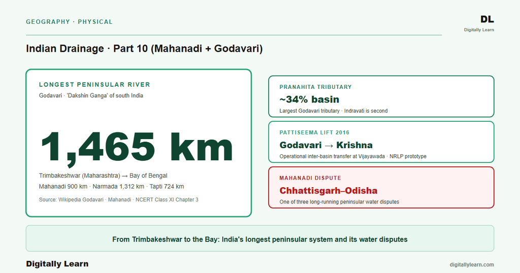
The Godavari rises at Brahmagiri Mountain near Trimbakeshwar in Nashik district of Maharashtra at an elevation of nine hundred and twenty metres per the Wikipedia Godavari article. The river runs one thousand four hundred and sixty-five kilometres from Brahmagiri to the Bay of Bengal at the Antarvedi delta, making it the second-longest river in India after the Ganga.
The Godavari basin covers approximately three hundred and twelve thousand eight hundred and twelve square kilometres across Maharashtra, Telangana, Andhra Pradesh, Chhattisgarh, Odisha, Karnataka, and Madhya Pradesh.
The river's course is broadly divisible into three reaches. The upper reach from Trimbakeshwar to Pochampad runs east-southeast across the Maharashtra plateau, picking up the Pravara from the right and the Purna from the left. The middle reach from Pochampad to Polavaram crosses the Telangana plateau and receives the Manjira and the Pranhita-system flows. The lower reach from Polavaram to the Antarvedi delta crosses the Andhra Pradesh coastal plain.
Trimbakeshwar is one of the twelve Jyotirlinga sites in Hindu cosmology, anchoring the Godavari's cultural significance alongside its hydrological one.
Why the Godavari Is Called the Dakshina Ganga
The Godavari is dubbed the Dakshina Ganga or Southern Ganges per the Wikipedia Godavari article. The nickname rests on three parallels with the Ganga of the north. The Godavari is the longest Peninsular river just as the Ganga is the longest Himalayan river within Indian territory. It carries comparable cultural and pilgrimage significance with the Kumbh Mela rotating to Nashik on the Godavari (covered in Part 8 of this series). It anchors the second-largest national basin after the Ganga itself.
The cultural parallel sustains the nickname even though the underlying hydrology of the two rivers is quite different.
Two major projects anchor the operational geography of the Godavari. The Sriram Sagar Project (also called Pochampad) sits in Nizamabad district of Telangana and is the principal upper-Godavari multi-purpose project. The Polavaram National Project sits in Eluru district of Andhra Pradesh at the head of the Godavari delta, approximately forty kilometres upstream of the historic Sir Arthur Cotton Barrage in Rajahmundry.
Polavaram is designed to irrigate about nine hundred and forty thousand hectares across eight districts of Andhra Pradesh per the Wikipedia Polavaram Project article, and to serve as the eastern node of the Godavari-Krishna inter-basin transfer discussed later in this article.
The Pranhita-Wardha-Wainganga-Penganga Complex and Other Tributaries
The Godavari tributary network accepts substantial streams on the left and right bank in nearly equal alternation across its course. The left-bank tributaries are the Purna, the Pranhita, the Indravati, and the Sabari. The right-bank tributaries are the Pravara, the Manjira, and the Manair. The largest tributary by drainage area is the Pranhita, which the Wikipedia Godavari article records as covering about thirty-four per cent of the entire Godavari basin. The Indravati is the second-largest tributary by drainage area.
The Pranhita is unusual in that it is itself a confluence river rather than a single stream. Per the Wikipedia Godavari article, the Pranhita is formed by the confluence of three Madhya Pradesh and Maharashtra rivers: the Wardha, the Wainganga, and the Penganga. The combined Pranhita then enters the Godavari near Kaleshwaram in Telangana. UPSC Prelims of 2015 confirmed that the Indravati and the Pranhita are Godavari tributaries while the Vamsadhara and the Pennar are independent east-flowing rivers.
The Manjira on the right bank is the longest Godavari tributary, running about seven hundred and twenty-four kilometres per the Wikipedia Godavari article. The Manjira drains southern Maharashtra and northern Telangana and carries the Singur reservoir that supplies drinking water to Hyderabad. The Sabari drains Bastar and Koraput in Chhattisgarh-Odisha and joins the Godavari near the Polavaram apex. The combined left-bank and right-bank tributary network gives the Godavari its dendritic geometry across the Deccan plateau.
Inter-State Tribunals, Polavaram, and the Contemporary Frame
GWDT 1980 and the Mahanadi Tribunal
The Godavari Water Disputes Tribunal, constituted under the Inter-State River Water Disputes Act of 1956, was set up in 1969 and delivered its final award in 1980. The tribunal allocated the Godavari's flow between Maharashtra, Madhya Pradesh, Andhra Pradesh, Karnataka, and Odisha. The 1980 award has been the operational basis for every subsequent project on the Godavari, including the Pochampad-Sriram Sagar reservoir and the Polavaram National Project.
The tribunal architecture remains the classic example of how the constitutional mechanism under Article 262 (covered in Part 9 of this series) is applied to a major Peninsular basin.
The Mahanadi Water Disputes Tribunal was constituted in 2018 to adjudicate the long-standing dispute between Chhattisgarh and Odisha over Mahanadi water sharing. The dispute centres on Chhattisgarh's upstream barrage construction and the consequent reduction of dry-season flows reaching the Hirakud command area downstream in Odisha. Unlike the Godavari case where the tribunal architecture has worked through to a final award, the Mahanadi tribunal is still hearing submissions at the time of writing.
The contrast highlights the persistent process inadequacy of the constitutional dispute-resolution mechanism flagged by the 2013 UPSC Mains question on inter-state water disputes.
Pattiseema, River Linking, and the Climate Frame
Contemporary linkages: Three forward-looking pressures shape Mahanadi-Godavari basin governance for the next decade. The Pattiseema Lift Irrigation Project, inaugurated in March 2016, transfers Godavari water to the Krishna near Vijayawada and is the operational core of the broader Godavari-Krishna river-linking proposal under the National River Linking Project. This transfer is the working prototype for inter-basin transfer in the Peninsular family and is the subject of the 2017 UPSC Mains question on river linking.
A second pressure is climate-driven monsoon variability, which the Peninsular family depends on entirely, because the dry-season buffer the Himalayan family enjoys does not exist here.
A third pressure is reservoir sedimentation: the Hirakud-Polavaram-Sriram Sagar trinity of large reservoirs faces a sediment-accumulation challenge that no Peninsular project anticipated at design time. As deposits accumulate behind these dams the effective storage shrinks, and the safety margins for monsoon-flood routing degrade. The Brahmaputra-style sediment management problem covered in Parts 5 and 9 of this series is now visible across the Peninsular reservoir network as well, despite the markedly lower per-unit-area sediment loads.
The next parts of this series turn to the Krishna and Kaveri (Part 11), the Peninsular west-flowing rivers plus inland Luni (Part 12), riverine landforms (Part 13), the economy and river-linking (Part 14), and the floods-pollution-conservation synthesis (Part 15).
Prelims MCQ practice
Each question below tests one specific concept on the topic. Click to reveal the answer and a full option-wise explanation.
Q1. Consider the following statements about the Mahanadi:
- The Mahanadi rises at Nagri-Sihawa in Dhamtari district of Chhattisgarh at an elevation of about eight hundred and ninety metres.
- The total length of the Mahanadi from source to mouth is about nine hundred kilometres.
- The Mahanadi reaches the Bay of Bengal through a multi-distributary delta downstream of Cuttack at Paradip.
Which of the statements given above are correct?
- 1 only
- 1 and 2 only
- 2 and 3 only
- 1, 2 and 3
Show answer and explanation
Answer: 1, 2 and 3
Explanation.
All three statements match the Wikipedia Mahanadi article: source at Nagri-Sihawa Dhamtari Chhattisgarh at 890 m, length 900 km, delta exit at Paradip downstream of Cuttack.
Q2. Consider the following statements about the Hirakud Dam:
- The Hirakud Dam was formally inaugurated by Prime Minister Jawaharlal Nehru on 13 January 1957.
- The total length of the dam including dykes is about twenty-five point eight kilometres.
- The Hirakud Dam is the longest major earthen dam in the world.
Which of the statements given above are correct?
- 1 only
- 1 and 2 only
- 2 and 3 only
- 1, 2 and 3
Show answer and explanation
Answer: 1, 2 and 3
Explanation.
All three statements match the Wikipedia Hirakud Dam article: 13 January 1957 inauguration by Nehru, 25.8 km total length including dykes, world's longest major earthen dam.
Q3. Consider the following statements about the Godavari:
- The Godavari rises at Brahmagiri Mountain near Trimbakeshwar in Nashik district of Maharashtra at an elevation of about nine hundred and twenty metres.
- At about one thousand four hundred and sixty-five kilometres, the Godavari is the second-longest river in India after the Ganga.
- The Godavari is dubbed the Dakshina Ganga or Southern Ganges.
Which of the statements given above are correct?
- 1 only
- 1 and 2 only
- 2 and 3 only
- 1, 2 and 3
Show answer and explanation
Answer: 1, 2 and 3
Explanation.
All three statements match the Wikipedia Godavari article: Brahmagiri Mountain Trimbakeshwar Nashik Maharashtra at 920 m, length 1,465 km second-longest after Ganga, Dakshina Ganga nickname.
Q4. Consider the following statements about Godavari tributaries:
- The Pranhita is the largest tributary of the Godavari and covers about thirty-four per cent of the basin.
- The Pranhita is itself formed by the confluence of the Wardha, the Wainganga, and the Penganga.
- The Vamsadhara is a left-bank tributary of the Godavari.
Which of the statements given above are correct?
- 1 only
- 1 and 2 only
- 2 and 3 only
- 1, 2 and 3
Show answer and explanation
Answer: 1 and 2 only
Explanation.
Statements 1 and 2 match the Wikipedia Godavari article. Statement 3 is incorrect: the Vamsadhara is an independent east-flowing river that drains directly to the Bay of Bengal, not a Godavari tributary, as confirmed by the 2015 UPSC Prelims.
Q5. Consider the following statements about the Polavaram Project and the Pattiseema Lift:
- The Polavaram Project is located in Eluru district of Andhra Pradesh and is designed to irrigate about nine hundred and forty thousand hectares.
- The Polavaram Project has been accorded National Project status by the Central Government.
- The Pattiseema Lift Irrigation Project transfers Godavari water to the Krishna and was commissioned in 2016.
Which of the statements given above are correct?
- 1 only
- 1 and 2 only
- 2 and 3 only
- 1, 2 and 3
Show answer and explanation
Answer: 1, 2 and 3
Explanation.
All three statements match the Wikipedia Polavaram Project article and the documented Pattiseema commissioning record: Eluru district AP location, 940,000 ha irrigation design, National Project status, and the 2016 Pattiseema Godavari-Krishna transfer commissioning.
Sources
- India Physical Environment, Class 11, Chapter 3: Drainage System
- Mahanadi
- Godavari River
- Hirakud Dam
- Polavaram Project
- Pranhita River
- Indravati River
- Mahanadi and Godavari basin reports
- Pattiseema Lift Irrigation Project and river-linking documents
- Polavaram environmental clearance and tribunal records
- Tectonic Atlas of India and Deccan plateau memoirs
- Mahanadi Water Disputes Tribunal and Polavaram National Project releases
Disclaimer
Numerical claims on the Mahanadi, the Godavari, the Hirakud Dam, and the Polavaram Project, covering river lengths, source elevations, basin areas, and project capacities, follow NCERT and the cited primary sources. For operational detail on the Polavaram National Project and the Pattiseema Lift, consult the Central Water Commission and the National Water Development Agency portals.


