
Overview
Previous Year UPSC-CSE Questions By the end you will be able to draft model answers for the following UPSC questions. Each question carries a collapsible framework showing how to approach it in the exam.
- Prelims 2008On which one of the following rivers is the Tehri Hydropower Complex located?
How to approach this Prelims question
Approach: Recall that the Tehri Dam is located at the confluence of the Bhagirathi and the Bhilangana in Uttarakhand. The reservoir is fed primarily by the Bhagirathi, the Hindu-traditional source stream of the Ganga (covered in Part 7).
Trap to watch: Alaknanda is the hydrological source stream of the Ganga (greater length and discharge) and is a common confusion. Dhauliganga is the Alaknanda tributary that meets it at Vishnuprayag. Mandakini meets the Alaknanda at Rudraprayag.
Key facts to recall:
- Tehri Dam: Bhagirathi river, Uttarakhand.
- Bhagirathi rises at Gangotri glacier (Gomukh) at 3,892 m.
- Alaknanda is the other Ganga headwater per Part 7.
- Tehri Hydropower Complex installed capacity 2,000 MW (1,000 MW main dam, 1,000 MW pumped-storage).
Answer signal: Bhagirathi (option b).
- Prelims 2015Consider the following statements:
- The Accelerated Irrigation Benefits Programme was launched during 1996-97 to provide loan assistance to poor farmers.
- The Command Area Development Programme was launched in 1974-75 for the development of water-use efficiency.
Which of the statements given above is/are correct?
How to approach this Prelims question
Approach: Statement 1 is FALSE: AIBP launched 1996-97 provides central GRANT assistance to STATES for completing major and medium irrigation PROJECTS, not loans to poor farmers. Statement 2 is TRUE: CADP launched 1974-75 for water-use efficiency development.
Trap to watch: Statement 1 sounds plausible because government schemes often involve loan assistance to farmers, but AIBP is specifically a project-completion grant to state governments, not direct loan support.
Key facts to recall:
- AIBP 1996-97: central grant assistance to states for major and medium irrigation completion.
- CADP 1974-75: water-use efficiency, canal lining, on-farm extension.
- Both administered by Ministry of Jal Shakti (post-2019).
Answer signal: Statement 2 only is correct (option b).
- Prelims 2008Which of the following pairs are correctly matched? Irrigation Project – State
- Damanganga : Gujarat
- Girna : Maharashtra
- Pamba : Kerala Select the correct answer using the code given below:
How to approach this Prelims question
Approach: Verify each pair. Damanganga is a west-flowing river that meets the Arabian Sea in Gujarat and feeds the Daman Ganga irrigation project (Statement 1 correct). Girna is a Tapti tributary in Maharashtra with the Girna irrigation project (Statement 2 correct). Pamba rises in the Western Ghats of Kerala and feeds the Pamba irrigation project in Kerala (Statement 3 correct). All three pairs are correctly matched.
Trap to watch: Damanganga is sometimes confused with Dharampur in Maharashtra; the river crosses both Gujarat and Maharashtra but the irrigation project is in Gujarat.
Key facts to recall:
- Damanganga: Gujarat (river crosses Maharashtra-Gujarat).
- Girna: Maharashtra (Tapti tributary).
- Pamba: Kerala (Western Ghats).
- All three pairs correctly matched.
Answer signal: All three pairs correctly matched (option d).
- UPSC Mains 2016 GS-IEnumerate the problems and prospects of inland water transport in India.
How to structure the answer in the exam
Introduction: Inland water transport in India operates under the National Waterways Act 2016, which consolidates the network into 111 National Waterways administered by the Inland Waterways Authority of India. Despite the policy framework the modal share remains small because of structural problems addressed below.
Conclusion: Inland water transport prospects rest on the 111-waterway National Waterways Act framework and the Jal Marg Vikas Project; realising the prospects requires addressing the structural problems through year-round dredging programmes, inter-modal terminal investment, and bilateral protocols with Bangladesh that unlock the Brahmaputra-Ganga international connectivity.
How Indian Drainage Drives Irrigation, Power, Navigation, and Governance
Four Operational Dimensions of Indian Drainage
The Indian drainage economy is the network of operational uses that the country's river system supports. Four parallel dimensions sustain almost the entire agricultural, energy, transport, and industrial output of the country.
Irrigation feeds the bulk of Indian agriculture through canal commands and groundwater recharge dependent on rivers. Hydropower generates renewable electricity through dams across the Himalayan and Peninsular basins. Inland navigation moves bulk cargo along the National Waterways. Drinking water and industrial supply sustain urban and rural settlement across the country.
The drainage economy is the foundation on which most other economic activity in India ultimately rests. Approximately seventy per cent of Indian agriculture is irrigated and depends on river-fed canal systems and groundwater recharged by rivers. Approximately twelve per cent of India's installed electricity capacity is hydropower drawn from rivers.
Inland waterways carry a small but growing share of bulk freight along the Ganga and the Brahmaputra. Drinking water from rivers and their groundwater reservoirs supports almost every Indian city. The drainage system is therefore not merely a physical-geography topic but the working backbone of the Indian republic.
Why Drainage Governance Is the Integration Lens
What is the significance of treating drainage as the integration lens for the Indian economy. The four dimensions interact through a single physical river network and through a single constitutional governance architecture. Article 262 of the Constitution plus the Inter-State River Water Disputes Act 1956 together establish the dispute-resolution backbone covered in Part 9 of this series.
The National Perspective Plan 1980 plus the National Waterways Act 2016 establish the inter-basin transfer and navigation backbone covered in Sections 3 and 4 of this article. The result is that no single decision in Indian drainage governance is isolated; every dam, canal, waterway, and tribunal verdict feeds back into every other dimension.
| Dimension | Share | Lead institution |
|---|---|---|
| Irrigation (canal, groundwater) | About 70% of agriculture | Ministry of Jal Shakti, CWC |
| Hydropower (installed capacity) | About 12% of total power | Central Electricity Authority |
| Inland navigation (National Waterways) | Small but rising freight share | Inland Waterways Authority of India |
| Drinking and industrial water | Most urban and rural supply | MoEFCC, state water-resource departments |
Irrigation, Agriculture, and Hydropower
How River Water Feeds Indian Agriculture
Irrigation is the largest single use of Indian river water. The net irrigated area of about seventy million hectares covers approximately fifty per cent of total cropped area; the remainder is rainfed. River-fed irrigation is divided between surface canal commands drawn directly from dams and barrages, and groundwater irrigation drawn from aquifers that the rivers recharge.
The major canal commands include the Bhakra-Nangal system on the Sutlej (Indus basin, Part 6), the Indira Gandhi Canal from the Sutlej-Beas to western Rajasthan, the Hirakud command on the Mahanadi (Part 10), the Sardar Sarovar Narmada Main Canal in Gujarat (Part 12), and the Nagarjuna Sagar command on the Krishna (Part 11).
Two programme-level instruments coordinate central financial assistance to states for irrigation. The Accelerated Irrigation Benefits Programme (AIBP) was launched in 1996-97 to provide central grant assistance to states for completing major and medium irrigation projects within the funding cycle. The Command Area Development Programme (CADP) was launched in 1974-75 for water-use efficiency through canal lining, field channels, and on-farm extension.
The 2015 UPSC Prelims tested both programmes together, confirming that the AIBP supports project completion (not loans to poor farmers, as a common misreading assumes) and that the CADP was launched in 1974-75.
Hydropower: Installed Capacity, Untapped Potential, and Tehri
Hydropower is the second-largest river-water use after irrigation and the largest renewable source of electricity in India. Installed hydropower capacity is approximately forty-six gigawatts, against an assessed potential of approximately one hundred and fifty gigawatts.
The under-utilisation reflects siting constraints in the Himalayan basins (landslide and earthquake risk), environmental constraints in the Peninsular basins (forest clearance), and inter-state water-sharing disputes covered in Section 5. The Himalayan basins hold the majority of the untapped potential, particularly in the Brahmaputra basin (Part 9).
The major hydropower projects illustrate the Himalayan-Peninsular split. The Tehri Hydropower Complex on the Bhagirathi in Uttarakhand is the largest single project; the 2008 UPSC Prelims tested precisely this Bhagirathi attribution. The Bhakra-Nangal complex on the Sutlej is the oldest major hydropower scheme.
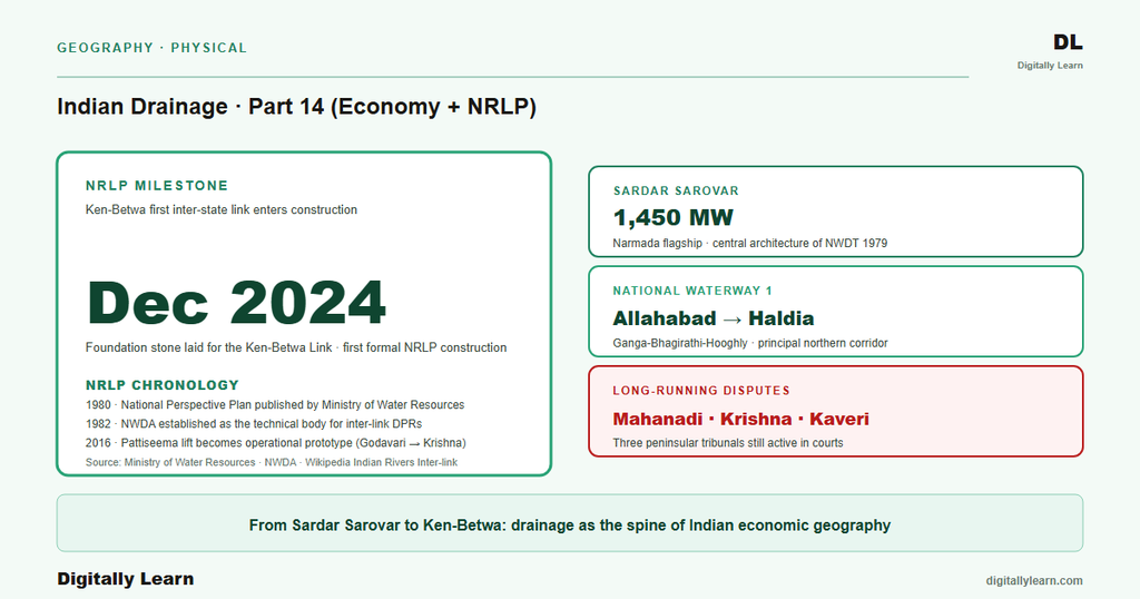
The Sardar Sarovar on the Narmada generates 1,450 MW (Part 12). The Nagarjuna Sagar and Srisailam projects on the Krishna (Part 11) represent the Peninsular hydropower picture. The National Hydroelectric Power Corporation is the lead public-sector developer for new Himalayan projects.
National Waterways and Inland Water Transport
The National Waterways Act 2016 and the One Hundred and Eleven Waterways
Inland navigation is the third operational dimension of the Indian drainage economy. The National Waterways Act 2016 consolidates and expands the Indian inland-waterway network. The Act declares one hundred and eleven National Waterways in total: the five waterways that were already declared under earlier separate Acts plus one hundred and six new waterways identified under the 2016 consolidation. The Inland Waterways Authority of India (IWAI) administers the network through dredging, navigation aids, and terminal infrastructure.
The five pre-existing National Waterways set the operational template for the rest. National Waterway 1 covers the Allahabad-Haldia stretch of the Ganga-Bhagirathi-Hooghly and is the principal navigable corridor for the northern Indian plain. National Waterway 2 covers the Sadiya-Dhubri stretch of the Brahmaputra in Assam (Part 9). National Waterway 3 covers the Kollam-Kottapuram stretch of the West Coast Canal and the Kerala backwaters.
National Waterway 4 covers the Krishna-Godavari delta channels (Parts 10 and 11). National Waterway 5 covers the Brahmani-Mahanadi delta channels in Odisha (Part 10). The 2016 Act added 106 additional waterways spanning every major Indian basin.
Problems and Prospects of Indian Inland Water Transport
Indian inland water transport faces structural problems despite the policy framework. Seasonal flow variability limits year-round navigability; the dry-season draft on the Ganga and the Brahmaputra falls below the minimum required for bulk cargo. Sediment management requires continuous dredging at locks and channel-control structures, which is expensive.
Inter-modal connectivity between river terminals and road or rail networks is patchy. Competition from highway and railway transport keeps inland-waterway freight share small. The 2016 UPSC Mains question on inland water transport tested precisely these problem-and-prospect dimensions.
The prospects rest on three forward-looking developments. The Jal Marg Vikas Project on NW-1 (Varanasi-Haldia) upgrades the multi-modal terminals at Varanasi, Sahibganj, and Haldia under World Bank co-financing. Brahmaputra navigation on NW-2 connects Assam to international shipping via the Indo-Bangladesh Protocol Route through Bangladeshi waters.
Tourism waterways on the Kerala backwaters (NW-3) and the Goan rivers (NW-68) leverage inland navigation for the tourism economy. The combined effect is a slow shift in Indian freight modal-share toward inland waterways from a historically negligible base.
The National River Linking Project: Thirty Inter-State Links
National Perspective Plan 1980 and the Thirty Inter-State Link Plan
The National Perspective Plan was published in 1980 by the Ministry of Water Resources and remains the governing document of the National River Linking Project. The plan envisages two principal components.
The Himalayan Rivers Development component covers fourteen inter-state links to transfer surplus Himalayan basin water (Brahmaputra, upper Ganga) to deficit basins in the Subarnarekha, the Mahanadi, and beyond. The Peninsular Rivers Development component covers sixteen inter-state links to transfer surplus Peninsular water (Mahanadi, Godavari) southward through the Krishna, the Pennar, and ultimately to the Cauvery, the Vaigai, and the Gundar.
The National Water Development Agency (NWDA) was established in 1982 as the technical body to study and prepare detailed project reports for each NRLP link. The agency has also studied thirty-seven intrastate links in addition to the thirty inter-state links of the National Perspective Plan. The NWDA portfolio therefore includes a total of about sixty-seven river-linking projects at various stages of feasibility study, detailed project report, and implementation.
Pattiseema 2016, Ken-Betwa 2024, and the Operational Pipeline
Two NRLP-relevant links have moved from feasibility study to working reality. The Pattiseema Lift Irrigation Project commissioned in 2016 (covered in Part 10) transfers Godavari water to the Krishna at Vijayawada and serves as the working prototype for the Peninsular component.
The Ken-Betwa Link Project foundation stone was laid on 25 December 2024, marking the first formal NRLP inter-state link to enter construction. The Ken-Betwa link transfers water from the Ken (Yamuna tributary) to the Betwa (Yamuna tributary) for the drought-prone Bundelkhand region of Madhya Pradesh and Uttar Pradesh.
Beyond these two, the Par-Tapi-Narmada Link covered in Part 12 of this series remains under feasibility study. The Mahanadi-Godavari Link, the Damanganga-Pinjal Link (Mumbai water supply), and the Polavaram-Vijayawada Link are at various stages of detailed project report.
The environmental critique of the broader NRLP rests on three concerns: ecological-flow disruption in source basins, submergence of forest and tribal habitat for canal alignment, and the carbon footprint of pumping infrastructure. The 2017 UPSC Mains question on river linking covered in Part 10 of this series tested these advantages-and-impacts dimensions directly.
Six Inter-State Tribunals: A Consolidated Architecture
Six Tribunals Across Six Decades of Indian Water Governance
The Indian water-disputes architecture rests on six tribunals constituted under Article 262 of the Constitution and the Inter-State River Water Disputes Act 1956 (covered in detail in Part 9). The earliest is the Godavari Water Disputes Tribunal constituted 1969 with final award 1980 (covered in Part 10). The Krishna Water Disputes Tribunal I (Bachawat) ran 1969 to 1973 and KWDT-II (Brijesh Kumar) ran 2004 to 2013 (Part 11).
The Cauvery Water Disputes Tribunal ran 1990 to 2007, with the Supreme Court's 16 February 2018 verdict and the Cauvery Water Management Authority formed in June 2018 (Part 11). The Vansadhara Water Disputes Tribunal was constituted in 2010 between Andhra Pradesh and Odisha. The Mahanadi Water Disputes Tribunal was constituted in 2018 between Chhattisgarh and Odisha (Part 10).
The consolidated picture is that the constitutional dispute-resolution mechanism has produced six tribunal awards across six decades, plus the 2018 Supreme Court Cauvery verdict that effectively modified the 2007 CWDT award. The 2013 and 2018 UPSC Mains questions on inter-state water disputes and tribunals (covered in Parts 9 and 11) test whether this architecture is fit for purpose.
The recurring critique is process inadequacy: tribunal proceedings take decades, awards are challenged in the Supreme Court, and inter-state political relations are degraded throughout. The reform proposal is a permanent inter-state water tribunal with binding awards and time-bound process, currently in legislative consideration.
Climate Stress, Tribunal Reform, and the Next Decade of Water Governance
Climate Change, Tribunal Reform, and the Future of Indian Drainage Governance
Three forward-looking pressures shape the next decade of Indian drainage-economy governance. First, climate change is shifting the precipitation regime that all four dimensions depend on. Intensifying monsoon-pulse variability raises peak floods (lower hydropower utilisation, raised dam-safety margins) and prolongs the dry season (irrigation deficits, navigation drafts below minima).
Second, the NRLP faces a credibility test: the Pattiseema lift of 2016 and the Ken-Betwa foundation of 25 December 2024 are working milestones, but the broader 30-link envelope of the National Perspective Plan 1980 has moved slowly and faces sustained environmental critique.
Third, tribunal reform is the most actively-debated governance question. The proposed Inter-State River Water Disputes (Amendment) Act would establish a permanent inter-state water tribunal to replace the case-by-case tribunal architecture that has produced multi-decade delays. The reform would also create a Dispute Resolution Committee for technical pre-tribunal screening, potentially shortening the average dispute lifecycle.
The reform's passage and implementation remain contingent on inter-state political agreement, which is itself constrained by the same dispute pressures the reform aims to resolve. Part 15 closes the series with the floods-pollution-conservation-climate synthesis.
Prelims MCQ practice
Each question below tests one specific concept on the topic. Click to reveal the answer and a full option-wise explanation.
Q1. Consider the following statements about Indian irrigation programmes:
- The Accelerated Irrigation Benefits Programme (AIBP) was launched in 1996-97 to provide central grant assistance to states for completing major and medium irrigation projects.
- The Command Area Development Programme (CADP) was launched in 1974-75 for the development of water-use efficiency through canal lining and on-farm extension.
- Both AIBP and CADP are administered by the Ministry of Agriculture rather than the Ministry of Jal Shakti.
Which of the statements given above are correct?
- 1 only
- 1 and 2 only
- 2 and 3 only
- 1, 2 and 3
Show answer and explanation
Answer: 1 and 2 only
Explanation.
Statements 1 and 2 match the established launch years and purposes of AIBP and CADP. Statement 3 is incorrect: both programmes are administered by the Ministry of Jal Shakti (created in 2019 from the earlier Ministry of Water Resources), not the Ministry of Agriculture.
Q2. Consider the following statements about Indian hydropower:
- The Tehri Hydropower Complex is located on the Bhagirathi river in Uttarakhand.
- India's installed hydropower capacity is approximately forty-six gigawatts against an assessed potential of about one hundred and fifty gigawatts.
- The National Hydroelectric Power Corporation is the lead public-sector developer for new Himalayan hydropower projects.
Which of the statements given above are correct?
- 1 only
- 1 and 2 only
- 2 and 3 only
- 1, 2 and 3
Show answer and explanation
Answer: 1, 2 and 3
Explanation.
All three statements match the Tehri Dam record and Central Electricity Authority data: Tehri on Bhagirathi, ~46 GW installed vs ~150 GW potential, NHPC as the Himalayan-projects developer.
Q3. Consider the following statements about the National Waterways:
- The National Waterways Act 2016 declared 111 National Waterways in total, including 5 pre-existing and 106 new.
- National Waterway 1 covers the Allahabad-Haldia stretch of the Ganga-Bhagirathi-Hooghly.
- The Inland Waterways Authority of India administers the network.
Which of the statements given above are correct?
- 1 only
- 1 and 2 only
- 2 and 3 only
- 1, 2 and 3
Show answer and explanation
Answer: 1, 2 and 3
Explanation.
All three statements match the National Waterways Act 2016 record: 111 NWs total (5 plus 106), NW-1 Allahabad-Haldia Ganga-Bhagirathi-Hooghly, IWAI as administering authority.
Q4. Consider the following statements about the National River Linking Project (NRLP):
- The National Perspective Plan for the NRLP was adopted in 1980 by the Ministry of Water Resources.
- The NRLP comprises 14 Himalayan-component links plus 16 Peninsular-component links plus 37 intrastate links per NWDA studies.
- The Pattiseema Lift Irrigation Project commissioned in 2016 transfers Krishna water to the Godavari.
Which of the statements given above are correct?
- 1 only
- 1 and 2 only
- 2 and 3 only
- 1, 2 and 3
Show answer and explanation
Answer: 1 and 2 only
Explanation.
Statements 1 and 2 match the Indian Rivers Inter-link record: NPP 1980, 14 plus 16 inter-state plus 37 intrastate links. Statement 3 is incorrect: Pattiseema transfers Godavari water to the Krishna, not Krishna to Godavari.
Q5. Consider the following statements about the Indian inter-state water disputes architecture:
- Article 262 of the Constitution and the Inter-State River Water Disputes Act 1956 establish the dispute-resolution backbone.
- The Krishna Water Disputes Tribunal II (Brijesh Kumar) delivered its final award on 29 November 2013.
- The Cauvery Water Management Authority was formed in June 2018 following the Supreme Court verdict of 16 February 2018.
Which of the statements given above are correct?
- 1 only
- 1 and 2 only
- 2 and 3 only
- 1, 2 and 3
Show answer and explanation
Answer: 1, 2 and 3
Explanation.
All three statements are consistent with Parts 9 and 11 of this series and the Wikipedia Krishna Water Disputes Tribunal and Kaveri River articles.
Sources
- India Physical Environment, Class 11, Chapter 3: Drainage System
- Indian Rivers Inter-link
- National Waterways Act, 2016
- Tehri Dam
- Krishna Water Disputes Tribunal
- Inland Waterways Authority of India
- Annual basin reports and irrigation potential utilisation
- National Perspective Plan and link-project DPRs
- Environmental clearance for river-linking projects
- Indus Waters Treaty and Ganga Waters Treaty records
- Ken-Betwa Link foundation and Pattiseema commissioning releases
- Tectonic Atlas of India
Disclaimer
Figures for hydropower capacity, the NRLP link count, the National Waterway count, and tribunal award years are drawn from the primary sources listed above. River-linking projects such as Ken-Betwa are evolving, so readers should confirm current status with the National Water Development Agency.


