
Overview
Previous Year UPSC-CSE Questions By the end you will be able to draft model answers for the following UPSC questions. Each question carries a collapsible framework showing how to approach it in the exam.
- Prelims 1997The canal carrying capacity of Farakka is
How to approach this Prelims question
Approach: Recall the standard canal-capacity figure of 40,000 cusecs for the Farakka feeder canal. The design discharge of 1,800 cubic metres per second converts to approximately 63,600 cusecs at maximum, but the UPSC-accepted carrying capacity for the canal as cited in standard Indian Government references is 40,000 cusecs.
Trap to watch: The conversion between cubic metres per second and cusecs can yield different numerical answers depending on whether design capacity or actual carrying capacity is being asked.
Key facts to recall:
- Farakka Barrage commissioned 21 April 1975 in Murshidabad district, West Bengal.
- Eighteen kilometres from the Bangladesh border.
- Feeder canal forty-two kilometres long.
- Design capacity 1,800 cubic metres per second.
- UPSC-accepted canal carrying capacity 40,000 cusecs.
Answer signal: Forty thousand cusecs (option c).
- Prelims 2011The 2004 Tsunami made people realize that mangroves can serve as a reliable safety hedge against coastal calamities. How do mangroves function as a safety hedge?
How to approach this Prelims question
Approach: Recall the established answer: mangrove root architecture (aerial roots, pneumatophores, stilt roots) anchors the trees in soft tidal mud and prevents uprooting under storm surge or tsunami wave action. The standing forest then breaks the wave energy. Options A, B, and C describe collateral or incorrect functions.
Trap to watch: Option C (tall trees with dense canopies) sounds plausible but mangroves are short and shrubby; their protective function rests on roots not canopy.
Key facts to recall:
- Mangrove aerial root systems anchor trees in soft mud.
- Standing forest dissipates wave energy.
- Sundarbans served this function during the 2004 Indian Ocean tsunami.
- Continuing protection during Aila (2009), Bulbul (2019), Amphan (2020) cyclones.
Answer signal: Mangrove trees do not get uprooted by storms and tides because of their extensive roots (option d).
- UPSC Mains 2019 GS-IDiscuss the causes of depletion of mangroves and explain their importance in maintaining coastal ecology.
How to structure the answer in the exam
Introduction: The Sundarbans at the Ganges-Brahmaputra-Meghna delta is the world's largest mangrove forest at 10,277 square kilometres, hosts about 180 Royal Bengal Tigers, and serves as the classic example of the ecological functions and human pressures discussed below.
Conclusion: Mangrove conservation requires integration of coastal-zone regulation, upstream sediment management through dam-operation reform, and sea-level adaptation; isolated reserve creation alone cannot reverse the cumulative pressure from upstream and seaward simultaneously.
How the Ganga Changes Personality Once It Enters the Plain
The Lower Ganga as a Plain-Reach River
The lower Ganga is the reach of the river between its emergence onto the Indo-Gangetic plain below Haridwar and the Ganga delta at the Bay of Bengal. This plain-reach Ganga is hydrologically and culturally distinct from the headwater system covered in Part 7.
Below Haridwar the river enters the Indo-Gangetic alluvial plain, drops nearly all of its gradient, and switches from vertical incision to lateral migration. Its geomorphic vocabulary becomes meandering, oxbow formation, and floodplain reworking; its cultural vocabulary becomes pilgrimage, ghats, and Kumbh.
Why it matters: The lower Ganga supports the densest concentration of population on the Indian subcontinent. The Ganga delta alone carries about two hundred and seventy-three million people on its surface, split roughly two-thirds in Bangladesh and one-third in West Bengal.
The pilgrimage geography from Gangotri to Ganga Sagar traces the Hindu sacred map, while the delta supports the Royal Bengal Tiger and the world's largest mangrove forest. The reach is therefore where physical geography, cultural geography, and ecology become inseparable.
Why the Plain-Reach Ganga Is Treated as a Single Topic
What is the significance of the lower Ganga reach: Four distinct phenomena unfold along the same physical river. First, the channel geomorphology shifts from the Bhabhar-Terai-Bhangar-Khadar sequence covered in Part 5 to large-scale meandering and oxbow formation. Second, the Farakka Barrage and the Hooghly-Padma distributary architecture together govern the division of flow between Indian and Bangladeshi territory.
Third, the Ganges-Brahmaputra-Meghna delta is the world's largest river delta and the floor of one of the most populous and most climate-vulnerable regions on the planet. Fourth, the Hindu sacred geography from Gangotri to Ganga Sagar follows this same physical river and gives it cultural-spiritual weight no other Indian river carries.
| Attribute | Value | Source |
|---|---|---|
| Delta total area | About 105,000 km² | Wikipedia Ganges Delta |
| Delta status | World's largest river delta | Wikipedia Ganges Delta |
| Delta population | About 273.6 million (173.6 Bangladesh and 100 India) | Wikipedia Ganges Delta |
| Sundarbans total area | 10,277 km² (6,017 Bangladesh and 4,260 India) | Wikipedia Sundarbans |
| Sundarbans UNESCO designation | India 1987 and Bangladesh 1997 | Wikipedia Sundarbans |
| Sundarbans Bengal Tigers | About 180 (106 Bangladesh and 74 India) | Wikipedia Sundarbans (2011-15 census) |
| Farakka Barrage | Commissioned 21 April 1975, 18 km from Bangladesh border | Wikipedia Farakka Barrage |
| Indo-Bangladesh Ganges Water Treaty | Signed 12 December 1996; 30-year term to 2026 | Wikipedia Ganges Water Sharing Treaty |
Channel Geomorphology of the Ganga in the Indo-Gangetic Plain
Why the Ganga Meanders and How Oxbow Lakes Form
The Ganga in its plain reach is the textbook example of a meandering river. Three structural conditions sustain the meandering pattern. Low gradient across the Indo-Gangetic plain (under twenty centimetres per kilometre on average) gives the river time to swing laterally across its floodplain.
Cohesive silt-clay banks from the upstream sediment supply (covered in Part 5) hold the channel together long enough for sinuosity to develop. Heavy suspended sediment load from the Himalayan front gives the river the deposition partner that maintains the meander geometry.
A meandering river behaves asymmetrically at every bend. The inner bank moves slowly and accumulates a wedge of sand and silt called a point bar. The outer bank moves fast and erodes back, producing a cut bank.
Over time the meander loop tightens; when the neck of the loop narrows enough that a flood can breach it, the river abandons the loop and takes the shorter path. The abandoned arc fills with water and becomes an oxbow lake. The Kanwar Lake in Bihar, formed by the Burhi Gandak meandering, is the standard Indian example.
Natural Levees, Crevasse Splays, and the Bhangar-Khadar Sequence
Beyond the meander geometry, the Ganga in its plain reach builds three additional floodplain features. Natural levees rise on both banks during overbank flow when the flooded river drops its coarsest sediment immediately adjacent to the channel. Over centuries these levees can elevate the river bed above the surrounding plain, a condition documented on the lower Hooghly.
Crevasse splays form when a flood breaches a levee and deposits a fan of sediment on the floodplain beyond. Avulsions, the wholesale abandonment of an old channel for a new one, are the largest expression of the same process and were treated in Part 4 of this series for the Kosi 2008 avulsion.
The lateral arrangement of the floodplain follows the four belts of Part 5: Bhabhar at the Himalayan front (porous gravel), Terai south of it (re-emerging streams), Bhangar further south (older alluvium terraces above the active floods), and Khadar along the present channel (younger active alluvium reworked every monsoon).
On the Ganga main stem the Bhangar belt carries most of the agricultural Uttar Pradesh and Bihar landscape, while the Khadar belt accepts the annual flood pulse. The two belts together carry the densest agricultural population on the planet.
Farakka Barrage and the Hooghly-Padma Distributary Architecture
Why Farakka Was Built and What It Does
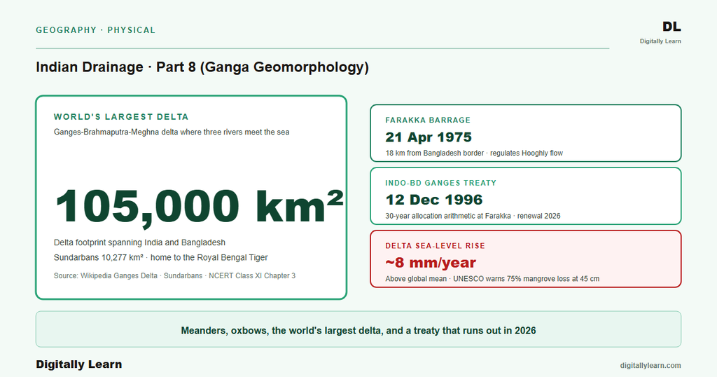
The Farakka Barrage became operational on 21 April 1975 at a site roughly eighteen kilometres from the Bangladesh border in Murshidabad district, West Bengal. Its purpose was to address a slow-motion crisis on the Hooghly River, the western distributary of the Ganga that carries water from the main stem down to Kolkata.
By the mid-twentieth century the Hooghly had silted up sufficiently that Kolkata Port was struggling to remain navigable. Farakka's design diverted a controlled portion of the Ganga's main flow into a feeder canal that delivered water into the Bhagirathi-Hooghly system upstream of the silting reach.
The feeder canal from Farakka to the Bhagirathi-Hooghly River is about forty-two kilometres long with a design diversion of about one thousand eight hundred cubic metres per second. The UPSC Prelims paper of 1997 tested the canal's carrying capacity in cusecs, recording the official answer at forty thousand cusecs.
The barrage itself is the upstream control structure that decides how much of the Ganga's flow heads west to the Hooghly and how much continues east as the Padma into Bangladesh. The 1996 Indo-Bangladesh Ganges Water Treaty discussed below governs the allocation between the two.
The Hooghly and the Padma: Two Different Trajectories for the Same River
Below Farakka the Ganga splits into two distributaries with very different downstream stories. The Hooghly runs south-west through West Bengal, picks up the Damodar and other right-bank tributaries on the way, and reaches the Bay of Bengal at Sagar Island, passing through Kolkata Port on the journey.
The Hooghly is the smaller of the two distributaries by volume, but it carries the entire Indian portion of the Ganga's lower discharge and the bulk of the cultural-economic weight of the Indian delta.
The Padma is the eastern distributary and the principal continuation of the Ganga proper. It enters Bangladesh, merges with the Brahmaputra (locally called Jamuna in Bangladesh) and the Meghna in succession, and reaches the Bay of Bengal through the world's largest delta. The Padma carries the majority of the combined Ganges-Brahmaputra-Meghna discharge by volume.
The Indo-Bangladesh Ganges Water Treaty of 12 December 1996, signed by Indian Prime Minister H. D. Deve Gowda and Bangladeshi Prime Minister Sheikh Hasina, governs the allocation between Hooghly diversion (India) and Padma continuation (Bangladesh) at Farakka. The treaty has a thirty-year term and expires in 2026.
The Ganges-Brahmaputra-Meghna Delta as the World's Largest
How a 105,000 Square Kilometre Delta Is Built and What Lives on It
The Ganges-Brahmaputra-Meghna delta covers about one hundred and five thousand square kilometres and is the world's largest river delta. About sixty-seven per cent of the delta lies in Bangladesh and thirty-three per cent in West Bengal, India.
The delta supports about two hundred and seventy-three million people, with roughly one hundred and seventy-three million in Bangladesh and one hundred million in West Bengal. It has prograded approximately four hundred kilometres seaward since the Eocene through the cumulative sediment supply of the Himalayan collision.
The delta is built by a complex of distributaries that fan out below the apex near Farakka. The major named distributaries are the Hooghly in the west (Indian side), the Padma in the centre (which receives the Brahmaputra and the Meghna), and the Gorai-Madhumati system on the Bangladeshi flank.
Each distributary builds its own sub-delta as it deposits sediment on the shallow continental shelf. The seaward edge is constantly reshaped by tidal currents from the Bay of Bengal.
The Sediment Conveyor That Sustains the Delta and the Population
The delta is sustained by the sediment conveyor covered in Part 5 of this series. The combined Ganges-Brahmaputra-Meghna system delivers about one billion tonnes of suspended sediment a year, with estimates ranging up to roughly two billion, the world's highest combined yield. Without this supply the delta would erode under tidal action and sea-level rise faster than it could rebuild.
Upstream dam construction, in particular hydropower projects on the Bhagirathi and the Brahmaputra, traps a growing fraction of the sediment behind reservoirs and reduces delivery to the delta. This sediment-starvation effect is now visible at the seaward margin and is one of the main drivers of the climate-vulnerability scenarios covered in Section 5.
The Sundarbans Mangrove Forest at the Mouth of the Ganga
What Makes the Sundarbans the Last Redoubt of the Royal Bengal Tiger
The Sundarbans is the world's largest mangrove forest, covering a total of ten thousand two hundred and seventy-seven square kilometres across the Ganga delta in two countries. The Bangladesh portion in Khulna Division covers about six thousand seventeen square kilometres; the Indian portion in West Bengal covers about four thousand two hundred and sixty square kilometres.
The forest is a UNESCO World Heritage Site (India 1987, Bangladesh 1997) and a Ramsar Wetland of International Importance (1992 and 2019). It is the last redoubt of the Royal Bengal Tiger, with about one hundred and eighty tigers in total, recorded as one hundred and six in Bangladesh and seventy-four in India in the 2011 and 2015 censuses.
The Sundarbans is a tidal mangrove ecosystem. Twice-daily tidal surges from the Bay of Bengal bring brackish water into a complex of channels and islands. The dominant species is Heritiera fomes (Sundari), which makes up about seventy per cent of the trees and gives the forest its name; Excoecaria agallocha and Avicennia species fill the rest.
The aerial root architecture of the mangroves binds the tidal mud against the very forces that deliver the salinity. The 2011 UPSC Prelims tested precisely this point, recognising that mangrove trees resist storm uprooting because of their extensive root systems.
Sea-Level Rise, Cyclones, and the Tiger Habitat at Risk
The Sundarbans now sit at the front line of climate vulnerability in the Bay of Bengal. Sea level at the delta margin was rising at about eight millimetres per year as of the 2010 measurement, a rate well above the global mean. A UNESCO assessment estimated that a forty-five centimetre rise in sea level could destroy up to seventy-five per cent of the mangroves by the end of the twenty-first century.
The combined effect of sea-level rise, dam-driven sediment starvation upstream, and intensifying cyclones is squeezing the mangrove zone from several directions at once. The forest is being compressed from the south by the sea and from the north by human settlement.
The mangrove zone served as a real-world tsunami buffer during the 2004 Indian Ocean tsunami. The ecological mechanism rests on the extensive root architecture of mangroves, which prevents storm uprooting so the trees remain standing and break the storm surge.
The Sundarbans mangrove zone provides the same cyclone-buffering function for the densely populated West Bengal coast against major Bay of Bengal storms such as Aila (2009), Bulbul (2019), and Amphan (2020).
Pilgrimage Spine, Kumbh Mela, and the 2026 Treaty Renewal
The Sacred Geography From Gangotri to Ganga Sagar
The Ganga's pilgrimage spine runs along the same physical river covered in Sections 1 through 5 and links five major cities. Gangotri at the head of the Bhagirathi marks the symbolic source. Haridwar at the foot of the Siwaliks is the first major pilgrimage city on the plain. Prayagraj hosts the Triveni Sangam confluence of the Ganga, the Yamuna, and the mythological Saraswati.
Varanasi on the middle Ganga is the most-revered pilgrimage city in Hinduism. Ganga Sagar at Sagar Island in the Hooghly delta is the southernmost pilgrimage site, where the river meets the Bay of Bengal.
The Kumbh Mela rotates through four sites on a twelve-year cycle. Prayagraj hosts the Kumbh on the Sangam every twelve years; the half-cycle Ardh Kumbh runs every six years. Haridwar hosts the Kumbh every twelve years on a different cycle. Nashik on the Godavari and Ujjain on the Shipra make up the four-site rotation.
Two of the four Kumbh sites are on the Ganga main stem, reflecting the river's centrality to the festival cycle. The Maha Kumbh at Prayagraj is the largest peaceful gathering of humans on the planet by attendance count.
The 1996 Treaty, the 2026 Renewal, and the Climate Frame
Contemporary linkages: Three live pressures define the next decade of Ganga-system governance. First, the Indo-Bangladesh Ganges Water Treaty, signed in New Delhi on 12 December 1996 by Indian PM H. D. Deve Gowda and Bangladeshi PM Sheikh Hasina, has a thirty-year term and expires in 2026. The renewal will need to absorb climate-driven shifts in the Ganga's dry-season flow that the 1996 arithmetic did not anticipate.
Second, the sediment-starvation problem documented in Section 4 makes the delta increasingly vulnerable to sea-level rise. Third, the Sundarbans tiger habitat is shrinking from the south through sea-level rise and from the north through human encroachment. Each pressure interacts with the other two.
The combined effect is that the Ganga system, like the Indus system covered in Part 6, is entering a period of structural reconfiguration. The next part of this series turns to the Brahmaputra and Northeast Indian drainage, where similar pressures play out on a different geography.
Part 9 will treat the Tsangpo Great Bend, the Assam braided floodplain, and the trans-boundary dialogue with China and Bangladesh that the Brahmaputra system requires. The cumulative picture across Parts 6 to 9 is that India's three great Himalayan basins are at once the foundation of its agricultural and cultural geography and its most climate-exposed water resources.
Prelims MCQ practice
Each question below tests one specific concept on the topic. Click to reveal the answer and a full option-wise explanation.
Q1. Consider the following statements about the Ganges-Brahmaputra-Meghna delta:
- The combined delta covers about one hundred and five thousand square kilometres and is the world's largest river delta.
- About ninety per cent of the delta lies within Indian territory in West Bengal.
- The delta has prograded seaward by about four hundred kilometres since the Eocene through the cumulative sediment supply of the Himalayan collision.
Which of the statements given above are correct?
- 1 and 2 only
- 1 and 3 only
- 2 and 3 only
- 1, 2 and 3
Show answer and explanation
Answer: 1 and 3 only
Explanation.
Statement 1 is correct: the delta covers about 105,000 square kilometres and is the world's largest river delta. Statement 3 is correct: progradation of about 400 kilometres since the Eocene. Statement 2 inverts the split: about 67 per cent of the delta lies in Bangladesh and only 33 per cent in West Bengal, India, not ninety per cent in India.
Q2. Consider the following statements about the Sundarbans:
- The Sundarbans cover a combined area of about ten thousand two hundred and seventy-seven square kilometres in India and Bangladesh.
- The Indian portion of the Sundarbans is approximately four thousand two hundred and sixty square kilometres in West Bengal.
- The total Royal Bengal Tiger population across both countries is about one hundred and eighty in the most-recent censuses.
Which of the statements given above are correct?
- 1 only
- 1 and 2 only
- 2 and 3 only
- 1, 2 and 3
Show answer and explanation
Answer: 1, 2 and 3
Explanation.
All three statements are correct: total area 10,277 square kilometres, the Indian portion about 4,260 square kilometres (Bangladesh about 6,017), and about 180 Royal Bengal Tigers in total (106 in Bangladesh in the 2015 census and 74 in India in the 2011 count).
Q3. Consider the following statements about the Farakka Barrage:
- The Farakka Barrage became operational in 1985 in Nadia district, West Bengal.
- The barrage sits about eighteen kilometres from the Bangladesh border.
- The feeder canal from the barrage to the Bhagirathi-Hooghly River is about forty-two kilometres long and diverts a design flow of about one thousand eight hundred cubic metres per second.
Which of the statements given above are correct?
- 1 only
- 1 and 2 only
- 2 and 3 only
- 1, 2 and 3
Show answer and explanation
Answer: 2 and 3 only
Explanation.
Statement 2 is correct: about 18 kilometres from the Bangladesh border. Statement 3 is correct: feeder canal about 42 kilometres long, design diversion about 1,800 cubic metres per second. Statement 1 is wrong on both counts: the barrage became operational on 21 April 1975, not 1985, and it is in Murshidabad district, not Nadia.
Q4. Consider the following statements about the Indo-Bangladesh Ganges Water Treaty:
- The treaty was signed on 12 December 1996 in New Delhi by Indian PM H. D. Deve Gowda and Bangladeshi PM Sheikh Hasina.
- The treaty governs the dry-season water-sharing arrangement at the Farakka Barrage.
- The treaty is a permanent arrangement with no fixed expiry date.
Which of the statements given above are correct?
- 1 and 2 only
- 1 and 3 only
- 2 and 3 only
- 1, 2 and 3
Show answer and explanation
Answer: 1 and 2 only
Explanation.
Statement 1 is correct: signed on 12 December 1996 in New Delhi by Deve Gowda and Sheikh Hasina. Statement 2 is correct: the treaty governs the Farakka dry-season allocation. Statement 3 is wrong: the treaty has a fixed thirty-year term and is due to expire in 2026, so it is not permanent.
Q5. Consider the following statements about the protective function of mangroves on the Sundarbans coast:
- Mangrove trees resist storm uprooting because of their extensive aerial root systems.
- The Sundarbans mangrove zone served as a buffer during the 2004 Indian Ocean tsunami.
- Mangroves protect the coast mainly because they are tall trees with dense canopies that block storm surges.
Which of the statements given above are correct?
- 1 and 2 only
- 1 and 3 only
- 2 and 3 only
- 1, 2 and 3
Show answer and explanation
Answer: 1 and 2 only
Explanation.
Statement 1 is correct, and matches the UPSC 2011 Prelims marking: mangroves resist uprooting because of their extensive roots. Statement 2 is correct: the Sundarbans buffered the 2004 Indian Ocean tsunami. Statement 3 is wrong: mangroves are short and shrubby; the protective function rests on the root architecture, not on tall dense canopies.
Sources
- India Physical Environment, Class 11, Chapter 3: Drainage System
- Ganges Delta
- Sundarbans
- Farakka Barrage
- Hooghly River
- Padma River
- Ganges water dispute and the 1996 Water Sharing Treaty
- Sundarban Wetland (India) and Sundarbans Reserved Forest (Bangladesh) Ramsar listings
- Namami Gange programme reach to Sundarbans
- Lower Ganga basin reports
- Sundarbans Tiger Reserve and biosphere reserve documents
- Indo-Bangladesh Ganges Water Treaty 1996 records
Disclaimer
Delta and Sundarbans areas, tiger counts, and treaty terms can be revised by their issuing agencies. Readers should confirm current figures and policy details against the official sources listed below before relying on them in an answer.


