


Overview
Origin, tributaries, the Yamuna and the Ganga basin
The Ganga river rises as the Bhagirathi in the Gangotri glacier in Uttarakhand and takes the name Ganga at Devprayag, where the Alaknanda joins it. It flows 2,525 km across the northern plains to the Bay of Bengal. With tributaries such as the Yamuna, Ghaghara, Gandak, Kosi and Son, it forms the largest river system in India, draining about a quarter of the country.
Ganga River: Origin, Length and Course
Ganga River Origin: Gangotri Glacier, Bhagirathi and Alaknanda
The Ganga river rises in the Gangotri glacier near Gaumukh (3,900 m) in the Uttarkashi district of Uttarakhand. Here it is called the Bhagirathi, and it cuts through the Central and the Lesser Himalayas in narrow gorges. At Devprayag the Bhagirathi meets the Alaknanda, and from there the river is known as the Ganga.
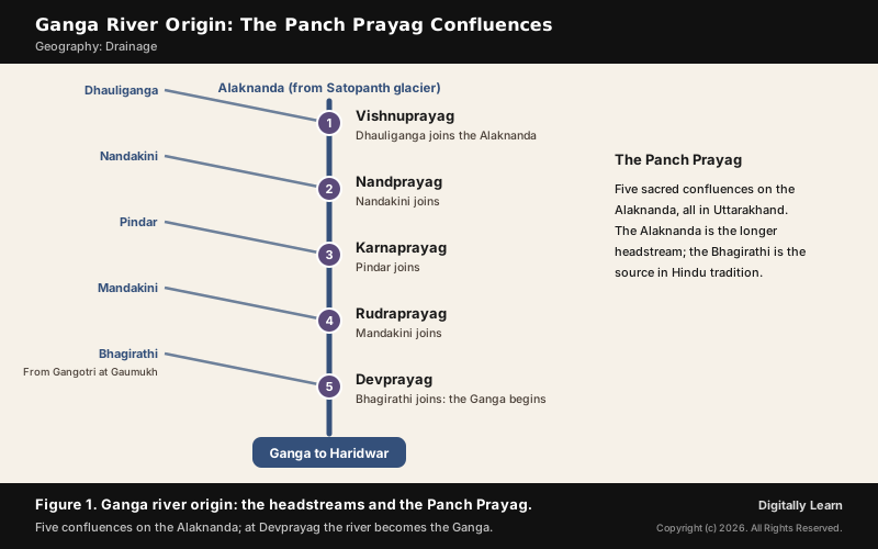
The Alaknanda rises in the Satopanth glacier above Badrinath. Being longer, it is the source stream in hydrology, while the Bhagirathi is the source in Hindu tradition. On its way down the Alaknanda passes five sacred confluences, the Panch Prayag:
- Vishnuprayag: The Dhauli and the Vishnu Ganga meet at Joshimath to form the Alaknanda.
- Nandprayag: The Nandakini joins the Alaknanda.
- Karnaprayag: The Pindar joins.
- Rudraprayag: The Mandakini, or Kali Ganga, joins.
- Devprayag: The Bhagirathi joins, and the river takes the name Ganga.
Ganga River Length and Course: Which States It Flows Through
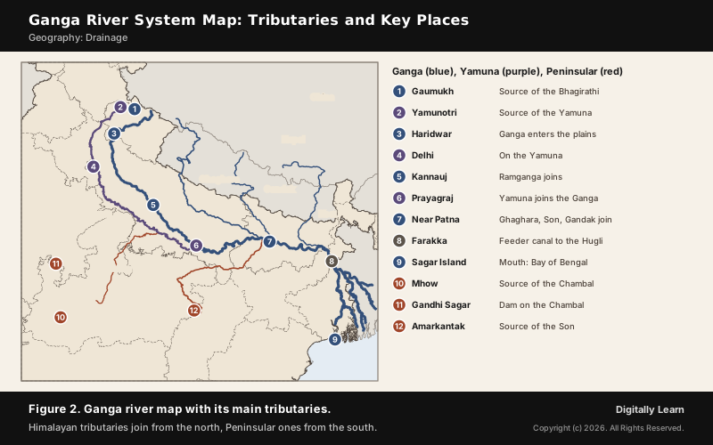
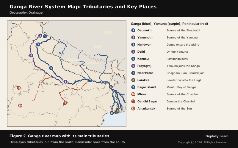
The Ganga enters the plains at Haridwar. From here it flows first to the south, then to the south-east and east, before splitting into two distributaries, the Bhagirathi and the Hugli. The river is 2,525 km long and finally discharges into the Bay of Bengal near Sagar Island.
| State | Length of the Ganga |
|---|---|
| Uttarakhand | 110 km |
| Uttar Pradesh | 1,450 km |
| Bihar | 445 km |
| West Bengal | 520 km |
- Farakka: In West Bengal a feeder canal from the Farakka Barrage diverts about half the Ganga’s flow southwards into the Hugli.
- In Bangladesh: The river is called the Padma. It is joined by the Jamuna, the lower stream of the Brahmaputra, and then by the Meghna before reaching the sea.
- Discharge: The Ganga-Brahmaputra-Meghna system is the second-largest river system on earth by discharge.
- History: Capitals such as Pataliputra, Kannauj and Kashi stood on the Ganga or its tributaries.
How the river builds meanders, oxbow lakes and its great delta is covered in Ganga Delta and Sundarbans, and the character of the Himalayan rivers in Himalayan River System.
Tributaries of Ganga River: Left Bank and Right Bank
Ganga River System: India's Largest River System
The Ganga river system is the largest in India. It gathers perennial rivers from the Himalayas in the north and non-perennial rivers from the Peninsula in the south, and its basin covers about 8.6 lakh square km in India alone. The Son is its major right bank tributary; the important left bank tributaries are the Ramganga, the Gomati, the Ghaghara, the Gandak, the Kosi and the Mahananda.
| Bank | Tributaries of Ganga |
|---|---|
| Left bank, from the Himalayas | Ramganga, Gomati, Ghaghara, Gandak, Kosi, Mahananda |
| Right bank | Yamuna, Son; the Damodar joins the Hugli |
Left Bank Tributaries of Ganga: Ramganga, Gomati, Ghaghara, Gandak and Kosi
The left bank tributaries rise in the Himalayas, several of them in Nepal, and most of them are perennial; they bring heavy loads of sediment onto the plains. From west to east:
- Ramganga: A comparatively small river rising in the Garhwal hills near Gairsain. It turns south-west after crossing the Shiwaliks, runs through the Patli Dun valley of Jim Corbett National Park, enters the plains near Najibabad and joins the Ganga near Kannauj.
- Gomati: Rises at the Gomat Taal in Pilibhit district and is fed by monsoon rain and groundwater, not snow; it flows through Lucknow and Jaunpur.
- Ghaghara: Rises in the glaciers of Mapchachungo, collects the Tila, Seti and Beri, and cuts a deep gorge at Shishapani. The Sarda joins it on the plain, and it meets the Ganga at Chhapra.
- Sarda: Rises in the Milan glacier, where it is called the Goriganga; along the India-Nepal border it is the Kali or Chauk, and it joins the Ghaghara.
- Gandak: Formed by the Kaligandak and the Trishulganga, it rises in the Nepal Himalayas between Dhaulagiri and Mount Everest, enters the plain in Champaran district of Bihar and joins the Ganga at Sonpur near Patna.
- Kosi: An antecedent river whose main stream, the Arun, rises north of Mount Everest in Tibet. In Nepal the Son Kosi from the west and the Tamur Kosi from the east join it to form the Sapt Kosi, which meets the Ganga near Kursela in Katihar district.
- Mahananda: Rises in the Darjeeling hills and joins the Ganga as its last left bank tributary, in West Bengal.
Right Bank Tributaries of Ganga: Son and Damodar
Apart from the Yamuna, the right bank tributaries come from the Peninsular plateau. They are non-perennial rivers, and they carry the drainage of the Vindhyas and the Chotanagpur Plateau to the Ganga.
- Son: A large south bank tributary rising on the Amarkantak plateau. It forms a series of waterfalls at the plateau edge and joins the Ganga west of Patna, near Arrah. It is 784 km long, the second-largest southern tributary after the Yamuna; its chief tributaries are the Rihand, Kanhar and North Koel.
- Damodar: Occupies the eastern margins of the Chotanagpur Plateau, flows through a rift valley and joins the Hugli; the Barakar is its main tributary. Once called the ‘sorrow of Bengal’ for its floods, it has been tamed by the Damodar Valley Corporation.
- Damodar Valley Corporation: Came into existence on 7 July 1948 as the first multipurpose river valley project of independent India. It runs thermal and hydel power stations, and the Maithon gas turbine station in Jharkhand is also its own.
Yamuna River: Origin, Course and Tributaries
Yamuna River Origin and Course: Yamunotri to Prayagraj
The Yamuna river, the westernmost and the longest tributary of the Ganga, rises in the Yamunotri glacier on the western slopes of the Banderpunch range. It travels 1,376 km and drains 366,223 square km, 40.2 per cent of the Ganga basin, before joining the Ganga at Prayagraj.
- Basin states: It flows through Uttarakhand, Himachal Pradesh, Haryana, Delhi and Uttar Pradesh.
- Upper course: In its first 170 km the Tons and the Giri join it; the Tons is its largest tributary and marks the boundary of Uttarakhand and Himachal Pradesh.
- Canals: At Hathnikund and Tajewala in Haryana its water is diverted into the Western and Eastern Yamuna canals; in the dry season stretches between Tajewala and Delhi run dry.
- Triveni Sangam: At Prayagraj it meets the Ganga at the confluence that tradition says also receives the mythical Saraswati, the site of the Kumbh Mela.
Yamuna River Tributaries: Chambal, Sind, Betwa and Ken
The Yamuna's right bank tributaries, the Chambal, the Sind, the Betwa and the Ken, rise on the Peninsular plateau. The Hindan, the Rind, the Sengar and the Varuna join it on its left bank.
| Bank | Tributaries of the Yamuna |
|---|---|
| Right bank, from the plateau | Chambal, Sind, Betwa, Ken |
| Left bank | Hindan, Rind, Sengar, Varuna |
| In the hills | Tons, Giri |
- Chambal: Rises near Mhow on the Malwa plateau of Madhya Pradesh and flows north through a gorge; the Gandhisagar dam stands on it. From Kota it passes Bundi, Sawai Madhopur and Dholpur to join the Yamuna, and it is famous for its badland topography, the Chambal ravines.
- Betwa: Rises in the Vindhya Range just north of Hoshangabad (Narmadapuram) in Madhya Pradesh and flows north-east into Uttar Pradesh.
- Ken: Rises on the north-west slopes of the Barner Range in Katni district and joins the Yamuna after 427 km.
Ganga River Basin: Land, Soil, Water and Population
Ganga Basin: Area, States, Soils and Water Resources
The Ganga basin is India's largest river basin by catchment area. Its Indian part covers 8,61,404 square km, about 26 per cent of the country, spread over 11 states: Uttarakhand, Uttar Pradesh, Madhya Pradesh, Rajasthan, Haryana, Himachal Pradesh, Chhattisgarh, Jharkhand, Bihar, West Bengal and Delhi. About 79 per cent of the whole basin lies in India; the rest is in Tibet, Nepal and Bangladesh.
- Land and relief: The Gangetic plains are the most fertile part of the basin, ideally suited to intensive cultivation. The basin’s culturable area, about 57.96 million hectares, is 29.5 per cent of India’s.
- Soils: The plain is a huge receptacle of sediment thousands of metres thick. Mountain, submontane and alluvial soils cover 58 per cent of the basin and are highly erodible; deep and medium black soils cover 14 per cent.
- Water resources: Surface water is assessed at 525 billion cubic metres, of which 250 billion is usable. The Yamuna, Son, Ghaghara and Kosi give over half of the annual water.
- Lean flow: December to May are the lean months, and the Haridwar-Allahabad stretch suffers low flows.
- Floods: The northern tributaries, the Kosi, Gandak and Mahananda, are the most flood-prone.
Population of the Ganga Basin: Why the Plains Are So Densely Settled
More than 500 million people live in the Ganga basin, making it the most populated river basin in the world. It supported about 43 per cent of India's people in 2001, and its average density, 520 persons per square km, was far above the national 312.
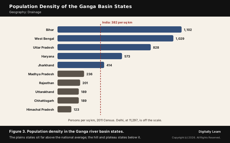
Density falls from the plains to the hills and plateaus. In 2011 Bihar had 1,102 persons per square km, West Bengal 1,029 and Uttar Pradesh 828, against 382 for India, while Uttarakhand had 189 and Madhya Pradesh 236. The reasons lie in land, soil and water:
- Land and soil: River plains and deltas, with their fertile alluvium and early settled agriculture, have always held a larger share of India’s people.
- Water supply: Climate, terrain and the availability of water largely decide where people live; perennial rivers and the Ganga and Yamuna canal systems irrigate vast areas.
- History and transport: An early history of settlement and a dense transport network keep numbers high even where land and water show signs of degradation.
- Large cities: Delhi, Kolkata, Kanpur, Lucknow, Patna, Agra, Meerut, Varanasi and Allahabad lie in the basin; its urban population grew by about 30 per cent between 2001 and 2011.
- Thinner margins: The Himalayan hills and the interior of the central plateau carry far fewer people.
Ganga River Dolphin, Dams and River Conservation
Ganga River Dolphin, Tehri Dam and Namami Gange
The Ganga is home to about 140 species of fish and to critically endangered species such as the gharial and the river dolphin. It is also a heavily used and polluted river, so its health is a national concern handled through the National Mission for Clean Ganga.
- Ganges river dolphin: Declared India’s National Aquatic Animal after the first meeting of the National Ganga River Basin Authority on 5 October 2009; it is critically endangered, an indicator of river health, and listed in Schedule I of the Wild Life (Protection) Act.
- Tehri Dam: A 260.5 m rock and earth-fill dam on the Bhagirathi in Uttarakhand, the tallest dam in India. Filling its reservoir since 2005 has cut the Bhagirathi’s flow, a cause of local protest.
- Pollution: Faecal coliform bacteria near Varanasi are more than 100 times the official limit, and the Ganga Action Plan is widely considered a failure.
- Namami Gange: Approved as a flagship programme in June 2014 with an outlay of Rs 20,000 crore. By February 2026, 355 of its 524 sanctioned projects had been completed.
Floods, pollution and the Namami Gange programme are covered in Rivers: Floods, Pollution and Conservation and in the current affairs page on Namami Gange.
Previous Year UPSC-CSE Questions
Previous Year UPSC-CSE Questions By the end you will be able to draft model answers for the following UPSC questions. Each question carries a collapsible framework showing how to approach it in the exam.
- UPSC Prelims 2013 Prelims-GSConsider the following pairs: National Park : River flowing through the Park
- Corbett National Park : Ganga
- Kaziranga National Park : Manas
- Silent Valley National Park : Kaveri
Which of the above pairs is/are correctly matched?
How to approach this Prelims question
Approach: Name the river of each park before reading the options.
Trap to watch: Corbett is on the Ramganga, a Ganga tributary, not on the Ganga itself.
Key facts to recall:
- (a) 1 and 2: wrong. Corbett lies in the Ramganga valley and Kaziranga on the Brahmaputra.
- (b) 3 only: wrong. Silent Valley gives rise to the Kunthipuzha, not the Kaveri.
- (c) 1 and 3: wrong. Both pairs name the wrong river.
- (d) None: right. All three pairs are mismatched.
Answer signal: None, option (d).
- UPSC Prelims 2004 Prelims-GSConsider the following statements:
- Damodar Valley Corporation is the first multipurpose river valley project of independent India.
- Damodar Valley Corporation includes thermal and gas power stations.
Which of these statements given above is/are correct?
How to approach this Prelims question
Approach: Recall what DVC was and what it runs.
Trap to watch: DVC is not only dams and hydel power; it also runs thermal and gas stations.
Key facts to recall:
- (a) 1 only: wrong. Statement 2 is also true: the DVC includes thermal and gas power stations.
- (b) 2 only: wrong. Statement 1 is true: the DVC was independent India's first multipurpose river valley project.
- (c) Both 1 and 2: right. Both facts hold for the Damodar Valley Corporation.
- (d) Neither 1 nor 2: wrong. Both statements are true.
Answer signal: Both 1 and 2, option (c).
- UPSC Mains 2025 GS-IDiscuss the distribution and density of population in the Ganga River Basin with special reference to land, soil and water resources.
Answer outline: how to structure the answer
What the question asks, the main arguments, relevant examples and the direction of the conclusion. This is not a full model answer.
Introduction: Open with the basin's size (about 26 per cent of India) and its share of population (about 43 per cent in 2001), making it the most populated river basin in the world.
Body (sub-themes to develop):
- Distribution: dense plains (Bihar, West Bengal, Uttar Pradesh) against thin hills and plateau (Uttarakhand, Madhya Pradesh).
- Land: fertile, flat Gangetic plains suited to intensive cultivation; 29.5 per cent of India's culturable area.
- Soil: deep alluvium on the plains against erodible mountain soils and black soils to the south.
- Water: perennial Himalayan rivers and canal irrigation; lean flows from December to May.
- Cities and history: early settlement, transport and large urban centres.
Conclusion: Conclude that the same land, soil and water that support the density now face pressure, which is why basin-wide planning and river rejuvenation matter.
Sources
- NCERT: India Physical Environment (Class XI), Drainage System
- NCERT: India People and Economy (Class XII), Population
- National Mission for Clean Ganga: Ganga basin location
- National Mission for Clean Ganga: Hydrology of the Ganga basin
- National Mission for Clean Ganga: Soils of the Ganga basin
- National Mission for Clean Ganga: Demography of the Ganga basin
- National Mission for Clean Ganga: Namami Gange Programme
- Central Water Commission: About Ganga Basin
- Central Water Commission: Yamuna Basin Organisation, basin details
- PIB (MoEF): Dolphin declared as a National Aquatic Animal, 14 December 2009
- PIB (Jal Shakti): Status of Namami Gange Programme, 23 March 2026
- Wikipedia: Ganges
- Wikipedia: Yamuna
- Wikipedia: Panch Prayag
- Wikipedia: Kosi River
- Wikipedia: Ghaghara
- Wikipedia: Son River
- Wikipedia: Damodar Valley Corporation
- Wikipedia: Jim Corbett National Park
- Wikipedia: Ganges Basin
- Wikipedia: Tehri Dam
- UPSC: Civil Services Examination question papers
Disclaimer
This article draws on the NCERT geography textbooks, the National Mission for Clean Ganga, the Central Water Commission and the other sources listed on this page. River lengths and basin figures differ slightly between sources.