

Overview
Himalayan rivers make up the Himalayan drainage, the network of rivers that begins in the Himalaya or on the Tibetan side of it and mainly consists of the Ganga, the Indus and the Brahmaputra basins. These rivers are fed both by melting snow and by rainfall, so they are perennial, which means they carry water in every month of the year. Inside the mountains they carve giant gorges and V‑shaped valleys, because they cut downward as fast as the Himalaya rises. On reaching the plains they slow down, drop their load and form flat valleys, oxbow lakes, floodplains, braided channels and deltas.
Origins of the Indus, Ganga and Brahmaputra Systems
Sources, Lengths and Mouths of the Three Systems
The three systems begin close together on and beyond the northern side of the Himalaya and then fan out to two different seas.
| River system | Origin | Length | Mouth |
|---|---|---|---|
| Indus | Glacier near Bokhar Chu in the Kailash range, Tibet, at 4,164 m | 2,880 km (1,114 km in India) | Arabian Sea, east of Karachi |
| Ganga | Gangotri glacier near Gaumukh at 3,900 m, as the Bhagirathi | 2,525 km | Bay of Bengal near Sagar Island |
| Brahmaputra | Chemayungdung glacier in the Kailash range near Mansarovar lake | Nearly 1,200 km in Tibet and 750 km in the Assam valley | Merges with the Padma, which falls in the Bay of Bengal |
NCERT gives the length of the Indus as 2,880 km; some other accounts give 3,180 km.
Indus River System and Its Tributaries
The Indus basin covers 11,65,000 sq km, of which 3,21,289 sq km lies in India. It is the westernmost Himalayan river of India. The Indus flows north-west between the Ladakh and Zaskar ranges, passes through Ladakh and Baltistan and enters Pakistan near Chilas. Its Himalayan tributaries include the Shyok, Gilgit, Zaskar, Hunza, Nubra, Shigar, Gasting and Dras, and the Kabul river joins it on the right bank near Attock.
Five rivers of Punjab, the Satluj (also written Sutlej), Beas, Ravi, Chenab and Jhelum, join to form the Panjnad, which meets the Indus a little above Mithankot. The Chenab, formed where the Chandra and Bhaga meet at Tandi near Keylong in Himachal Pradesh, is the largest tributary of the Indus. The Jhelum rises from a spring at Verinag, flows through Srinagar and the Wular lake and leaves for Pakistan through a deep narrow gorge.
Ganga Headstreams and the Brahmaputra's Course
The Ganga is the most important river of India in terms of its basin and cultural significance. The Bhagirathi from Gangotri meets the Alaknanda at Devprayag, and from there the combined river is the Ganga. The Alaknanda rises in the Satopanth glacier above Badrinath. The Ganga enters the plains at Haridwar and finally splits into two distributaries, the Bhagirathi and the Padma. The important left bank tributaries of the Ganga are the Ramganga, Gomati, Ghaghara, Gandak, Kosi and Mahananda; the Son is its major right bank tributary. The Yamuna, its westernmost and longest tributary, rises in the Yamunotri glacier and joins the Ganga at Prayag.
The Brahmaputra flows east for nearly 1,200 km through a dry, flat region of southern Tibet as the Tsangpo. It then turns around Namcha Barwa (7,755 m) and enters Arunachal Pradesh as the Siang or Dihang, west of Sadiya town. After it receives the Dibang and the Lohit it is known as the Brahmaputra. Its important right bank tributaries in Assam are the Subansiri, Kameng, Manas and Sankosh, and the Burhi Dihing and Dhansari (South) join on the left. It enters Bangladesh near Dhubri, where the Tista joins it and it becomes the Jamuna.

Why Himalayan Rivers Are Perennial: Snow, Glacier and Monsoon Flow
Snow and Glacier Feed of Himalayan Rivers
Himalayan rivers are perennial because they have two overlapping sources of water, the melting of snow and glaciers on the mountains and the rainfall of the monsoon. A river fed only by rain, like most Peninsular rivers, shrinks when the rains stop, but a river that also draws on stored ice keeps a base flow through the dry months.
The sources of individual rivers show the ice supply clearly. The Ganga begins in the Gangotri glacier and the Alaknanda in the Satopanth glacier, and the Yamuna begins in the Yamunotri glacier. The Bara Shigri glacier feeds the Chandra river, which becomes the Chenab after meeting the Bhaga, and the Zemu glacier drains the east side of Kanchenjunga and feeds the Tista. The Indus is fed by glaciers and rivers in the Himalayan, Karakoram and Hindu Kush ranges.
Monsoon Discharge and the Peninsular Contrast
The monsoon then adds the bulk of the water. In the Ganga basin about 84 per cent of the rainfall comes between June and September, and the ratio of dry season to monsoon discharge is about 1:6 at Hardinge Bridge. The Brahmaputra shows the same swing at a larger scale, with an average discharge of about 22,000 cumecs (cubic metres per second) that reaches about 1,03,000 cumecs in floods.
Peninsular rivers show the contrast. Most of them are non-perennial, and even the Kaveri, which carries water throughout the year, does so because its upper catchment gets the south-west monsoon in summer and its lower part gets the north-east monsoon in winter, which is a rain-based explanation and not a snow-based one.
Antecedent Rivers and Gorges Across the Rising Himalaya
What Makes a River Antecedent
An antecedent stream is one that keeps its original course and pattern even though the rock structure beneath it has changed. As the land rises slowly, the stream erodes through the rising ridge and forms a steep-walled gorge. Several Himalayan rivers are good examples because they originated well before the Himalayan region was uplifted. The Indus, Brahmaputra, Satluj, Kosi and Subansiri began on the Tibetan side and now cross the existing ranges, cutting deep gorges.
The mechanism has three steps:
- A river already flows across a land surface.
- Tectonic forces lift a ridge across its path.
- If the river cuts down as fast as the ridge rises, it holds its line and the ridge is sliced into a gorge.
The Himalaya was raised by the collision of the Indian plate with the Eurasian plate and is still rising by about 5 mm a year, so this cutting is continuing today. The headwaters of the Indus and the Yarlung Tsangpo flow along the Indus-Yarlung suture zone, the line where the Indian plate collided with the Eurasian plate about 50 million years ago.

Named Gorges of the Indus, Satluj and Brahmaputra
The gorges are the visible proof of antecedence, and each of the main rivers has at least one famous gorge.
- Indus gorge near Nanga Parbat: The Indus passes a gigantic gorge 4,500 to 5,200 m deep near the Nanga Parbat massif and bends sharply to the left after it, flowing south-south-west towards the plains.
- Satluj and Beas: The Satluj flows almost parallel to the Indus for about 400 km before entering India and comes out of a gorge at Rupar. The Beas forms gorges at Kati and Largi in the Dhauladhar range.
- Brahmaputra at Namcha Barwa: After flowing east along southern Tibet, the river carves a deep gorge at the eastern end of the Himalaya near Namcha Barwa. The Yarlung Tsangpo Grand Canyon is about 504.6 km long and its walls rise 5,000 m or more on each side. The river bends around the Namcha Barwa and Gyala Peri massifs and then turns south and south-west, which is the famous bend of the Brahmaputra.
- Kosi at Chatra: After the three streams that form the Kosi unite, the river flows in a narrow gorge for about 10 km and comes out into the plains near Chatra.
- Other gorges: The Ghaghara cuts a deep gorge at Shishapani and the Jhelum leaves Kashmir through a deep narrow gorge before entering Pakistan.
A deep gorge, a sharp bend where the river wraps around a rising massif, a set of parallel ranges and steep unstable slopes together mark the Himalaya as young fold mountains.
Evolution of the Himalayan Drainage: The Indo-Brahma River
The Shiwalik or Indo-Brahma River Hypothesis
Geologists do not agree on every detail of how the Himalayan rivers evolved, but the most widely taught account is the Shiwalik or Indo-Brahma river hypothesis. According to it, a mighty river called the Shiwalik or Indo-Brahma flowed along the whole length of the Himalaya, from Assam to Punjab and then on to Sind, and finally discharged into the Gulf of Sind near lower Punjab during the Miocene period, some 5 to 24 million years ago. The remarkable continuity of the Shiwalik hills, their lacustrine origin and their alluvial deposits of sand, silt, clay, boulders and conglomerates support this view.
In course of time this one river was dismembered into three drainage systems:
- The Indus and its five tributaries in the western part.
- The Ganga and its Himalayan tributaries in the central part.
- The Brahmaputra stretch in Assam and its Himalayan tributaries in the eastern part.
Two events caused the break-up. The first was the Pleistocene upheaval in the western Himalaya, including the uplift of the Potwar Plateau; together with the Delhi Ridge, the uplifted ground became the water divide between the Indus and Ganga systems. The second was the down-thrusting of the Malda gap area between the Rajmahal hills and the Meghalaya plateau in the mid-Pleistocene, which diverted the Ganga and the Brahmaputra towards the Bay of Bengal.
Youthful Erosion in the Mountains and Deposition on the Plains
Meanders, Oxbow Lakes and Braided Channels
Along its length a Himalayan river first erodes and then deposits. In the mountains, where the gradient is steep, it cuts down and carries material away. On the plains, where the gradient falls, it lays that material down. In the Himalayan reaches the course is highly tortuous, with rapids, waterfalls, V‑shaped valleys and gorges. Over the plains the rivers show a strong meandering tendency and shift their courses frequently.
The scale of the material moved is large. The combined Ganga, Brahmaputra and Meghna system carries a suspended sediment load of about 1.87 billion tonnes a year, the highest in the world, and the Ganga-Brahmaputra delta built by these flows is the world's largest delta, at about 64,000 sq km.
A meander is one of a series of regular sinuous curves in a river channel. The water erodes the outer concave bank (the cut bank) and deposits sediment on the inner convex bank, so the curve slowly migrates across the floodplain. When a wide meander is cut off during a flood, the abandoned loop becomes an oxbow lake, a U‑shaped lake that has been left behind. Kanwar Lake (Kabartal) in Begusarai district of Bihar is a residual oxbow lake formed by the meandering of the Burhi Gandak, a tributary of the Ganga. It covers 2,620 hectares, is described as Asia's largest freshwater oxbow lake and became the first Ramsar site of Bihar in November 2020.
A braided river has a network of channels separated by small, often temporary islands called braid bars. Braiding is common in rivers that have high sediment loads or coarse grain sizes, steeper slopes, rapid variation in flow and weak banks. The Brahmaputra is a classic example. In Assam its banks are more than 8 km apart during the rains, its average depth is about 30 m, its maximum depth is 135 m at Sadiya, and it follows a braided course of about 700 km through the valley. Its plains are known for riverine islands and sand bars.
Bhabar, Tarai, Bhangar and Khadar Belts
The alluvium brought down by the Indus, the Ganga and the Brahmaputra forms the northern plains, which extend about 3,200 km from east to west, with an average width of 150 to 300 km and alluvium that reaches a depth of 1,000 to 2,000 m. The Indo-Gangetic Plain built by these rivers covers about 7,00,000 sq km and holds nearly one-seventh of the world's population.
The northern plain is divided from north to south into the Bhabar, the Tarai and the alluvial plains, and the alluvial plains are further divided into the Khadar and the Bhangar.
- Bhabar: A narrow belt of 8 to 10 km along the foot of the Shiwalik hills, where the slope breaks. The rivers drop heavy rocks and boulders here, and at times disappear into the gravel.
- Tarai: A belt about 10 to 20 km wide south of the Bhabar, where the streams re-emerge without properly defined channels, creating marshy and swampy conditions, luxuriant natural vegetation and rich wildlife.
- Bhangar: The older alluvium, lying above the level of the usual flood.
- Khadar: The newer alluvium, lying low along the rivers and renewed by floods.
The order follows the logic of a river leaving the mountains. Heavy material settles first because the slope drops sharply, water that sank into the gravel returns as springs, and the fine silt travels farthest. The rich soil of the river valley plains supports crops such as wheat, rice, sugarcane and jute and a large population.

Doabs and Deltas of the Ganga-Brahmaputra Plain
A doab is the tract of land lying between two confluent rivers; the word comes from Persian do-ab, "two waters". The Himalayan rivers divide the plains into doabs, and within each doab the low floodplain beside the river is the fertile Khadar, and the higher land farther from the river, less prone to flooding, is the Bhangar. The best-known is the Ganga-Yamuna Doab, the flat alluvial tract between the two rivers from the Shiwalik hills to their confluence at Prayagraj.
At the sea the Ganga and Brahmaputra build a combined delta. The Ganga splits into the Bhagirathi and the Padma, and below its confluence with the Tista the Brahmaputra splits into two distributary branches, of which the western one, the Jamuna, carries most of the flow. The Sundarbans, the mangrove forest in this delta, spreads over 10,277 sq km between the Hooghly in West Bengal and the Baleswar in Bangladesh and is the world's largest mangrove forest; 4,260 sq km of it lies in West Bengal.
Course Shifting and Floods: The Kosi and the Brahmaputra
Sorrow of Bihar: Course Shifts and the Bhimnagar Barrage
Rivers that carry a very heavy load across a nearly level plain are unstable. The Kosi, known as the sorrow of Bihar, is the standard example. It brings huge quantities of sediment from its upper reaches and deposits them in the plains, the course gets blocked, and the river changes its course. The Kosi is formed by the confluence of the Sun Kosi, Arun Kosi and Tamur Kosi, which rise in Nepal and Tibet. It drains 74,500 sq km, of which only 11,070 sq km lies in India.
NCERT records that over the last 200 years the river has moved west by about 112 km, laying waste large tracts of farmland in Darbhanga, Saharsa and Purnea. Other estimates exceed 133 km, and a study of 28 historical maps found the movement random and oscillating, with a slight eastward drift over a long period. Either way, the Kosi has wandered widely across its alluvial fan, the cone of sediment it spreads where it leaves the hills.
Floods from such rivers are a recurring burden for Bihar. As reported in 2010, 22 of Bihar's 38 districts are flooded almost every year by rivers coming from Nepal, and about 70 per cent of the State's land is vulnerable to inundation.
Engineering tried to hold the river. The Kosi Barrage at Bhimnagar in Nepal, 1,149 m long with 56 gates and designed for a peak discharge of 27,000 cumecs, was completed in July 1963, and the Eastern Kosi Canal irrigates about 6.12 lakh ha in seven districts of Bihar. Yet the August 2008 flood breached the right afflux bund at Kusaha in Nepal and badly damaged the Eastern Kosi Canal system.
Brahmaputra Floods and Silt-Raised River Beds
The Brahmaputra is well known for floods, channel shifting and bank erosion because most of its tributaries are large and bring a large quantity of sediment from areas of heavy rainfall. It also floods in spring, when the Himalayan snow melts.
Flood frequency can rise even without more rain. Deposition of silt raises the river bed and so reduces the depth of the valley, which means that a smaller discharge is enough to overtop the banks.
Floods are not only a loss. The Brahmaputra delta region depends on the annual normal flood to bring moisture and fresh sediment to the soils, and two of its three seasonal rice crops, aus and aman, cannot survive without floodwater. The task is to keep the benefit and reduce the damage.
Himalayan Rivers Versus Peninsular Rivers: Key Differences
Age, Flow and Valleys of the Two Drainage Systems
The Peninsular drainage system is older than the Himalayan one, which is evident from its broad, largely graded shallow valleys and the maturity of its rivers.
| Feature | Himalayan rivers | Peninsular rivers |
|---|---|---|
| Main systems | Indus, Ganga, Brahmaputra | Mahanadi, Godavari, Krishna, Kaveri, with Narmada and Tapi flowing west |
| Age | Evolved through a long geological history with the uplift of the Himalaya | Older than the Himalayan drainage, with mature rivers |
| Flow | Perennial | Largely non-perennial, with Narmada, Tapi and the Kaveri as partial exceptions |
| Valleys | Giant gorges and V‑shaped valleys in the mountains | Broad, largely graded, shallow valleys |
| Course | Tortuous in the mountains, strongly meandering and shifting on the plains | Fixed course, absence of meanders |
| Depositional features | Oxbow lakes, floodplains, braided channels, deltas | East-flowing rivers form deltas; Narmada and Tapi lack alluvial and deltaic deposits |
| Direction | Indus to the Arabian Sea; Ganga and Brahmaputra to the Bay of Bengal | Western Ghats as divide; most flow west to east except Narmada and Tapi |
The direction of Peninsular rivers has a geological reason. The Western Ghats lie close to the western coast and act as the water divide, so rivers flowing west are only small rivulets joining the Arabian Sea. The Narmada and Tapi flow west in trough faults formed when the northern flank of the Peninsular block sank during the Himalayan upheaval, and they fill the original cracks with their detritus, so they build no deltas.
Subsidence of the western flank of the Peninsula below the sea in the early Tertiary also disturbed the symmetry of the drainage on either side of the original watershed. A slight tilt of the Peninsular block from the north-west to the south-east oriented the rest of the drainage towards the Bay of Bengal.
The Peninsula is also made up mostly of relict and residual mountains such as the Aravali, Nallamala, Javadi, Veliconda and Palkonda ranges and the Mahendragiri hills, and its river valleys are shallow with low gradients; it is the Himalayan rivers that cut deep V‑shaped valleys.
Drainage Patterns of Indian Rivers
The pattern of a drainage network records its geological history, rock structure, slope and the amount and timing of flow. Four patterns are common in India:
- Dendritic: Branches like those of a tree, as in the rivers of the northern plain.
- Radial: Rivers rising from a hill and flowing in all directions, as from the Amarkantak range in the Peninsula.
- Trellis: Primary tributaries run parallel and secondary tributaries join them at right angles, where hard and soft rocks lie parallel to each other.
- Centripetal: Rivers discharge from all directions into a lake or depression.
Antecedence links drainage pattern to uplift. A stream that was dendritic before uplift keeps its dendritic pattern across the rising ridge, even though the landscape it now crosses would normally produce a trellis pattern.
Irrigation, Navigation and Hydropower From Himalayan Rivers
Canals and Inland Navigation on Himalayan Rivers
Perennial flow makes Himalayan rivers the natural base for canals, waterways and power stations. The Satluj feeds the canal system of the Bhakra Nangal project, and the Yamuna feeds the Western and Eastern Yamuna canals and the Agra canal. The Bhakra Dam on the Satluj is 226 m high and its reservoir, Gobind Sagar, stores up to 9.34 billion cubic metres of water. Inter-basin schemes include the Indira Gandhi Canal Project and the Beas-Satluj Link Canal.
Navigation draws on the same steady flow. The Brahmaputra is navigable for most of its length. On the Ganga, the Jal Marg Vikas Project, approved by the Cabinet on 3 January 2018, improves navigation on the Haldia to Varanasi stretch of National Waterway‑1 through Uttar Pradesh, Bihar, Jharkhand and West Bengal. In contrast, the Peninsular Godavari is navigable only in its deltaic stretch.
Hydropower Potential of the Himalayan States
The Central Electricity Authority's reassessment of 2017 to 2023 puts the large hydro potential (projects above 25 MW) of India at about 133.4 GW. Much of it lies in the Himalayan states, led by Arunachal Pradesh.

Hydro projects mainly stand in hilly terrain, where floods sometimes damage temporary structures such as coffer dams and protection walls, and damaged roads and bridges delay the supply of materials.
Indus Waters Treaty and Other River Agreements
Water-Sharing Treaties on Himalayan Rivers
Himalayan rivers cross borders, so water sharing is part of their study. The Indus Waters Treaty was signed with Pakistan in 1960 and covers the main rivers of the Indus basin. The three Eastern rivers, the Satluj, Beas and Ravi, average around 33 million acre feet (MAF) and were allocated to India for unrestricted use. The three Western rivers, the Indus, Jhelum and Chenab, average around 135 MAF, and India must let their waters flow except for domestic, non-consumptive and other uses permitted in the treaty, which include the right to run-of-the-river hydroelectric projects subject to design criteria.
India built the Bhakra Dam on the Satluj, the Pong and Pandoh dams on the Beas and the Thein (Ranjitsagar) dam on the Ravi, with the Beas-Satluj Link and the Indira Gandhi Canal Project, and uses nearly 95 per cent of the Eastern rivers' share. About 2 MAF a year from the Ravi still flows unused to Pakistan below Madhopur. In 2025 India announced that the treaty would be held in abeyance with immediate effect until Pakistan credibly and irrevocably abjures its support for cross-border terrorism.
Other agreements follow the Ganga and its tributaries:
- Ganga Waters Treaty, 1996: With Bangladesh, sharing water at Farakka, the last control structure on the Ganga in India, in the lean period from 1 January to 31 May on a 10-day basis.
- Mahakali Treaty, 1996: With Nepal, covering the Mahakali (the Sarda in India), including the Sarda Barrage, Tanakpur Barrage and Pancheshwar Project.
- Kosi and Gandak agreements: The Kosi Agreement of 1954 (amended in December 1966) and the Gandak Agreement of 1959 (amended in April 1964), both with Nepal.
Glacier Retreat and the Future of Himalayan Rivers
Glacier Retreat in the Three Basins and Its Effects
The ice that keeps Himalayan rivers perennial is shrinking. The mean retreat rate of the Hindu Kush Himalayan glaciers is 14.9 m a year, which varies from 12.7 m a year in the Indus basin to 15.5 m in the Ganga and 20.2 m in the Brahmaputra basin. The Karakoram region shows comparatively minor length change. In the Chandra basin in the western Himalaya, six monitored glaciers have lost about 6 per cent of their glacial area in the last 20 years.
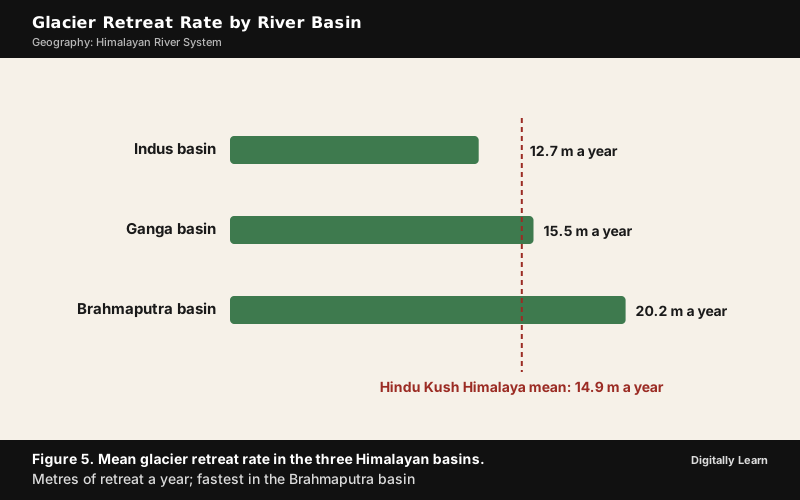
The effects on the rivers are of three kinds. The first is a shift in the seasonality of flow and greater year-to-year variability of runoff, which affects water supply from the mountains to the surrounding lowlands. The second is the formation and enlargement of glacial lakes, which raises the frequency of glacial lake outburst floods (GLOFs) and flash floods. The third is disruption of ecosystems and biodiversity and of the livelihoods of communities that depend on these water resources. Because ice-fed dry season flow is what makes the Indus, Ganga and Brahmaputra perennial, a change in melt affects that very feature.
India has set up a Steering Committee on Monitoring of Glacier under the Ministry of Jal Shakti (9 March 2023), a Centre for Cryosphere and Climate Change Studies at the National Institute of Hydrology, Roorkee (May 2023), and a procedure under the National Disaster Management Authority guidelines for responding to glacial lake outburst floods.
Previous Year UPSC‑CSE Questions
Each Prelims question is explained option by option, and each Mains question comes with an answer outline.
- UPSC Prelims 2026Identify the river of the Indian sub-continent on the basis of the following information:
- It has an antecedent drainage system.
- It flows through three countries.
- It originates in the Tibetan Plateau and is an important river for irrigation.
- It does not form distributaries.
Select the answer from the following:
How to approach this Prelims question
Approach: Test each river against the four clues. The Satluj, Brahmaputra and Indus are antecedent and begin in Tibet, so the first and third clues do not separate them. The Teesta flows through India and Bangladesh only. The last clue decides: The Brahmaputra splits into distributary branches and the Indus forks before the Arabian Sea, while the Satluj ends by joining the Chenab in the Panjnad, which meets the Indus, so it forms no distributaries of its own.
Trap to watch: The Brahmaputra and the Indus also fit the first three clues; only the last clue separates them.
Why each option is right or wrong:
- (a) Brahmaputra: Wrong. It meets the first three clues but splits into distributary branches below the Tista.
- (b) Indus: Wrong. It meets the first three clues but forks into distributaries before the Arabian Sea.
- (c) Sutlej: Correct. The Satluj is antecedent, flows through China, India and Pakistan, rises near Mansarovar, feeds the Bhakra canals and ends by joining other rivers, so it forms no distributaries.
- (d) Teesta: Wrong. It flows through India and Bangladesh only and rises in the eastern Himalaya, not on the Tibetan Plateau.
Answer: (c) Sutlej. The Satluj ends by joining the Chenab and the Indus, whereas the Brahmaputra and the Indus split into distributaries.
- UPSC Prelims 2026Which of the following geographical features or phenomena is/are associated with the Peninsular Block of India?
- Submergence of parts of the western coast due to tectonic activity
- Presence of residual mountain ranges such as the Veliconda hills and Mahendragiri hills
- Deep, V‑shaped river valleys formed by fast-flowing rivers
Select the answer using the code given below:
How to approach this Prelims question
Approach: Sort each item. Subsidence of the western flank of the Peninsula below the sea belongs to the Peninsular story. The Veliconda and Mahendragiri hills are relict and residual ranges of the Peninsula. Deep V‑shaped valleys belong to the Himalayan rivers; Peninsular valleys are shallow with low gradients.
Trap to watch: Fast-flowing rivers sound general, but deep V‑shaped valleys mark the young Himalaya.
Why each option is right or wrong:
- (a) 1 only: Wrong. Statement 2 is also correct.
- (b) 1 and 2: Correct. Western-flank subsidence and relict ranges are Peninsular features.
- (c) 2 and 3: Wrong. Statement 3 describes Himalayan rivers.
- (d) 3 only: Wrong. Statement 3 is wrong for the Peninsula.
Answer: (b) 1 and 2. Western-flank subsidence and residual ranges belong to the Peninsula; deep V‑shaped valleys come from the young Himalayan rivers.
- UPSC Prelims 2024With reference to the Himalayan rivers joining the Ganga downstream of Prayagraj from West to East, which one of the following sequences is correct?
How to approach this Prelims question
Approach: Place the four confluences on the Ganga below Prayagraj. The Gomati flows entirely in Uttar Pradesh and meets the Ganga first; the Ghaghara joins near Chhapra in Bihar; the Gandak joins at Sonpur near Patna; the Kosi joins farthest east, near Kursela.
Trap to watch: The Ghaghara is the bigger river, which tempts (a); the Gomati joins first, in Uttar Pradesh.
Why each option is right or wrong:
- (a) Ghaghara – Gomati – Gandak – Kosi: Wrong. The Gomati joins in Uttar Pradesh, before the Ghaghara near Chhapra.
- (b) Gomati – Ghaghara – Gandak – Kosi: Correct. This is the west-to-east order of the confluences.
- (c) Ghaghara – Gomati – Kosi – Gandak: Wrong. Both pairs are reversed.
- (d) Gomati – Ghaghara – Kosi – Gandak: Wrong. The Kosi joins near Kursela, east of the Gandak at Sonpur.
Answer: (b) Gomati – Ghaghara – Gandak – Kosi. The confluences run west to east from Uttar Pradesh (Gomati) to near Chhapra (Ghaghara), Sonpur (Gandak) and Kursela (Kosi).
- UPSC Prelims 2016Which of the following is/are tributary/tributaries of Brahmaputra?
- Dibang
- Kameng
- Lohit
Select the correct answer using the code given below.
How to approach this Prelims question
Approach: Recall the Brahmaputra's tributaries. The Dibang and the Lohit join the Siang or Dihang after it enters India, after which the river is called the Brahmaputra. The Kameng is a right bank tributary in the Assam valley.
Trap to watch: The Dibang and Lohit join before the river takes the name Brahmaputra, but they are still its tributaries.
Why each option is right or wrong:
- (a) 1 only: Wrong. It omits the Kameng and the Lohit.
- (b) 2 and 3 only: Wrong. It omits the Dibang.
- (c) 1 and 3 only: Wrong. It omits the Kameng.
- (d) 1, 2 and 3: Correct. The Dibang and the Lohit join from the left, the Kameng from the right.
Answer: (d) 1, 2 and 3. The Dibang, the Kameng and the Lohit all belong to the Brahmaputra system.
- UPSC Prelims 2013The Narmada river flows to the west, while most other large peninsular rivers flow to the east. Why?
- It occupies a linear rift valley.
- It flows between the Vindhyas and the Satpuras.
- The land slopes to the west from Central India.
Select the correct answer using the codes given below:
How to approach this Prelims question
Approach: Test each statement as a reason for the westward flow.
- Statement 1: The Narmada flows west in a rift valley, a trough fault formed as the northern flank of the Peninsular block sank during the Himalayan upheaval; correct.
- Statement 2: Lying between the Vindhyas and the Satpuras is true of its location but does not explain the direction; wrong as a reason.
- Statement 3: The Peninsular block as a whole tilts from the north-west to the south-east, so the land does not slope to the west; wrong.
Trap to watch: Lying between the Vindhyas and the Satpuras is true, but it says where the river is, not why it flows west.
Why each option is right or wrong:
- (a) 1 only: Correct. The linear rift valley is the reason the river runs west.
- (b) 2 and 3 only: Wrong. Statement 3 is false and statement 2 does not explain the direction.
- (c) 1 and 3 only: Wrong. The general slope of the Peninsula is to the south-east.
- (d) None: Wrong. Statement 1 is correct.
Answer: (a) 1 only. Rift-valley control, not the general slope, directs the Narmada west.
- UPSC Prelims 2012When you travel in Himalayas, you will see the following :
- Deep gorges
- U‑turn river courses
- Parallel mountain ranges
- Steep gradients causing landsliding
Which of the above can be said to be the evidences for Himalayas being young fold mountains?
How to approach this Prelims question
Approach: Check each feature against the marks of young fold mountains.
- Deep gorges: Rivers cut down as the Himalaya rises, as at Nanga Parbat and Namcha Barwa; correct.
- U‑turn courses: The Indus bends sharply after Nanga Parbat and the Brahmaputra turns around Namcha Barwa; correct.
- Parallel ranges: The Himalaya is a series of parallel ranges produced by folding; correct.
- Steep slopes and landslides: The range is still rising by about 5 mm a year; correct.
Trap to watch: Landslides may look like a weather effect, but the steep slopes come from continuing uplift.
Why each option is right or wrong:
- (a) 1 and 2 only: Wrong. It leaves out the parallel ranges and the steep slopes, which are also evidence.
- (b) 1, 2 and 4 only: Wrong. It leaves out the parallel ranges produced by folding.
- (c) 3 and 4 only: Wrong. It leaves out the gorges and the U‑turns.
- (d) 1, 2, 3 and 4: Correct. All four are features of a young, rising fold range.
Answer: (d) 1, 2, 3 and 4. Each feature comes from folding or from uplift that still continues.
- UPSC Prelims 2000Assertion and Reason:
- Assertion (A): The frequency of floods in North Indian plains has increased during the last couple of decades.
- Reason (R): There has been reduction in the depth of river valleys due to deposition of silt.
How to approach this Prelims question
Approach: Ask whether the Reason describes a process that could cause the Assertion. Himalayan rivers bring heavy sediment; where it settles, the bed rises and the valley becomes shallower, so a smaller discharge overtops the banks. The Reason therefore explains more frequent floods.
Trap to watch: Both statements are true; the test is whether the second explains the first.
Why each option is right or wrong:
- (a) Both A and R are true, and R is the correct explanation of A: Correct. Silt reduces channel depth, and shallower channels overflow more often.
- (b) Both A and R are true, but R is not a correct explanation of A: Wrong. Silt raising the bed is a direct cause of overflow.
- (c) A is true, but R is false: Wrong. Silt deposition on the plains is real, as the Kosi shows.
- (d) A is false, but R is true: Wrong. Repeated floods on the Kosi and the Brahmaputra fit the Assertion.
Answer: (a) Both A and R are true, and R is the correct explanation of A. Silt deposition reduces the depth and capacity of the channel, so floods come more often.
- UPSC Mains 2020 GS‑IHow will the melting of Himalayan glaciers have a far-reaching impact on the water resources of India?
Answer outline
The outline sets out what the question asks, the main arguments, relevant examples and the direction of the conclusion; it is not a full model answer.
Introduction: The Indus, Ganga and Brahmaputra are perennial because snow and glacier melt add to monsoon rain.
Body (sub-themes to develop):
- Seasonality: Shifts in the timing of runoff and greater year-to-year variability affect lowland water supply.
- Glacial lakes: New and enlarged lakes raise the risk of glacial lake outburst floods and flash floods.
- Dependent lives: Ecosystems, biodiversity and communities that rely on the rivers are disrupted.
- Basin differences: Retreat is fastest in the Brahmaputra basin (20.2 m a year) and slower in the Indus (12.7 m a year).
- Response: The glacier monitoring committee, the cryosphere centre at Roorkee and the glacial lake outburst flood (GLOF) guidelines.
Conclusion: Glacier retreat threatens the very feature that makes the Himalayan rivers perennial.
- UPSC Mains 2017 GS‑IIn what way can floods be converted into a sustainable source of irrigation and all-weather inland navigation in India?
Answer outline
Introduction: Floods are a hazard on the plains, but they also bring water and fresh silt.
Body (sub-themes to develop):
- Resource: Annual floods bring moisture and silt, and the aus and aman rice of the Brahmaputra delta depend on floodwater.
- Capture: Barrages and canals such as the Kosi Barrage and Eastern Kosi Canal turn peak flows into irrigation for 6.12 lakh ha.
- Transfer: Link canals such as the Beas-Satluj Link carry surplus water to deficit areas.
- Navigation: The Brahmaputra is navigable for most of its length, and on the Ganga the Jal Marg Vikas Project improves National Waterway‑1.
- Limits: Sediment blocks channels, and breaches such as the 2008 Kosi flood show the need to manage silt and embankments.
Conclusion: Managed well, the same perennial flow that floods the plains can water and connect them.
- UPSC Mains 2013 GS‑IThere is no formation of deltas by rivers of the Western Ghat. Why?
Answer outline
Introduction: The Western Ghats lie close to the western coast and act as the water divide.
Body (sub-themes to develop):
- Short courses: West-flowing rivers are short rivulets joining the Arabian Sea.
- Rift valleys: The Narmada and Tapi flow in trough faults and fill the cracks with detritus, so they leave no deltaic deposits.
- Subsidence: The western flank of the Peninsula sank in the early Tertiary, disturbing the drainage on the west.
Conclusion: Deltas form on the east coast, where long rivers with gentle gradients reach the sea.
Sources
- NCERT: India Physical Environment (Class XI), Drainage System
- NCERT: India Physical Environment (Class XI), Structure and Physiography
- India-WRIS: Kosi basin
- India-WRIS: Kosi Barrage and Eastern Kosi Canal project
- Press Information Bureau: Floods due to rivers from Nepal (2010)
- Press Information Bureau: Cabinet approves Jal Marg Vikas Project on the Haldia-Varanasi stretch of National Waterway‑1 (3 January 2018)
- Press Information Bureau: Hydropower potential from major and medium schemes is about 133.4 GW (27 July 2023)
- Press Information Bureau: Water treaties and agreements, Ministry of Jal Shakti (21 March 2022)
- Press Information Bureau: Indus Waters Treaty 1960, present status of development in India (22 February 2019)
- Press Information Bureau: Operation SINDOOR, India's strategic clarity and calculated force (14 May 2025)
- Press Information Bureau: Strategy on glacier and climate protection, Parliament question (31 July 2025)
- National Mission for Clean Ganga: Course of the Ganga
- Central Water Commission: Ganga basin
- Wikipedia: Indo-Gangetic Plain
- Wikipedia: Indus River
- Wikipedia: Bara Shigri
- Wikipedia: Zemu Glacier
- Wikipedia: Brahmaputra River
- Wikipedia: Ganges
- Wikipedia: Antecedent stream
- Wikipedia: Himalayas
- Wikipedia: Yarlung Tsangpo Grand Canyon
- Wikipedia: Meander
- Wikipedia: Oxbow lake
- Wikipedia: Kabartal Wetland
- Wikipedia: Braided river
- Wikipedia: Doab
- Wikipedia: Sundarbans
- Wikipedia: Kosi River
- Wikipedia: Bhakra Dam
- Wikipedia: Sutlej
- Wikipedia: Teesta River
- Wikipedia: Gomti River
- UPSC: Civil Services Examination question papers
Editorial Disclaimer
This article draws on the current NCERT geography textbooks, India-WRIS, the Press Information Bureau, the National Mission for Clean Ganga and the Central Water Commission. River lengths differ between sources; NCERT's are used.
See more of our UPSC articles in Google Search
Add to Preferred Sources