
Overview
Climate Part 1 of the climate-of-India cluster
How latitude, the Himalayan barrier, distance from the sea, altitude, and relief together build India's tropical-monsoon climate.
Previous Year UPSC-CSE Questions By the end you will be able to draft model answers for the following UPSC questions. Each question carries a collapsible framework showing how to approach it in the exam.
- UPSC Prelims 2024 General StudiesOn June 21 every year, which of the following latitude(s) experience(s) a sunlight of more than 12 hours?
- Equator
- Tropic of Cancer
- Tropic of Capricorn
- Arctic Circle
Select the correct answer using the code given below.
How to approach this Prelims question
Approach: Four-option evaluation testing the solar geometry of solstices and latitudinal sunlight duration.
Trap to watch: Aspirants may include the Equator believing it gets longer days on the summer solstice. The trap is that the Equator always gets 12 hours, regardless of season.
Key facts to recall:
- Tropic of Cancer: 23.44 degrees North; sun overhead on 21 June.
- Equator: Always gets exactly 12 hours of daylight.
- Tropic of Capricorn: 23.44 degrees South; sun overhead on 21 December.
- Arctic Circle: 66.56 degrees North; gets 24-hour sunlight on 21 June.
Answer signal: 2 and 4 only
- UPSC Prelims 2023 General StudiesConsider the following statements:
- Statement-I: The temperature contrast between continents and oceans is greater during summer than in winter.
- Statement-II: The specific heat of water is more than that of land surface.
Which one of the following is correct in respect of the above statements?
How to approach this Prelims question
Approach: Two-statement evaluation testing thermodynamic basis of continentality.
Trap to watch: Aspirants may accept Statement-I because summers feel hotter on land than over sea. The trap is the opposite: continents cool faster than oceans in winter, producing the larger winter contrast.
Key facts to recall:
- Specific heat of water: ~4.18 kJ/kg/degree Celsius; over four times that of dry soil.
- Continentality: Land surfaces heat and cool faster than oceans.
- Winter contrast: Greater than summer contrast because oceans retain summer heat into winter.
- Indian implication: Coastal cities (Mumbai, Chennai) have moderate annual range; interior cities (Delhi, Jaipur) have large annual range.
Answer signal: Statement-I is incorrect but Statement-II is correct
- UPSC Mains 2017 GS-IHow does the cryosphere affect global climate?
How to structure the answer in the exam
Introduction: Open by defining the cryosphere: the frozen-water component of Earth system comprising glaciers, ice sheets, sea ice, snow cover, and permafrost. The cryosphere covers approximately 10 per cent of Earth's land area and 7 per cent of global ocean.
Body (sub-themes to develop):
- Albedo effect: Snow and ice reflect ~80 per cent of incoming solar radiation; loss of cryosphere lowers planetary albedo and accelerates warming through positive feedback.
- Freshwater storage: Cryosphere holds ~70 per cent of Earth's freshwater; glaciers and ice caps store mountain freshwater reserves; Himalayan cryosphere is the largest non-polar ice mass.
- Sea-level regulation: Ice formation and melt control global sea level; Antarctic and Greenland ice sheet loss is currently the largest sea-level contributor.
- Ocean circulation: Sea-ice formation rejects salt; the denser saline water sinks and drives thermohaline circulation; cryosphere loss weakens this circulation.
- Atmospheric circulation: Cryosphere-atmosphere feedbacks affect jet stream behaviour; Arctic sea-ice loss linked to weakening of subtropical westerly jet and Indian monsoon variability.
- Indian context: Himalayan glaciers feed perennial rivers; the monsoon-cryosphere teleconnection (developed in our Himalayan Biodiversity entry) makes Indian climate sensitive to global cryosphere change.
Conclusion: Conclude by noting that the cryosphere is both a regulator and an early-warning indicator of global climate. Cryosphere loss accelerates warming through albedo feedback while Himalayan glacier retreat threatens Indian water security under climate change scenarios. International cooperation through the ICIMOD Hindu Kush Himalaya Assessment, the IPCC Special Report on Cryosphere and Oceans (2019), and the NMSHE mission under NAPCC frames the response.
The climate of India is described as tropical monsoon in overall character. The Tropic of Cancer at approximately 23.44 degrees North passes through the central belt of the country, placing the southern half in the tropical zone and the northern half in the sub-tropical and temperate zone. Indian climate is controlled by two broad groups of factors. The first group of location and relief factors comprises latitude, the Himalayan mountains, distribution of land and water, distance from the sea, altitude, and relief. The second group of air pressure and wind factors comprises the seasonal surface-pressure pattern, the upper-air jet-stream circulation, and the inflow of Western Disturbances and tropical depressions. Together these factor groups produce India's monsoon-dominated climate and the sharp regional diversity within it.
Background and Historical Context
India's climate sustains the agricultural calendar of over 1.4 billion people, governing the kharif and rabi cropping seasons that depend on the south-west monsoon and the Western Disturbance-driven winter precipitation respectively (covered in our Western Disturbances entry). The same climate shapes water resource availability through the Himalayan glacier-fed perennial rivers and the monsoon-fed peninsular rivers (covered in our Drainage Patterns entry). UPSC has examined Indian climate factors in Prelims and in Mains GS-I climatology papers across most cycles.
What is the significance of understanding climate factors as a system? Indian climate behaves as a coherent regime in which several structural drivers interact rather than act in isolation. The latitudinal location straddles the Tropic of Cancer with roughly half the land area in the tropical zone and half in the sub-tropical and temperate zone; this dual character generates the dual cropping-season economy and the strong north-south temperature gradient. The Himalayan mountain barrier blocks the cold continental air mass from Central Asia and traps the south-west monsoon, concentrating orographic rainfall on the southern slopes. The peninsular geometry places the southern coastlines under the maritime moderating influence of the Indian Ocean, while the deep interior of the Indo-Gangetic plain experiences continental thermal swings.
The latitudinal and altitudinal structure of Indian climate carries direct policy implications. Climate-change projections by the Indian Network for Climate Change Assessment (INCCA) indicate temperature rise across India of around 1.7-2.2 degrees Celsius by mid-century under current emission trajectories, with stronger warming in the trans-Himalayan zone than in the peninsular core. The National Action Plan on Climate Change (NAPCC), with its eight missions including the National Mission for Sustaining the Himalayan Ecosystem (covered in our Himalayan Biodiversity entry), responds to the climate-vulnerability stratification produced by these factors. The air-pressure-and-wind factors that shape Indian climate are developed in Climate Part 2 and Climate Part 3 of this cluster.
Weather and Climate: Two Layers of Atmospheric Behaviour
Distinguishing momentary weather from long-term climate
Weather describes the momentary state of the atmosphere at a particular place, capturing temperature, humidity, precipitation, cloud cover, wind speed and direction, and pressure. Climate describes the average of these same elements over a longer period, conventionally three decades or more. Weather can change within hours, while climate shifts so slowly that the change is perceptible only across multiple generations.
India's atmosphere combines two contrasting regimes within a single year, the south-west summer monsoon and the relatively dry winter. This shared seasonal rhythm is the reason the country's climatic identity is described as tropical monsoon, even though sub-tropical, temperate, alpine, and arid sub-types appear within different regions of the same system.
- Weather: Short-term atmospheric state; varies within a day or week.
- Climate: Statistical average of weather; conventionally measured over thirty-year periods.
- Indian climatic identity: Tropical monsoon, with sub-tropical, temperate, alpine, and arid sub-types in different regions.
- Unity and diversity: The monsoon rhythm is shared across the country, yet rainfall ranges from over eleven thousand millimetres at Mawsynram to under two hundred millimetres at Jaisalmer.
- Inter-annual variability: Indian climate varies significantly from year to year due to ENSO, the Indian Ocean Dipole, and other ocean-atmosphere teleconnections.
Two Groups of Factors That Control Indian Climate
Location and relief versus air pressure and wind
Indian climate behaves as a coherent regime because two groups of factors interact rather than act in isolation. The first group, location and relief, fixes the regional geographical setting: latitude, the Himalayan mountain wall, the distribution of land and water around the subcontinent, distance from the sea, altitude, and local relief.
The second group, air pressure and wind, animates that setting season by season: surface pressure and wind patterns, upper-air jet-stream circulation, and the inflow of Western Disturbances in winter and tropical depressions in summer. This article develops the six location-and-relief factors; the three air-pressure-and-wind factors are developed in Climate Part 2 and the seasonal mechanism in Climate Part 3.
| Group | Factors | Article focus |
|---|---|---|
| Location and relief | Latitude, Himalayan mountains, distribution of land and water, distance from the sea, altitude, relief | This article (Climate Part 1) |
| Air pressure and wind | Surface pressure-wind pattern, upper-air jet streams, inflow of Western Disturbances and tropical depressions | Climate Part 2 and Climate Part 3 |
Factor 1: Latitude and the Tropic of Cancer
Why India straddles tropical and sub-tropical zones
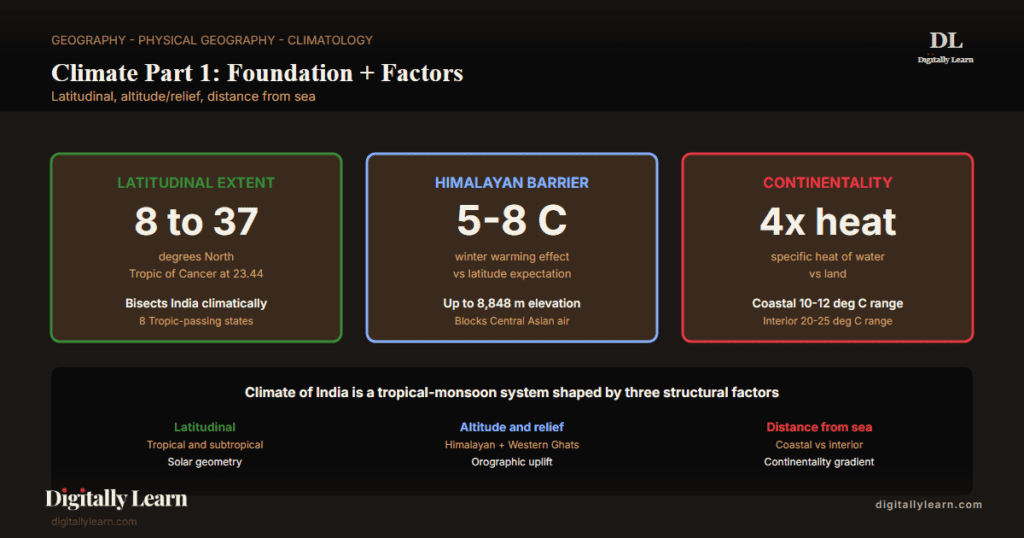
India extends from approximately 8 degrees North at Kanyakumari to 37 degrees North at the Karakoram range. The Tropic of Cancer, at approximately 23.44 degrees North, passes through the central belt of India in an east-west direction, partitioning the subcontinent climatically into two halves.
The part lying south of the Tropic of Cancer falls in the tropical zone, where temperatures remain high throughout the year and the daily and annual range stays small. The part lying north of the Tropic belongs to the sub-tropical and temperate zone, where summer heat and winter cooling produce a large annual range.
The Tropic of Cancer passes through eight Indian states, each at the climatic transition: Gujarat, Rajasthan, Madhya Pradesh, Chhattisgarh, Jharkhand, West Bengal, Tripura, and Mizoram. Stations south of the Tropic such as Bengaluru and Chennai record annual temperature ranges of seven to ten degrees Celsius, while stations north of it such as Delhi and Lucknow record ranges of twenty to twenty-five degrees.
The latitudinal division therefore explains the dual-seasonal experience of Indian agriculture and the strong north-south temperature gradient upon which the rest of the climate system overlays its effects.
Factor 2: The Himalayan Mountains as Climatic Divide
The shield that keeps India warm and traps the monsoon
The lofty Himalayan range, along with its eastern and western extensions, functions as an effective climatic divide. The towering mountain wall shields the subcontinent from cold northern winds that originate near the Arctic circle and sweep across central and eastern Asia. Were they not blocked, those winds would reach the Indo-Gangetic plain in winter as severe sub-zero blasts.
Because the wall intercepts them, northern India stays markedly warmer in winter than its 28-32 degree North latitude would otherwise suggest. This sheltering effect is why the Indo-Gangetic winter is mild rather than continental, unlike interior latitudes at comparable distance from the equator elsewhere in Asia.
The same Himalayan wall plays a second role in the summer monsoon season. The mountains trap the moist south-west monsoon winds and force them to ascend along the southern slopes. As the air rises it cools and releases its moisture as orographic rainfall, which is why the foothills of the Himalayas and the southern slopes of Meghalaya record some of the heaviest monsoon rainfall on Earth.
Without this barrier, the maritime monsoon flow would continue northward over Central Asia rather than depositing its moisture over the Indian plain. The wall therefore performs a dual service: it blocks cold air in winter and harvests monsoon moisture in summer.
- Cold-air blocking: Himalayan range blocks Arctic and Central Asian cold winds; keeps northern India warm in winter.
- Monsoon trap: South-west monsoon winds forced to ascend on southern slopes; release moisture as orographic rainfall.
- Climatic divide: The Himalayas separate the tropical and sub-tropical climate of South Asia from the cold continental climate of Central Asia.
- Without the barrier: The Indo-Gangetic plain would experience climate comparable to interior China at the same latitude, with sub-freezing winters.
Factor 3: Distribution of Land and Water
Differential heating drives the seasonal wind reversal
India is flanked by the Indian Ocean on three sides in the south and girdled by a high, continuous mountain wall in the north. This geometry sets up a sharp contrast between land and sea on a continental scale. Water heats and cools slowly because it has roughly four times the specific heat capacity of dry land.
As the seasons advance, the northern landmass heats faster than the ocean in summer and cools faster in winter. The result is a powerful differential heating between the Asian interior and the Indian Ocean, which creates contrasting air-pressure zones around the subcontinent from one season to the next.
- Summer setting: The heated land develops intense low pressure that draws moist oceanic air northward, producing the south-west monsoon.
- Winter setting: The cooled land develops high pressure that pushes dry continental air southward, producing the north-east winter monsoon.
- Driving variable: The wider the land-sea differential heating, the stronger the seasonal pressure gradient and the more vigorous the monsoon flow.
This seasonal pressure contrast is what drives the reversal of monsoon winds. The summer inflow and the winter outflow are mirror images of the same pressure mechanism, and that pressure-driven reversal of wind direction is precisely what gives the monsoon system its definitional identity.
Factor 4: Distance from the Sea
Equable coastal climate versus extreme interior climate
India's long coastline means that large coastal regions enjoy an equable climate, while regions in the deep interior lose the moderating influence of the sea and develop extremes of climate. Residents of Mumbai and the Konkan coast have almost no experience of severe summer-winter contrasts, because the Arabian Sea on their west keeps both seasons mild and humid.
Coastal stations therefore record annual temperature ranges of around ten to twelve degrees Celsius, the year's coldest month differing only modestly from its hottest. The maritime moderation compresses the seasonal swing that would otherwise follow from latitude alone.
The interior tells a different story. Cities like Delhi, Kanpur, and Amritsar lie hundreds of kilometres from the moderating ocean and feel its absence in every season. Summer maxima above 45 degrees Celsius alternate with winter minima near freezing, producing annual ranges of twenty to twenty-five degrees that govern urban life, agriculture, and energy demand.
The same continentality drives the extreme daily temperature swings of western Rajasthan, where the Thar Desert can see day-to-night differences exceeding twenty-five degrees Celsius within a single day. Distance from the sea thus widens both the seasonal and the diurnal range together.
| Setting | Representative cities | Annual temperature range | Climatic character |
|---|---|---|---|
| Maritime coastal | Mumbai, Chennai, Kochi, Visakhapatnam | Around 10-12 deg C | Mild equable; high humidity year-round |
| Interior peninsular | Pune, Hyderabad, Bengaluru | Around 13-17 deg C | Moderated by altitude plus inland location |
| Continental Indo-Gangetic | Delhi, Kanpur, Amritsar, Patna | Around 20-25 deg C | Sharp summer-winter contrast |
| Desert continental | Jaisalmer, Bikaner | Over 25 deg C daily range | Extreme thermal swings day to night |
Factor 5: Altitude
Temperature falls with elevation: the Agra-Darjeeling contrast
Temperature decreases with height because the air becomes thinner with elevation and can retain less heat. Mountain stations are therefore cooler than plains stations at the same latitude. The clearest Indian illustration is the contrast between Agra on the Indo-Gangetic plain and Darjeeling in the Eastern Himalayas, both lying close to the 27 degree North parallel.
Agra, at an elevation of around 170 metres, records a January mean temperature of about 16 degrees Celsius. Darjeeling, at over 2,000 metres, records a January mean of just 4 degrees Celsius. The twelve-degree gap reflects altitude alone, since latitude is held constant between the two stations.
- Atmospheric lapse rate: Temperature falls by roughly 6.5 degrees Celsius per 1,000 metres of elevation rise in the troposphere.
- Same-latitude contrast: Agra plain 16 degrees Celsius January mean versus Darjeeling hills 4 degrees Celsius at the same 27 degree North latitude.
- Vertical climate zonation: The Himalayan slopes telescope tropical, temperate, sub-alpine, and alpine climate belts into a few hundred kilometres of horizontal distance.
- Hill stations: Shimla, Mussoorie, Nainital, Ooty, Mahabaleshwar all owe their cool summer climate to altitude, despite lying at latitudes that would otherwise produce hot summers.
Factor 6: Relief and the Windward-versus-Leeward Asymmetry
Mountain orientation decides where rain falls
The physiography or relief of India shapes climate in ways that go beyond average elevation. The orientation of mountain slopes to incoming moisture-laden winds decides where rainfall is heavy and where it stays light. The windward western slopes of the Western Ghats face the moist south-west monsoon directly and receive heavy rainfall between June and September.
Immediately east of the Ghats, the leeward southern plateau stays dry under the rain-shadow effect. The same windward-leeward asymmetry operates in the north-east, where the southern slopes of the Assam-Meghalaya hills receive the heaviest monsoon rainfall on Earth while the interior valleys see comparatively less.
Relief also redirects winds, slows them, and forces them to ascend, producing weather that the surrounding plains never experience. The Aravalli range, the Vindhya-Satpura system, the Eastern Ghats, and the Khasi-Jaintia hills together explain the patchwork of rainfall and temperature zones that Indian climate maps display.
Where the relief lies parallel to the monsoon wind the rainfall is light; where it stands perpendicular to the wind the rainfall is heavy. Mawsynram and Cherrapunji in the Khasi hills hold the world records for annual rainfall, a direct consequence of relief geometry meeting moisture-laden Bay of Bengal monsoon flow.
| Side of relief | Region | Annual rainfall character | Representative stations |
|---|---|---|---|
| Windward to south-west monsoon | Western Ghats western slopes | Heavy orographic rainfall 250-500 cm | Mahabaleshwar, Agumbe, Munnar |
| Leeward (rain shadow) | Deccan plateau east of Western Ghats | Light rainfall 50-100 cm | Pune, Bijapur, Bellary |
| Windward to Bay of Bengal monsoon | Khasi-Jaintia hills southern slopes | Among the world's heaviest above 1,000 cm | Mawsynram (over 11,000 mm), Cherrapunji |
| Leeward | Interior Brahmaputra valley | Moderate 200-300 cm | Tezpur, Jorhat |
Air Pressure and Wind: The Second Group of Factors
A bridge to Climate Parts 2 and 3
The six location-and-relief factors fix the geographical stage. The second group animates that stage through the seasonal cycle of pressure and wind. Surface pressure and winds shift between a winter pattern dominated by a high-pressure cell north of the Himalayas and a summer pattern dominated by the Inter-Tropical Convergence Zone over the Indo-Gangetic plain.
Upper-air jet streams bifurcate at the Tibetan Plateau, the subtropical westerly jet steering winter weather and the tropical easterly jet establishing only after the westerly jet retreats north for summer. Inflow of disturbances brings Western Disturbances from the Mediterranean in winter and tropical depressions from the Bay of Bengal during the south-west monsoon.
- Air-pressure and wind factor 1: Distribution of air pressure and surface winds across seasons.
- Air-pressure and wind factor 2: Upper-air circulation including subtropical westerly jet and tropical easterly jet.
- Air-pressure and wind factor 3: Inflow of Western Disturbances in winter and tropical depressions during the south-west monsoon.
- Deep-dive coverage: The three air-pressure-and-wind factors are developed in Climate Part 2; the seasonal monsoon mechanism is developed in Climate Part 3.
Observable Outcomes of the Six-Factor System
How the factors produce the lived climate of India
The interaction of the six location-and-relief factors produces a small number of distinctive features that define the Indian climatic experience.
- Bi-seasonal agricultural calendar: The kharif and rabi cropping seasons follow the south-west monsoon and the Western Disturbance regime respectively, sustaining the food economy of over 1.4 billion people.
- Maritime versus continental contrast: Coastal stations record annual temperature ranges of 10-12 degrees Celsius while interior Indo-Gangetic stations record 20-25 degrees, producing very different daily life rhythms.
- Orographic rainfall hotspots: Mawsynram, Cherrapunji, the windward Western Ghats, and the Assam hills concentrate the world’s heaviest monsoon rainfall while the Deccan rain-shadow zone and western Rajasthan receive a small fraction.
- Altitudinal climate zonation: The Himalayan slopes telescope tropical, temperate, sub-alpine, and alpine climate belts into a few hundred kilometres of horizontal distance, supporting India’s biodiversity richness.
- Winter precipitation supply: The Himalayan barrier blocks Central Asian cold air and channels Western Disturbances along the subtropical westerly jet, delivering rabi-season precipitation to north-western India.
- Cyclonic risk asymmetry: The Bay of Bengal coast receives the bulk of post-monsoon tropical cyclones while the Arabian Sea coast remains comparatively quieter; the asymmetry reflects sea-surface temperature and atmospheric-shear conditions tied to the factor system.
These six outcomes together justify why the Indian Network for Climate Change Assessment and the National Action Plan on Climate Change stratify adaptation policy by climate zone rather than by political boundary; the underlying factor system, not state lines, determines vulnerability.
Prelims MCQ practice
Each question below tests one specific concept on the topic. Click to reveal the answer and a full option-wise explanation.
Q1. Consider the following statements about latitude as a determinant of India's climate:
- The Tropic of Cancer (23.5 deg N) passes roughly through the middle of India, dividing the country into a tropical south and a sub-tropical north.
- The Tropic of Cancer passes through eight Indian states including Gujarat, Madhya Pradesh, and West Bengal.
Which of the statements given above is/are correct?
- 1 only
- 2 only
- Both 1 and 2
- Neither 1 nor 2
Show answer and explanation
Answer: Both 1 and 2
Explanation.
Correct: c (Both 1 and 2). Both statements are correct. The Tropic of Cancer (around 23.5 deg N) passes through the middle of India, dividing it into a tropical south (closer to the equator) and a sub-tropical north (further from the equator). It passes through eight Indian states: Gujarat, Rajasthan, Madhya Pradesh, Chhattisgarh, Jharkhand, West Bengal, Tripura, and Mizoram.
Q2. Consider the following statements about the Himalayas as a climate barrier:
- The Himalayas block the cold continental winds from Central Asia from entering the Indian Subcontinent.
- The Himalayas force the southwest monsoon winds to rise and deliver heavy orographic rainfall along their southern slopes.
- Without the Himalayas, the Indian climate would resemble that of similar latitudes elsewhere (much colder winters and weaker monsoons).
Which of the statements given above are correct?
- 1 and 2 only
- 2 and 3 only
- 1 and 3 only
- 1, 2 and 3
Show answer and explanation
Answer: 1, 2 and 3
Explanation.
Correct: d (1, 2 and 3). All three are correct. The Himalayas block cold continental Central-Asian winds (which is why northern India is warmer in winter than equivalent latitudes elsewhere). The Himalayas force the southwest monsoon to rise, delivering heavy orographic rainfall along their southern slopes. Without the Himalayas, the Subcontinent's climate would have much colder winters and significantly weaker monsoons.
Q3. Consider the following statements about ocean influence on India's climate:
- The Indian Ocean, comprising the Bay of Bengal, the Arabian Sea, and the southern Indian Ocean, is a major source of monsoon moisture.
- The Bay of Bengal feeds the eastern (Bay) branch of the southwest monsoon, while the Arabian Sea feeds the western branch.
Which of the statements given above is/are correct?
- 1 only
- 2 only
- Both 1 and 2
- Neither 1 nor 2
Show answer and explanation
Answer: Both 1 and 2
Explanation.
Correct: c (Both 1 and 2). Both statements are correct. The Indian Ocean is the primary moisture source for the Indian monsoon. The southwest monsoon splits into two branches over the Subcontinent: the Arabian Sea branch (hits Kerala first, sweeps north along the Western Ghats and inland) and the Bay of Bengal branch (curves up the Bay, strikes NE India, and turns westward along the Himalayan foot).
Q4. Consider the following statements about continentality as a climate determinant:
- Coastal areas of India have a moderate climate due to maritime influence.
- Interior areas (Punjab, Rajasthan, central India) experience extreme temperature variations between summer and winter.
Which of the statements given above is/are correct?
- 1 only
- 2 only
- Both 1 and 2
- Neither 1 nor 2
Show answer and explanation
Answer: Both 1 and 2
Explanation.
Correct: c (Both 1 and 2). Both statements are correct. Coastal areas (Mumbai, Chennai, Kerala, coastal Karnataka) have moderate climate due to maritime influence (water moderates temperature). Interior continental areas (Punjab, Rajasthan, central India) experience extreme temperature variations, very hot summers and cold winters, due to continentality.
Q5. Consider the following statements about altitude as a determinant of Indian climate:
- Temperature decreases with altitude, so hill stations such as Shimla, Darjeeling, and Ooty have much cooler climates than nearby plains at the same latitude.
- Atmospheric pressure also decreases with altitude.
Which of the statements given above is/are correct?
- 1 only
- 2 only
- Both 1 and 2
- Neither 1 nor 2
Show answer and explanation
Answer: Both 1 and 2
Explanation.
Correct: c (Both 1 and 2). Both statements are correct. Temperature decreases with altitude at the normal lapse rate of around 6.5 deg C per km, so hill stations are markedly cooler than nearby plains at the same latitude. Atmospheric pressure also decreases with altitude (around 50 per cent of sea-level pressure at 5,500 m).
Q6. Consider the following statements about upper-air circulation and Indian climate:
- The sub-tropical westerly jet stream over the Himalayas in winter brings cyclonic disturbances (western disturbances) that produce winter rainfall in northwestern India.
- The tropical easterly jet stream over peninsular India in summer is associated with monsoon onset and active phases.
Which of the statements given above is/are correct?
- 1 only
- 2 only
- Both 1 and 2
- Neither 1 nor 2
Show answer and explanation
Answer: Both 1 and 2
Explanation.
Correct: c (Both 1 and 2). Both statements are correct. The sub-tropical westerly jet stream sits south of the Himalayas in winter and steers western disturbances that produce winter rain/snow in northwestern India and the western Himalayas. The tropical easterly jet (TEJ) over peninsular India in summer is associated with monsoon onset and active phases.
Sources and Further Reading
- NCERT Class 11 India: Physical Environment, Chapter 4 – Climate
- Wikipedia – Climate of India
- Wikipedia – Tropic of Cancer
- Wikipedia – Himalayas
- Wikipedia – Western Ghats
- Wikipedia – Indian Ocean
- Wikipedia – Monsoon of South Asia
- Wikipedia – Continental climate
- Wikipedia – Orographic lift
- Wikipedia – National Action Plan on Climate Change
- Wikipedia – India Meteorological Department
Disclaimer
This article explains the location and relief factors that shape India's climate, prepared for UPSC-CSE. It draws on NCERT and standard climatology references.


