
Overview
Previous Year UPSC-CSE Questions By the end you will be able to draft model answers for the following UPSC questions. Each question carries a collapsible framework showing how to approach it in the exam.
- Prelims 2010With reference to the river Luni, which one of the following statements is correct?
How to approach this Prelims question
Approach: Recall that the Luni is the only major Indian inland-drainage river that terminates in the marshy Rann of Kachchh without reaching the Arabian Sea proper. The other three options describe outcomes that do not match the Luni's known geography.
Trap to watch: Option A (Gulf of Khambhat) is the trap, because the Narmada and the Tapti reach the Arabian Sea via the Gulf of Khambhat. The Luni does NOT; it terminates inland.
Key facts to recall:
- Luni source: Naga Hills of Pushkar valley, Aravalli Range, near Ajmer at about 550 m.
- Length: about 495 km across Thar Desert.
- Becomes saline downstream of Balotra.
- Terminus: marshy Rann of Kachchh in Gujarat, not the Arabian Sea proper.
Answer signal: Lost in the marshy land of the Rann of Kuchchh (option d).
- Prelims 2007Which one among the following rivers originates at Amarkantak?
How to approach this Prelims question
Approach: Amarkantak Plateau in Anuppur district of MP gives rise to three major Indian rivers: the Narmada (west-flowing into Arabian Sea), the Son (Ganga tributary, covered in Part 7), and the Mahanadi (Peninsular east-flowing, covered in Part 10). Among the four options, only the Narmada is correct.
Trap to watch: Mahanadi is also Amarkantak-related but its primary source is at Nagri-Sihawa in Chhattisgarh, not Amarkantak proper. The UPSC convention for this question accepts only the Narmada.
Key facts to recall:
- Amarkantak Plateau: Anuppur district, Madhya Pradesh.
- Narmada source elevation: 1,048 m.
- Son also rises here as a Ganga tributary.
- Damodar rises in Chhotanagpur, not Amarkantak.
- Tapti rises at Multai, not Amarkantak.
Answer signal: Narmada (option c).
- Prelims 2022Consider the following pairs: Reservoirs – States
- Ghataprabha – Telangana
- Gandhi Sagar – Madhya Pradesh
- Indira Sagar – Andhra Pradesh
- Maithon – Chhattisgarh How many pairs given above are not correctly matched?
How to approach this Prelims question
Approach: Verify each pair. Ghataprabha is in Karnataka not Telangana (Pair 1 NOT correctly matched). Gandhi Sagar is on the Chambal in Madhya Pradesh (Pair 2 correctly matched). Indira Sagar is on the Narmada in Madhya Pradesh, not Andhra Pradesh (Pair 3 NOT correctly matched). Maithon is on the Barakar in the Damodar Valley Corporation network across Jharkhand-West Bengal, not Chhattisgarh (Pair 4 NOT correctly matched). Three pairs are NOT correctly matched.
Trap to watch: Question asks how many are NOT correctly matched, not how many ARE correctly matched. Reading the question stem carefully avoids the inversion error.
Key facts to recall:
- Ghataprabha Reservoir: Karnataka (Krishna basin), not Telangana.
- Gandhi Sagar: Madhya Pradesh on the Chambal (Yamuna tributary).
- Indira Sagar: Madhya Pradesh on the Narmada at Punasa, not Andhra Pradesh.
- Maithon: Damodar Valley Corporation network across Jharkhand-West Bengal, not Chhattisgarh.
Answer signal: Three pairs NOT correctly matched (option c).
- UPSC Mains 2013 GS-IThere is no formation of deltas by rivers of the Western Ghat. Why?
How to structure the answer in the exam
Introduction: The west-flowing Peninsular rivers, including the Narmada and the Tapti from the Vindhya-Satpura rift and the many Western Ghat rivers from the Sahyadri, all reach the Arabian Sea through estuaries rather than deltas. Three structural reasons combine to produce this result.
Conclusion: The combined effect of low sediment supply, narrow coastal plain, and strong tidal erosion produces the universal estuary-not-delta geometry of west-flowing Peninsular rivers, in clear contrast to the major deltas of east-flowing rivers like the Mahanadi, Godavari, Krishna, and Kaveri.
What Defines the Peninsular West-Flowing and Inland-Drainage Family
Three Rivers, Two Rift Valleys, and One Inland Terminus
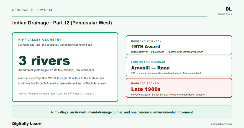
Definition: The Peninsular west-flowing rivers and the inland drainage family together cover three structurally distinct streams of the Indian peninsula. The Narmada (about one thousand three hundred and twelve kilometres) and the Tapti (about seven hundred and twenty-four kilometres) occupy rift valleys between the Vindhya and Satpura ranges, flow west, and reach the Arabian Sea through estuaries on the Gujarat coast.
The Luni (about four hundred and ninety-five kilometres) rises in the Aravalli Hills, flows south-west across the Thar Desert, and terminates in the marshy Rann of Kachchh without ever reaching the sea proper.
Why it matters: These three rivers together cover the western half of the Peninsular drainage family and contain three diagnostic phenomena that the east-flowing rivers of Parts 10 and 11 do not display. First, the rift-valley geometry of the Narmada and the Tapti is the clearest Indian case of structurally controlled drainage, covered in Part 3 of this series.
Second, the no-delta feature is universal across the west-flowing family because of the narrow Arabian Sea coastal plain. Third, inland drainage as a geomorphic category is operationally present only in the Luni and the inland streams of Rajasthan.
Three Structural Features That Govern Western and Inland Drainage
What is the significance of this river family for Indian geography? The three structural features have direct policy consequences. Rift-valley drainage means the Narmada and the Tapti accept narrow lateral inputs (limited tributary catchments), so their basin-water arithmetic is sharply constrained compared to east-flowing dendritic networks.
The no-delta feature means coastal Gujarat does not have the soft-sediment delta that the Bengal coast enjoys; coastal agriculture and aquaculture have to manage without that soft-sediment base. The inland-drainage feature means west Rajasthan cannot rely on any year-round freshwater stream; the Indira Gandhi Canal from the Sutlej (Indus system) is the working substitute. Together the three anomalies define the western half of Indian drainage governance.
| River | Source | Length (km) | Terminus |
|---|---|---|---|
| Narmada | Amarkantak, MP (1,048 m) | 1,312 | Gulf of Khambhat, Arabian Sea |
| Tapti | Multai, MP | 724 | Gulf of Khambhat, near Surat |
| Luni | Pushkar Aravalli, Rajasthan (~550 m) | 495 | Rann of Kachchh marshland |
The Narmada Rift-Valley System
Amarkantak Origin and the Vindhya-Satpura Rift
The Narmada rises at the Amarkantak Plateau in Anuppur district of Madhya Pradesh at an elevation of one thousand and forty-eight metres. The river runs about one thousand three hundred and twelve kilometres west across Madhya Pradesh, Maharashtra, and Gujarat, and drains a basin of about ninety-eight thousand seven hundred and ninety-six square kilometres.
The basin spans four states, with Madhya Pradesh holding eighty-two per cent, Gujarat twelve per cent, Maharashtra four per cent, and Chhattisgarh two per cent. The Amarkantak source is also the rising point of the Son (Ganga tributary, covered in Part 7) and the Mahanadi (covered in Part 10), giving the plateau a radial-drainage character covered in Part 2 of this series.
The defining structural feature of the Narmada is its rift-valley setting. The river flows between the Vindhya range to the north and the Satpura range to the south as a graben between two parallel fault lines, the clearest Indian case of structurally controlled drainage, covered in Part 2 of this series.
The river also produces the famous Marble Rocks at Bhedaghat near Jabalpur, where the channel runs for three kilometres in a deep, narrow gorge through limestone and basalt formations. The lower reach drains into the Gulf of Khambhat approximately thirty kilometres west of Bharuch.
Sardar Sarovar, Indira Sagar, and the Narmada Bachao Andolan
Three multi-purpose dams govern the working geography of the Narmada. The Sardar Sarovar Dam at Navagam in Kevadia (Narmada district of Gujarat) is the marquee structure: one thousand two hundred and ten metres long and one hundred and thirty-eight point six eight metres high.
The Indira Sagar Dam at Punasa in Madhya Pradesh is the principal upstream reservoir. The Omkareshwar Dam sits between Indira Sagar and Sardar Sarovar. Together the three dams form the central control architecture for Narmada water allocation under the 1979 Narmada Water Disputes Tribunal award.
The Narmada Bachao Andolan began in the late 1980s as a movement against the Sardar Sarovar height-and-rehabilitation question. The case reached the Supreme Court, which in October 2000 delivered a two-to-one majority verdict permitting construction up to ninety metres initially, with subsequent height-increase clearances dependent on rehabilitation progress.
The dam was finally inaugurated by Prime Minister Narendra Modi in 2017 and reached its highest water level of one hundred and thirty-eight point seven metres on 15 September 2019. The Sardar Sarovar case is a leading example of how the Indian judiciary mediates between dam-displacement social cost and water-resource development.
The Tapti System Between the Satpuras and the Arabian Sea
Source at Multai and Course Through Three States
The Tapti (also spelled Tapi) rises at Multai in Betul district of Madhya Pradesh. The river runs about seven hundred and twenty-four kilometres west through Madhya Pradesh, Maharashtra, and Gujarat, draining a basin of about sixty-two thousand two hundred and twenty-five square kilometres.
The course parallels the Narmada to the south, with the Satpura range separating the two rivers. The Tapti is sometimes treated as a partner of the Narmada in the rift-valley family, although its rift geometry is less pronounced than the Narmada's.
The Tapti reaches the Arabian Sea through the Gulf of Khambhat near Dumas in Surat. The 2003 UPSC Prelims sequence question (covered in Part 10 of this series) confirmed the Tapti as the shortest of the four major Peninsular rivers Godavari-Narmada-Mahanadi-Tapti. The lower reach is controlled by the Ukai Dam in Gujarat, which is the principal reservoir on the river and supports irrigation, hydropower, and flood-moderation for the Surat industrial belt.
Tapti Tributaries and the Ukai Reservoir
The Tapti accepts tributaries from both banks across its course. The left-bank tributaries are the Girna and the Purna, both rising in Maharashtra. The right-bank tributaries are the Gomai and the Aner, also in Maharashtra.
The combined tributary system gives the Tapti a modest dendritic character within its rift-confined main stem. The Ukai Reservoir impounded behind the Ukai Dam is the largest single body of water in the basin and supports the working core of Tapti water management for Gujarat.
The Tapti basin contains less hydropower potential than the Narmada basin because of the shorter river length and the smaller catchment. The principal use of Tapti water is therefore agricultural irrigation across the northern Maharashtra and southern Gujarat plains.
The basin is also the base of the proposed Par-Tapi-Narmada link under the National River Linking Project, which would transfer water from the Par and the Tapti to the Narmada and onward to the Sabarmati basin in northern Gujarat. The link remains under feasibility study as of the writing of this article.
The Luni and the Inland Drainage of Western Rajasthan
Why Inland Drainage Is a Distinct Geomorphic Category
Inland drainage is the geomorphic category in which a river system never reaches the sea. The river terminates in a closed basin, an evaporating sink, or a salty marsh. Inland drainage is rare in India because the subcontinental slope generally directs water toward either the Arabian Sea or the Bay of Bengal.
The only substantial Indian example is the Luni system of western Rajasthan, together with several small ephemeral streams that disappear into the Thar Desert or terminate in the Sambhar salt lake.
The defining geographic setting of Indian inland drainage is the Thar Desert with its low and uncertain rainfall (under two hundred and fifty millimetres annually in much of the region), combined with the rain-shadow effect of the Aravalli Hills.
Surface water that does form during the brief monsoon season cannot maintain a continuous course to the sea against the high evaporation rates and the porous desert floor. The resulting drainage either dissipates into the desert sands or terminates in a salty marsh, which is exactly the case of the Luni.
Luni from Pushkar Aravallis to the Rann of Kachchh
The Luni rises in the Naga Hills of the Pushkar valley of the Aravalli Range, near Ajmer, at an elevation of about five hundred and fifty metres. The river runs about four hundred and ninety-five kilometres south-west across the Thar Desert and drains a basin of about thirty-seven thousand three hundred and sixty-three square kilometres across multiple districts of Rajasthan and Gujarat. The upper reach remains fresh as it crosses the lower Aravalli foothills.
The river becomes saline downstream of Balotra because of the high salt content in the soil of the southern Rajasthan desert, transforming the water quality as it progresses through arid regions. The lower reach is therefore unsuitable for irrigation use. The terminus is the Rann of Kachchh in Gujarat, where the Luni dissipates into the marshy expanse without reaching the Arabian Sea proper. The 2010 UPSC Prelims tested precisely this inland-drainage feature, confirming the Luni's terminus in the marshy Rann.
Why West-Flowing Peninsular Rivers Do Not Form Deltas
Three Structural Reasons for the No-Delta Geometry
Observable outcomes: The west-flowing Peninsular rivers all reach the Arabian Sea through estuaries rather than deltas. Three structural reasons combine to produce this result, listed below.
- Limited sediment: The rift-valley course of the Narmada and the Tapti accepts only narrow lateral tributary inputs, so sediment yield per kilometre of channel is far lower than the Himalayan rivers covered in Parts 5 to 9 of this series.
- Narrow coastal plain: The Arabian Sea coastal plain between the Western Ghats and the sea is narrow (under one hundred kilometres at most points), providing no broad soft-sediment base on which a delta can spread laterally.
- Steep shelf and strong tidal action: The steep continental shelf and the strong tidal action of the Arabian Sea erode any nascent delta lobe before it can stabilise.
The result is that the Narmada enters the Gulf of Khambhat as a wide tidal estuary rather than building a delta; the Tapti exhibits the same pattern at Surat. The standard answer to the west-coast no-delta question rests on the three reasons above.
The contrast with the Mahanadi and Godavari deltas of Part 10 and the Krishna-Kaveri deltas of Part 11 makes the structural argument visible: east-flowing rivers cross a broad coastal plain and build deltas; west-flowing rivers cross a narrow coastal plain and form estuaries.
Par-Tapi-Narmada Link, Ken-Betwa, Climate, and the Future
How River Linking and Climate Reshape the West and Inland Family
Contemporary linkages: Three forward-looking pressures shape the next decade of west-and-inland drainage governance. First, the Par-Tapi-Narmada link under the National River Linking Project is the southern working prototype that would transfer water from the Par and the Tapti to the Narmada and onward to the Sabarmati basin in northern Gujarat.
Second, the Ken-Betwa link in central India connects the Ken (Yamuna tributary) to the Betwa (Yamuna tributary) and is the first link of the NRLP to enter construction. The link has implications for the Narmada-Tapti basins through cascading inter-basin transfer arithmetic.
Third, climate change is intensifying the rainfall variability that the west-flowing and inland rivers depend on entirely. Monsoon-pulse intensification raises peak floods in the Narmada and Tapti basins while the dry season grows longer. The Luni's ephemeral character makes it the most climate-vulnerable river in the family.
Parts 13 to 15 of this series close the series with riverine landforms (Part 13), the integration of drainage with the Indian economy and river linking (Part 14), and the floods-pollution-conservation-climate synthesis (Part 15). The cumulative picture across Parts 6 to 12 is that India's twelve major basins together form the working base of every irrigation, hydropower, drinking-water, and inter-state water-governance decision that the country makes.
Prelims MCQ practice
Each question below tests one specific concept on the topic. Click to reveal the answer and a full option-wise explanation.
Q1. Consider the following statements about the Narmada river:
- The Narmada rises at the Amarkantak Plateau in Anuppur district of Madhya Pradesh.
- The Narmada occupies a rift valley between the Vindhya and Satpura ranges.
- The Narmada reaches the Bay of Bengal through a multi-distributary delta.
Which of the statements given above are correct?
- 1 only
- 1 and 2 only
- 2 and 3 only
- 1, 2 and 3
Show answer and explanation
Answer: 1 and 2 only
Explanation.
Statements 1 and 2 are correct. Statement 3 is incorrect: the Narmada reaches the Arabian Sea through the Gulf of Khambhat as an estuary, NOT through a delta on the Bay of Bengal.
Q2. Consider the following statements about the Sardar Sarovar Dam:
- The Sardar Sarovar Dam is located at Navagam in the Narmada district of Gujarat.
- The dam is about one thousand two hundred and ten metres long and one hundred and thirty-eight point six eight metres high.
- The dam was inaugurated by Prime Minister Narendra Modi in 2017.
Which of the statements given above are correct?
- 1 only
- 1 and 2 only
- 2 and 3 only
- 1, 2 and 3
Show answer and explanation
Answer: 1, 2 and 3
Explanation.
All three statements are correct: the dam stands at Navagam in Kevadia, is about 1,210 m long and 138.68 m high, and was inaugurated by Prime Minister Narendra Modi in 2017.
Q3. Consider the following statements about the Tapti river:
- The Tapti rises at Multai in Betul district of Madhya Pradesh.
- The Tapti runs about seven hundred and twenty-four kilometres before reaching the Gulf of Khambhat near Surat.
- The Tapti is the longest of the four Peninsular rivers Godavari-Narmada-Mahanadi-Tapti.
Which of the statements given above are correct?
- 1 only
- 1 and 2 only
- 2 and 3 only
- 1, 2 and 3
Show answer and explanation
Answer: 1 and 2 only
Explanation.
Statements 1 and 2 are correct. Statement 3 is incorrect: the Tapti is the SHORTEST of the four, not the longest. The descending sequence is Godavari (1,465 km) > Narmada (1,312 km) > Mahanadi (900 km) > Tapti (724 km), confirmed by the 2003 UPSC Prelims.
Q4. Consider the following statements about the Luni river:
- The Luni rises in the Naga Hills of the Pushkar valley in the Aravalli Range.
- The Luni terminates in the marshy Rann of Kachchh and does not reach the Arabian Sea proper.
- The Luni remains fresh throughout its course and is suitable for irrigation along its entire length.
Which of the statements given above are correct?
- 1 only
- 1 and 2 only
- 2 and 3 only
- 1, 2 and 3
Show answer and explanation
Answer: 1 and 2 only
Explanation.
Statements 1 and 2 are correct. Statement 3 is incorrect: the Luni becomes saline downstream of Balotra because of high soil-salt content, and the lower reach is unsuitable for irrigation.
Q5. Consider the following reasons cited for the no-delta geometry of Peninsular west-flowing rivers:
- Rift-valley course delivers limited sediment compared to Himalayan rivers.
- The Arabian Sea coastal plain is narrow and offers no broad soft-sediment base for delta formation.
- Steep continental shelf and strong tidal action erode any nascent delta lobe before it can stabilise.
Which of the reasons given above are correct?
- 1 only
- 1 and 2 only
- 2 and 3 only
- 1, 2 and 3
Show answer and explanation
Answer: 1, 2 and 3
Explanation.
All three reasons are the standard structural explanation in NCERT and standard geography texts for why the Narmada and the Tapti form estuaries rather than deltas; the 2013 UPSC Mains GS-I question tested this directly.
Sources
- India Physical Environment, Class 11, Chapter 3: Drainage System
- Narmada River
- Tapti River
- Luni River
- Sardar Sarovar Dam
- Indira Sagar Dam
- Ukai Dam
- Narmada and Tapti basin reports
- Par-Tapi-Narmada link and river-linking documents
- Sardar Sarovar Project environmental clearance records
- Tectonic Atlas of India and Narmada-Tapti rift memoirs
- Sardar Sarovar inauguration and Narmada Control Authority releases
Disclaimer
This article draws on NCERT and Wikipedia for the Narmada, the Tapti, the Luni, the Sardar Sarovar Dam, the Indira Sagar Dam, and the Ukai Dam. The numerical claims on river lengths, source elevations, basin areas, dam dimensions, and tribunal verdicts are cited from those primary sources. Readers seeking the working details of the Par-Tapi-Narmada link should consult the National Water Development Agency portal.


