


Overview
Factors controlling drainage patterns explained: geology, relief, rock type, tectonic forcing and rainfall together shape how Indian rivers branch, run and incise.
What Controls the Geometry of a River Network
Five Factor Families That Shape Every Drainage Pattern
A drainage pattern arises from the interaction of five distinct factor families operating on a landscape over geological time. These families are geological structure, relief and slope, rock type and resistance, tectonic forcing, and climatic conditions. The relative weight of each factor varies by region, but no Indian drainage network can be explained without invoking at least two of the five. Factor analysis is therefore the diagnostic backbone of drainage geomorphology.
Why it matters: Identifying the dominant factor at a location lets a reader predict the pattern that should form, and reading an actual pattern lets the same reader infer the dominant factor. The Damodar runs east along a down-warped rift because tectonic subsidence sets its course. The Himalayan tributaries form a trellis lattice because folded structure sets their orientation. The Western Ghats rivers run parallel because uniform slope sets their geometry.
What is the significance of this concept for basin management? The five-factor view supports four operational tasks at basin scale. First, hydrological modelling by the Central Water Commission takes relief and slope as catchment-shape inputs to flood-routing equations. Second, aquifer mapping by the Central Ground Water Board uses rock type and structural joints to delineate fracture zones.
Third, landslide hazard assessment by the National Disaster Management Authority overlays slope and rock-strength layers to identify failure-prone tracts. Fourth, climate adaptation studies project how a shifting rainfall regime will alter sediment yield and channel form across the Indian basins. The same five factors that explain a river's shape therefore drive how the basin is governed.
The Five Factor Families Walked Through One by One
Structure and Relief: Geometry from Beneath and Above
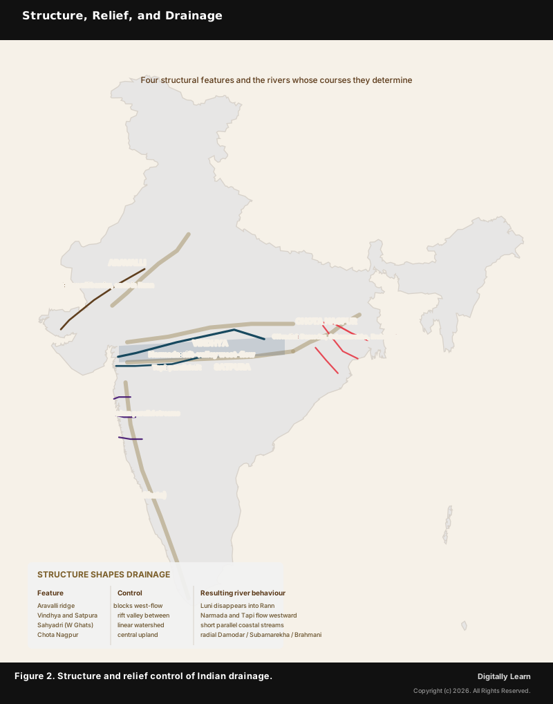
(i) Geological structure: Folds, faults, joints and rift valleys impose strong directional control on river courses. Where bedrock is folded into anticlines and synclines, as in the Himalayan tributaries, main streams run along the synclinal valleys and tributaries cross the anticlinal ridges at right angles, producing a trellis pattern. Where two joint sets cross at right angles in crystalline rock, as in Vindhyan terrain, streams exploit the joint network and produce a rectangular pattern.
Where a long linear rift exists, as along the Narmada, Tapi and Damodar, the river occupies the rift floor regardless of regional slope. Structure is the single most powerful pattern control in mountainous and cratonic India.
(ii) Relief and slope: Steep uniform gradient produces parallel streams, while gentle uniform gradient produces branching dendritic networks. The Western Ghats western face falls from about 1,200-1,500 metres to sea level over only 50-80 kilometres, leaving no room for tributary branching, so dozens of short rivers run parallel to the Arabian Sea. The Indo-Gangetic plain falls under 200 metres over hundreds of kilometres, letting tributaries branch freely into the classic dendritic Ganga network.
Rock Type and Tectonic Forcing: The Deep Geological Drivers
(iii) Rock type and resistance: Uniform resistance produces dendritic networks, while differential resistance produces structurally controlled patterns. Homogeneous bedrock, such as alluvium, uniform granite, or deeply weathered Deccan basalt, gives no preferred direction, so streams take the path of steepest descent into a dendritic form. Differential resistance, such as alternating hard limestone and soft shale on Himalayan flanks or jointed granite on the Vindhyan plateau, opens preferred channels along the weaker rock.
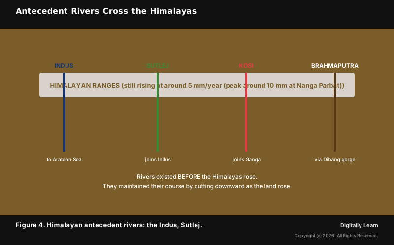
(iv) Tectonic forcing: Active uplift, subsidence and rifting reshape drainage faster than any other process. The Himalayan uplift over about the last 50 million years has driven continuous vertical incision by the Indus, Ganga and Brahmaputra, which cut deep gorges through ridges they predate, producing antecedent drainage (developed in Part 4). The Damodar valley in Jharkhand and West Bengal subsided as a Gondwana down-warp, so the river runs along the rift axis from west to east.
Tectonic forcing also operates on year-scale events. The Kosi avulsion of 18 August 2008 shifted the river about 120 kilometres eastward through an embankment breach after rapid sediment build-up in its actively aggrading foreland, a reminder that channels in tectonically loaded basins can jump course within a single flood season.
Climate and Vegetation as the Surface-Process Modifiers
(v) Climatic conditions: Rainfall regime, vegetation cover and freeze-thaw cycles modulate every other factor. Heavy monsoon rainfall over the Mawsynram-Cherrapunji belt, above 11,000 millimetres a year, produces high stream density and rapid valley incision. The arid Thar Desert, under 250 millimetres a year, produces ephemeral inland streams that fade into the Rann of Kachchh. Vegetation cover slows run-off and lowers sediment yield, while deforestation raises both.
Climate is the slowest-changing factor but the one most open to human-driven shift. The Indian monsoon's intensifying extreme-rainfall events now reshape sediment regimes across the Himalayan and peninsular basins, altering channel form even where structure and relief stay fixed.
| Factor family | Dominant mechanism | Pattern produced | Indian example |
|---|---|---|---|
| Geological structure | Folds, faults, joints, rift valleys | Trellis, rectangular, rift-aligned | Himalayan trellis tributaries; Narmada-Tapi rift |
| Relief and slope | Gradient steepness and uniformity | Parallel on steep uniform slope; dendritic on gentle slope | Western Ghats parallel; Indo-Gangetic dendritic |
| Rock type and resistance | Uniform vs differential erosion resistance | Dendritic on uniform rock; structure-controlled on differential | Deccan basalt dendritic; Vindhyan rectangular |
| Tectonic forcing | Active uplift, subsidence, rifting | Antecedent, superimposed, rift-aligned | Himalayan antecedent gorges; Damodar down-warp |
| Climatic conditions | Rainfall regime, vegetation, freeze-thaw | Modulates stream density and sediment yield | Mawsynram dense network; Thar ephemeral |
Indian Examples Showing the Five Factors at Work
Damodar Down-Warp: A River Set by a Gondwana Rift
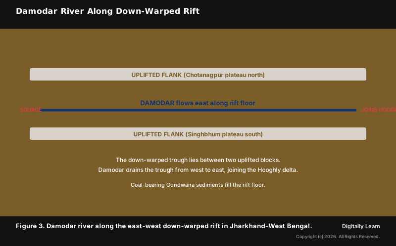
(a) Damodar down-warp: The Damodar rises on the Chotanagpur plateau of Jharkhand and flows east-southeast along a long down-warped trough, joining the Hooghly distributary of the Ganga in West Bengal. The trough lies between the uplifted Chotanagpur plateau to the north and the Singhbhum plateau to the south. The river's east-flowing direction follows the rift floor's orientation, not the regional slope. The rift floor holds Gondwana coal-bearing sediments that powered the Bengal-Bihar industrial belt.
Himalayan Antecedent Rivers Older Than the Mountains
(b) Himalayan antecedent gorges: The Indus, Sutlej, Kosi and Brahmaputra all rise on the Tibetan side north of the main crest, then cross the rising ranges through deep gorges. The rivers existed before the uplift, and as the mountains rose they kept their course by cutting downward at the rate the land rose. The result is antecedent drainage: rivers older than the ridges they cross. The Brahmaputra's Dihang gorge is the deepest of these cuts.
Western Ghats Parallel and Monsoon-Driven Stream Density
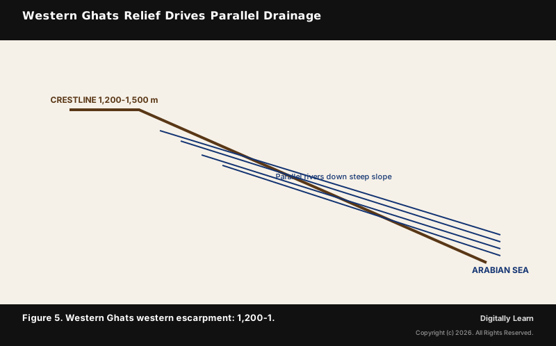
(c) Western Ghats parallel pattern: The western face of the Ghats is one of the clearest cases of relief-driven drainage. The escarpment drops about 1,200-1,500 metres over only 50-80 kilometres, a gradient too steep for tributary networks to grow. Short west-flowing rivers, among them the Sharavati, Mandovi, Periyar, Bharathapuzha and Netravati, run side by side from the crest to the Arabian Sea.
The pattern is so uniform that one Western Ghats river closely resembles another in plan view. Here relief is the dominant control, while rock type and structure stay secondary.
Monsoon rainfall amplifies the structure and relief signals across the Indian drainage map. The southwest monsoon delivers roughly three-quarters of India's annual rainfall in four months, packing the run-off and sediment-transport work into a short window. The Mawsynram-Cherrapunji belt of Meghalaya receives over 11,000 millimetres a year and carries among the densest stream networks in India.
The Thar Desert of western Rajasthan receives under 250 millimetres and supports only ephemeral inland drainage. Climate therefore modulates every drainage pattern across the subcontinent, yet it does not by itself create the geometric form. Structure and relief do that work; rainfall decides how densely and how fast the form is etched.
Contemporary Practice: Factor Mapping in Modern Hydrology
How Factor Analysis Lands in Indian Hydrology Today
Contemporary linkages: Factor analysis now runs in Indian hydrology through GIS-based layer-stack reading. The National Remote Sensing Centre publishes geological-structure, slope, rock-type and rainfall layers as standard products on the Bhuvan portal. The Central Ground Water Board overlays structural and lithological layers to delineate fracture zones for borewell siting under the Atal Bhujal Yojana groundwater framework.
The National Centre for Earth Science Studies at Thiruvananthapuram applies the same factor stack to landslide hazard zonation in the Western Ghats. Part 4 of this series traces how these five factors produced the present Indian drainage through specific evolutionary processes: antecedent drainage, superimposed drainage, river capture, and the long aftermath of Himalayan uplift.
Previous Year UPSC-CSE Questions
Previous Year UPSC-CSE Questions By the end you will be able to draft model answers for the following UPSC questions. Each question carries a collapsible framework showing how to approach it in the exam.
- Prelims 1998Which one of the following east-flowing rivers of India has a rift valley due to down-warping?
How to approach this Prelims question
Approach: Match each river to its structural origin. Damodar: down-warped Gondwana rift between Chotanagpur and Singhbhum plateaus. Mahanadi: dendritic basin draining Chhattisgarh-Odisha. Sone: Vindhya-fed tributary of Ganga. Yamuna: Himalayan-origin tributary of Ganga. Only Damodar has rift origin.
Trap to watch: Mahanadi is sometimes assumed to have rift origin due to its eastward flow, but it is a normal dendritic basin.
Key facts to recall:
- Damodar rises in Chotanagpur plateau and flows east along down-warped rift
- Damodar joins Hooghly distributary of Ganga in West Bengal
- Gondwana coal seams fill the rift floor (foundation of Damodar Valley Corporation industrial belt)
- Damodar Valley Corporation was the first multi-purpose river valley project in independent India
Answer signal: (a) Damodar
- Prelims 2012When you travel in Himalayas, you will see the following :
- Deep gorges
- U-turn river courses
- Parallel mountain ranges
- Steep gradients causing landsliding
Which of the above can be said to be the evidences for Himalayas being young fold mountains?
How to approach this Prelims question
Approach: Each feature evidences young fold-mountain origin. Deep gorges: antecedent rivers cutting downward through rising land. U-turn courses: rivers re-routed around structurally controlled obstacles. Parallel ranges: alternating anticline-syncline pairs of the folded thrust belt. Steep gradients: active uplift exceeds erosion rate, maintaining high relief. All four are diagnostic.
Trap to watch: Some students drop statement 3 (parallel ranges) assuming it is unrelated; in fact, parallel ranges are direct evidence of folded compressional tectonics.
Key facts to recall:
- Himalayas are young fold mountains (formed ~50 Ma; still uplifting at ~5 mm/year (peak around 10 mm at Nanga Parbat))
- Antecedent gorges: rivers older than mountains (Indus, Sutlej, Brahmaputra Dihang gorge)
- Parallel ranges: anticline-syncline pairs of compressional thrust belt
- Active landsliding evidences ongoing uplift outstripping erosion
Answer signal: (d) 1, 2, 3 and 4
- Prelims 2024Consider the following information (Region – Name of the mountain range – Type of mountain):
- Central Asia – Vosges – Fold mountain
- Europe – Alps – Block mountain
- North America – Appalachians – Fold mountain
- South America – Andes – Fold mountain
In how many of the above rows is the given information correctly matched?
How to approach this Prelims question
Approach: Validate each row independently. Row 1: Vosges is in eastern France (Europe), not Central Asia, AND Vosges is an uplifted block mountain, not a fold mountain (TWO errors). Row 2: Alps are in Europe (correct region) but they are fold mountains, not block mountains (TYPE error). Row 3: Appalachians are in North America AND are fold mountains (BOTH correct). Row 4: Andes are in South America AND are fold mountains (BOTH correct). Two rows are fully correct.
Trap to watch: All four mountain TYPES sound plausible at glance; the trap is in mismatched region (Vosges-Central Asia) and mismatched type (Alps-block).
Key facts to recall:
- Vosges: eastern France, block mountain (rift shoulder of Rhine graben)
- Alps: Europe, fold mountain (Alpine orogeny)
- Appalachians: eastern North America, fold mountain (Paleozoic)
- Andes: South America, fold mountain (Pacific subduction)
Answer signal: (b) Only two
- UPSC Mains 2021 GS-IDifferentiate the causes of landslides in the Himalayan region and Western Ghats.
How to structure the answer in the exam
Introduction: Open with the factor-family framework: landslides arise from structure, relief, rock resistance, tectonic forcing, and climate; the relative weight differs across the two regions.
Conclusion: Close with the tectonic-forcing signal as the dominant differentiator: Himalayan landslides are triggered by tectonic stress and monsoon, Western Ghats by monsoon-driven saturation alone.
Sources
- NCERT Class 11 India Physical Environment, Chapter 3 (Drainage System), pp 27-37
- Geological Survey of India: tectonic atlas and Gondwana coal-bearing basins
- Central Water Commission (CWC) basin morphometry and flood-routing
- Central Ground Water Board (CGWB) fracture-zone aquifer mapping
- National Remote Sensing Centre (ISRO) Bhuvan portal
- National Centre for Earth Science Studies, Thiruvananthapuram (NCESS)
- Damodar Valley Corporation (DVC)
- Ministry of Earth Sciences (MoES) Climate Change Assessment
- Wikipedia: Damodar River
- Wikipedia: Antecedent drainage stream
Disclaimer
This article is a study aid grounded in NCERT and the official sources cited. Tectonic and structural classifications follow Geological Survey of India convention; readers cross-checking specific Indian examples should consult GSI publications for precise structural boundaries.