
Overview
Mechanism, plates and seismic waves
The science of fault rupture, plate boundaries, seismic waves, and the magnitude scales that measure every earthquake.
Previous Year UPSC-CSE Questions By the end you will be able to draft model answers for the following UPSC questions. Each question carries a collapsible framework showing how to approach it in the exam.
- UPSC Mains 2014 GS-IWhy are the world's fold mountain systems located along the margins of continents? Bring out the association between the global distribution of fold mountains and the earthquakes and volcanoes.
How to structure the answer in the exam
Introduction: Fold mountain systems form where compressional stress folds and uplifts crustal rocks. The compression originates at convergent plate boundaries where two lithospheric plates collide. Continental margins host the bulk of fold mountains because continental crust resists subduction.
Body (sub-themes to develop):
- Convergent boundary mechanism: oceanic-continental subduction (Andes, Cascades) or continent-continent collision (Himalaya, Alps) compresses crust, generating fold-and-thrust belts at continental margins.
- Pacific Ring of Fire: ~90 per cent of global earthquakes plus most active volcanoes; traces subduction zones around the Pacific from Andes through Aleutian, Japan, Indonesia.
- Alpine-Himalayan belt: about 17 per cent of the world's largest earthquakes; extends from Mediterranean through Iran, Hindu Kush, Himalaya, into Indonesia.
- Spatial coincidence explanation: subduction zones generate fold mountains (compressive uplift), large earthquakes (thrust faulting), and volcanoes (slab dehydration triggering mantle melt). All three phenomena share the convergent-margin tectonic setting.
- Indian context: Himalayan fold-and-thrust system is the world's largest active continental collision; coincides with India's primary seismic belt (BIS Zones IV and V along the Himalayan front).
Conclusion: Fold mountains, earthquakes, and volcanoes share a single tectonic cause: convergent plate-boundary stress. Their global distribution is therefore not coincidental but a direct cartographic record of plate-tectonic geometry, with the Pacific Ring of Fire and the Alpine-Himalayan belt as the two dominant expressions.
- UPSC Prelims 2004 General StudiesConsider the following geological phenomena:
- Development of a fault
- Movement along a fault
- Impact produced by a volcanic eruption
- Folding of rocks
Which of the above cause earthquakes?
How to approach this Prelims question
Approach: Evaluate each of the four phenomena against the question of whether it is a direct cause of earthquakes. (1) fault development = brittle rock failure releasing seismic energy: YES; (2) fault movement = primary tectonic-earthquake mechanism: YES; (3) volcanic eruption = produces volcano-tectonic earthquakes through magma movement: YES; (4) folding of rocks = slow ductile deformation over geological time: NO, not a direct discrete-event cause. The UPSC official key takes (a) 1, 2 and 3.
Trap to watch: Statement 4 (folding of rocks) is the trap. Folding occurs under the same compressional stress regime that ultimately produces faulting at convergent plate boundaries, but folding itself is the ductile response playing out over millions of years; it does not cause discrete seismic events. A student who treats 'all four are related to convergent stress' as proof of 'all four cause earthquakes' will incorrectly choose (d).
Key facts to recall:
- Fault rupture: brittle failure of rock; the primary tectonic-earthquake mechanism (about 95 per cent of seismic energy release).
- Volcano-tectonic earthquakes: produced by magma movement, gas overpressure, and ground deformation around active volcanoes.
- Folding vs faulting: at convergent boundaries, compressional stress produces folding (ductile, slow) AND faulting (brittle, sudden); only faulting generates discrete earthquakes.
- UPSC convention: the 2004 official key excludes folding as an earthquake cause, treating it as a distinct geological process.
Answer signal: (a) 1, 2 and 3
- UPSC Prelims 2006 General StudiesConsider the following statements:
- The Richter scale is a logarithmic scale and so an increase of 1 magnitude unit represents a factor of 10 times in amplitude.
- Each integer reading of the Richter scale has an energy 100 times that of the previous integer reading.
Which of the statements given above is/are correct?
How to approach this Prelims question
Approach: Statement 1 is the well-known logarithmic-amplitude property of the Richter scale and is widely tested. Statement 2 introduces a numerical trap by stating 100-fold energy increase per magnitude unit; this is incorrect. The correct energy multiplier is approximately 31.6 per magnitude unit (or about 32 in round numbers).
Trap to watch: The 100-fold figure in Statement 2 is the squared version of the 10-fold amplitude factor. A student who confuses amplitude scaling with energy scaling will pick (c) Both 1 and 2. The correct relationship: amplitude scales as 10 per unit; energy scales as 10 to the power of 1.5 per unit, which is approximately 32.
Key facts to recall:
- Richter scale logarithm: 1 magnitude unit = 10 times amplitude.
- Energy multiplier: 1 magnitude unit = approximately 32 times energy release (more precisely, 10^1.5 ≈ 31.6).
- Moment-magnitude (Mw): modern international standard since 1979; replaces Richter (ML) for events above M7 because Richter saturates.
- Magnitude vs intensity: magnitude is one number per event; intensity (Mercalli, MSK) varies with location.
Answer signal: (a) 1 only
An earthquake is the sudden release of elastic strain energy accumulated in the Earth's crust along a fault, radiating outward as seismic waves that produce ground shaking. The release point at depth is called the focus or hypocentre; the surface point directly above is the epicentre. Earthquakes are classified by focal depth as shallow (less than 70 km), intermediate (70 to 300 km), and deep (300 to 700 km). They are also classified by causative mechanism: tectonic (the dominant class, driven by plate motion), volcanic, collapse, and induced (reservoir loading, fluid injection). The Earth registers several million earthquakes annually; most are too small to be felt, and only the larger events have policy consequences.
Background and Historical Context
Why it matters: India sits on the northward-moving Indian Plate, which collides with the Eurasian Plate at approximately 5 centimetres per year. The collision drives the Himalayan orogeny and generates the country's primary seismic belt. Approximately 59 per cent of India's land area lies in moderate-to-high seismic hazard zones (Bureau of Indian Standards Zones III, IV, and V). UPSC Prelims has tested earthquake mechanism, magnitude scales, and plate-tectonic context in 2001, 2004, 2006, and 2021. UPSC Mains GS-I covers geomorphology and plate-tectonic geography; GS-III covers disaster management and the earthquake-resilience policy stack.
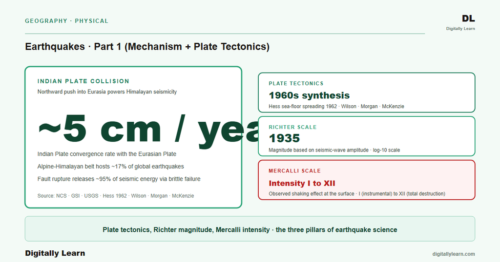
The science of earthquakes rests on three foundations. The first is plate tectonics, the unifying theory of solid-earth geology proposed in coherent form by Tuzo Wilson, Jason Morgan, and Dan McKenzie in the 1960s. The second is the elastic-rebound theory, formulated by Harry Fielding Reid in 1910 after studying the 1906 San Francisco earthquake, which explains why faults store and suddenly release strain energy. The third is seismology, the study of seismic waves through the Earth, which since the work of Richard Oldham, Beno Gutenberg, and Inge Lehmann has revealed the layered structure of the Earth's interior.
Part 1 of this series covers the science foundation. Part 2 maps it to India: the BIS IS 1893 seismic zoning, the roster of historical Indian earthquakes from 1819 Kutch to 2015 Nepal, and the Himalayan seismic-gap hypothesis. Part 3 closes the cluster with the policy framework: NDMA Earthquake Management Guidelines, the Disaster Management Act 2005, India's implementation of the Sendai Framework, and the earthquake-resistant construction code family (IS 1893, IS 13920, IS 4326, IS 13828).
Introduction: Definition, Focus and Epicentre, Elastic Rebound, and Focal-Depth Classification
Definition and terminology
An earthquake is the sudden release of elastic strain energy from the Earth's crust along a fault. The released energy radiates outward as seismic waves and produces the ground shaking that humans perceive. Earthquakes occur in the brittle outer layers of the Earth, primarily within the crust and upper mantle. The most common causative mechanism is tectonic, driven by the relative motion of lithospheric plates.
Three terms define the spatial description of every earthquake. The focus (also called the hypocentre) is the point at depth where the fault rupture initiates and strain energy releases. The epicentre is the point on the Earth's surface directly above the focus. The focal depth is the vertical distance from the surface to the focus. Earthquakes are conventionally classified by focal depth into three categories: shallow (less than 70 kilometres), intermediate (70 to 300 kilometres), and deep (300 to 700 kilometres). Shallow earthquakes account for the majority of seismic energy release and produce the most surface destruction.
Elastic-rebound theory
Harry Fielding Reid formulated the elastic-rebound theory in 1910 after surveying the surface ruptures of the 1906 San Francisco earthquake. The theory explains why faults store energy and release it episodically. Tectonic forces deform the rocks adjacent to a locked fault elastically over years to centuries. The accumulated elastic strain energy grows until it exceeds the frictional strength holding the fault locked. At that threshold the fault ruptures, the rocks on either side spring back toward their unstressed configuration, and the released strain energy radiates outward as seismic waves.
The cycle then repeats. The fault locks again after rupture, strain begins to accumulate, and the next event becomes inevitable on a timescale set by the rate of plate motion and the locked-fault area. This recurrence-interval framing is the basis for the seismic-gap hypothesis (Part 2): segments of plate boundaries that have not ruptured recently are accumulating strain and represent the most probable locations of future large events.
- Shallow earthquakes (Under 70 km depth): bulk of seismic energy release; greatest surface damage potential; most Indian events including Bhuj 2001, Kashmir 2005, Nepal 2015.
- Intermediate-focus earthquakes (70-300 Km): typically along subduction zones; deeper Wadati-Benioff zone; some Hindu Kush events.
- Deep-focus earthquakes (300-700 Km): exclusive to subduction zones where descending slabs reach the lower mantle; less damaging at surface but help constrain mantle structure.
Plate Tectonics: the Macro Engine driving Indian Plate Motion, Himalayan Collision, and Global Seismic Belts
Plate-tectonic context
What is the significance of plate-tectonic context for earthquakes? Approximately 95 per cent of the world's seismic energy releases along plate boundaries. The remaining 5 per cent occurs in stable continental interiors as intraplate events. Understanding which plate boundary a region sits on therefore predicts its dominant earthquake style, magnitude potential, and recurrence behaviour. India sits on the northward-moving Indian Plate; its seismic profile cannot be read without first establishing this tectonic context.
The Earth's lithosphere is divided into about 15 major plates and a larger number of smaller plates. Each plate is rigid relative to its interior but deforms continuously at its margins. Plate boundaries come in three principal types defined by relative motion: divergent (plates moving apart), convergent (plates moving together), and transform (plates sliding past each other horizontally). Each boundary type produces a characteristic earthquake signature.
The three plate-boundary types
Divergent boundaries occur where two plates pull apart and new oceanic lithosphere forms by sea-floor spreading. Mid-ocean ridges (Mid-Atlantic, East Pacific Rise, Carlsberg Ridge in the Indian Ocean) are the dominant divergent features. Earthquakes here are shallow and typically moderate in magnitude, rarely exceeding M7. The East African Rift represents continental rifting, the early stage of new-ocean creation.
Convergent boundaries produce the largest earthquakes on Earth. Two sub-types exist. Subduction occurs where oceanic lithosphere descends beneath continental or other oceanic lithosphere (Pacific Ring of Fire, Japan, Indonesia, Andes). Subduction zones generate the world's largest earthquakes, including the 1960 Chile M9.5 and 2011 Japan M9.0 events. Collision occurs where two continental plates meet (the Indian Plate northward thrust into the Eurasian Plate). Collision generates the Himalayan thrust system; the largest historical Himalayan events are around M8.0-8.5.
Transform boundaries occur where two plates slide horizontally past each other along a fault. The San Andreas Fault in California is the best-known example. Transform-boundary earthquakes are typically shallow and can reach moderate-to-large magnitudes (1906 San Francisco M7.9). The North Anatolian Fault in Turkey produced the 1999 Izmit M7.6 event.
Indian Plate and global seismic belts
The Indian Plate separated from Gondwanaland in the Mesozoic and migrated northward across the Tethys Ocean. The plate collided with the Eurasian Plate approximately 50 million years ago, initiating the Himalayan orogeny. The collision continues today: GPS geodesy measures India's northward motion at approximately 5 centimetres per year, with about 2 centimetres per year accommodated by Himalayan shortening and the remainder distributed across the Tibetan Plateau and other features.
The world's earthquakes concentrate in two major belts and a few minor systems. The Pacific Ring of Fire accounts for approximately 90 per cent of global earthquakes; it traces the subduction zones around the Pacific Plate margins from Chile through Aleutian, Japan, Philippines, Indonesia, and New Zealand. The Alpine-Himalayan belt (the Alpide belt) accounts for approximately 17 per cent of the world's largest earthquakes; it extends from the Mediterranean through the Caucasus, the Middle East, the Hindu Kush, the Himalaya, and into Indonesia. The mid-ocean-ridge system accounts for most of the remainder, generating frequent but smaller earthquakes along divergent boundaries.
Fault Mechanics: the Micro Engine Producing Strike-Slip, Normal, and Reverse Faults across the Indian Subcontinent
Distinguishing features of fault types
A fault is a fracture or zone of fractures in the Earth's crust along which rocks on opposite sides have moved relative to each other. Three principal fault types arise from the three principal stress regimes. Each produces a distinctive earthquake style and characteristic surface rupture pattern.
- Strike-slip faults: Rocks move horizontally past each other along a near-vertical fault plane. The San Andreas Fault in California is the best-known example; the North Anatolian Fault in Turkey is another. Strike-slip faults can generate large events (1906 San Francisco M7.9, 1999 Izmit M7.6) but rarely produce vertical surface offset.
- Normal faults: Arise under extensional (tensional) stress; the hanging-wall block slides down relative to the footwall. Normal faults dominate divergent boundaries like the East African Rift and the Basin and Range Province of the western United States. India has minor normal-faulting in the Cambay Basin and the Narmada-Son lineament.
- Reverse and thrust faults: Arise under compressional stress; the hanging-wall block moves up relative to the footwall. Thrust faults are reverse faults with shallow dip (less than 45 degrees). The Main Himalayan Thrust, the Main Central Thrust, and the Main Boundary Thrust are the dominant structures of the Himalayan front; all are thrust faults driven by the India-Eurasia collision.
The Himalayan thrust system
The Himalayan front is the world's largest active thrust-fault system. Three major thrust faults divide the orogen into structural zones from north to south. The Main Central Thrust (MCT) separates the Higher Himalaya from the Lesser Himalaya. The Main Boundary Thrust (MBT) separates the Lesser Himalaya from the Sub-Himalaya (Siwalik foothills). The Main Frontal Thrust (MFT) separates the Siwaliks from the Indo-Gangetic plain and represents the active deformation front today.
All three thrusts root into a single basal detachment called the Main Himalayan Thrust (MHT). The MHT carries the bulk of present-day convergence and produces the largest Himalayan earthquakes. The 1934 Bihar-Nepal M8.0, the 2005 Kashmir M7.6, and the 2015 Nepal Gorkha M7.8 events all ruptured segments of the MHT. The fault is partially locked along its central segment; the seismic-gap hypothesis (Part 2) treats this locked segment as the most probable source of the next Himalayan great earthquake.
Seismic Waves: P-Waves, S-Waves, and Surface Waves carrying Information about the Earth's Interior
Observable wave types and their signatures
Seismic energy released by fault rupture propagates outward in three principal wave types. Each travels at a different speed and through different media; the order of arrival at any seismograph follows from these properties.
- P-waves (primary, compressional): Longitudinal waves in which particle motion is parallel to the direction of wave propagation. P-waves travel through solids, liquids, and gases. Velocity in the upper crust is approximately 5 to 7 kilometres per second; in the upper mantle 8 kilometres per second; in the outer core (liquid) 8 to 10 kilometres per second; in the inner core 11 kilometres per second. P-waves arrive first at every seismograph and are the fastest of the three types.
- S-waves (secondary, shear): Transverse waves in which particle motion is perpendicular to the direction of propagation. S-waves travel through solids only because liquids cannot support shear stress. Velocity in the upper crust is approximately 3 to 4 kilometres per second. S-waves arrive at a seismograph after the P-waves; the time gap between P and S arrival increases with distance and is used to estimate epicentral distance.
- Surface waves (Love and Rayleigh): Trapped at the Earth’s surface and travel along it rather than through the interior. Love waves are horizontally polarised shear waves; Rayleigh waves involve a retrograde elliptical particle motion combining vertical and horizontal components. Surface waves are slower than both P and S body waves but carry the largest amplitude at long distances. They produce the bulk of ground shaking that damages buildings.
Earth interior revealed by wave behaviour
The behaviour of seismic waves passing through the Earth provides the strongest evidence for the layered structure of the planet. Inge Lehmann in 1936 used P-wave behaviour to discover the inner core. Beno Gutenberg earlier identified the mantle-core boundary at approximately 2,890 kilometres depth from the S-wave shadow zone. Andrija Mohorovicic in 1909 found the crust-mantle boundary (the Moho) from P-wave velocity changes.
The S-wave shadow zone is the most direct evidence for the liquid outer core. S-waves cannot propagate through liquids, so seismographs located beyond approximately 104 degrees of arc-distance from an earthquake receive no direct S-wave signal at all. The absence reveals that a layer at depth blocks the shear waves: that layer is the liquid outer core. The P-wave shadow zone is a narrower band, roughly 104 to 140 degrees, caused by refraction of P-waves where they enter and exit the liquid outer core rather than by total absorption; P-waves re-emerge beyond 140 degrees. These wave-behaviour anomalies, mapped over millions of recordings, constrain the depth and physical state of every major Earth-interior layer.
Measurement: Magnitude Scales (Richter, Moment Magnitude) vs Intensity Scales (Mercalli, MSK)
Magnitude scales
Magnitude measures the energy released by an earthquake at its source. It is a single number per event, computed from seismograph recordings, and does not depend on where the seismograph is located (with corrections for distance and site effects). Magnitude scales are logarithmic: each whole-number increase represents a tenfold increase in amplitude and approximately a 32-fold increase in energy release.
Charles Richter introduced the local-magnitude scale (ML) in 1935 based on the maximum amplitude of seismograph traces in southern California. The Richter scale works well for shallow, nearby earthquakes but saturates above approximately M7. Modern seismology uses the moment-magnitude scale (Mw), introduced by Tom Hanks and Hiroo Kanamori in 1979, which is computed from the seismic moment (the product of fault area, slip, and rigidity). Mw does not saturate and is therefore the international standard for events larger than M7.
Two intermediate scales remain in operational use. The body-wave magnitude (mb) uses the P-wave amplitude at distant stations; useful for deep earthquakes. The surface-wave magnitude (Ms) uses the Rayleigh-wave amplitude at long periods; commonly cited in older catalogues. The four magnitude scales agree closely for moderate events (around M5-6) but diverge for the smallest and largest events.
Intensity scales
Intensity measures the strength of ground shaking and the damage produced at a specific location. Intensity varies with distance from the epicentre, focal depth, local geology, and building stock. A single earthquake therefore has one magnitude but many intensities, one for every location surveyed.
The Modified Mercalli Intensity (MMI) scale uses Roman numerals from I (not felt) to XII (total destruction). MMI is the dominant intensity scale in the United States. The Medvedev-Sponheuer-Karnik (MSK) scale, similar in structure with Roman numerals I to XII, is the operational intensity scale used by India's National Center for Seismology. Macro-seismic intensity surveys conducted after major Indian earthquakes (Bhuj 2001, Kashmir 2005) employ the MSK scale for damage assessment.
| Scale | Magnitude type | Range | Operational status |
|---|---|---|---|
| Richter (ML) | Magnitude | Open; saturates above M7 | Historical; superseded by Mw above M7 |
| Body-wave (mb) | Magnitude | Open; useful for deep events | Active for monitoring catalogues |
| Surface-wave (Ms) | Magnitude | Open; saturates above M8 | Active for long-period events |
| Moment magnitude (Mw) | Magnitude | Open; no saturation | International standard since 1979 |
| Mercalli (MMI) | Intensity | I to XII (Roman numerals) | Standard in US; widely cited internationally |
| MSK | Intensity | I to XII (Roman numerals) | Operational in India (NCS) |
Contemporary Linkages: NCS Monitoring, GPS Geodesy on Himalayan Strain, Mission Mausam, and the Pending Great-Earthquake Research Frontier
Contemporary monitoring and the research frontier
Contemporary linkages: India's earthquake science rests on three institutional pillars in 2026. The National Center for Seismology (NCS Delhi), under the Ministry of Earth Sciences, operates 161 seismic stations nationwide as of 2024. The NCS issues real-time earthquake bulletins within 7 to 10 minutes of every M3.5 or larger event in or near India and feeds magnitude and location data to NDMA and state disaster management authorities.
The Institute of Seismological Research (ISR) Gandhinagar, Gujarat, was established after the 2001 Bhuj earthquake and operates a dense regional network in western India. ISR coordinates with NCS on microzonation, instrumental records, and post-earthquake response. The Indian Network for Geodynamics (INGN) operates a GPS-geodesy network that measures strain accumulation along the Himalayan front in near-real-time. INGN measurements feed the seismic-gap analysis that frames the central Himalaya's pending-great-earthquake hypothesis.
The contemporary research frontier centres on the pending great Himalayan earthquake. GPS-measured strain accumulation along the central Himalayan seismic gap (the segment between the 1905 Kangra and 1934 Bihar-Nepal ruptures) implies a strain-budget deficit consistent with a future M8.0 or larger event. The recurrence interval inferred from palaeo-seismology is several hundred years; the precise timing is not knowable. The Mission Mausam framework announced by MoES in September 2024 integrates atmospheric and seismic monitoring; the BhooKamp app launched in 2021 delivers earthquake alerts to citizens; the National Earthquake Early Warning System is under build-out. Part 2 of this series carries the science foundation established here into India's seismic-zone mapping and the historical earthquake roster; Part 3 closes the cluster with the NDMA disaster-management framework.
Prelims MCQ practice
Each question below tests one specific concept on the topic. Click to reveal the answer and a full option-wise explanation.
Q1. Consider the following statements about plate-boundary types:
- Divergent boundaries form new oceanic lithosphere by sea-floor spreading and typically produce shallow, moderate earthquakes.
- Convergent boundaries include both subduction zones and continental collision zones, and produce the largest earthquakes on Earth.
- Transform boundaries are vertical faults where one plate descends beneath another at right angles.
Which of the statements given above is/are correct?
- 1 only
- 1 and 2 only
- 2 and 3 only
- 1, 2 and 3
Show answer and explanation
Answer: 1 and 2 only
Explanation.
Statements 1 and 2 are correct. Divergent boundaries (mid-ocean ridges) produce shallow, moderate earthquakes through sea-floor spreading. Convergent boundaries include subduction (the world's largest earthquakes like 1960 Chile M9.5) and continental collision (Himalayan thrust system). Statement 3 is incorrect: transform boundaries are characterised by HORIZONTAL motion where plates slide past each other along near-vertical faults (San Andreas, North Anatolian), not vertical descent. The correct answer is (b) 1 and 2 only.
Q2. Consider the following statements about the Indian Plate:
- It separated from Gondwanaland in the Mesozoic and migrated northward across the Tethys Ocean.
- It currently moves northward at approximately 5 centimetres per year, measured by GPS geodesy.
- Its collision with the Eurasian Plate began approximately 50 million years ago and continues today.
Which of the statements given above is/are correct?
- 1 only
- 2 and 3 only
- 1 and 3 only
- 1, 2 and 3
Show answer and explanation
Answer: 1, 2 and 3
Explanation.
All three statements are correct. The Indian Plate's Mesozoic separation from Gondwanaland, its current ~5 cm/year northward motion (measured by GPS geodesy), and its ~50-million-year-old ongoing collision with the Eurasian Plate are all standard plate-tectonic facts. The Himalayan orogeny is the direct expression of this collision. The correct answer is (d) 1, 2 and 3.
Q3. Consider the following statements about seismic waves:
- P-waves are compressional, travel through solids and liquids, and arrive first at every seismograph.
- S-waves are shear waves and travel through solids only.
- Surface waves are the fastest of the three wave types and carry the smallest amplitude.
Which of the statements given above is/are correct?
- 1 only
- 1 and 2 only
- 1 and 3 only
- 1, 2 and 3
Show answer and explanation
Answer: 1 and 2 only
Explanation.
Statements 1 and 2 are correct: P-waves are compressional, travel through any medium, and arrive first; S-waves are shear waves restricted to solid media. Statement 3 is INCORRECT on both counts: surface waves are the SLOWEST of the three principal wave types AND carry the LARGEST amplitude at long distances, which is why they produce the bulk of building damage. The correct answer is (b) 1 and 2 only.
Q4. Consider the following statements:
- Magnitude measures the energy released by an earthquake at its source and is a single number per event.
- Intensity measures the strength of ground shaking and damage at a specific location, and varies with distance from the epicentre.
- Both magnitude and intensity scales are linear, with each unit increase representing equal energy or damage steps.
Which of the statements given above is/are correct?
- 1 only
- 1 and 2 only
- 2 and 3 only
- 1, 2 and 3
Show answer and explanation
Answer: 1 and 2 only
Explanation.
Statements 1 and 2 are correct: magnitude is a single number per event based on source energy; intensity varies with location, building stock, and local geology. Statement 3 is INCORRECT: magnitude scales are LOGARITHMIC (each unit = 10x amplitude, ~32x energy); intensity scales are categorical/ordinal Roman numerals from I to XII. Neither is linear. The correct answer is (b) 1 and 2 only.
Q5. Match the Himalayan thrust faults with their structural role:
- Main Central Thrust (MCT): separates Higher Himalaya from Lesser Himalaya.
- Main Boundary Thrust (MBT): separates Lesser Himalaya from Sub-Himalaya (Siwaliks).
- Main Frontal Thrust (MFT): represents the active deformation front today, separating Siwaliks from Indo-Gangetic plain.
Which of the matchings given above are correct?
- 1 only
- 1 and 2 only
- 2 and 3 only
- 1, 2 and 3
Show answer and explanation
Answer: 1, 2 and 3
Explanation.
All three matchings are correct per standard Himalayan structural geology. MCT, MBT, and MFT are the three principal south-vergent thrust faults of the Himalayan orogen, separating the four structural zones (Higher Himalaya, Lesser Himalaya, Sub-Himalaya/Siwaliks, Indo-Gangetic plain). All three root into the Main Himalayan Thrust (MHT) detachment at depth. The correct answer is (d) 1, 2 and 3.
Q6. Consider the following statements about the elastic-rebound theory:
- It was proposed by Harry Fielding Reid after the 1906 San Francisco earthquake.
- It explains how faults store strain energy during the inter-seismic period and release it suddenly when rupture occurs.
- It predicts that seismic-gap segments of plate boundaries that have not ruptured recently are accumulating strain and are likely future-earthquake locations.
Which of the statements given above is/are correct?
- 1 only
- 1 and 2 only
- 1, 2 and 3
- 2 and 3 only
Show answer and explanation
Answer: 1, 2 and 3
Explanation.
All three statements are correct. Reid proposed elastic-rebound after the 1906 San Francisco earthquake; the theory explains the inter-seismic strain-accumulation cycle and the sudden release at rupture; the seismic-gap hypothesis (linking unfilled boundary segments to future earthquake locations) is a direct corollary applied to the central Himalayan gap, Kashmir gap, and Assam-Myanmar gap among others. The correct answer is (c) 1, 2 and 3.
Sources and references
- National Center for Seismology, Ministry of Earth Sciences: official portal
- Ministry of Earth Sciences: institutional overview and Mission Mausam
- National Disaster Management Authority: earthquake risk page
- Bureau of Indian Standards: IS 1893 earthquake-resistant design
- Geological Survey of India: seismotectonic atlas
- Indian Meteorological Department: official portal
- Press Information Bureau: BhooKamp app launch 2021
- Wikipedia: Earthquake (overview)
- Wikipedia: Plate tectonics
- Wikipedia: Seismic wave
- Wikipedia: Richter scale
- Wikipedia: Moment magnitude scale
- Wikipedia: Modified Mercalli intensity scale
- Wikipedia: Elastic-rebound theory
- Wikipedia: Indian Plate
Disclaimer and notes
This article is compiled from the reference materials listed in the Sources section. It is an explainer for UPSC preparation and is not a substitute for primary documents (NCERTs, GoI ministry releases, IMD bulletins, RBI / CEA / MoEFCC publications, and Standing-Committee reports).


