


Overview
Air masses, fronts and polar front theory
How mid-latitude cyclones form on the polar front, grow, occlude and die, and how they reach India as western disturbances.
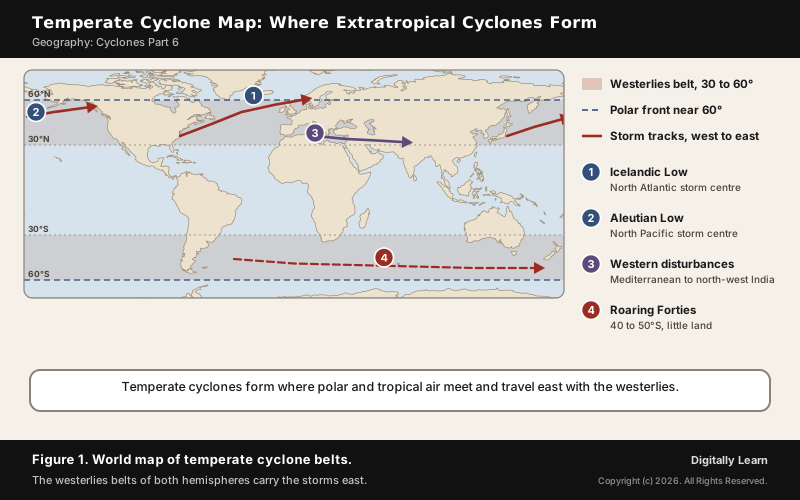
A temperate cyclone, also called an extratropical cyclone or mid-latitude cyclone, is a low-pressure system that forms beyond the tropics, usually between 30 and 60 degrees latitude, where cold polar air meets warm tropical air along the polar front. Its winds circle the low anticlockwise in the northern hemisphere, it carries a warm front and a cold front, and it moves from west to east with the westerlies, bringing rain, snow and sudden changes of weather.
Temperate or Extratropical Cyclone: Meaning, Winds and Where It Forms
What Is a Temperate Cyclone?
A temperate cyclone is a low-pressure weather system of the middle and high latitudes, beyond the tropics, and for that reason it is also called a middle latitude or extra tropical cyclone. Forecasters often call one simply a depression or a low. Unlike a tropical cyclone, it brings rapid changes of temperature along broad lines called weather fronts, which radiate from its centre.
Like every cyclone, it is a low with air converging towards the centre and rising. The rising air makes clouds and precipitation, so a passing temperate cyclone can bring anything from light showers to blizzards, hail, thunderstorms and even tornadoes. Along with the anticyclones between them, these lows drive the weather over much of the middle latitudes.
- Cyclone: Low pressure at the centre; winds turn anticlockwise in the northern hemisphere and clockwise in the southern.
- Anticyclone: High pressure at the centre; winds turn clockwise in the northern hemisphere and anticlockwise in the southern.
Westerlies, the Ferrel Cell and the Polar Front
Temperate cyclones belong to the belt of the westerlies, the prevailing winds that blow from west to east between 30 and 60 degrees latitude. In the general circulation of the atmosphere, the middle latitudes hold the Ferrel cell: warm air from the subtropical high rises and cold air from the poles sinks, and at the surface the winds are the westerlies. These winds steer the cyclones, which is why temperate cyclones travel from west to east.
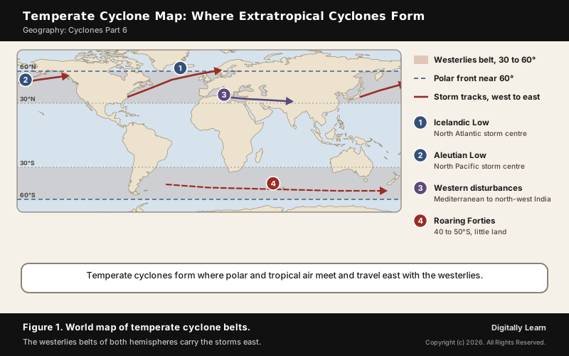
The storms form along the polar front, the boundary between the polar cell and the Ferrel cell near 60 degrees latitude in both hemispheres, where cold polar air meets warm tropical air across a sharp temperature gradient. In winter the polar front shifts towards the equator, and the strongest, hurricane-force temperate cyclones are most likely over the northern Atlantic and Pacific in December and January.
- Southern hemisphere: The westerlies are strongest where land is absent, because land bends the flow and slows it; the Roaring Forties blow between 40 and 50 degrees S, and the Furious Fifties and Shrieking Sixties lie further south.
- Northern hemisphere: The winds blow mostly from the south-west; the large continents break up the flow.
- Coriolis force: It depends on latitude, not on the hemisphere; it is maximum at the poles and absent at the equator, the same in both halves of the globe.
Air Masses and Fronts: How Temperate Cyclones Get Their Energy
Air Masses: Source Regions and Types
When air stays over a uniform surface for long enough, it takes on the temperature and moisture of that surface. A large body of air with little horizontal variation in temperature and moisture is an air mass, and the uniform surface where it forms is its source region. There are five major source regions, and each gives one type of air mass.
| Air mass | Source region and nature |
|---|---|
| mT, maritime tropical | Warm tropical and subtropical oceans; warm and moist |
| cT, continental tropical | Subtropical hot deserts; hot and dry |
| mP, maritime polar | Cold high-latitude oceans; cold and moist |
| cP, continental polar | Snow-covered continents in high latitudes; cold and very dry |
| cA, continental arctic | Ice-covered Arctic and Antarctica; very cold and dry |
The letters follow the Bergeron classification: c for continental and dry, m for maritime and moist, then T, P or A for tropical, polar or arctic. An air mass changes as it travels. Arctic air moving over a warmer ocean picks up warmth and moisture and becomes maritime polar; the same polar air moving over land stays dry and becomes continental polar.
Air Masses in Macro-Climate: Fronts, Cyclones and Heat Transport
Air masses matter to climate because they carry the character of one region into another. Where two of them meet, the colder, denser air undercuts the warmer air and forces it to rise, and the rising air makes cloud and rain. That contrast is the energy source of a temperate cyclone: it forms along a zone of temperature difference, which is why it is called a baroclinic cyclone.
On the planetary scale, these cyclones move heat towards the poles. The transfer of heat from low to high latitudes maintains the general circulation, and the dynamics of the polar front and its cyclones, as Jacob Bjerknes and Halvor Solberg showed in 1922, are the main mechanism of north-south heat transport. Each cyclone turns part of the temperature gradient between pole and equator into wind and, in doing so, reduces that gradient.
- Winter in India: Dry continental air blowing out of the high-pressure centre over Central Asia reaches India as a dry continental air mass and gives the clear, cold weather of the season.
- Summer in India: The maritime tropical air of the southern hemisphere crosses the equator and rushes to the low over India as the south-west monsoon; see the Indian monsoon mechanism.
- The middle latitudes: The meeting of polar and tropical air masses produces the fronts, cyclones and changeable weather of Europe, North America and East Asia.
Types of Fronts: Warm, Cold, Stationary and Occluded
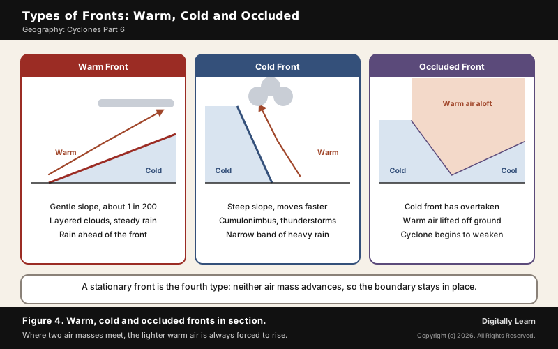
When two different air masses meet, the boundary between them is a front, and the process that forms it is frontogenesis. Fronts occur in the middle latitudes, have steep gradients of temperature and pressure, and bring abrupt changes of temperature as they pass, with rising air, cloud and rain.
| Front | How it forms and the weather it brings |
|---|---|
| Warm front | Warm air moves towards cold air and glides up over it along a gentle slope of about 1 in 200; high cirrus clouds come first, then layered clouds and steady, widespread rain ahead of the front |
| Cold front | Cold air moves towards warm air and pushes under it along a steep slope, moving faster; cumulonimbus clouds give a narrow band of showers and thunderstorms and a sharp fall in temperature |
| Stationary front | Neither air mass advances, so the boundary stays in place for hours or days and cloud and rain can persist over the same area |
| Occluded front | The cold front overtakes the warm front and the warm air is lifted off the ground; the cyclone starts to weaken |
On a weather map a cold front is a blue line with triangles and a warm front a red line with semicircles, both pointing the way the front moves. Occlusions come in two kinds: in a cold occlusion the overtaking air is colder than the air ahead and ploughs under it, and in a warm occlusion it is warmer and rides over it.
Polar Front Theory and the Stages of Temperate Cyclone
Polar Front Theory of Bjerknes and Solberg
The polar front theory was given by Jacob Bjerknes and his colleagues of the Bergen School of Meteorology in Norway. The school was founded in 1917 by his father, Vilhelm Bjerknes, and its team, including Halvor Solberg and Tor Bergeron, built the theory from a network of weather stations along the Norwegian coast during the First World War.
The theory found that air flows into a cyclone along two lines of convergence: one ahead of the low, later called the warm front, and one trailing behind it, later called the cold front. Clouds and rain gather along these lines. The idea of fronts led in turn to the idea of air masses, and the 1922 paper of Bjerknes and Solberg set out the life cycle of the cyclone that is still taught as the Norwegian cyclone model.
Stages of Temperate Cyclone: From Wave to Occlusion
Temperate cyclone formation begins on a quiet boundary. In the northern hemisphere, cold air lies to the north of a stationary front and warm air to the south. When the pressure drops along the front, the warm air moves north and the cold air moves south, and an anticlockwise cyclonic circulation begins. The stages of a temperate cyclone follow in order:

- Initial stage: A stationary front separates cold polar air from warm tropical air.
- Wave stage: An upper-level low in the jet stream moves over the front, pressure falls and the front develops a kink or wave; it now has a cold part and a warm part, and rain begins along it.
- Mature stage: The wave deepens into a well-developed cyclone with a clear warm front, cold front and a warm sector wedged between cold air ahead and behind.
- Occluded stage: The faster cold front catches up with the warm front and overtakes it, forming an occluded front and lifting the warm air off the ground.
- Dissipation: With its warm, moist air removed from the centre, the low loses its energy and dies out as a cold-core low.
The frontal boundary survives the storm. After one low dies, the front waits for the next upper-level disturbance to form a new wave, so temperate cyclones often follow one another in a series. The life cycle of a tropical cyclone is quite different and is covered in Cyclones Part 5.
Warm Sector, Cold Sector and the Weather of a Passing Cyclone
A mature temperate cyclone has two kinds of air. The warm sector is the pocket of warm air between the warm front and the cold front, on the equatorward and eastern side. The cold sector is the cold air ahead of the warm front and behind the cold front, on the poleward and western side. The strongest winds usually lie just on the cold side of the fronts, where the pressure gradient is steepest.
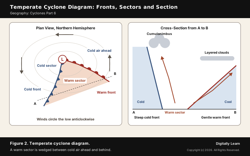
The temperate cyclone diagram in Figure 2 shows what a place feels as a cyclone passes from west to east. As the warm front approaches, a sequence of clouds spreads across the sky and steady rain falls. In the warm sector the weather clears and turns warmer. Then the cold front arrives from behind, pushes the warm air up into cumulus and cumulonimbus clouds, brings heavy showers and thunder, and the temperature falls as the wind veers.
- Comma cloud: Seen from a satellite, a mature cyclone forms a comma-shaped cloud pattern, with heavy precipitation near the head of the comma.
- Warm conveyor belt: A stream of warm, moist air from the warm sector rises ahead of the cold front and over the warm front, feeding the cloud and rain.
- Pressure: Pressure falls as the fronts approach and rises sharply once the cold front has passed.
Jet Streams, Upper-Level Divergence and Bomb Cyclones
Jet Stream and Upper-Level Divergence in Cyclone Formation
What happens near the surface is tied to the air aloft. Over a low, air converges near the ground and rises; for the low to deepen, more air must leave the top of the column than enters at the bottom. That outflow, called upper-level divergence, is strongest in certain quadrants of a jet streak, a core of fast wind within the polar jet stream at about 9 km.
The jet stream does not run straight. Its large meanders are Rossby waves, which travel east more slowly than the wind within them. When the flow is straight from west to east, called a zonal flow, cyclones race east; when it buckles into deep troughs and ridges, a meridional flow, they slow down and may turn north or south. A strong, stationary anticyclone can block a cyclone's path altogether.
Explosive Cyclogenesis and Bomb Cyclones
Sometimes a temperate cyclone deepens very fast. Explosive cyclogenesis, popularly a bomb cyclone, is the rapid deepening of an extratropical low: at 60 degrees latitude, a fall in central pressure of 24 millibars or more in 24 hours, roughly one millibar an hour. It is mostly a winter event over the sea, near sharp temperature contrasts such as the Gulf Stream, and it is the extratropical counterpart of rapid intensification in tropical cyclones.
| Storm | Lowest pressure | What it did |
|---|---|---|
| Cyclone near Iceland, 14 and 15 December 1986 | Below 920 mb | A pressure equal to a category 5 hurricane |
| Great Storm of 1987, Britain and Ireland | 953 mb | Winds of 220 km per hour; 19 deaths, 15 million trees lost |
| US Midwest storm, 26 October 2010 | 955.2 mb at Bigfork, Minnesota | Record low over land in the continental US outside hurricanes; 61 tornadoes |
| North Pacific storm off Washington, 24 and 25 October 2021 | 942.5 mb | Equal to a category 4 hurricane; fell more than 24 mb in 24 hours |
These storms show that a temperate cyclone can match a hurricane in pressure and wind, though most are weaker. Winds range from 15 to 30 km per hour in a mild cyclone to more than 119 km per hour in a severe one, which is why Europe calls the strongest of them windstorms.
Temperate Cyclone and Tropical Cyclone: Differences, and Anticyclones
Difference Between Temperate and Tropical Cyclone
The two kinds of cyclone share a low centre and a cyclonic circulation, and little else. A tropical cyclone is a warm-cored, non-frontal low that draws its energy from condensation in towering cumulonimbus clouds over warm seas above 27 degrees C. A temperate cyclone is a frontal low that draws its energy from the contrast between cold and warm air masses, and it becomes a cold-core system as it ages.
| Point | Temperate cyclone | Tropical cyclone |
|---|---|---|
| Where it forms | Middle and high latitudes, usually 30 to 60 degrees | Warm tropical oceans |
| Source of energy | Contrast between cold and warm air masses | Condensation over warm sea water |
| Fronts | Clear frontal system | No fronts |
| Eye | No eye | Calm eye of sinking air, ringed by the eyewall |
| Land and sea | Forms over land and sea | Forms only over sea; dies after landfall |
| Area | Covers a much larger area | Smaller, but more intense |
| Wind | Usually weaker | Much higher wind speeds; more destructive |
| Direction of movement | West to east, with the westerlies | East to west, with the trade winds |
The eye is the clearest marker. In a mature tropical cyclone the air subsides in the calm eye and rises in the eyewall, where the winds reach their maximum; a temperate cyclone never develops an eye, only fronts. The full structure of a tropical cyclone is covered in Cyclones Part 1.
Anticyclones and Blocking Highs in the Middle Latitudes
An anticyclone is the opposite of a cyclone: a high-pressure area where air subsides from above and diverges at the surface. Its winds turn clockwise in the northern hemisphere and anticlockwise in the southern. With little cloud forming in the sinking air, a high typically brings clear skies.
The strongest highs are masses of cold air spreading from polar regions. The Siberian High is a cold-core high that often stays in place for more than a month in the coldest part of the year, and the Azores High brings fair weather to much of the North Atlantic and summer heat waves to western Europe. A slow-moving high can block the path of a temperate cyclone and divert or weaken it.
- Winter over India: A high-pressure centre develops north of the Himalaya, and cold, dry continental winds blow out of it; over the northern plains feeble high-pressure conditions set in.
- Rain in that season: The winter winds bring little rain, partly because of the anticyclonic circulation over land; the winter rain of north-west India comes from western disturbances, which are cyclonic lows.
Storm Tracks, Western Disturbances and Effects of Temperate Cyclones
Storm Tracks, the Icelandic Low and the Aleutian Low
Temperate cyclones travel along narrow zones called storm tracks. The Atlantic and Pacific tracks begin in the western parts of each ocean, where the contrast between cold land and warm sea is sharpest in winter, and they end in the east, where the storms fill up and decay once they reach land. In the southern hemisphere a circumpolar storm track runs round Antarctica without any help from land-sea contrast.
- Icelandic Low: A semi-permanent low between Iceland and southern Greenland, a main centre of cyclone activity in the North Atlantic; with the Azores High it forms the North Atlantic Oscillation.
- Aleutian Low: A semi-permanent low near the Aleutian Islands in the Bering Sea in winter, where North Pacific cyclones slow down and reach their greatest strength.
- Numbers: About 234 significant temperate cyclones form in the northern hemisphere each winter, and on average 37 exist at any time in the southern hemisphere between 30 and 70 degrees S.
- Nor’easters: Cold-core lows off the east coast of North America, fed by the contrast between Canadian air and the warm Atlantic.
Western Disturbances: Western Temperate Cyclones over India
India's own temperate cyclones are the western disturbances, also called western cyclonic disturbances. They are low-pressure systems that originate over the Mediterranean Sea and western Asia and move into India with the westerly flow, carried by the subtropical westerly jet. On the way their moisture is added to from the Caspian Sea and the Persian Gulf, and the Himalaya forces it out as rain and snow.
- Winter rain: The rain on the plains, locally called mahawat, is small in amount but of immense importance for rabi crops such as wheat.
- Snow in the mountains: About 30 per cent of the annual precipitation of Jammu and Kashmir, Ladakh, Himachal Pradesh and Uttarakhand falls in winter, mostly from western disturbances; the snowmelt feeds rivers downstream.
- Hazards: Intense snow, rain or hail can cause landslides and avalanches; dense fog and cold waves often follow a disturbance.
- Forecasting: The India Meteorological Department issues district-level warnings; a Forecast Demonstration Project has run since 2016, and a colour-coded winter warning bulletin since November 2020.
An average of four to five western disturbances form in a winter, and they are most active from November to February. The full account of their tracks, rainfall and effects on the monsoon is in Cyclones Part 7: western disturbances.
Effects of Temperate Cyclones on Weather and Climate
Temperate cyclones bring the cyclonic or frontal rain of the middle latitudes, one of the three main types of rainfall. Their effects run from useful to disastrous.
- Rain and snow: A wide band of rain along the warm front, heavy showers along the cold front, and snow in winter when the whole troposphere is cold enough.
- Severe storms: Squall lines of thunderstorms can form ahead of cold fronts, bringing hail and high winds; with strong wind shear and a jet stream above, tornadoes can form.
- Windstorms: Deep lows bring gales to western Europe and the North Pacific coasts, felling trees and cutting power.
- Summer floods: Even a weak summer cyclone can flood; the July 2016 North China cyclone killed at least 184 people without gale-force winds.
- Heat transport: By carrying warm air poleward and cold air equatorward, the cyclones even out the temperature difference between the tropics and the poles.
Previous Year UPSC-CSE Questions
Previous Year UPSC-CSE Questions By the end you will be able to draft model answers for the following UPSC questions. Each question carries a collapsible framework showing how to approach it in the exam.
- UPSC Mains 2016 GS-IDiscuss the concept of air mass and explain its role in macro-climatic changes.
How to structure the answer in the exam
Introduction: Define an air mass as a large body of air with little horizontal variation in temperature and moisture, formed over a uniform source region.
Body (sub-themes to develop):
- Types by source region: mT, cT, mP, cP and cA.
- Modification: arctic air over a warm ocean becomes maritime polar.
- Fronts and temperate cyclones form where air masses meet, giving mid-latitude weather.
- Poleward heat transport through the polar front and its cyclones evens out the temperature gradient.
- India: dry continental air in winter; maritime tropical air as the south-west monsoon.
Conclusion: Conclude that air masses carry the climate of one region into another, and their meeting zones make the weather of the middle latitudes.
- UPSC Prelims 2015 Prelims-GSConsider the following statements:
- The winds which blow between 30° N and 60° S latitudes throughout the year are known as westerlies.
- The moist air masses that cause winter rains in North-Western region of India are part of westerlies.
How to approach this Prelims question
Approach: Check the latitudes of the westerlies, then the origin of the winter rain.
Trap to watch: The belt is 30 to 60 degrees in each hemisphere, not 30 degrees N to 60 degrees S.
Key facts to recall:
- Westerlies blow between 30 and 60 degrees latitude
- Western disturbances come from the Mediterranean with the westerly flow
Answer signal: Statement 2 only, option (b).
- UPSC Prelims 2011 Prelims-GSWesterlies in southern hemisphere are stronger and persistent than in northern hemisphere. Why?
- Southern hemisphere has less landmass as compared to northern hemisphere.
- Coriolis force is higher in southern hemisphere as compared to northern hemisphere
Which of the statements given above is/are correct?
How to approach this Prelims question
Approach: Keep the land-sea reason; test the Coriolis statement against its dependence on latitude.
Trap to watch: The Coriolis force is the same at the same latitude in both hemispheres.
Key facts to recall:
- Roaring Forties between 40 and 50 degrees S
- Land slows and bends the westerlies
Answer signal: Statement 1 only, option (a).
- UPSC Prelims 2020 Prelims-GSConsider the following statements:
- Jet streams occur in the Northern Hemisphere only.
- Only some cyclones develop an eye.
- The temperature inside the eye of a cyclone is nearly 10°C lesser than that of the surroundings.
Which of the statements given above is/are correct?
How to approach this Prelims question
Approach: Take each statement to the matching fact: jet streams, eyes, eye temperature.
Trap to watch: The eye of a tropical cyclone is warm, not 10 degrees C colder.
Key facts to recall:
- Each hemisphere has its own polar jet
- Temperate cyclones have fronts, not an eye
Answer signal: Statement 2 only, option (c).
- UPSC Prelims 2001 Prelims-GSAssertion and Reason:
- Assertion (A): Anti-cyclonic conditions are formed in winter season when atmospheric pressure is high and air temperatures are low.
- Reason (R): Winter rainfall in Northern India causes development of anticyclonic conditions with low temperatures.
How to approach this Prelims question
Approach: Judge the assertion and the reason separately.
Trap to watch: Winter rain comes from low-pressure systems; it cannot create high pressure.
Key facts to recall:
- A high develops north of the Himalaya in winter
- Western disturbances are cyclonic lows
Answer signal: A is true but R is false, option (c).
Sources
- NCERT: Fundamentals of Physical Geography (Class XI), Atmospheric Circulation and Weather Systems
- NCERT: Fundamentals of Physical Geography (Class XI), Water in the Atmosphere
- NCERT: India Physical Environment (Class XI), Climate
- NCERT: Contemporary India I (Class IX), Climate
- NOAA JetStream: Air Masses
- NOAA JetStream: Norwegian Cyclone Model
- NASA Earth Observatory: Extratropical Cyclone Whips Over the Pacific Northwest (2024)
- NASA Earth Observatory: Strong Extratropical Cyclone Over the US Midwest (2010)
- NASA Earth Observatory: Extratropical Cyclones Drench West Coast (2021)
- PIB (Ministry of Earth Sciences): Impact of western disturbances during winter on Indian climate, 2021
- Wikipedia: Extratropical cyclone
- Wikipedia: Norwegian cyclone model
- Wikipedia: Polar front
- Wikipedia: Bergen School of Meteorology
- Wikipedia: Jacob Bjerknes
- Wikipedia: Air mass
- Wikipedia: Weather front
- Wikipedia: Warm front
- Wikipedia: Cold front
- Wikipedia: Occluded front
- Wikipedia: Stationary front
- Wikipedia: Westerlies
- Wikipedia: Roaring Forties
- Wikipedia: Jet stream
- Wikipedia: Explosive cyclogenesis
- Wikipedia: Anticyclone
- Wikipedia: Storm track
- Wikipedia: Icelandic Low
- Wikipedia: Aleutian Low
- Wikipedia: Western disturbance
- Wikipedia: Nor'easter
- Wikipedia: Tropical cyclone
- UPSC: Civil Services Examination question papers
Disclaimer
This article draws on the NCERT geography textbooks, NOAA, NASA, the Press Information Bureau and the other sources listed on this page. Storm strengths and tracks vary from year to year.