
Overview
ITCZ, subtropical westerly and tropical easterly jets, ENSO, IOD, MJO
How pressure belts, jet streams, the Tibetan Plateau heat source, and three oceanic teleconnections drive and modulate the Indian monsoon.
Previous Year UPSC-CSE Questions By the end you will be able to draft model answers for the following UPSC questions. Each question carries a collapsible framework showing how to approach it in the exam.
- UPSC Prelims 2017 General StudiesWith reference to 'Indian Ocean Dipole (IOD)', sometimes mentioned in the news while forecasting Indian monsoon, which of the following statements is/are correct?
- IOD phenomenon is characterised by a difference in sea surface temperature between tropical Western Indian Ocean and tropical Eastern Pacific Ocean.
- An IOD phenomenon can influence an El Nino's impact on the monsoon.
Select the correct answer using the code given below:
How to approach this Prelims question
Approach: Two-statement evaluation testing IOD definition (Indian Ocean east-west not Pacific) and IOD-ENSO interaction.
Trap to watch: Aspirants may accept Statement 1 because both IOD and ENSO involve SST anomalies. The trap is Statement 1 conflates the two oceans: IOD is Indian-Ocean only, ENSO involves the Pacific.
Key facts to recall:
- IOD definition: SST oscillation in the Indian Ocean only (Western vs Eastern Indian Ocean).
- ENSO domain: Tropical Pacific (Eastern Pacific warming = El Nino).
- IOD-ENSO interaction: Positive IOD can offset El Nino monsoon-weakening; negative IOD can reinforce La Nina monsoon strengthening.
- 2019 example: Strong positive IOD produced strong Indian monsoon despite weak El Nino.
Answer signal: 2 only
- UPSC Prelims 2024 General StudiesWith reference to 'Coriolis force', which of the following statements is/are correct?
- It increases with increase in wind velocity.
- It is maximum at the poles and is absent at the equator.
Select the answer using the code given below:
How to approach this Prelims question
Approach: Two-statement evaluation testing fundamental properties of the Coriolis force.
Trap to watch: Aspirants may doubt Statement 2 because winds blow strongly at equatorial latitudes too. The trap is that what is absent at the equator is the DEFLECTION (Coriolis force), not the wind itself.
Key facts to recall:
- Coriolis force: Apparent deflective force from Earth's rotation; deflects N-Hemisphere winds right, S-Hemisphere winds left.
- Velocity dependence: F = 2 × omega × v × sin(latitude); increases linearly with wind velocity.
- Latitude dependence: Maximum at poles, zero at equator (sin of latitude).
- Indian monsoon application: S-Hemisphere south-easterly trades become S-Hemisphere south-westerlies after crossing equator into N-Hemisphere because of Coriolis deflection.
Answer signal: Both 1 and 2
Indian climate is animated through the seasonal cycle by the second group of factors covering air pressure and wind. The first of these three factors is the seasonal distribution of air pressure and surface winds: a Central Asian high pressure in winter pushes dry north-easterlies into India, while an Inter-Tropical Convergence Zone over the Indo-Gangetic plain in summer draws in the moist south-west monsoon. The second factor is the upper-air jet stream circulation: the subtropical westerly jet at approximately 25 degrees North in winter steers Western Disturbances from the Mediterranean, while the tropical easterly jet at approximately 15 degrees North in summer steers Bay of Bengal depressions. The third factor is the inflow of disturbances: Western Cyclonic Disturbances in winter and tropical depressions in summer. Three oceanic teleconnections, the El Nino-Southern Oscillation (ENSO), the Indian Ocean Dipole (IOD), and the Madden-Julian Oscillation (MJO), modulate inter-annual and intra-seasonal monsoon variability.
Background and Historical Context
The seasonal interaction of pressure, wind, jet stream, and oceanic teleconnection determines whether the south-west monsoon in any year is normal, deficient, or excess. Indian agriculture's kharif season, hydropower generation, urban water security, and food inflation all depend on the seasonal forecast skill of the India Meteorological Department, which in turn rests on understanding these atmospheric and oceanic drivers. UPSC has examined ITCZ, jet streams, ENSO, IOD, and Coriolis force in Prelims and Mains GS-I climatology papers across multiple cycles.
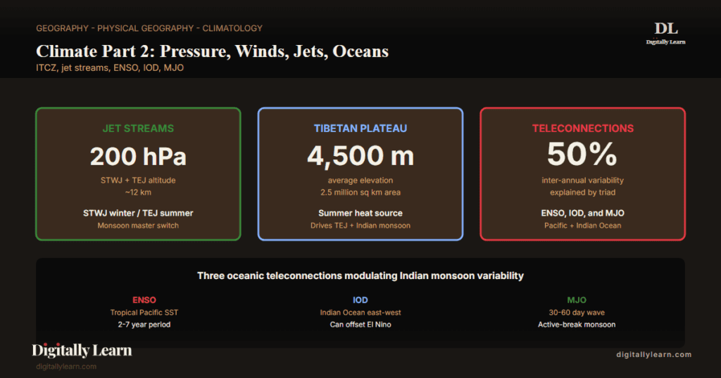
What is the significance of jet streams and oceanic teleconnections for India? Three structural mechanisms interact to govern the monsoon machinery and its variability. The Subtropical Westerly Jet in winter steers Western Disturbances from the Mediterranean to the Indo-Gangetic plain (covered in our Western Disturbances entry); the same jet retreats north in summer to allow monsoon onset. The Tibetan Plateau, with elevation around 4,500 metres and area over 2.5 million square kilometres, functions as a summer heat source generating an upper-tropospheric anticyclone that drives the Tropical Easterly Jet. The ENSO-IOD-MJO triad jointly modulates monsoon variability through Pacific and Indian Ocean teleconnections.
The India Meteorological Department issues a four-stage long-range forecast for the south-west monsoon integrating sixteen indicators including ENSO, IOD, MJO, Eurasian snow cover, and Tibetan Plateau heating. The National Centre for Medium Range Weather Forecasting (NCMRWF) at Noida runs the operational numerical weather prediction system. Climate-change modelling suggests that the subtropical jet waviness is increasing under Arctic warming, producing more anomalous Western Disturbance activity in winter. The Monsoon Mission initiative funds the modelling improvements that lift forecast skill year by year.
Air-Pressure-and-Wind Factors: The Second Group
Three factors that animate the seasonal climate
Indian climate is controlled by two groups of factors: the first group of location and relief covered in Climate Part 1, and the second group of air pressure and wind that animates the geographical setting through the seasonal cycle.
The air-pressure-and-wind group has three components. The first is the seasonal distribution of air pressure and surface winds across India. The second is the upper-air circulation driven by global weather controls and jet streams. The third is the inflow of Western Disturbances in winter and tropical depressions during the south-west monsoon. These three components combine differently across the seasons to produce the dual-regime monsoon climate of India.
| Factor | Winter manifestation | Summer manifestation |
|---|---|---|
| Surface pressure and winds | Central Asian high pressure pushes dry NE winds south | ITCZ low over Indo-Gangetic plain draws SW monsoon |
| Upper-air jet streams | Subtropical westerly jet at 25 deg N south of Himalayas | Tropical easterly jet at 15 deg N peaking June at 90 km/h |
| Inflow of disturbances | Western Cyclonic Disturbances from Mediterranean | Tropical depressions originating in Bay of Bengal |
Mechanism of Weather in the Winter Season
Surface pressure and winds: the Central Asian high
In winter the weather over India is governed largely by the distribution of air pressure in Central and Western Asia. A high-pressure centre develops north of the Himalayas, building strength through the cold half of the year. This cell drives a flow of cold continental air at low levels toward the subcontinent. The surface winds blowing out of the Central Asian high reach India as a dry continental air mass and meet the trade winds over north-western India.
The boundary between the dry continental flow and the trade winds is not a stable line. It can shift eastward as far as the middle Ganga valley, in which case the whole of north-western and northern India up to that valley falls under the influence of dry north-westerly winds and a sharp winter chill.
Upper-air circulation: the subtropical westerly jet
Above the surface-wind pattern, at altitudes between nine and thirteen kilometres, the troposphere over Asia carries powerful westerly winds known as jet streams. These west-to-east jet streams blow across Asia at latitudes north of the Himalayas, roughly parallel to the Tibetan highlands. The highlands themselves act as a barrier and force the jet stream to bifurcate.
One branch flows north of the highlands; the southern branch flows in an eastward direction south of the Himalayas. The mean position of the southern branch is approximately 25 degrees North in February at the 200-300 millibar pressure level. This southern subtropical westerly jet exercises an important influence on winter weather over India because it steers eastward-travelling cyclonic systems into the subcontinent.
Western Cyclonic Disturbances and winter precipitation
The Western Cyclonic Disturbances enter the Indian subcontinent from the west and north-west during the winter months. They originate over the Mediterranean Sea, gather moisture as they track east across Iran and Afghanistan, and are brought into India by the southern subtropical westerly jet stream. An increase in prevailing night temperature generally signals the advance arrival of a Western Disturbance.
These systems deliver the bulk of north-western India's winter precipitation, the small but agronomically vital rainfall that sustains the rabi-crop season for wheat, mustard, and pulses. The Western Disturbances also bring snowfall to Jammu and Kashmir, Himachal Pradesh, and Uttarakhand, recharging the Himalayan glacier and snowpack reserves that feed the perennial rivers.
- Origin: Mediterranean Sea; track east through Iran, Afghanistan, Pakistan into India.
- Steering mechanism: Southern branch of subtropical westerly jet stream at the 200-300 mb level.
- Affected regions: Punjab, Haryana, Delhi, north-western Uttar Pradesh, Jammu and Kashmir, Himachal Pradesh, Uttarakhand.
- Agricultural significance: Bulk of rabi season precipitation for wheat, mustard, gram, pulses.
- Glaciological significance: Snowfall above 2,000 metres feeds Himalayan glaciers and the perennial rivers that depend on them.
- Tropical cyclones (winter): Bay of Bengal and Indian Ocean cyclones occasionally strike Tamil Nadu, Andhra Pradesh, and Odisha coasts in the early winter months.
Mechanism of Weather in the Summer Season
ITCZ shifts north and the wind pattern reverses
As summer sets in and the sun shifts northward, the wind circulation over the subcontinent undergoes a complete reversal at both lower and upper levels. By the middle of July the low-pressure belt near the surface, called the Inter-Tropical Convergence Zone (ITCZ), shifts northward, roughly parallel to the Himalayas between 20 and 25 degrees North. By this time the subtropical westerly jet stream withdraws from the Indian region.
Meteorologists have established an interrelationship between the northward shift of the equatorial trough and the withdrawal of the westerly jet; the two events are causally linked rather than coincidental. The ITCZ, being a zone of low pressure, attracts inflow of winds from different directions. The maritime tropical air mass from the southern hemisphere, after crossing the equator, rushes to the low-pressure area in a general south-westerly direction. This moist current is what is popularly known as the south-west monsoon.
Upper-air circulation: the tropical easterly jet
The summer surface-pressure-and-wind pattern is mirrored aloft by an easterly jet stream that flows over the southern part of the Peninsula. In June the easterly jet reaches a maximum speed of approximately 90 kilometres per hour. By August it has settled at around 15 degrees North, and in September it extends up to 22 degrees North. The easterlies normally do not extend north of 30 degrees North in the upper atmosphere.
The tropical easterly jet steers the tropical depressions originating over the Bay of Bengal across the subcontinent, and the tracks of these depressions become the highest-rainfall corridors in India. The frequency, direction, and intensity of these depressions together determine the rainfall pattern during the south-west monsoon season; a year with frequent depressions produces a vigorous monsoon, while a year with few depressions produces a sub-normal monsoon.
- Tropical easterly jet position: Peninsular India 15 deg N in August, 22 deg N in September; never extends north of 30 deg N.
- Peak speed: Approximately 90 km per hour in June.
- Steering function: Directs Bay of Bengal tropical depressions across India.
- Rainfall corridor: Depression tracks become the highest-rainfall areas of the year.
- Cause and effect with ITCZ shift: Easterly jet sets in only after the westerly jet has withdrawn northward.
The Inter-Tropical Convergence Zone and the Monsoon Trough
Where the trade winds converge
The Inter-Tropical Convergence Zone (ITCZ) is a low-pressure zone located near the equator where the trade winds of the two hemispheres converge. Because the converging winds force the air upward, the ITCZ is also a zone of ascending air, condensation, and heavy rainfall on a global scale.
The position of the ITCZ migrates with the apparent solar motion: when the sun is overhead at the Tropic of Cancer in June, the ITCZ migrates northward to roughly that latitude; when the sun is overhead at the Tropic of Capricorn in December, the ITCZ migrates south of the equator. India's distinctive monsoon climate is a direct consequence of the seasonal northward migration of the ITCZ into the Indo-Gangetic plain.
In July, the ITCZ is located around 20 to 25 degrees North latitudes over the Gangetic plain, where it is commonly called the monsoon trough. The monsoon trough encourages the development of a thermal low pressure over north and north-west India.
The northward shift of the ITCZ also redirects the trade winds of the southern hemisphere; they cross the equator between 40 degrees East and 60 degrees East longitudes and, under the influence of the Coriolis force, start blowing from south-west to north-east. The redirected trade flow becomes the south-west monsoon over India. In winter the ITCZ moves southward, and the wind reversal goes the other way, producing the north-east monsoon that brings rainfall to the southern Peninsula.
The Tibetan Plateau as an Elevated Heat Source
How the plateau drives upper-tropospheric warming and the easterly jet
The Tibetan Plateau averages around 4,500 metres in elevation and stretches across approximately 2.5 million square kilometres. Its sheer size and altitude make it a unique elevated heat source in summer. While the surrounding free atmosphere at the same altitude is cold, the heated plateau surface conducts and radiates warmth into the upper troposphere, creating a layer of warmer-than-surroundings air over Tibet that is hundreds of millibars thick.
This warming generates an upper-tropospheric anticyclone that becomes the engine of the tropical easterly jet running across peninsular India. The plateau also bifurcates the winter subtropical westerly jet, sending one branch south of the Himalayas where it can steer Western Disturbances into India. Without the Tibetan Plateau in this geometry, neither the easterly jet nor the winter steering pattern would exist in their current form.
Oceanic Teleconnections: ENSO, Indian Ocean Dipole, MJO
El Nino-Southern Oscillation and Indian monsoon variability
The El Nino-Southern Oscillation (ENSO) is a coupled ocean-atmosphere mode of the tropical Pacific that explains a significant fraction of inter-annual Indian monsoon variability. ENSO is a complex weather phenomenon that appears every three to seven years, bringing drought, floods, and other extremes to different parts of the world. The phenomenon involves the appearance of warm currents off the coast of Peru in the Eastern Pacific that replace the cold Peruvian or Humboldt current temporarily.
During an El Nino the warming raises Peruvian-coast water temperature appreciably above normal. The Indian Ocean responds to the Pacific anomaly through atmospheric teleconnection, and the south-west monsoon over India weakens as a result. Strong El Nino years such as 1972, 1987, 2002, 2009, and 2015 produced deficient monsoons in India. ENSO is therefore used by the India Meteorological Department as a primary input for long-range monsoon forecasting.
In 1990-91, a strong El Nino event delayed the onset of the south-west monsoon over most parts of India by between five and twelve days. La Nina, the opposite phase of ENSO, is associated with above-normal monsoon performance in India through the reverse atmospheric teleconnection. ENSO does not, however, deterministically predict the Indian monsoon; the strong 1997 El Nino did not produce drought in India, a reminder that other factors including the Indian Ocean Dipole can offset ENSO's influence.
Indian Ocean Dipole and the Indian-Pacific teleconnection
The Indian Ocean Dipole (IOD) is an SST contrast between the western and eastern equatorial Indian Ocean that operates independently of, but interacts with, ENSO. In a positive IOD the western Indian Ocean off the African coast becomes anomalously warm while the eastern Indian Ocean off Indonesia becomes anomalously cool.
The warm western pool intensifies convection over the western Indian Ocean and modulates the south-west monsoon over India, often strengthening it and partially offsetting the drying influence of El Nino in the Pacific. The strong positive IOD event of 2019 produced exceptionally heavy rainfall over East Africa while contributing to a strong Indian monsoon despite weak El Nino conditions in the Pacific.
Madden-Julian Oscillation and intra-seasonal active-break cycles
The Madden-Julian Oscillation (MJO) is a 30 to 60 day eastward-propagating envelope of tropical convection that explains much of the intra-seasonal variability within any single monsoon. When the MJO active phase sits over the Indian Ocean, monsoon convection over India intensifies, producing an active monsoon spell.
When the MJO suppressed phase sits over the Indian Ocean, monsoon convection weakens or fails, producing a break monsoon spell. The active-and-break alternation visible in any monsoon season is therefore not random; it tracks the position of the MJO envelope and can be forecast some weeks in advance with skill.
IMD Long-Range Forecasting and the Monsoon Mission
Forecasting structure built on the air-pressure-and-wind factors
The India Meteorological Department (IMD) issues a four-stage long-range forecast for the south-west monsoon, based on a sixteen-indicator framework that integrates ENSO, IOD, and MJO indices with surface-pressure and upper-air signals. The first-stage forecast is issued in April, before monsoon onset, and is updated successively in May, June-July, and August-September as new observational data become available.
The forecasting framework rests on the same physical principles described in this article, that the monsoon strength reflects the joint state of the surface-pressure pattern, the upper-air jet circulation, and the inflow of disturbances and depressions. The Monsoon Mission initiative funds national modelling investments to improve the skill of these forecasts year by year.
- Four-stage forecast cycle: April first-stage, May update, June-July update, August-September update.
- Sixteen-indicator input set: Includes ENSO indices, IOD index, MJO index, Eurasian snow cover, Tibetan Plateau temperature, surface pressure anomalies.
- National Centre for Medium Range Weather Forecasting (NCMRWF): Operational numerical weather prediction division at Noida that runs the dynamical models supporting forecasts.
- Monsoon Mission: National programme funding the modelling improvements that have steadily raised forecast skill over recent monsoon seasons.
Observable Outcomes of the Air-Pressure-and-Wind System
How the three factors produce the seasonal lived climate of India
The three air-pressure-and-wind factors interacting through the seasonal cycle produce a small number of distinctive features that define how the climate of India is lived rather than merely catalogued.
- Seasonal wind reversal: North-east winter winds reverse into south-west summer winds as the ITCZ migrates northward and the Central Asian high gives way to the Indo-Gangetic low.
- Winter rabi-crop precipitation: Western Disturbances steered by the southern branch of the subtropical westerly jet deliver the small but agronomically essential rainfall that sustains wheat, mustard, and pulses.
- Summer monsoon burst: The withdrawal of the westerly jet and the establishment of the tropical easterly jet at 15 degrees North trigger the explosive onset of the south-west monsoon.
- Depression-track rainfall corridors: Bay of Bengal depressions steered by the easterly jet trace the highest-rainfall belts across central and eastern India.
- Inter-annual variability: ENSO, IOD, and MJO together explain a significant fraction of why one monsoon year is normal, deficient, or excess.
- Forecasting skill: The IMD’s four-stage long-range forecast operationalises these factor relationships into actionable inputs for agriculture, water management, hydropower, and disaster preparedness.
The next entry in this cluster, Climate Part 3, develops the classical and dynamic theories of the monsoon and the onset-and-withdrawal sequence that closes the seasonal cycle.
Prelims MCQ practice
Each question below tests one specific concept on the topic. Click to reveal the answer and a full option-wise explanation.
Q1. Consider the following statements about the summer pressure system over the Indian Subcontinent:
- During summer, intense heating creates a deep low-pressure trough over northwestern India and Pakistan (the ITCZ/monsoon trough).
- This low-pressure trough draws moist southwesterly winds from the Indian Ocean, driving the southwest monsoon onset.
Which of the statements given above is/are correct?
- 1 only
- 2 only
- Both 1 and 2
- Neither 1 nor 2
Show answer and explanation
Answer: Both 1 and 2
Explanation.
Correct: c (Both 1 and 2). Both statements are correct. Intense summer heating creates a deep low-pressure trough (the ITCZ shifted north to lie roughly over north-west India and the Indo-Gangetic plain, the 'monsoon trough'). This low draws moist southwesterly winds across the Indian Ocean, driving the southwest monsoon onset.
Q2. Consider the following statements about the winter pressure system over the Indian Subcontinent:
- During winter, the cold continental landmass develops a high-pressure cell over north-west India and Pakistan.
- Cold dry winds (northeasterly trades) blow from this high-pressure cell out over the Bay of Bengal, where they pick up moisture and cause winter rainfall in southeast India (Tamil Nadu).
Which of the statements given above is/are correct?
- 1 only
- 2 only
- Both 1 and 2
- Neither 1 nor 2
Show answer and explanation
Answer: Both 1 and 2
Explanation.
Correct: c (Both 1 and 2). Both statements are correct. The winter high-pressure cell develops over the cold continental landmass of north-west India and Pakistan. Cold dry northeasterly trade winds blow from this high outward; when they cross the Bay of Bengal they pick up moisture and cause winter rainfall (the 'northeast monsoon') in southeast India, particularly Tamil Nadu and coastal Andhra.
Q3. Consider the following statements about Western Disturbances:
- Western Disturbances are extratropical low-pressure systems that originate over the Mediterranean and Caspian regions.
- They are steered eastward by the sub-tropical westerly jet stream and bring winter rainfall and snowfall to north and northwest India.
- They are responsible for the bulk of summer monsoon rainfall in central India.
Which of the statements given above are correct?
- 1 and 2 only
- 2 and 3 only
- 1 and 3 only
- 1, 2 and 3
Show answer and explanation
Answer: 1 and 2 only
Explanation.
Correct: a (1 and 2 only). Statement 1 is correct: Western Disturbances originate over the Mediterranean and Caspian regions. Statement 2 is correct: they are steered eastward by the sub-tropical westerly jet stream and bring winter rain/snow to north India. Statement 3 is wrong: Western Disturbances bring WINTER rainfall, NOT summer monsoon; the summer monsoon is driven by the southwest monsoon system, not Western Disturbances.
Q4. Consider the following statements about the Inter-Tropical Convergence Zone (ITCZ) and the Indian monsoon:
- The ITCZ is a low-pressure belt of converging trade winds where the northeast and southeast trades meet.
- The northward shift of the ITCZ to lie over the Indian Subcontinent in summer is a key driver of the southwest monsoon onset.
Which of the statements given above is/are correct?
- 1 only
- 2 only
- Both 1 and 2
- Neither 1 nor 2
Show answer and explanation
Answer: Both 1 and 2
Explanation.
Correct: c (Both 1 and 2). Both statements are correct. The ITCZ is the low-pressure equatorial convergence belt where NE and SE trade winds meet. Its northward seasonal shift to lie over the Indian Subcontinent in summer (driven by maximum-insolation movement north) is a fundamental driver of the southwest monsoon onset.
Q5. Consider the following statements about the Indian Ocean Dipole (IOD):
- Positive IOD occurs when the western Indian Ocean is warmer than the eastern Indian Ocean.
- Positive IOD is generally associated with above-normal southwest monsoon rainfall over India.
- Negative IOD is generally associated with above-normal rainfall over Indonesia and northern Australia.
Which of the statements given above are correct?
- 1 and 2 only
- 2 and 3 only
- 1 and 3 only
- 1, 2 and 3
Show answer and explanation
Answer: 1, 2 and 3
Explanation.
Correct: d (1, 2 and 3). All three are correct. Positive IOD = warmer western Indian Ocean than eastern (anomalous SST gradient). Positive IOD is generally associated with above-normal SW monsoon rainfall over India and below-normal rainfall over Indonesia/Australia. Negative IOD is the reverse, with above-normal rainfall over Indonesia/Australia.
Q6. Consider the following statements about the Coriolis effect on Indian climate:
- The Coriolis effect deflects winds to the right in the Northern Hemisphere and to the left in the Southern Hemisphere.
- The cross-equatorial flow during the southwest monsoon experiences Coriolis deflection that turns the southerly winds into southwesterlies after crossing the equator.
Which of the statements given above is/are correct?
- 1 only
- 2 only
- Both 1 and 2
- Neither 1 nor 2
Show answer and explanation
Answer: Both 1 and 2
Explanation.
Correct: c (Both 1 and 2). Both statements are correct. The Coriolis effect deflects winds to the right in the NH (and to the left in the SH). Cross-equatorial flow from the southern Indian Ocean reaches the equator as southeasterlies; after crossing into the Northern Hemisphere the Coriolis deflection turns them into southwesterlies (the southwest monsoon winds).
Sources and Further Reading
- NCERT Class 11 India: Physical Environment, Chapter 4 – Climate (Mechanism of Weather)
- Wikipedia – Intertropical Convergence Zone
- Wikipedia – Jet stream
- Wikipedia – Indian Ocean Dipole
- Wikipedia – El Nino-Southern Oscillation
- Wikipedia – Madden-Julian oscillation
- Wikipedia – Tibetan Plateau
- Wikipedia – Coriolis force
- Wikipedia – Monsoon of South Asia
- Wikipedia – India Meteorological Department
- Wikipedia – Tropical cyclone
Disclaimer
This article is prepared for UPSC preparation by the Digitally Learn editorial team. Concepts, the IMD monsoon forecasting framework, and the major teleconnection patterns are cross-verified with standard authoritative reference sources. Readers should consult the latest official IMD and government releases for current-year monsoon data.


