


Overview
Desert soil of western Rajasthan: features, formation and crops
What arid soil is, where it is found, how wind and heat shape it, and how canal water and desertification change it.
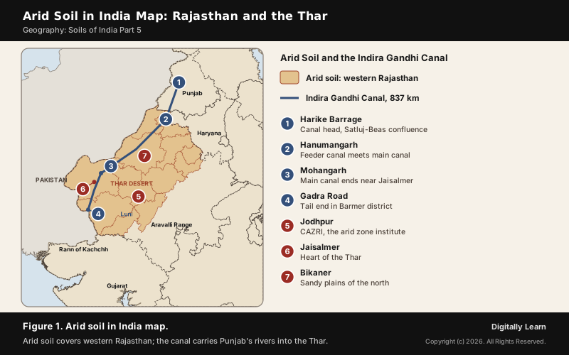
Arid soil, also called desert soil, is the red to brown, sandy and often saline soil of dry lands, where evaporation is greater than rainfall. In India it is characteristically developed in western Rajasthan. It lacks moisture and humus, is poor in nitrogen, and has kankar layers in its lower horizons; with irrigation it becomes cultivable.
Arid Soil in India: Meaning, Characteristics and Formation
What Is Arid Soil? Definition and Other Names
In dry regions the sun and wind take away more water than the rain brings, and the soil that forms there is arid soil. It ranges from red to brown in colour, is sandy and saline, and holds little moisture or humus. In India it is characteristically developed in western Rajasthan, a land of dunes and dry plains.
Arid soil and desert soil are the same soil under two names. In the American soil taxonomy it is an order called Aridisols, from the Latin aridus, dry, and these soils dominate the deserts and dry shrublands that cover about one-third of the Earth's land surface. Water shortage is the defining feature of an Aridisol.
Arid Soil Characteristics: Colour, Texture, Salts and Nutrients
The features of arid soil all come from a shortage of water. Because rain is scarce and evaporation fast, the soil keeps its salts, grows little vegetation and so gains little organic matter.
- Colour: Red to brown.
- Texture: Generally sandy.
- Salts: Saline in nature; in some areas the salt content is so high that common salt is obtained by evaporating the saline water.
- Moisture and humus: Lacking, because of the dry climate, high temperature and fast evaporation; these soils are poor and contain little humus and organic matter.
- Nutrients: Nitrogen is insufficient and the phosphate content is normal.
- Kankar: The lower horizons are occupied by kankar layers, because the calcium content increases downwards.
| Property | Arid soil |
|---|---|
| Colour | Red to brown |
| Texture | Sandy |
| Salt content | High, saline |
| Humus | Very little |
| Nitrogen | Insufficient |
| Phosphate | Normal |
| Lower horizons | Kankar layers |
How Arid Soil Is Formed: Evaporation, Salts and Kankar
The formation of arid soil is driven by a climate in which water rises instead of sinking. In dry climates, high temperature makes evaporation exceed precipitation, so ground water is brought up to the surface by capillary action. The water evaporates on the way and leaves its salts behind in the soil, where they can harden into a crust called a hardpan.
Where precipitation is intermediate, calcium carbonate collects as nodules called kankar. Because there is little leaching, dissolved minerals such as calcium carbonate, gypsum and soluble salts settle in the subsoil instead of being washed away. The parent material adds to this: much of the Thar's surface is wind-blown sand and sediment brought from the alluvial plains and the coast.
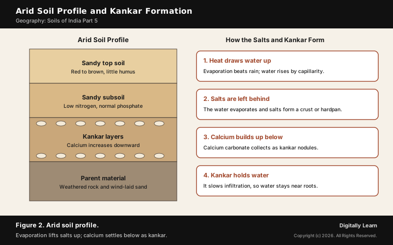
The kankar layer has a use. It restricts the infiltration of water, so when irrigation is made available the moisture stays within reach of roots and supports plant growth. That is why these soils become cultivable after proper irrigation, as in western Rajasthan. The layered structure of a soil is explained in soil profile and horizons.
Where Arid Soil Is Found in India: Rajasthan, the Thar and Dry Lands
Arid Soil in Rajasthan and the Thar Desert
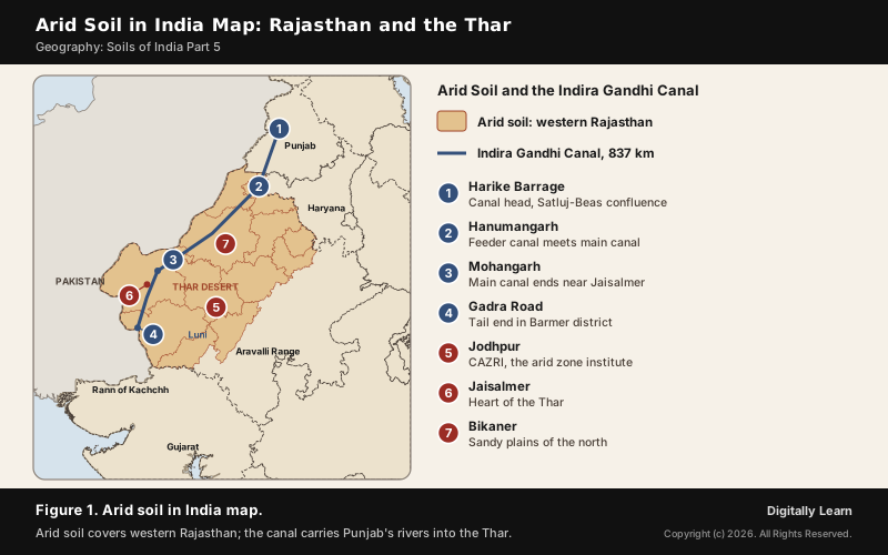
Arid soil, the desert soil in India, is found mainly in Rajasthan, in the west of the state, where it is characteristically developed. This is the Thar Desert, or Great Indian Desert, which covers 264,091 square km across India and Pakistan. About two-thirds of it lies in India, and it forms about six per cent of India's geographical area; most of the Indian part lies in Rajasthan, with small parts in Haryana, Punjab and Gujarat.
- Rainfall: Mostly from the south-west monsoon, and on average less than 500 mm a year, with long spells of drought.
- Relief: Sandy plains broken by low eroded hills in the east, falling to about 150 m at the India-Pakistan border; much of the desert is covered by sand dunes.
- Water: The Luni is the only major river system. It rises near Ajmer in the Aravalli Range and ends in the Rann of Kachchh after 495 km; it is also known as Lavanavati, the salt river, for its saline water.
- Ground water: Found at 10 to 40 m and mostly brackish.
Arid and Semi-Arid Regions of India, Including the Cold Desert
Arid land in India is wider than the Thar. The arid and semi-arid regions spread over ten states and cover 38.80 per cent of India's total geographical area. The cold arid zone of the Trans-Himalaya covers 5.62 per cent of the country, a desert made by cold and altitude rather than heat.
| Dry region | Rain a year |
|---|---|
| Desert | Under 50 mm, no vegetation |
| Arid region | 50 to 250 mm, sparse vegetation |
| Semi-arid region | 250 to 500 mm, steppe or savanna |
Most of the Thar gets 100 to 300 mm of rain a year, so on this scale it is largely arid; its eastern edge, with fewer dunes and slightly more rain, is semi-arid. Most deserts and dry regions of the world lie between 10 and 35 degrees of latitude, in the interiors of continents, or in rain shadows; why the great hot deserts sit near the tropics is explained in hot deserts of the world.
Arid Soils of the World: Aridisols, Calcisols, Gypsisols and Solonchaks
Arid soils elsewhere are named by what accumulates in them. In the World Reference Base used by the FAO, most Aridisols belong to four groups, each marked by a mineral that the scarce water could not wash away.
- Calcisols: Marked by an accumulation of calcium carbonate, the same process that makes kankar.
- Gypsisols: Show a large accumulation of gypsum in the upper metre of soil.
- Solonchaks: Have a high concentration of soluble salts; they are the saline soils, common in closed basins where salty water evaporates.
- Durisols: Have a layer hardened by silica cementation.
India's own saline and alkaline soils, treated in Part 7, are close relatives of the Solonchaks. They occur in arid and semi-arid regions as well as in waterlogged areas, which is why a canal can turn good arid soil into a saline one. The two are easily confused, so compare them.
| Feature | Arid soil | Saline soil |
|---|---|---|
| Other name | Desert soil | Usara soil |
| Where in India | Western Rajasthan | Western Gujarat, east coast deltas, Sundarbans |
| Salts | Saline; common salt in places | More sodium, potassium, magnesium |
| Calcium | Increases downward as kankar | Lacking |
| Fertility | Cultivable after irrigation | Infertile, no vegetative growth |
Aeolian Processes: How Wind Shapes Arid Soil and Sand Dunes
Wind Erosion in Deserts: Deflation, Abrasion and Impact
Wind is one of the two dominant agents in hot deserts. Aeolian processes are those of the wind: its ability to erode, carry and deposit material and so shape the surface. The dry, bare desert floor heats up quickly, the air above it rises in turbulent eddies and whirlwinds, and winds move across the floor at great speed.
- Deflation: The lifting and removal of dust and smaller particles from the surface. Persistent wind in one direction can scoop out shallow depressions called deflation hollows.
- Abrasion: Wind-borne sand and silt act as tools that scrape the land surface.
- Impact: The sheer force of sand blown against a rock surface, like sand-blasting.
- Sorting: Grains move by rolling, by saltation (bouncing along the surface) and in suspension, so wind deposits are well sorted by size.
Rain is scarce in deserts but falls torrentially, so sheet floods also move weathered debris. Wind erosion is significant in arid and semi-arid regions, while running water does more damage where rainfall is heavy and slopes are steep. Shelter belts, lines of trees that break the wind, have helped to stabilise sand dunes and the desert in western India.
Types of Sand Dunes: Barchan, Seif, Longitudinal and Transverse
Dry hot deserts are good places for sand dunes, and the Thar is largely covered by them. Its sand is highly mobile because of the strong winds that rise every year before the monsoon. Which dune forms depends on the wind's direction, the supply of sand and any vegetation.
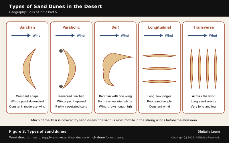
- Barchans: Crescent-shaped dunes with their wings pointing downwind; they form where the wind is constant and moderate and the surface is almost uniform.
- Parabolic dunes: Reversed barchans, formed where sandy surfaces are partly covered by vegetation.
- Seif: Like a barchan but with only one wing, formed when the wind shifts; the lone wing can grow very long and high.
- Longitudinal dunes: Long ridges of low height, formed where sand supply is poor and the wind direction constant.
- Transverse dunes: Aligned at right angles to the wind, formed where the sand source is an elongated feature across the wind.
Crops and Irrigation on Arid Soil: The Indira Gandhi Canal
Crops Grown in Arid Soil
Arid soil grows drought-resistant crops where there is no irrigation, and a much wider range where there is. In the canal area, soil moisture has been the limiting factor for growing crops.
- Rain-fed crops: Drought-resistant varieties of green gram, sesame, millets, cluster beans, chickpea and jowar.
- Near water: Melon, cucumber, citrus fruits and date palms.
- Traditional crops of the canal area: Gram, bajra and jowar.
- Under canal irrigation: Wheat, cotton, groundnut and rice have replaced the traditional crops.
Farmers also store water. Khadins are crop embankments that stop rain water from running off, and rain water is kept in natural and man-made reservoirs for the dry season. The millets and pulses of dry farming are covered in Agriculture Part 4.
Indira Gandhi Canal: Course, Stages and Command Area
The Indira Gandhi Canal, earlier the Rajasthan Canal, is one of the largest canal systems in India and the reason arid soil in western Rajasthan now grows wheat and cotton. Conceived by Kanwar Sain in 1948, the project was launched on 31 March 1958. The canal is 837 km long and begins at the Harike Barrage in Punjab, at the confluence of the Satluj and Beas.
- Course: It runs parallel to the Pakistan border, at an average distance of 40 km, through the Thar (Marusthali), and ends near Gadra Road in Barmer district.
- Sections: The Rajasthan Feeder (204 km, Harike to Masitawali in Hanumangarh), the main canal (445 km, Masitawali to Mohangarh, north-east of Jaisalmer), and two branches beyond, to Gunjangarh-Ramgarh and then towards Gadra Road.
- Command area: The whole system of 9,060 km is planned to irrigate a culturable command area of 19.63 lakh hectares, about 70 per cent by flow and the rest by lift canals.
- Stage I: Ganganagar, Hanumangarh and northern Bikaner, 5.53 lakh hectares, irrigated from the early 1960s.
- Stage II: Bikaner, Jaisalmer, Barmer, Jodhpur, Nagaur and Churu, 14.10 lakh hectares of shifting dunes and 50 degrees C summers, irrigated from the mid-1980s.
In a lift canal water is lifted so that it can flow against the slope of the land. All the lift canals start from the left bank of the main canal; the canals on the right bank are flow channels.
Waterlogging and Soil Salinity in the Canal Command Area
Canal water changed the desert in both directions. Longer soil moisture, afforestation and pasture programmes have greened the land, reduced wind erosion and cut the siltation of the canals. But intensive irrigation and excessive use of water have brought the twin problems of waterlogging and soil salinity, which in the long run threaten the sustainability of farming there.
The mechanism is the arid soil's own. Irrigation water that collects in the soil evaporates and leaves its salts behind, and over-irrigation brings the salt lodged in the lower profile up to the surface. Across India, a fairly large area of irrigated land is becoming saline this way. Of the seven measures proposed to make the command area sustainable, five aim to restore its ecological balance; the main ones are these.
- Water management: Strict implementation of the water policy, with protective irrigation in Stage I and extensive irrigation of crops and pasture in Stage II.
- Crop choice: No water-intensive crops; plantation crops such as citrus fruits are encouraged.
- Saving water: Lining of water courses, land levelling and warabandi, the equal sharing of canal water in the command area of an outlet.
- Repair: Reclaiming waterlogged and saline land, and afforestation, shelterbelts and pasture in the fragile Stage II.
Desertification in India: Meaning, Extent and Response
Desertification: UNCCD Definition and Why It Has No Climate Boundary
The word desertification does not mean the spread of sand dunes. The United Nations Convention to Combat Desertification defines it as land degradation in arid, semi-arid and dry sub-humid regions resulting from various factors, including climatic variations and human activities. The land loses its productivity; it need not turn into sand.
Because degradation follows misuse, it appears in every climate. In India the evidence runs across very different regions, and about half of India's land is under some degree of degradation.
- Hot dry lands: Wind erosion in the Thar, and overgrazing as a main cause of degradation in Gujarat, Rajasthan, Madhya Pradesh and Maharashtra.
- Cold desert: The Trans-Himalayan cold arid zone, 5.62 per cent of India, is dry because of cold and altitude, not heat, and falls under the same definition.
- Irrigated plains: Over-irrigation in Punjab, Haryana and western Uttar Pradesh causes waterlogging and a rise in salinity and alkalinity.
- Ravine lands: Gully erosion creates badlands in the Chambal basin, Tamil Nadu and West Bengal; India loses about 8,000 hectares to ravines every year.
- Mining belts: Deforestation due to mining has caused severe degradation in Jharkhand, Chhattisgarh, Madhya Pradesh and Odisha.
Desertification and Land Degradation Atlas of India
India maps its degraded land state by state. The Desertification and Land Degradation Atlas of India is prepared by the Space Applications Centre of ISRO at Ahmedabad; its latest version was released on 17 June 2021.
- Extent: Land degradation and desertification in the country was estimated at 97.84 million hectares in 2018-19.
- Time span: The atlas maps state-wise degraded land for 2018-19 and analyses change over 15 years, from 2003-05 to 2018-19.
- Use: The state-wise data serves as a baseline for planning land restoration and for the national action plan.
- Global target: The UNCCD’s COP15, held from 9 to 20 May 2022, agreed to restore one billion hectares of degraded land worldwide by 2030, through better data collection, monitoring and reporting.
Combating Desertification: CAZRI, UNCCD and India's 2030 Targets
India's response combines research, planting and international commitments. The Central Arid Zone Research Institute (CAZRI) at Jodhpur began in 1952 as the Desert Afforestation Research Station, to stabilise sand dunes and plant shelter belts against wind erosion. It became the Desert Afforestation and Soil Conservation Station in 1957 and took its present form in 1959; it is now an institute of the Indian Council of Agricultural Research.
- UNCCD: Adopted in Paris on 17 June 1994 and in force from December 1996, it is the only legally binding international framework on desertification and has 197 parties. It rests on the principles of participation, partnership and decentralisation.
- India’s targets: Under the Bonn Challenge India pledged to restore 13 million hectares by 2020 and 8 million more by 2030. At the UNCCD’s COP14, hosted in India in 2019, the 21 million hectares by 2030 was raised to 26 million, with land degradation neutrality by 2030.
- Schemes: The National Afforestation Programme, the Green India Mission and the watershed component of the Pradhan Mantri Krishi Sinchayee Yojana contribute to the 26 million hectare target.
- Plants that help: Sea buckthorn, drought- and salt-tolerant with a deep root system, is used against soil erosion and as a shelterbelt, and grows in cold high-altitude regions such as Ladakh.
Soil erosion and conservation across India are covered in Soils Part 10.
Previous Year UPSC-CSE Questions
Previous Year UPSC-CSE Questions By the end you will be able to draft model answers for the following UPSC questions. Each question carries a collapsible framework showing how to approach it in the exam.
- UPSC Mains 2020 GS-IThe process of desertification does not have climatic boundaries. Justify with examples.
How to structure the answer in the exam
Introduction: Open with the UNCCD definition: land degradation in arid, semi-arid and dry sub-humid regions from climatic variations and human activities.
Body (sub-themes to develop):
- Hot arid: wind erosion in the Thar; overgrazing in Gujarat, Rajasthan, Madhya Pradesh, Maharashtra.
- Cold arid: the Trans-Himalayan zone, 5.62 per cent of India.
- Irrigated plains: waterlogging and salinity in Punjab, Haryana, western Uttar Pradesh and the Indira Gandhi Canal area.
- Humid and sub-humid: ravines in the Chambal basin, mining degradation in Jharkhand and Odisha.
- Scale: 97.84 million hectares degraded in 2018-19.
Conclusion: Conclude that the driver is land use, so the remedy, land degradation neutrality and 26 million hectares restored by 2030, must work in every climate.
- UPSC Prelims 2016 Prelims-GSWhat is/are the importance/importances of the United Nations Convention to Combat Desertification?
- It aims to promote effective action through innovative national programmes and supportive international partnerships.
- It has a special/particular focus on South Asia and North Africa regions, and its Secretariat facilitates the allocation of major portion of financial resources to these regions.
- It is committed to bottom-up approach, encouraging the participation of local people in combating the desertification.
Select the correct answer using the code given below.
How to approach this Prelims question
Approach: Accept the action-programme and bottom-up statements; test the regional focus.
Trap to watch: The Convention's special focus is Africa, not South Asia.
Key facts to recall:
- Principles of participation, partnership and decentralisation
Answer signal: 1 and 3 only, option (c).
- UPSC Prelims 2011 Prelims-GSSalinization occurs when the irrigation water accumulated in the soil evaporates, leaving behind salts and minerals. What are the effects of salinization on the irrigated land?
How to approach this Prelims question
Approach: Follow the salts: they stay in the soil and damage its structure.
Trap to watch: Salinization lowers, not raises, crop production.
Key facts to recall:
- Waterlogging and salinity in irrigated command areas
Answer signal: It makes some soils impermeable, option (b).
- UPSC Prelims 2012 Prelims-GSGovernment of India encourages the cultivation of ‘sea buckthorn’. What is the importance of this plant?
- It helps in controlling soil erosion and in preventing desertification.
- It is a rich source of biodiesel.
- It has nutritional value and is well-adapted to live in cold areas of high altitudes.
- Its timber is of great commercial value.
Which of the statements given above is/are correct?
How to approach this Prelims question
Approach: Keep the erosion-control and cold-altitude statements; drop biodiesel and timber.
Trap to watch: It is a shrub valued for fruit and soil protection, not timber or biodiesel.
Key facts to recall:
- Drought- and salt-tolerant, deep roots, grows in Ladakh
Answer signal: 1 and 3 only, option (c).
Sources
- NCERT: India Physical Environment (Class XI), Soils
- NCERT: Fundamentals of Physical Geography (Class XI), Geomorphic Processes and Landforms
- NCERT: Contemporary India II (Class X), Resources and Development
- NCERT: India People and Economy (Class XII), Planning and Sustainable Development
- PIB (MoEFCC): Desertification and Land Degradation Atlas of India released
- PIB (MoEFCC): Land degradation and desertification, 2023
- PIB (MoEFCC): Measures to combat land degradation, 2022
- MoEFCC: India's Fourth National Report to the Convention on Biological Diversity
- FAO: Lecture Notes on the Major Soils of the World, Set 7, soils of (semi-)arid climates
- Wikipedia: Aridisol
- Wikipedia: Thar Desert
- Wikipedia: Indira Gandhi Canal
- Wikipedia: Luni River
- Wikipedia: Desertification
- Wikipedia: United Nations Convention to Combat Desertification
- Wikipedia: Central Arid Zone Research Institute
- Wikipedia: Sea buckthorn
- UPSC: Civil Services Examination question papers
Disclaimer
This article draws on the NCERT geography textbooks, the Press Information Bureau, the Ministry of Environment, Forest and Climate Change, the Food and Agriculture Organization and the other sources listed on this page. The soil map is generalised to district boundaries.