


Overview
Major Cyclones in India and Odisha, 1999 to 2024
The list of cyclones in Odisha from 1999 to 2024 with wind speed and deaths, the major cyclones of India's other coasts, and how IMD classifies, names and warns of them.
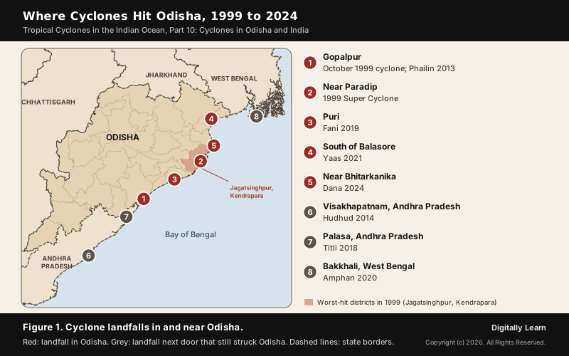
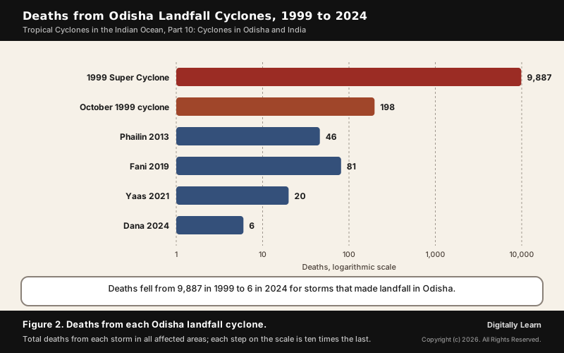
The list of cyclones in Odisha from 1999 to 2024 runs from the 1999 Odisha Super Cyclone, which killed 9,887 people by the India Meteorological Department's count, to Cyclone Dana in October 2024, which killed six. Odisha has the highest frequency of cyclones of any Indian coastal state. Its storms, together with Amphan in West Bengal, Tauktae and Biparjoy in Gujarat and the cyclones of the Tamil Nadu and Andhra coasts, are the major cyclones in India of the last twenty-five years. The fall in deaths came from forecasts, four-stage warnings and mass evacuation.
List of Cyclones in Odisha from 1999 to 2024 with Wind Speed
Odisha Cyclone List: Landfall, Wind Speed and Deaths
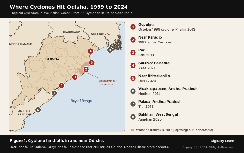
Odisha has faced a damaging cyclone almost every other year since 1999. The table lists the major storms that crossed the Odisha coast or struck the state from a neighbouring coast, with the peak wind speed on the IMD scale and the total death toll in all affected areas. Storms marked with another state made landfall there but still brought wind, rain or landslides to Odisha.
| Cyclone and year | Landfall and peak wind, then deaths and impact |
|---|---|
| October 1999 cyclone | Near Gopalpur, Odisha; 165 km/h. 198 deaths; struck eleven days before the super cyclone. |
| 1999 Odisha Super Cyclone | Near Paradip, 29 October 1999; 260 km/h. 9,887 deaths (IMD); 8,119 in Jagatsinghpur. |
| Phailin, 2013 | Near Gopalpur, 12 October; 215 km/h. 46 deaths; over 550,000 evacuated. |
| Hudhud, 2014 | Visakhapatnam, Andhra Pradesh; 185 km/h. 116 deaths in all; relief camps in Andhra Pradesh and Odisha. |
| Titli, 2018 | Near Palasa, Andhra Pradesh, 10 October; 150 km/h. 89 deaths, 77 of them in Odisha. |
| Fani, 2019 | Puri, 3 May; 215 km/h. 81 deaths in all; over 1.2 million evacuated in Odisha. |
| Bulbul, 2019 | West Bengal, 9 November; 140 km/h. Outer bands brought heavy rain and crop damage to Odisha. |
| Amphan, 2020 | Near Bakkhali, West Bengal, 20 May; peak 240 km/h. 133 deaths in all; 1,704 shelters opened in Odisha. |
| Yaas, 2021 | About 20 km south of Balasore, 26 May; 140 km/h. 20 deaths in India and Bangladesh. |
| Gulab, 2021 | North of Kalingapatnam, Andhra Pradesh, 26 September; 85 km/h. Outer rainbands reached south Odisha. |
| Jawad, 2021 | Weakened off the coast, December; 75 km/h. Odisha forecast to bear the most impact. |
| Dana, 2024 | Near Bhitarkanika, 24 October; 110 km/h. 6 deaths in all, 1 in Odisha; 362,000 evacuated. |
Why Odisha Is India's Most Cyclone-Prone Coast
India's long coastline, 8,041 kilometres by NDMA's figure, is exposed to nearly 10 per cent of the world's tropical cyclones. About five cyclones form in the North Indian Ocean in a year, and the Bay of Bengal produces about four for every one in the Arabian Sea. The season has two peaks, a primary peak in November and a secondary peak in May, which is why most storms in the table arrive in October, November or May.
Within the Bay of Bengal, IMD's own count puts the frequency of cyclones highest for Odisha and the frequency of severe cyclonic storms highest for Andhra Pradesh; on the west coast, Gujarat is the most vulnerable. NDMA's record for 1891 to 1990 shows the contrast: 262 cyclones, 92 of them severe, in a 50 km strip along the east coast, against 33 on the west coast, 19 of them severe.
- More storms in the Bay: Cyclones there form over the south-east Bay and the Andaman Sea, and some are remnants of Pacific typhoons that cross the South China Sea.
- Fewer in the Arabian Sea: Most Bay storms weaken over land before they can reach it, and its water is relatively colder, which holds back formation and intensification.
- Why the surge kills: Storm surge does the most damage. It is worst where the sea bed is shallow and the landfall coincides with high tide, and salt water left on the land spoils its fertility for years.
The same conditions explain why some tropical seas have almost no cyclones. NCERT lists what a storm needs: a large sea surface warmer than 27 degrees Celsius, the Coriolis force, little change of wind with height, a pre-existing low and divergence aloft. In the South Atlantic the Intertropical Convergence Zone drops only one to two degrees south of the equator, too close for the Coriolis force to help, and the water is cooler, so cyclones seldom form there.
Odisha Super Cyclone 1999: Landfall, Storm Surge and Death Toll
October 1999 Twin Cyclones: Gopalpur Storm and Paradip Super Cyclone
Odisha was hit twice in October 1999. The first storm, an extremely severe cyclonic storm, crossed the coast near Gopalpur in the south and killed 198 people. Eleven days later a far stronger storm struck the central coast, where the ground was already waterlogged.
The 1999 Odisha Super Cyclone crossed the coast near Paradip on 29 October 1999, on the stretch between Puri and Kendrapara. IMD estimated sustained winds of about 260 km/h and a central pressure of 912 hPa, and calls it the most intense cyclonic storm over the North Indian Ocean in the region's recorded history. It was also the largest cyclone of the basin between 1891 and 2007. Paradip recorded about 52 cm of rain in the 24 hours to 08:30 IST on 30 October.
Water, not wind, did most of the killing. A storm surge of 5 to 6 metres carried sea water up to 35 km inland; the Ministry of Urban Development put the peak surge at 6.7 metres. With the heavy rain it flooded the delta, damaged about 1.6 million homes and breached 20,005 flood embankments.
- Deaths: 9,887 by the IMD’s count, with 40 missing and 2,507 injured; other estimates ran as high as 30,000.
- Where people died: 8,119 of the deaths were in Jagatsinghpur district, and the blocks of Erasama and Kujang were the worst affected.
- Area affected: Twelve districts reported a complete breakdown of essential services, including Balasore, Bhadrak, Cuttack, Jagatsinghpur, Kendrapara, Khurda and Puri, and 12.9 million people were affected.
- Damage: The destruction was put at US$4.44 billion.
Cyclone Evacuation in Odisha: 1999 Compared with Later Storms
The difference between 1999 and later storms lies in preparation. Before the super cyclone, evacuation covered nearly 150,000 people living within 10 km of the coast in five districts, and six districts had 23 permanent cyclone shelters, run by the Indian Red Cross Society, which housed 30,000 evacuees. Later storms of comparable strength met a far larger effort:
- Phailin, 2013: The Odisha government and its disaster management agency, OSDMA, moved close to a million people to cyclone shelters.
- Fani, 2019: Over 1.2 million residents were moved to higher ground and to shelters built a few kilometres inland.
- Dana, 2024: Over 362,000 people from 1,653 villages were evacuated to 5,209 shelters.
Phailin, Fani and Dana: Odisha's Cyclone Preparedness Record
Cyclone Phailin 2013 and Cyclone Fani 2019 in Odisha
Phailin crossed the coast near Gopalpur on 12 October 2013 as an extremely severe cyclonic storm with winds of 215 km/h, close to the 1999 storm in strength. Officials expected around 12 million people to be affected. The storm prompted India's biggest evacuation in 23 years: more than 550,000 people were moved from the coast in Odisha and Andhra Pradesh, and the distant storm warning signal was raised at the ports of Paradip and Gopalpur.
Phailin killed 46 people in India, against 9,887 in 1999. The economic loss was still heavy, about ₹260 billion (US$4.26 billion), because evacuation saves lives but not houses, crops and power lines. That gap is why cyclone planning has to protect houses, crops and power lines as well as lives.
Six years later, Fani struck Puri on 3 May 2019 as an extremely severe cyclonic storm with winds of 215 km/h. It was a storm of the secondary May peak; IMD notes that May to June and October to November produce the most severe cyclones. The warnings followed IMD's stages in practice: a cyclone alert was issued 66 hours before landfall and a cyclone warning 36 hours before it.
The Odisha State Disaster Management Authority and the state government evacuated over 1.2 million residents and deployed about a thousand emergency workers and 43,000 volunteers. Fani killed at least 81 people in eastern India and Bangladesh and caused about US$8.1 billion of damage, mostly in Odisha, which shows that a well-warned storm can still be very costly.
Cyclone Dana 2024 and Odisha's Zero-Casualty Target
Dana, a severe cyclonic storm with winds of 110 km/h, made landfall near Bhitarkanika National Park on 24 October 2024 and weakened as it moved inland over northern Odisha. Before it arrived, the Chief Minister set a target of zero casualties for the state, and schools were closed in 14 districts of Odisha from 23 to 25 October. The target was nearly met, and the losses fell mainly on farms: UNICEF reported 180,000 hectares of standing crops ruined.
- Evacuation: Over 362,000 people across 1,653 villages in Odisha, and over 300,000 in West Bengal.
- Response forces: Twenty-five National Disaster Response Force teams, 11 in Odisha and 14 in West Bengal.
- Outcome: One death in Odisha, a woman in a storm shelter in Kendrapara district after a suspected cardiac arrest, and six in all, four of them in West Bengal.
- Damage in Odisha: About ₹6.16 billion (US$64 million), much of it to crops.
Titli, Hudhud, Yaas and Other Cyclones That Struck Odisha
Several storms that made landfall in a neighbouring state hit Odisha hard, because a cyclone's rain and wind spread far beyond its landfall point.
- Titli, 2018: It made landfall near Palasa in Andhra Pradesh, yet 77 of the 85 deaths in India were in Odisha. In Gajapati district a single landslide killed 12 people who had taken refuge in a cave.
- Hudhud, 2014: It crossed the coast at Visakhapatnam; across Andhra Pradesh and Odisha 730,000 people were moved to relief camps or shelters.
- Yaas, 2021: It crossed the northern Odisha coast about 20 km south of Balasore as a very severe cyclonic storm; West Bengal was the hardest-hit state, with losses of about ₹210 billion.
- Bulbul, Gulab and Jawad: Bulbul’s outer bands damaged crops and power lines in Odisha in 2019, Gulab’s rainbands reached south Odisha in 2021, and Jawad weakened at sea later that year after IMD forecast that Odisha would bear the most impact.
Major Cyclones in India Beyond Odisha, 1999 to 2024
Cyclone Amphan 2020: The Super Cyclone of the Ganges Delta
Amphan formed over exceptionally warm water, with sea surface temperatures of 32 to 34 degrees Celsius. On 17 May 2020 it underwent rapid intensification, becoming an extremely severe cyclonic storm within 12 hours, and it peaked as a super cyclonic storm at 240 km/h. It weakened before landfall near Bakkhali in West Bengal on 20 May but remained the strongest cyclone to strike the Ganges Delta.
Amphan killed 133 people and caused over US$15 billion of damage, making it the costliest cyclone recorded in the North Indian Ocean until Cyclone Senyar in 2025. It struck during the COVID-19 pandemic: shelters could be filled only to one-third of capacity, and West Bengal's shelter capacity fell from 500,000 people to 200,000. Odisha opened at least 1,704 shelters. The West Bengal government put its losses at ₹1.02 trillion and said the storm directly affected 70 per cent of the state's population.
Arabian Sea Cyclones: Tauktae 2021, Biparjoy 2023 and Nisarga
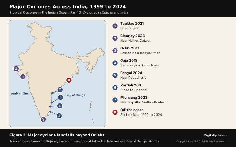
Cyclone Tauktae formed over Arabian Sea water of up to 30 degrees Celsius, moved north parallel to the coasts of Kerala, Karnataka, Goa and Maharashtra, and intensified rapidly into an extremely severe cyclonic storm of 185 km/h. It made landfall near Una in Gujarat in May 2021, the strongest cyclone to strike Gujarat since the 1998 Gujarat cyclone. At sea, Barge P305 sank near the Heera oil field off Mumbai: 66 people died and the Indian Navy rescued 186 of the 270 on board. Tauktae killed at least 174 people.
- Biparjoy, 2023: An extremely severe cyclonic storm with peak winds of 165 km/h that set the record for accumulated cyclone energy in the North Indian Ocean. It weakened before landfall near Naliya in Gujarat on 16 June; more than 150,000 people were evacuated and 12 died in India.
- Nisarga, 2020: It made landfall near Alibag, about 95 km south of Mumbai, on 3 June 2020, the strongest storm to strike Maharashtra in June since 1891.
Cyclones of Tamil Nadu and Andhra Pradesh: Vardah to Michaung
NCERT describes October and November as the rainiest months of the eastern Peninsula, when cyclonic depressions from the Andaman Sea cross the coast, and names the thickly populated deltas of the Godavari, Krishna and Kaveri as their preferred targets.
- Vardah, 2016: A very severe cyclonic storm with peak winds of 130 km/h that weakened before making landfall close to Chennai on 12 December; it killed 24 people in Tamil Nadu.
- Ockhi, 2017: It passed near Kanyakumari and on towards Lakshadweep with winds of 155 km/h, killing 218 people in India, many of them fishermen at sea.
- Gaja, 2018: It crossed the Tamil Nadu coast through Vedaranyam late on 15 November with winds of 130 km/h; 52 deaths were reported in Tamil Nadu.
- Michaung, 2023: It made landfall near Bapatla in Andhra Pradesh on 5 December with winds of 100 km/h, after its rain flooded Chennai; at least 17 people died.
List of Cyclones in India in 2024: Remal, Asna, Dana and Fengal
The 2024 North Indian Ocean season was an average one, with four cyclonic storms, of which two were severe. It was the second season in a row without a very severe cyclonic storm, the first time since 2012. All four cyclones of 2024 affected India:
- Remal, May: It made landfall over Bangladesh, and its rain caused landslides and a quarry collapse in Mizoram, where 34 people died.
- Asna, August: It formed as a deep depression over land and moved into the Arabian Sea; the floods it brought killed 49 people in Gujarat.
- Dana, October: The severe cyclonic storm that crossed the Odisha coast near Bhitarkanika.
- Fengal, November: It made landfall near Puducherry and killed 20 people in India, including 10 in Tiruvannamalai district of Tamil Nadu.
How Cyclones Are Classified and Named in India
IMD Cyclone Classification by Wind Speed
IMD grades every cyclonic disturbance in the Bay of Bengal and the Arabian Sea by its maximum sustained surface wind. A system becomes a cyclonic storm, and gets a name, at 34 knots (62 km/h). The top grade, the super cyclonic storm, starts at 120 knots (222 km/h), which the 1999 Odisha storm and Amphan reached.
| Category | Wind speed in knots | Wind speed in km/h |
|---|---|---|
| Depression | 17 to 27 | 31 to 49 |
| Deep depression | 28 to 33 | 50 to 61 |
| Cyclonic storm | 34 to 47 | 62 to 88 |
| Severe cyclonic storm | 48 to 63 | 89 to 117 |
| Very severe cyclonic storm | 64 to 89 | 118 to 166 |
| Extremely severe cyclonic storm | 90 to 119 | 167 to 221 |
| Super cyclonic storm | 120 and above | 222 and above |
The extremely severe grade was added to the scale in 2015. Damage rises much faster than wind speed: IMD notes that wind damage is roughly proportional to the cube of the wind speed.
How Cyclones Are Named: The North Indian Ocean Name List
Names help the public and the media follow a storm and make warnings reach people faster. The WMO/ESCAP Panel on Tropical Cyclones agreed in 2000, at Muscat, to name cyclones in the Bay of Bengal and the Arabian Sea, and naming began in September 2004 with Cyclone Onil. RSMC New Delhi, run by IMD, gives the name when a storm reaches 34 knots.
- Who proposes names: The first list had 64 names from eight countries. When five more countries joined, a new list was drawn up with 13 names from each of 13 members: Bangladesh, India, Iran, Maldives, Myanmar, Oman, Pakistan, Qatar, Saudi Arabia, Sri Lanka, Thailand, the United Arab Emirates and Yemen.
- What a name must be: Neutral to politics, religion, culture and gender, short and easy to pronounce, and no more than eight letters.
- How names are used: In order, column by column down the list, and never repeated; unlike the Atlantic lists, the North Indian Ocean list is not rotated.
- Storms from the east: A cyclone that crosses from the South China Sea into the Bay of Bengal keeps its original name.
Cyclone Warnings and Disaster Management in India
IMD Four-Stage Cyclone Warnings and Colour Codes
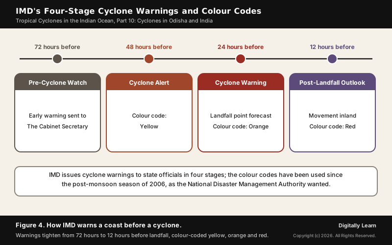
IMD issues cyclone warnings to state government officials in four stages, each tighter than the last. Since the post-monsoon season of 2006, at the request of the National Disaster Management Authority, the later stages carry colour codes so that officials and the public can read the danger at a glance:
- Pre-cyclone watch, 72 hours ahead: An early warning that a disturbance may become a cyclone, issued by the Director General of Meteorology and addressed to the Cabinet Secretary and the chief secretaries of the coastal states.
- Cyclone alert, at least 48 hours ahead (yellow): The storm’s position, intensity and likely direction, the coastal districts at risk and advice to fishermen.
- Cyclone warning, at least 24 hours ahead (orange): The landfall point is forecast, with updates every three hours on wind, rain and storm surge.
- Post-landfall outlook, at least 12 hours ahead (red): The likely track and weather inland after landfall.
Warnings reach people through state officials, All India Radio and Doordarshan, and ports hoist storm warning signals. Fishermen get special warnings four times a day in normal weather and every three hours when a storm is active. Fani showed the stages at work: the alert came 66 hours before landfall and the warning 36 hours before it.
Disaster Management Act 2005, NDMA and NDRF
The Disaster Management Act, 2005 (Act No. 53 of 2005) received the President's assent on 23 December 2005 and has 11 chapters and 79 sections. It is administered by the Ministry of Home Affairs and set up a three-level structure:
- National Disaster Management Authority (NDMA): Chaired by the Prime Minister, with up to nine members; it lays down policies, plans and guidelines. It began by executive order on 30 May 2005 and was constituted under the Act on 27 September 2006.
- National Executive Committee: Secretaries of the Union ministries under the Home Secretary, who prepare the National Disaster Management Plan.
- State Disaster Management Authorities: Each state has a State Disaster Management Authority chaired by the Chief Minister, which draws up the state plan.
- National Disaster Response Force (NDRF): Set up in 2006, 16 battalions drawn from the central armed police forces, stationed at 12 locations so that teams can be pre-positioned before a storm.
NDMA's stated vision is a holistic, pro-active and technology-driven strategy that fosters a culture of prevention, preparedness and mitigation. Internationally, India follows the Sendai Framework for Disaster Risk Reduction (2015 to 2030), whose seven targets include lower disaster mortality and wider access to multi-hazard early warning systems by 2030.
Sea Surface Temperature Rise and Rapid Intensification
The temperature of the ocean's top layer, the sea surface temperature, decides how much heat and moisture a cyclone can draw. A cyclone draws its energy from condensation in the towering clouds around its centre, and it keeps strengthening while the sea supplies moisture; over land that supply is cut off and the storm dies. That is why NCERT puts a sea surface warmer than 27 degrees Celsius first among the conditions for a cyclone.
- More energy: Warmer water gives more evaporation and more latent heat, so storms can reach higher intensity.
- Rapid intensification: Storms can strengthen suddenly, leaving less time to warn and evacuate. Amphan, over water of 32 to 34 degrees Celsius, went from a severe to an extremely severe storm within 12 hours; Tauktae and Biparjoy also intensified rapidly.
- New regions at risk: The Arabian Sea’s cooler water has limited its cyclones; as it warms, west coast states such as Gujarat face storms like Tauktae.
Previous Year UPSC-CSE Questions
Previous Year UPSC-CSE Questions By the end you will be able to draft model answers for the following UPSC questions. Each question carries a collapsible framework showing how to approach it in the exam.
- UPSC Mains 2022 GS-IDiscuss the meaning of colour-coded weather warnings for cyclone prone areas given by India Meteorological Department.
How to structure the answer in the exam
Introduction: Open with IMD's four-stage cyclone warning and the colour codes used since the post-monsoon season of 2006 at NDMA's request.
Body (sub-themes to develop):
- Pre-cyclone watch 72 hours ahead, from the Director General of Meteorology to the Cabinet Secretary.
- Yellow cyclone alert at least 48 hours ahead: position, intensity, districts at risk, advice to fishermen.
- Orange cyclone warning at least 24 hours ahead: landfall point, three-hourly updates on wind, rain and surge.
- Red post-landfall outlook at least 12 hours ahead: the track and weather inland.
- Use: Fani 2019 alert 66 hours and warning 36 hours before landfall, with 1.2 million evacuated.
Conclusion: Conclude that colour codes turn a technical forecast into a clear action signal, which is why deaths fell from 1999 to Dana.
- UPSC Mains 2020 GS-IIIDiscuss the recent measures initiated in disaster management by the Government of India departing from the earlier reactive approach.
How to structure the answer in the exam
Introduction: Open with the contrast: in 1999 about 150,000 were evacuated and 9,887 died; in 2024 Dana killed six.
Body (sub-themes to develop):
- Law and institutions: Disaster Management Act 2005, NDMA under the Prime Minister, SDMAs, the National Executive Committee.
- Response capacity: NDRF with 16 battalions at 12 locations, pre-positioned before storms.
- Early warning: IMD four-stage colour-coded warnings, port signals and fishermen's bulletins.
- Preparedness on the ground: shelters and mass evacuation, Phailin, Fani and Dana's zero-casualty target.
- International frame: the Sendai Framework's targets on mortality and early warning.
Conclusion: Conclude that deaths have fallen sharply but damage has not, so the next step is resilient housing, power and livelihoods.
- UPSC Mains 2024 GS-IWhat is sea surface temperature rise? How does it affect the formation of tropical cyclones?
How to structure the answer in the exam
Introduction: Define sea surface temperature as the temperature of the ocean's top layer, and state that cyclones need water warmer than 27 degrees Celsius.
Body (sub-themes to develop):
- Energy: warmer water means more evaporation and latent heat released in the storm's clouds.
- Rapid intensification: Amphan became extremely severe within 12 hours over water of 32 to 34 degrees Celsius.
- Arabian Sea: its cooler water limited cyclones; Tauktae formed over water of up to 30 degrees Celsius.
- Consequence: less warning time and stronger storms at landfall.
Conclusion: Conclude that warming seas make forecasting and preparedness more urgent on both coasts.
- UPSC Prelims 2015 Prelims-GSIn the South Atlantic and South-Eastern Pacific regions in tropical latitudes, cyclone does not originate. What is the reason?
How to approach this Prelims question
Approach: Ask which condition for cyclone formation is missing in these seas.
Trap to watch: The Coriolis force exists there; the problem is that the ITCZ stays too close to the equator for it to help.
Key facts to recall:
- The ITCZ drops only one to two degrees south of the equator in the South Atlantic
- Cyclones need warm water, Coriolis force, low wind shear and a pre-existing low
Answer signal: The Inter-Tropical Convergence Zone seldom occurs there, option (b).
Sources
- Wikipedia: 1999 Odisha cyclone
- Wikipedia: 1999 North Indian Ocean cyclone season
- Wikipedia: Cyclone Phailin
- Wikipedia: Cyclone Hudhud
- Wikipedia: Cyclone Titli
- Wikipedia: Cyclone Fani
- Wikipedia: Cyclone Bulbul
- Wikipedia: Cyclone Amphan
- Wikipedia: Cyclone Yaas
- Wikipedia: Cyclone Gulab
- Wikipedia: Cyclone Jawad
- Wikipedia: Cyclone Dana
- Wikipedia: Cyclone Montha
- Wikipedia: Cyclone Tauktae
- Wikipedia: Cyclone Biparjoy
- Wikipedia: Cyclone Nisarga
- Wikipedia: Cyclone Vardah
- Wikipedia: Cyclone Ockhi
- Wikipedia: Cyclone Gaja
- Wikipedia: Cyclone Michaung
- Wikipedia: Cyclone Remal
- Wikipedia: Cyclone Asna
- Wikipedia: Cyclone Fengal
- Wikipedia: 2024 North Indian Ocean cyclone season
- Wikipedia: 2025 North Indian Ocean cyclone season
- Wikipedia: North Indian Ocean tropical cyclone
- Wikipedia: South Atlantic tropical cyclone
- Wikipedia: Disaster Management Act 2005
- Wikipedia: National Disaster Response Force
- Wikipedia: Sendai Framework for Disaster Risk Reduction
- IMD RSMC New Delhi: Four Stage Warning
- IMD RSMC New Delhi: Naming of Tropical Cyclones over the North Indian Ocean
- IMD RSMC New Delhi: Terminology on Cyclonic Disturbances
- IMD RSMC New Delhi: Frequently Asked Questions on Tropical Cyclones
- NDMA: Cyclone
- India Code: The Disaster Management Act, 2005
- NCERT: Fundamentals of Physical Geography (Class XI), Atmospheric Circulation and Weather Systems
- NCERT: India Physical Environment (Class XI), Climate and Natural Hazards and Disasters
- UPSC: Civil Services (Preliminary) Examination 2015 and Mains question papers
Disclaimer
This article is prepared for UPSC aspirants and covers eight canonical Indian cyclone case studies across the modern post-Disaster-Management-Act era. Content is based on NCERT Class 11 Geography Chapter 7 cross-verified against authoritative primary sources like IMD and Wikipedia. Readers seeking real-time cyclone bulletins should consult the IMD RSMC New Delhi portal.