


Overview
Course, tributaries, dams and the water disputes
Two east-flowing rivers of the south and the disputes over their water.
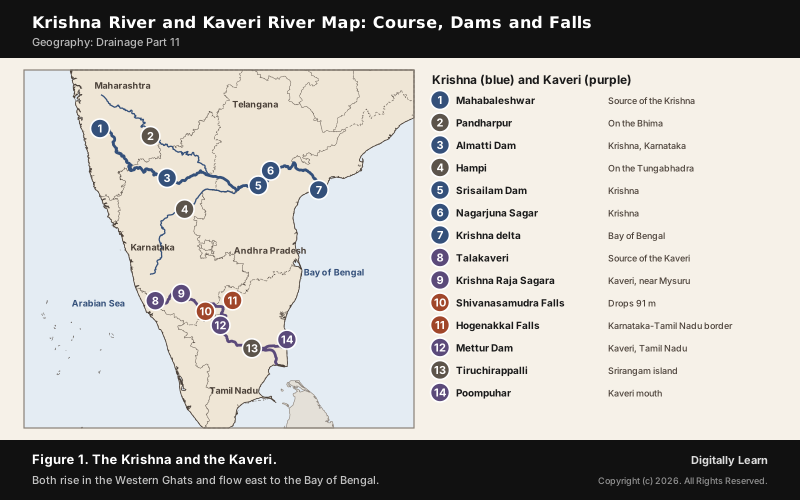
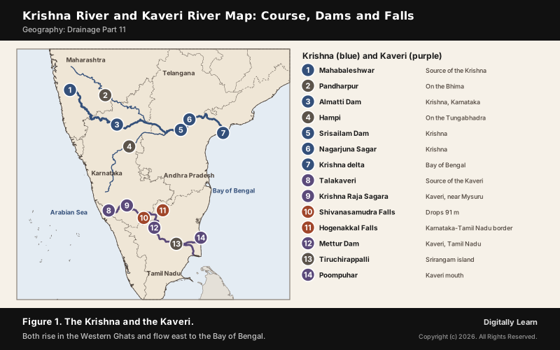
The Kaveri river rises at Talakaveri in the Brahmagiri hills of Karnataka and flows 800 km to the Bay of Bengal; the Krishna river rises near Mahabaleshwar in Maharashtra and flows 1,401 km, the second largest east-flowing river of the Peninsula. Both are shared by several states, and the Cauvery water dispute and the Krishna dispute are India's best-known inter-state water disputes.
Kaveri River and Krishna River: Two East-Flowing Rivers of the South
Kaveri River and Krishna River Compared: Map, Origin and Basin
Both rivers rise in the Western Ghats and flow east across the Deccan to the Bay of Bengal, building deltas at their mouths. The Krishna is the longer and larger; the Kaveri is the more reliable, carrying water all year.
| Feature | Krishna | Kaveri |
|---|---|---|
| Length | 1,401 km | 800 km |
| Basin share | Maharashtra 27, Karnataka 44, Andhra Pradesh 29 per cent | Kerala 3, Karnataka 41, Tamil Nadu 56 per cent |
| Main tributaries | Koyna, Tungabhadra, Bhima | Kabini, Bhavani, Amaravati |
| Mouth | Delta on the Andhra Pradesh coast | Near Poompuhar, Tamil Nadu |
The Mahanadi and Godavari, the other east-flowing rivers, are covered in Drainage Part 10, and the west-flowing rivers in Drainage Part 12.
Krishna River: Origin, Course, Tributaries and Dams
Krishna River Origin and Course: Which States It Flows Through
The Krishna river rises near Mahabaleshwar in the Sahyadri, at about 1,300 m, and flows east for 1,401 km to the Bay of Bengal. It is the second largest east-flowing river of the Peninsula and the third-longest river in India, after the Ganga and the Godavari.
- States: Maharashtra, Karnataka, Telangana and Andhra Pradesh; of its catchment, 27 per cent lies in Maharashtra, 44 per cent in Karnataka and 29 per cent in Andhra Pradesh.
- Basin: About 258,948 square km, nearly 8 per cent of India’s area, the fifth-largest basin in the country.
- Delta: The Krishna-Godavari delta is known as the rice granary of India; Kolleru Lake lies between the two deltas.
- Linking: Since 2015 the Pattiseema lift scheme sends Godavari water to the Krishna through the Polavaram right bank canal, to the Prakasam Barrage.
- Water and land: The basin has black, red and laterite soils and an average surface water potential of 78.1 cubic km, of which 58.0 is usable; its culturable area is 10.4 per cent of India’s.
- Minerals: The basin holds oil and gas, coal, iron, limestone, dolomite, gold, uranium and diamonds.
- Mangroves: The last surviving mangroves of the Krishna estuary are protected as the Krishna Wildlife Sanctuary.
Krishna River Tributaries and Dams: Bhima, Tungabhadra and Nagarjuna Sagar
The Krishna has 13 major tributaries. The Koyna, the Tungabhadra and the Bhima are the most important; the Ghataprabha, Malaprabha and Musi also join it.
- Bhima: The longest tributary, 861 km; at Pandharpur it is called the Chandrabhaga.
- Tungabhadra: 531 km long, with a catchment of 71,417 square km; the ruins of Hampi, the Vijayanagara capital, stand near it.
- Almatti Dam: The main reservoir of the Upper Krishna Irrigation Project in north Karnataka, completed in 2005.
- Srisailam Dam: A gravity Krishna river dam near its confluence with the Tungabhadra in the Nallamala Hills; its power station is India’s second largest by capacity.
- Nagarjuna Sagar: A masonry dam on the Krishna on the Telangana-Andhra Pradesh border, built between 1955 and 1967; it was the first of the ‘modern temples’ begun for the Green Revolution and is run jointly by the two states.
- Kudalasangama: The Krishna meets the Malaprabha here, about 15 km from the Almatti Dam.
Kaveri River: Origin, Course, Tributaries and Dams
Kaveri River Origin and Course: Talakaveri to Poompuhar
The Kaveri river rises at Talakaveri in the Brahmagiri hills of Kodagu, Karnataka, at 1,341 m. It is 800 km long and drains 81,155 square km: 3 per cent of the basin lies in Kerala, 41 per cent in Karnataka and 56 per cent in Tamil Nadu.
- Upper course: It enters the Deccan through a narrow gorge, dropping 18 to 24 m at the Chunchanakatte Falls.
- In Karnataka: After about 320 km it forms the island of Srirangapatna, drops 91 m at the Shivanasamudra Falls, one of the largest waterfalls in the country, and passes through the Mekedatu gorge.
- The border: It forms the Karnataka-Tamil Nadu border for about 64 km, then enters Tamil Nadu at the Hogenakkal Falls.
- In Tamil Nadu: It reaches the Mettur Dam, is joined by the Bhavani at Kooduthurai, splits near Tiruchirappalli into the Kollidam and the Kaveri around the island of Srirangam, and fans into 36 distributaries.
- Mouth: It enters the Bay of Bengal near Poompuhar; in Tamil it is called Ponni and in Sanskrit Dakshina Ganga.
- History: The Kaveri supported the Chola and Pandya kingdoms, and it is revered as one of seven sacred rivers.
Kaveri River Tributaries, Dams and Its Two Monsoons
The Kaveri has 21 major tributaries, among them the Harangi, Hemavati, Kabini, Shimsha, Arkavati, Bhavani, Noyyal and Amaravati. Its unusual rainfall keeps it flowing more steadily, more perennial, than other Peninsular rivers.
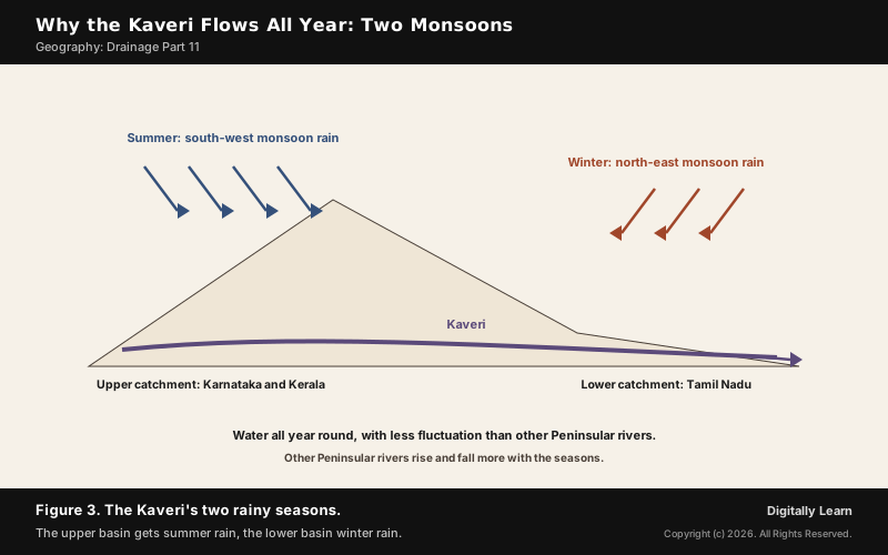
- Two monsoons: The upper catchment gets rain in the south-west monsoon (summer) and the lower catchment in the north-east monsoon (winter), so the river flows all year with less fluctuation than other Peninsular rivers.
- Krishna Raja Sagara: A Kaveri river dam near Mysuru, opened in 1932.
- Mettur Dam: Built in 1934 where the Kaveri enters the plains; the largest dam in Tamil Nadu.
- Kallanai: The Grand Anicut, built across the Kaveri by the Chola king Karikala in 150 CE.
- Protected areas: Nagarhole lies by the Kabini reservoir, Sathyamangalam by the Moyar and Bhavani, and the Kabini flows through Wayanad.
Krishna and Cauvery Water Disputes and Tribunals
Article 262 and Inter-State Water Disputes Tribunals
Inter-state rivers need a way to share water fairly. Article 262 of the Constitution lets Parliament provide by law for settling disputes over inter-state rivers, and also bar the Supreme Court and other courts from hearing them.
- Inter-State River Water Disputes Act, 1956: When a dispute cannot be settled by negotiation, the Centre sets up an ad hoc tribunal; its decision is final and binding.
- River Boards Act, 1956: Provides for river boards to advise the states on developing inter-state rivers.
- Reform: The Inter-State River Water Disputes (Amendment) Bill, 2017 proposes a single standing tribunal with benches, and a Dispute Resolution Committee to try settlement within a year and a half.
River linking and the wider water disputes of India are covered in Drainage Part 14, on drainage and the economy.
Cauvery Water Dispute: Tribunal, 2018 Verdict and the CWMA
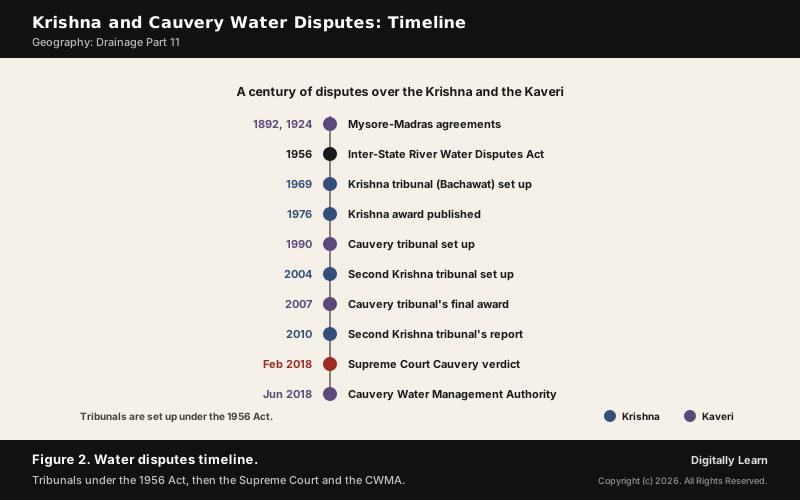
The Cauvery water dispute between Karnataka and Tamil Nadu goes back to agreements of 1892 and 1924 between Mysore and the Madras Presidency. After decades of failed talks, the Supreme Court in 1990 directed the Centre to set up the Cauvery Water Disputes Tribunal.
| Party | Tribunal award, 2007 | Supreme Court, 2018 |
|---|---|---|
| Tamil Nadu | 419 tmcft | 404.25 tmcft |
| Karnataka | 270 tmcft | 284.75 tmcft |
| Kerala | 30 tmcft | 30 tmcft |
| Puducherry | 7 tmcft | 7 tmcft |
- Award: The tribunal gave an interim award in June 1991 and its final award on 5 February 2007, published only in 2013.
- Verdict: On 16 February 2018 the Supreme Court raised Karnataka’s share and cut Tamil Nadu’s; the tribunal’s award merged with the judgement, and the tribunal was dissolved on 16 July 2018.
- CWMA: The Cauvery Water Management Authority was created on 1 June 2018 to implement the verdict, with the Cauvery Water Regulation Committee three weeks later.
- Still contested: In a dry August 2023 Tamil Nadu sought 24,000 cusecs a day and Karnataka refused, citing shortage; the CWMA directed 5,000 cusecs a day for 15 days, and protests broke out in both states.
Krishna Water Dispute: Bachawat and Brijesh Kumar Tribunals
The Krishna water dispute involves Maharashtra, Karnataka and Andhra Pradesh, and now Telangana. It has gone through two tribunals under the 1956 Act.
- First tribunal (Bachawat): Set up in April 1969; at 75 per cent dependability it found 2,060 TMC available and divided it among the three states; its award was gazetted on 31 May 1976.
- Second tribunal (Brijesh Kumar): Set up in April 2004; its report of 31 December 2010, at 65 per cent dependability, gave Andhra Pradesh 1,001 TMC, Karnataka 911 and Maharashtra 666; a further report followed on 29 November 2013.
- Still open: A Supreme Court order of 16 September 2011 stopped the second award’s publication, and the tribunal’s term was extended to address the Andhra Pradesh Reorganisation Act, 2014, which created Telangana.
Previous Year UPSC-CSE Questions
Previous Year UPSC-CSE Questions By the end you will be able to draft model answers for the following UPSC questions. Each question carries a collapsible framework showing how to approach it in the exam.
- UPSC Prelims 2020 Prelims-GSWhich of the following Protected Areas are located in Cauvery basin ?
- Nagarhole National Park
- Papikonda National Park
- Sathyamangalam Tiger Reserve
- Wayanad Wildlife Sanctuary
Select the correct answer using the code given below :
How to approach this Prelims question
Approach: Tie each protected area to the river beside it, then to the basin.
Trap to watch: Papikonda is in the Godavari basin.
Key facts to recall:
- Kabini and Bhavani are Kaveri tributaries
- Papikonda: Godavari districts
Answer signal: 1, 3 and 4 only, option (c).
- UPSC Prelims 2019 Prelims-GSConsider the following pairs: Famous place – River
- Pandharpur : Chandrabhaga
- Tiruchirappalli : Cauvery
- Hampi : Malaprabha
Which of the pairs given above are correctly matched?
How to approach this Prelims question
Approach: Place each town on its river before reading the options.
Trap to watch: Hampi is on the Tungabhadra, not the Malaprabha.
Key facts to recall:
- Bhima is called the Chandrabhaga at Pandharpur
- Tiruchirappalli: Kaveri
Answer signal: 1 and 2 only, option (a).
- UPSC Prelims 2008 Prelims-GSWhich of the following pairs are correctly matched? Waterfalls – River
- Kapildhara Falls : Godavari
- Jog Falls : Sharavati
- Sivasamudram Falls : Cauvery
Select the correct answer using the code given below:
How to approach this Prelims question
Approach: Recall the river of each waterfall.
Trap to watch: Kapildhara falls are near the Narmada's source at Amarkantak.
Key facts to recall:
- Jog: Sharavati
- Shivanasamudra: Kaveri
Answer signal: 2 and 3 only, option (b).
- UPSC Mains 2018 GS-IIHow far do you agree with the view that tribunals curtail the jurisdiction of ordinary courts? In view of the above, discuss the constitutional validity and competency of the tribunals in India.
How to structure the answer in the exam
Introduction: Open with why tribunals exist: specialised, faster adjudication outside the regular courts.
Body (sub-themes to develop):
- Article 262 lets Parliament bar the Supreme Court and other courts from water disputes.
- The 1956 Act makes tribunal decisions final and binding.
- Yet the Supreme Court heard appeals on the Cauvery award and its 2018 judgement absorbed it.
- Delays in the Krishna and Cauvery tribunals show the limits of ad hoc tribunals.
Conclusion: Conclude that tribunals supplement rather than replace courts, and that reforms such as a standing tribunal aim at speed without losing judicial oversight.
Sources
- NCERT: India Physical Environment (Class XI), Drainage System
- PIB (MoWR): Single Tribunal for Inter-State River Water sharing disputes, 9 August 2018
- PIB (MoWR): Interstate River Water Disputes, 17 July 2014
- Central Water Commission: Reports of Tribunals and Orders of the Supreme Court
- Jal Shakti (DoWR): Cauvery Water Management Authority
- Wikipedia: Krishna River
- Wikipedia: Kaveri
- Wikipedia: Kaveri River water dispute
- Wikipedia: Krishna Water Disputes Tribunal
- Wikipedia: Bhima River
- Wikipedia: Tungabhadra River
- Wikipedia: Srisailam Dam
- Wikipedia: Nagarjuna Sagar Dam
- Wikipedia: Mettur Dam
- Wikipedia: Kallanai
- UPSC: Civil Services Examination question papers
Disclaimer
This article draws on the NCERT geography textbooks, the Ministry of Water Resources through the Press Information Bureau, the Central Water Commission and the other sources listed on this page. River lengths and basin areas differ slightly between sources.