

Overview
Thermocline, halocline, the global conveyor belt and the AMOC
How temperature and salt move the deep ocean.
Thermohaline circulation is the slow, deep-ocean circulation driven by differences in the density of seawater, which is set by its temperature (thermo) and its salt content (haline). Cold, salty water is dense and sinks near the poles, spreads through the deep ocean and rises again far away, forming the global conveyor belt that carries heat, salt, nutrients and carbon round the world.
Thermohaline Circulation: Meaning and What Drives It
What Is Thermohaline Circulation: The Global Conveyor Belt
Thermohaline circulation is the part of the ocean's circulation that is driven by density, not by wind. Winds drive currents only in the upper 100 metres of the ocean, yet currents also flow thousands of metres below the surface. These deep currents move because seawater of different temperature and salinity has different density, and denser water sinks beneath lighter water.
The same system goes by two other names. Climate scientist Wallace Smith Broecker coined the term global conveyor belt, and it is also called the meridional overturning circulation (MOC). It has two major limbs: the Atlantic meridional overturning circulation (AMOC) in the North Atlantic and the Southern Ocean overturning circulation near Antarctica.
- Surface currents: They carry about 10 per cent of all ocean water, in the upper 400 m.
- Deep water currents: They make up the other 90 per cent and move round the ocean basins through differences in density and gravity.
- Where deep water starts: Deep waters sink into the deep ocean basins at high latitudes, where temperatures are cold enough to raise their density.
Salinity itself, its sources and its surface pattern are covered in Ocean Salinity Part 1.
Density of Seawater: Why Cold and Salty Water Sinks
Two properties decide whether a parcel of seawater sinks or floats. Water with high salinity is denser than water with low salinity, and cold water is denser than warm water. Denser water tends to sink, while lighter water tends to rise, so the coldest and saltiest water ends up at the bottom of the ocean.
- Temperature: Water becomes less dense as it warms, because the distance between its molecules increases.
- Salinity: Water becomes denser as salinity rises, since more salt is dissolved in the same volume.
- Freezing: Fresh water is densest at 4 °C, but seawater keeps getting denser as it cools, right down to its freezing point, which can be below −2 °C.
- Pressure: It matters little, because seawater is almost incompressible.
Surface salinity changes in both directions. It rises when water is lost to evaporation or to sea ice, and it falls when fresh water arrives from rain, rivers or melting ice. A sea that is both cooling and growing saltier becomes dense enough to sink, which is why deep water forms only in a few cold places.
Types of Ocean Currents: Wind-Driven Surface Currents and Thermohaline Currents
Ocean currents are like rivers in the ocean: a regular volume of water moving along a definite path. The primary forces that set them moving are heating by the sun, wind, gravity and the Coriolis force. Heating makes water expand, so the ocean near the equator stands about 8 cm higher than in the middle latitudes and water flows down this slight slope.
- Wind: Wind blowing on the surface pushes the water, and friction between wind and water drives the flow.
- Gravity: It pulls the water down to pile up and creates differences in slope.
- Coriolis force: It turns moving water to the right in the northern hemisphere and to the left in the southern hemisphere, producing large circular currents called gyres.
- Density: Differences in density affect the vertical movement of currents; this is the thermohaline part.
| Feature | Surface currents | Deep currents |
|---|---|---|
| Driven by | Wind and the Coriolis force | Density, set by temperature and salinity |
| Depth | Upper 400 m, about 10 per cent of ocean water | Deep ocean, about 90 per cent of ocean water |
| Speed | Tens to hundreds of centimetres a second | A few centimetres a second |
| Examples | Gulf Stream, Labrador Current | North Atlantic Deep Water, Antarctic Bottom Water |
Ocean Stratification: Thermocline, Halocline and Pycnocline
Layers of the Ocean: Mixed Layer, Thermocline and Deep Water
Temperature does not fall evenly with depth. In the low and middle latitudes the ocean behaves as a three-layer system: warm water on top, a band where temperature drops sharply, and cold water below. The band of rapid change is the thermocline.
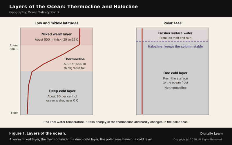
- Top layer: Warm water about 500 m thick, at 20 to 25 °C. In the tropics it is present all year; in the middle latitudes it develops only in summer.
- Thermocline: The second layer, 500 to 1,000 m thick, where temperature falls rapidly with depth.
- Deep layer: Very cold water reaching down to the ocean floor. About 90 per cent of the ocean’s water lies below the thermocline, at temperatures approaching 0 °C.
- Polar seas: Surface water is close to 0 °C, so there is only one cold layer from the surface to the floor and temperature changes very little with depth.
The top layer is also called the mixed layer, because wind, waves and surface cooling stir it until its temperature is nearly uniform. The ocean is warmest at the surface, where its average temperature is about 27 °C, and cools towards the poles and towards the floor.
What Is Thermocline: Meaning, Depth and Uses
A thermocline is the transition layer between the warmer mixed water at the ocean's surface and the cooler deep water below. It is easy to tell when a diver or an instrument reaches it, because the temperature drops suddenly. In lakes the same layer is called the metalimnion.
- By latitude: The thermocline is semi-permanent in the tropics, variable in temperate regions and shallow to non-existent in the polar regions, where the water is cold from top to bottom.
- Over time: Its depth and strength vary from season to season and year to year.
- Sound: The sudden change in density reflects sonar signals, which makes the thermocline important in submarine warfare.
- Cyclones: Forecasters look at the depth of warm water above the thermocline, not just the sea surface temperature; it measures the size of a storm’s fuel tank.
That last point links the ocean's layers to the weather. How tropical cyclones draw on this warm water, and how salinity layers in the Bay of Bengal keep it warm, is taken up in Ocean Salinity Part 3.
What Is Halocline: Meaning and Difference from Thermocline
A halocline is a layer in a body of water where salinity changes sharply with depth. Salinity at depth hardly changes, because no water is lost and no salt is added there, while the surface gains salt through evaporation and loses it through rain and rivers. Salinity generally increases with depth, and the zone where it rises sharply is the halocline.
- Where it forms: Most commonly where fresh water from rivers or melting ice mixes with salty ocean water: estuaries, fjords and the polar seas.
- Depth: In the Arctic Ocean the halocline lies between 50 and 250 m deep; in shallow seas such as the Baltic it is at 60 to 80 m.
- Role in the polar seas: There the surface water is colder than the deep water, so it is the halocline that keeps the water column stable. It also allows sea ice to form and limits the escape of carbon dioxide to the air.
| Layer | What changes sharply with depth | Where it matters most |
|---|---|---|
| Thermocline | Temperature | Tropics and middle latitudes; absent in the polar seas |
| Halocline | Salinity | Polar seas, estuaries and river mouths |
| Pycnocline | Density | Below the mixed layer everywhere |
Pycnocline and Why Ocean Stratification Blocks Mixing
Because density depends on both temperature and salinity, the layer where density changes fastest is called the pycnocline. In the low and middle latitudes a permanent pycnocline lies between 200 and 1,000 m and follows the thermocline. In the subpolar and polar seas there is no permanent thermocline, and the halocline sets the pycnocline instead.
This layering is called ocean stratification: the natural separation of the ocean's water into horizontal layers by density. It is usually stable, because warm water floats on cold water and the sun heats the ocean from above. Wind mixing weakens it; convection, warm water rising and cold water sinking, reinforces it.
- A barrier: The pycnocline acts as a barrier to vertical circulation, limiting the exchange of heat, carbon, oxygen and nutrients between the surface and the deep.
- Nutrients: It keeps the nutrients of the deep water from reaching the sunlit layer where phytoplankton grow.
- Which property rules: In the tropics and middle latitudes surface density follows temperature; above about 50 degrees of latitude it follows salinity, because the water is already near freezing.
Deep Water Formation in the Polar Seas
North Atlantic Deep Water: Where and Why It Sinks
The conveyor gets its start in the Norwegian Sea. Warm water brought north by the Gulf Stream gives up its heat to the cold air of the northern latitudes, becomes cooler and denser, and sinks to the bottom of the ocean. As more warm water arrives from the south, the sinking water moves away southward to make room for it.
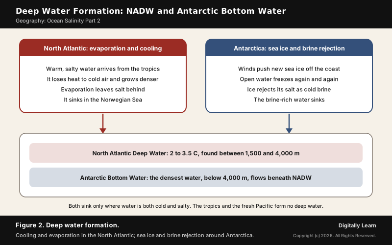
- Why the North Atlantic is salty: It is a rare part of the ocean where evaporation outweighs precipitation, partly because it is so windy. Moisture evaporated from the Atlantic is also carried by the trade winds across Central America and falls as rain in the Pacific, and mountain ranges stop it coming back.
- Where it goes: The sinking water fills the Arctic basin and spills south over the Greenland-Scotland Ridge. It cannot flow into the Pacific because the Bering Strait is too shallow.
- Its signature: North Atlantic Deep Water (NADW) has a temperature of 2.0 to 3.5 °C and lies between 1,500 and 4,000 m.
The shape of the ocean floor steers these deep flows. Ridges, sills, gaps and straits decide where dense water can pass, which is why a Prelims statement that ocean currents are affected by the configuration of the ocean floor is correct. NADW is one of several water masses; Ocean Salinity Part 6 covers them in detail.
Antarctic Bottom Water and Brine Rejection
The densest water in the ocean forms around Antarctica. Antarctic Bottom Water (AABW) is made in the Weddell and Ross Seas, off the Adélie Coast and by Cape Darnley. Strong winds blowing off the continent push newly formed sea ice away from the coast, leaving stretches of open water that freeze again, and each round of freezing makes the water saltier through brine rejection.
- Temperature: AABW ranges from −0.8 to 2 °C.
- Depth: As the densest water mass, it occupies the depths below 4,000 m in every ocean basin connected to the Southern Ocean, and flows beneath NADW.
- Where it spreads: AABW formed in the Weddell Sea mainly fills the Atlantic and Indian basins; AABW from the Ross Sea flows towards the Pacific.
- Oxygen: Because it forms at the surface it is rich in oxygen, and its sinking ventilates the deep ocean.
Climate change is already slowing this engine. The melting of the Antarctic ice sheet has slowed the formation of AABW, the slowdown is likely to continue, and a complete shutdown is possible as soon as 2050. Fresh meltwater is lighter than brine, so it resists sinking and weakens the overturning.
Why Deep Water Forms Only in the High Latitudes
Deep water needs two things at once: water that is cold and water that is salty. Tropical water is salty but warm, so it floats. The Pacific receives so much rain that its surface water is not saline enough to sink more than several hundred metres, so the deep water of the Pacific has to come from elsewhere.
- North Atlantic: Cold and salty, so it sinks as NADW.
- Antarctic margins: The coldest water, made saltier by brine rejection, sinks as AABW.
- Antarctic Intermediate Water: It forms at the Antarctic Polar Front, between 50 and 60 degrees south, and sinks despite its low salinity; its salinity minimum is found at 700 to 1,200 m.
- Mediterranean outflow: Evaporation makes Mediterranean water warm and saline; it leaves through the Strait of Gibraltar as an undercurrent and spreads through the North Atlantic at 1,000 to 1,200 m as the Mediterranean Salt Tongue.
Global Conveyor Belt: Path, Speed and Importance
Global Conveyor Belt Path from the North Atlantic to the Pacific
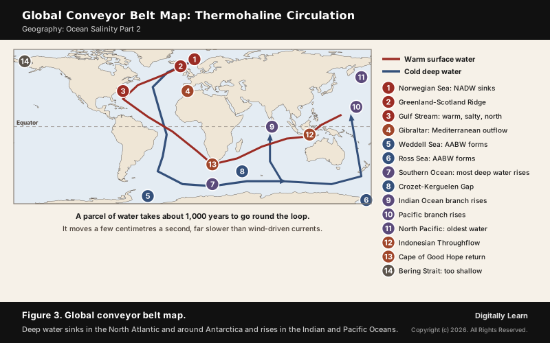
The global conveyor belt links every ocean basin in one loop. Its path is easiest to follow as a sequence, starting where the water first sinks.
- Sinking: Near the pole in the North Atlantic, water is chilled and made saltier by freezing sea ice, and it sinks towards the ocean bottom.
- Southward flow: The deep water moves south between the continents, past the equator, down to the ends of Africa and South America.
- Recharge: It travels round the edge of Antarctica, where water cools and sinks again, as it does in the North Atlantic.
- Branching: Two sections split off and turn north, one into the Indian Ocean and the other into the Pacific.
- Upwelling: The branches warm up, become less dense and rise to the surface as they travel towards the equator.
- Return: The surface water loops back south and west to the South Atlantic and finally returns to the North Atlantic, where the cycle begins again.
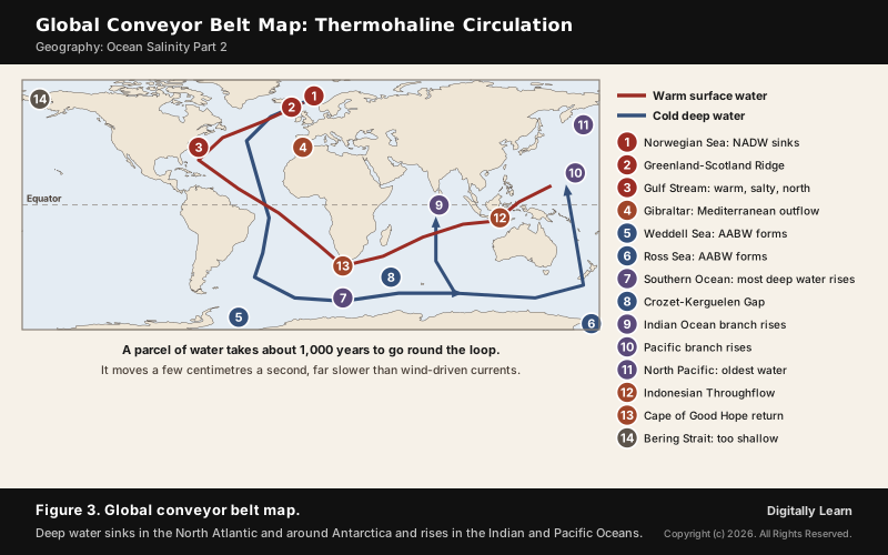
Most of the deep water rises in the Southern Ocean, but the oldest water, about 1,000 years in transit, rises in the North Pacific. Warmer, fresher surface water from the tropical Pacific flows into the Indian Ocean through the Indonesian archipelago and on towards the Atlantic.
Speed, Volume and Role in Heat, Nutrients and Carbon
The conveyor is very slow but very large. It moves at a few centimetres a second, against tens to hundreds of centimetres a second for wind-driven or tidal currents, and any given cubic metre of water takes about 1,000 years to complete the journey. It still moves more than 100 times the flow of the Amazon River.
- Heat: It supplies heat to the polar regions and so helps regulate the amount of sea ice there, although outside the tropics the atmosphere carries more heat towards the poles than the ocean does.
- Nutrients and carbon: Warm surface waters are poor in nutrients and carbon dioxide; they are enriched again as they travel in the deep layers. The base of the world’s food chain depends on the cool, nutrient-rich water that returns to the surface.
- Climate of the North Atlantic: Without the heat it carries, the climate round the North Atlantic, in Europe, North America and North Africa, would likely be much colder.
- Past shocks: Large floods of meltwater from Lake Agassiz at the end of the last ice age are thought to have shifted deep-water formation and caused the cold period in Europe known as the Younger Dryas.
Ocean Currents, Water Masses, Marine Life and Fishing Grounds
Ocean currents shape coastal climate. Warm currents raise the temperature of cold areas and cold currents lower it in warm ones: the Gulf Stream warms the east coast of North America and the west coast of Europe, while the Labrador Current cools the north-east coast of North America.
- Cool west coasts: West coasts in tropical and subtropical latitudes are bordered by cool water; they have low temperatures with narrow ranges, fog, and generally arid conditions.
- Mild west coasts higher up: West coasts in the middle and higher latitudes are bordered by warm water, giving a marine climate with cool summers and mild winters.
- Warm east coasts: Warm currents along east coasts in the tropics and subtropics bring warm, rainy climates.
- Fishing grounds: Where warm and cold currents mix, oxygen is replenished and plankton, the primary food of fish, grow well. The best fishing grounds lie mainly in these mixing zones.
- Upwelling: Winds blowing from land drive warm surface water away from the coast, and cold water rises from below; the Canary and Benguela Currents off Africa have strong upwelling.
- Navigation and safety: Ships use real-time and forecast currents to dock, manoeuvre in narrow waterways and navigate coastal waters safely; the speed of a current, its drift, is measured in knots. Rescue teams use current patterns to find where the water may carry a missing person, and spilled oil travels with surface currents and winds.
Deep water works on a different scale. Currents move water sideways near the surface and set coastal climate and fishing grounds; water masses such as NADW and AABW sink, carry oxygen and heat into the deep ocean for centuries, and return nutrients to the surface when they finally upwell.
AMOC: Atlantic Meridional Overturning Circulation and Its Slowdown
What Is AMOC: Full Form, Structure and Role in Climate
AMOC stands for Atlantic Meridional Overturning Circulation, the main current system of the Atlantic Ocean and half of the global thermohaline circulation; the other half is the Southern Ocean overturning circulation. It carries heat, salt, carbon and nutrients along its path and affects regional climate, sea level and marine ecosystems.
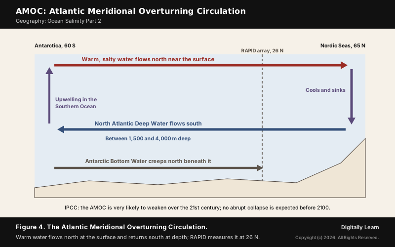
- Upper limb: Warm, more saline water flows north in the upper layers. It is salty because evaporation is high in the tropics.
- Overturning: When this water cools in the north, its density rises and it sinks into the deep.
- Lower limb: Cold, less salty deep water returns south.
- What it warms: Scandinavia, Great Britain and Ireland are warmed by the North Atlantic Current, so a weaker AMOC would lower their average air temperatures.
AMOC Slowdown and Collapse: What the IPCC Says
Warming and melting both work against the AMOC. Higher ocean heat content and more fresh water from the melting Greenland ice sheet make the northern water lighter, as does more rain over the North Atlantic, and warm, fresh water sinks less readily than cold, salty water. Direct measurement is recent: the RAPID array at 26 degrees north has recorded the circulation only since 2004.
- Recent record: A study by NOAA scientists found extensive weakening in the 2000s that has paused since the early 2010s, a tug-of-war between natural and human-caused signals.
- Longer view: Reconstructions suggest the AMOC was weaker by 2015 than before the Industrial Revolution, though how much of this is due to climate change is still debated.
- IPCC assessment: The AMOC is very likely to weaken over the 21st century under all emissions scenarios; there is medium confidence that it will not collapse abruptly before 2100.
- If it did collapse: The IPCC expects abrupt shifts in weather and the water cycle: a southward shift of the tropical rain belt, weaker African and Asian monsoons, stronger southern-hemisphere monsoons and drying in Europe.
An AMOC collapse would be one of the tipping points of the climate system, because it would not reverse easily. How salinity, El Nino and the Indian Ocean Dipole shape the monsoon is covered in Ocean Salinity Part 3.
Indian Ocean Circulation and Rising Ocean Stratification
Indian Ocean: No Deep Water, Monsoon Currents and the Throughflow
The Indian Ocean makes no deep water of its own. Asia closes it off in the north, which blocks the export of heat and prevents the ventilation of its thermocline, so its deep water arrives from the south. Antarctic Bottom Water enters through the Crozet-Kerguelen Gap, a flow of 2.5 Sv that takes 23 years to reach the gap.
- Monsoon currents: The Indian Ocean monsoon, the strongest on Earth, reverses the Somali Current and the Indian Monsoon Current with the seasons.
- Upwelling: Cold water rises near the Horn of Africa and the Arabian Peninsula.
- Indonesian Throughflow: It is the Indian Ocean’s unique equatorial connection to the Pacific, bringing warm, fresher Pacific water in.
- Two seas, two salinities: The average salinity of the Indian Ocean is 35 parts per thousand. The Bay of Bengal is less salty because of river water from the Ganga; the Arabian Sea is saltier because of high evaporation and little fresh water.
The salinity of the two Indian seas and its effect on the monsoon are covered in Ocean Salinity Part 5.
Rising Ocean Stratification: Oxygen, Nutrients and Argo Floats
Warming is making the ocean more layered. Between 1960 and 2018 upper-ocean stratification increased by 0.7 to 1.2 per cent per decade. The Southern Ocean saw the fastest rise, followed by the Pacific, Atlantic and Indian Oceans. Temperature drives most of this change, and salinity plays a role only locally.
- Less oxygen: A more stratified upper ocean mixes less, so less oxygen reaches the interior; oxygen levels have dropped in many upper-ocean regions since the mid-20th century.
- Fewer nutrients: Stronger layering limits the supply of nutrients to the sunlit surface.
- The outlook: The IPCC finds it virtually certain that upper-ocean stratification will keep increasing through the 21st century.
These changes are tracked by the Argo programme, a fleet of almost 4,000 drifting floats. Each float drifts at 1,000 m and, every 10 days, dives to 2,000 m and rises to the surface, measuring conductivity, temperature and pressure; scientists calculate salinity and density from these. In November 2012 an Indian float gathered the programme's one-millionth profile.
The human pressures on salinity, from dams to desalination, are covered in Ocean Salinity Part 7.
Previous Year UPSC-CSE Questions
Previous Year UPSC-CSE Questions By the end you will be able to draft model answers for the following UPSC questions. Each question carries a collapsible framework showing how to approach it in the exam.
- UPSC Prelims 2012 Prelims-GSConsider the following factors :
- Rotation of the Earth
- Air pressure and wind
- Density of ocean water
- Revolution of the Earth
Which of the above factors influence the ocean currents?
How to approach this Prelims question
Approach: Keep the forces that act on water; drop the one that does not.
Trap to watch: Revolution of the Earth makes seasons; it does not push ocean water.
Key facts to recall:
- Coriolis force comes from the Earth's rotation
- Density differences drive deep currents
Answer signal: 1, 2 and 3, option (b).
- UPSC Prelims 2002 Prelims-GSConsider the following statements:
- Ocean currents are the slow surface movement of water in the ocean.
- Ocean currents assist in maintaining the Earth’s heat balance.
- Ocean currents are set in motion primarily by prevailing winds.
- Ocean currents are affected by the configuration of the ocean floor.
Which of these statements are correct?
How to approach this Prelims question
Approach: Test each statement against how surface and deep currents work.
Trap to watch: Statement 4 looks odd, but ridges and straits such as the Bering Strait decide where deep water can go.
Key facts to recall:
- Oceanic circulation transports heat between latitudes
- The shallow Bering Strait stops NADW entering the Pacific
Answer signal: All four statements, option (d).
- UPSC Prelims 1997 Prelims-GSWhich one of the following factors is responsible for the change in the regular direction of the ocean currents in the Indian Ocean?
How to approach this Prelims question
Approach: Ask what is unique to the northern Indian Ocean: seasonal reversal of winds.
Trap to watch: Salinity variation does not reverse currents; the monsoon winds do.
Key facts to recall:
- The Indian Ocean monsoon is the strongest on Earth
- It reverses the Somali Current
Answer signal: Monsoon drift, option (b).
- UPSC Mains 2015 GS-IExplain the factors responsible for the origin of ocean currents. How do they influence regional climates, fishing, and navigation?
How to structure the answer in the exam
Introduction: Define ocean currents as a regular volume of water moving along a definite path, driven at the surface by wind and at depth by density.
Body (sub-themes to develop):
- Origin: solar heating (8 cm higher sea at the equator), wind, gravity, Coriolis force, density.
- Climate: cool, foggy, arid tropical west coasts; mild marine west coasts higher up; Gulf Stream warmth.
- Fishing: mixing zones of warm and cold water and upwelling coasts are the richest grounds.
- Navigation: ships use current forecasts to dock and sail safely; drift is measured in knots; search-and-rescue and oil-spill response follow the currents.
Conclusion: Conclude that currents redistribute heat and nutrients, so a change such as a weaker AMOC reaches climate, fisheries and shipping.
- UPSC Mains 2019 GS-IHow do ocean currents and water masses differ in their impacts on marine life and coastal environment? Give suitable examples?
How to structure the answer in the exam
Introduction: Currents are horizontal flows near the surface; water masses are bodies of water with their own temperature and salinity, formed where dense water sinks.
Body (sub-themes to develop):
- Currents and marine life: mixing zones and upwelling (Canary, Benguela) feed plankton and fish.
- Currents and coasts: cool, foggy, arid tropical west coasts; warm, rainy east coasts.
- Water masses and marine life: AABW carries oxygen to the abyss; upwelling deep water returns nutrients.
- Water masses and coasts: weaker sinking (AMOC) means less heat for north-west Europe.
Conclusion: Conclude that currents act on seasons and coasts, water masses on centuries and the deep ocean, and both are changing with warming.
- UPSC Mains 2022 GS-IWhat are the forces that influence ocean currents? Describe their role in fishing industry of the world.
How to structure the answer in the exam
Introduction: Currents are driven by solar heating, wind, gravity and the Coriolis force at the surface and by density at depth.
Body (sub-themes to develop):
- Forces: heating (sea 8 cm higher at the equator), wind friction, gravity, Coriolis gyres, density.
- Mixing zones: oxygen and plankton where warm and cold currents meet, the best fishing grounds.
- Upwelling: offshore winds raise cold, nutrient-rich water, as in the Canary and Benguela Currents.
- Deep circulation: nutrients return to the surface only where deep water upwells.
Conclusion: Conclude that fisheries follow the currents, so rising stratification and a weaker overturning are risks to the fishing industry.
Sources
- NCERT: Fundamentals of Physical Geography (Class XI), Water (Oceans) and Movements of Ocean Water
- NOAA National Ocean Service: What is the global ocean conveyor belt?
- NOAA National Ocean Service: Thermohaline circulation
- NOAA National Ocean Service: The global conveyor belt
- NOAA National Ocean Service: What is a thermocline?
- NOAA National Ocean Service: How currents affect our lives
- NOAA National Ocean Service: The conveyor belt and climate change
- NOAA Climate.gov: Advancing our understanding of the AMOC
- NASA Jet Propulsion Laboratory: Atlantic conveyor belt study
- IPCC AR6 Working Group I: Summary for Policymakers
- Wikipedia: Thermohaline circulation
- Wikipedia: Atlantic meridional overturning circulation
- Wikipedia: North Atlantic Deep Water
- Wikipedia: Antarctic bottom water
- Wikipedia: Halocline
- Wikipedia: Pycnocline
- Wikipedia: Ocean stratification
- Wikipedia: Argo (oceanography)
- UPSC: Civil Services Examination question papers
Editorial Disclaimer
This article draws on the NCERT geography textbooks, NOAA, NASA, the IPCC and the other sources listed on this page. Depths and temperatures of ocean layers vary with place and season, so figures differ slightly between sources.