


Overview
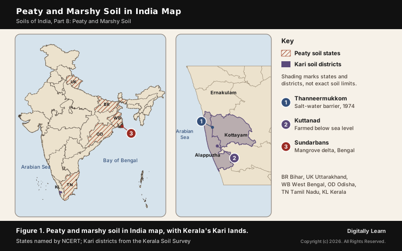
Peaty soil is a soil built from dead plant matter that could not decay because water kept the air out. It forms where heavy rain and high humidity grow dense vegetation, and its organic matter may reach 40 to 50 per cent. Marshy soil is the waterlogged soil of marshes and swamps. In Kerala the peaty, acid soil of the Kuttanad lands is called Kari.
Peaty and Marshy Soil: Meaning, Names and Key Features
What Is Peaty Soil and What Is Marshy Soil?
Peaty soil is one of the eight classes in the NCERT scheme of Indian soils: alluvial, black, red and yellow, laterite, arid, saline, peaty and forest soils. Peat itself is an accumulation of partially decayed vegetation, and a peatland is a wetland whose soil is made of layers of it.
A marsh is a wetland dominated by herbaceous plants rather than trees; the word is also used for any low-lying, seasonally waterlogged land. A swamp is dominated by trees, and a mire is a wetland that has built up deposits of acid peat. Peaty and marshy soils are the soils of these wetlands, which is why the two names travel together.
Characteristics of Peaty Soil: Organic Matter, Colour and Reaction
Organic matter is the defining feature. In peaty soils it may go up to 40 to 50 per cent, and the soils are normally heavy and black. NCERT adds that at many places they are alkaline, but the peaty Kari soils of Kerala are the opposite: extremely acid, with a pH below 4.
| Feature | Peaty soil | Kari soil of Kerala |
|---|---|---|
| Organic matter | Up to 40 to 50 per cent | Decomposed matter and wood debris in the subsoil |
| Colour and weight | Heavy and black | Sandy clay to clay, with sand pockets |
| Reaction | Alkaline at many places | Extremely acid, pH below 4 |
| Water | Waterlogged, high rainfall | Poor drainage, below mean sea level |
| Main limits | Waterlogging | Acidity, salinity, toxic elements, low fertility |
Soil scientists give peat a precise threshold. A Histosol, the international class for organic soils, has organic carbon of 12 per cent or more by weight under Soil Taxonomy, or 20 per cent or more under the World Reference Base, and a peatland is land with peat at least 30 cm deep.
How Peaty Soil Forms: Waterlogging and Slow Decay
Formation of Peaty Soil Under Heavy Rain and Waterlogging
Peaty soils form in areas of heavy rainfall and high humidity, where vegetation grows well. A large quantity of dead organic matter accumulates, and this gives the soil its rich humus and organic content.
- Supply: Dense vegetation adds leaves, roots and stems every year.
- Waterlogging: Standing water keeps oxygen out, so decomposition stays incomplete.
- Balance: A Histosol forms whenever organic matter builds up faster than it is destroyed.
- Result: Plant matter that does not fully decay in acid, oxygen-poor conditions becomes peat.
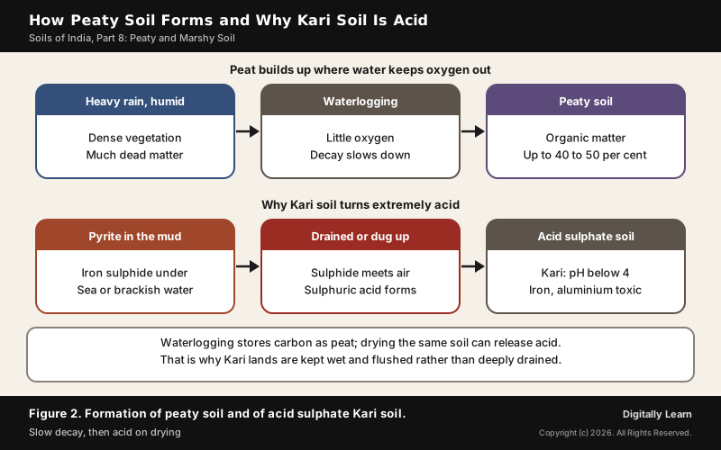
Heat on its own speeds decay. On laterite, bacteria that thrive in high temperature remove humus fast, so the soil ends up poor in organic matter. Tropical peat forms only where the forest stands on waterlogged ground, as under the rainforests of the Congo Basin and Kalimantan. What saves organic matter in a peaty soil is water, which shuts out the air that decomposers need.
Acid Sulphate Soils: Why Drained Kari Land Turns Acid
Some waterlogged coastal soils also carry iron sulphide, mostly as the mineral pyrite. It forms under waterlogged, oxygen-free conditions, when bacteria reduce the sulphate in sea or ground water; tropical mangrove swamps and estuaries hold more pyrite than temperate ones.
Pyrite is harmless while it stays wet. If the soil is drained, dug up or otherwise exposed to air, the sulphides react with oxygen to form sulphuric acid, which can in turn release iron, aluminium and other metals. Such soils are called acid sulphate soils, and in parts of Australia soils drained a century back are still releasing acid.
Kerala's Kari lands fit the pattern. The Kerala Soil Survey links their high acidity to a high content of sulphidic material, and traces the extreme acid to decomposed organic matter and wood debris in the subsoil together with sea-water intrusion. Cultivating organic layers also makes them decompose and shrink, which brings the water table up to the surface.
Where Peaty and Marshy Soil Is Found in India
Peaty Soil in India: Bihar, Uttarakhand and the Eastern Coasts
NCERT places peaty soil in India widely in the northern part of Bihar, the southern part of Uttarakhand and the coastal areas of West Bengal, Odisha and Tamil Nadu. Marshy ground also marks the Tarai, where streams re-emerge below the foothills without defined channels and create marshy and swampy conditions with luxuriant vegetation.
The Tarai is a land of tall grasslands, scrub savannah, sal forests and clay-rich swamps. The Indian Tarai stayed largely uninhabited until the end of the 19th century, because its dense marsh and malaria-filled jungle were hard and dangerous to enter.
On the east coast the largest marshy tract is the Sundarbans, the world's largest mangrove forest at 10,277 square kilometres, of which about 4,260 lie in India. The delta is a zone of transition between the fresh water of the Ganga's rivers and the salt water of the Bay of Bengal. India's mangroves are most highly developed in the Andaman and Nicobar Islands and the Sundarbans. The fertile soils of the delta have been used intensively for centuries, and much of the delta ecoregion has been converted to farmland.
Kari Soil of Kerala: Alappuzha, Kottayam and Kuttanad
Kari soils occur in the Alappuzha and Kottayam districts, in marshy areas lying below mean sea level. The Kerala Soil Survey groups the state's soils into coastal alluvium, mixed alluvium, acid saline, kari, laterite, red, hill, black cotton and forest soils.
- Drainage: Poor, with the land at or below sea level.
- Acidity: Extreme, pH below 4.
- Salts: Toxic concentrations of soluble salts from sea-water intrusion.
- Organic matter: Decomposed matter and wood debris in the lower layers.
- Texture: Sandy clay to clay, with silty clay loam and clay loam in between and pockets of sand.
Kerala has no large continuous peats. Its organic soils, the Histosols, are found in the Kuttanad Kari lands, in low ground under permanent saturation, and carry the numerous nutrient problems that come with high acidity and sulphidic material.
Kari sits within a wider family of low-lying Kerala soils. Mixed alluvium occurs next to the coastal alluvium, around Kuttanad and in the Kole lands of Thrissur district, mostly on plains at or below sea level, and the coastal belt itself generally lies below 5 metres above mean sea level.
Peaty Soil and Saline Soil: How Coastal Wetland Soils Differ
Peaty and saline soils often lie side by side, and both appear in the Sundarbans. Saline soils, also called Usara soils, carry more sodium, potassium and magnesium; they form in dry, badly drained land and also in waterlogged and swampy areas, and sea-water intrusion in the deltas spreads them.
| Point | Peaty soil | Saline soil |
|---|---|---|
| What builds up | Dead organic matter, up to 40 to 50 per cent | Salts of sodium, potassium, magnesium |
| Why | Heavy rain, vegetation, waterlogging | Dry climate, poor drainage, sea-water intrusion |
| Where (NCERT) | North Bihar, south Uttarakhand, coastal WB, Odisha, TN | Western Gujarat, east coast deltas, Sundarbans |
| Fertility | Rich in humus but waterlogged | Infertile; lacks nitrogen and calcium |
| Remedy | Controlled water, flushing (Kari) | Gypsum in Punjab and Haryana |
Kerala's Kari combines both problems: it is organic like a peaty soil and salt-affected like a saline one, with extreme acid on top. That is why its management leans on fresh water, to flush out salts and acid, rather than on drainage alone. Saline and alkaline soils are covered in full in Part 7.
Marshy Land in India: Wetland Extent and Types
Marshy soils belong to wetlands, and India has many. The National Wetland Decadal Change Atlas of 2017, prepared by the Space Applications Centre of ISRO, mapped 2,31,195 wetlands covering 15.98 million hectares including rivers but excluding paddy fields, about 4.86 per cent of the country's area.
The legal definition is broad. Under the Wetlands (Conservation and Management) Rules, 2017, a wetland is an area of marsh, fen, peat land or water, natural or artificial, permanent or temporary, with water static or flowing, fresh, brackish or salt, including marine water no deeper than six metres at low tide.
- Freshwater marsh: The Tarai belt below the Himalayan foothills.
- Mangrove swamp: The Sundarbans delta and the Andaman and Nicobar coasts.
- Backwater and lake: The Vembanad wetland system of Kerala, over 2,033 square kilometres.
- Salt marsh: The Rann of Kutch, salt marshes over some 26,000 square kilometres, where the monsoon deposits salt as a crust.
Kuttanad: Farming Peaty Kari Soil Below Sea Level
Kuttanad Farming System: Rice Below Sea Level and GIAHS Status
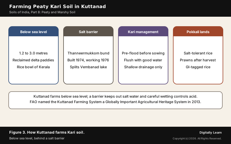
A river delta region of Kerala, Kuttanad spreads over the Alappuzha, Kottayam and Pathanamthitta districts. It has the lowest altitude in India and is one of the few places in the world where farming is carried on 1.2 to 3.0 metres below sea level, in rice paddies laid out largely on land reclaimed from the delta.
It lies on the southern side of Vembanad, the longest lake in India. The Vembanad wetland system covers over 2,033 square kilometres, of which 398.12 square kilometres lie below mean sea level, and large farming areas near the lake were reclaimed from it. The region is the major rice producer of the state, known as the Rice Bowl of Kerala. Reclamation went on in phases; one phase began in 1888, when stretches of the lake near the mouth of the Chennamkari river were reclaimed.
Thanneermukkom Bund: Salt-Water Barrier and Its Ecological Costs
Farming below sea level needs protection from the tide. The Thanneermukkom Bund was built across Vembanad Lake in 1974, as part of the Kuttanad Development Scheme, to stop tidal action and salt-water intrusion into the low-lying fields; it has worked since 1976 and is the largest mud regulator in India.
| Effect | What changed |
|---|---|
| Lake split in two | Brackish water on one side, fresh water on the other |
| Coastal reservoir | The only coastal reservoir in India |
| Farming | Helped farmers who work below sea level |
| Weeds | Water hyacinth spread in the fresh water |
| Fisheries | Catch fell; fish need some salt water to breed |
The barrier shows the trade-off in managing marshy land. By holding the sea back it made the upstream lake fresh, which helped the rice but hurt the fish that need some salt water to breed; by 2005 the region's fishermen were opposed to the bund.
Managing Kari Soil: Pre-Flooding, Flushing and Pokkali Farming
Because drying releases acid, Kari soils are managed by keeping them wet and clean rather than by deep drainage. The Kerala Soil Survey lists the measures:
- Leave the subsoil alone: Avoid disturbing it, so less acid is generated.
- Pre-flooding: Flood the field before planting so that acidity is reduced.
- Double cropping: Grow rice twice, or rice and shrimps as on Pokkali lands, to shorten the time the soil dries.
- Flushing: Flush the surface often with good quality water.
- Shallow drainage: Broad, shallow ditches between raised beds, so fresh water leaches acid and salts without deep drainage.
Pokkali farming shows the rice and shrimp rotation at work. A salt-tolerant rice is grown organically on about 5,000 hectares of waterlogged coastal land in Alappuzha, Kottayam, Thrissur and Ernakulam: rice from June to early November when salinity is low, then prawns from mid-November to mid-April. The prawns feed on the crop residue and the rice needs no other fertiliser; the brand has a GI tag.
Peatlands, Carbon and Methane: Why Peaty Soils Matter
Peatlands as Carbon Stores: Congo Basin and Global Extent
Peatlands cover around 3 per cent of the globe's surface, yet they are the largest natural carbon store on land. Peat stores up to 550 gigatonnes of carbon, about 42 per cent of all soil carbon, more than all other vegetation types including the world's forests.
- Northern peatlands: About 64 per cent of the world’s mires lie in the temperate, boreal and subarctic north.
- Tropical peatlands: Found under tropical rainforest in Kalimantan, the Congo Basin and the Amazon basin.
- Largest tropical peatland: The Central Congo Basin, about 145,500 square kilometres.
- Indonesia: About 24 million hectares, on Sumatra, Kalimantan and Papua.
The carbon is released when peat dries. Draining and harvesting tropical peat forests emits large amounts of carbon dioxide, fires on drained peat release more, and a severe fire can release up to 4,000 tonnes of carbon dioxide per hectare.
Peat is also a record and a resource. Because it builds up over thousands of years, a peat deposit preserves plant remains such as pollen that record past vegetation and climate. Dried peat can be burnt as fuel, and peat formation is often the first step towards coal, especially low-grade coal such as lignite.
Methane From Wetlands and Rice Paddies
Waterlogged soils do not only store carbon; they also release it as methane. Methane is made by microbes called methanogens, all of them archaea, and many live alongside anaerobic bacteria, so methane comes from the oxygen-free mud of wetlands and flooded fields.
Paddy fields are a major source. Rice paddies account for about 10 per cent of global methane emissions, roughly equal to aviation, and studies show that draining paddies to let the soil breathe interrupts methane production while also raising yields. Wetlands, rice fields, coal mining and domestic animals are all sources of the gas.
Organic matter also changes how a soil holds water. Humus absorbs water and swells and shrinks between wet and dry states more than clay does, increasing porosity, and soil organic matter improves water retention. A soil rich in organic matter therefore holds more water, not less.
Wetland Conservation in India: Ramsar Sites and Rules
Ramsar Convention and the Concept of Wise Use
The Ramsar Convention, signed in 1971 in the Iranian city of Ramsar, provides the framework for the conservation and wise use of all wetlands through local and national action and international cooperation. Wise use means using a wetland while maintaining its ecological character, not fencing it off.
- Count: India’s Ramsar sites reached 101 on 3 August 2026, up from 26 in 2014.
- First sites: Chilika Lake in Odisha and Keoladeo National Park in Rajasthan.
- Largest: The Sunderban Wetland in West Bengal, about 423,000 hectares.
- Kerala: The Vembanad-Kol Wetland, listed in 2002, the largest of the state’s three Ramsar sites.
- Montreux Record: Keoladeo National Park and Loktak Lake, sites where ecological change has occurred or is likely.
India's rules follow the same idea. The Wetlands (Conservation and Management) Rules, 2017, made under the Environment (Protection) Act, 1986, aim to conserve, manage and maintain the ecological character of wetlands without restricting their wise use.
National Wetland Conservation Programme and NPCA
Central help for wetlands long came through the National Wetlands Conservation Programme (NWCP), which, with the National Lake Conservation Plan, gave the States financial help for identified wetlands and lakes until 2012-13. The Vembanad wetland was among those identified under the NWCP.
In February 2013 the two were merged into the National Plan for Conservation of Aquatic Ecosystems (NPCA), a centrally sponsored scheme run on cost sharing between the Centre and the States. Later steps include:
- Wetlands of India portal: Launched on 2 October 2021 with data and dashboards for each State.
- Wetlands Rejuvenation Programme: Started in 2020 for over 500 wetlands.
- Centre for Wetland Conservation and Management: Set up on World Wetlands Day 2021.
- Amrit Dharohar: Announced in the Union Budget 2023-24 for optimal use of wetlands, biodiversity, carbon stock and eco-tourism.
Previous Year UPSC-CSE Questions
Previous Year UPSC-CSE Questions By the end you will be able to draft model answers for the following UPSC questions. Each question carries a collapsible framework showing how to approach it in the exam.
- UPSC Mains 2018 GS-IIIWhat is wetland? Explain the Ramsar concept of ‘wise use’ in the context of wetland conservation. Cite two examples of Ramsar sites from India.
How to structure the answer in the exam
Introduction: A wetland is an area of marsh, fen, peat land or water, fresh, brackish or salt, including sea water up to six metres deep at low tide.
Body (sub-themes to develop):
- Wise use: conservation with sustainable use, maintaining ecological character.
- Indian framework: Wetlands (Conservation and Management) Rules, 2017 under the EP Act, 1986.
- Examples: Vembanad-Kol Wetland (Kerala, 2002), Sunderban Wetland (West Bengal).
Conclusion: Conclude that wise use lets communities such as Kuttanad's farmers use a wetland without destroying it.
- UPSC Mains 2023 GS-IIIComment on the National Wetland Conservation Programme initiated by the Government of India and name a few India’s wetlands of international importance included in Ramsar sites.
How to structure the answer in the exam
Introduction: The National Wetlands Conservation Programme funded States to conserve identified wetlands until 2012-13.
Body (sub-themes to develop):
- NWCP and NLCP merged into the NPCA in 2013, a centrally sponsored scheme with cost sharing.
- Later tools: Wetlands Rules 2017, Wetlands of India portal 2021, rejuvenation of 500 wetlands, Amrit Dharohar.
- Scale: 2,31,195 wetlands mapped, 4.86 per cent of India's area.
- Ramsar sites: 101 by August 2026; Chilika, Keoladeo, Vembanad-Kol, Sunderban Wetland.
Conclusion: Conclude that India's Ramsar network has grown fast, and the task now is keeping listed wetlands' ecological character.
- UPSC Prelims 2024 Prelims-GSOne of the following regions has the world's largest tropical peatland, which holds about three years worth of global carbon emissions from fossil fuels; and the possible destruction of which can exert detrimental effect on the global climate. Which one of the following denotes that region?
How to approach this Prelims question
Approach: Recall where the largest tropical peatland lies.
Trap to watch: The Amazon basin has peatlands too, but the largest tropical one is in the Congo Basin.
Key facts to recall:
- Central Congo Basin, about 145,500 square kilometres
- Peat holds about 42 per cent of soil carbon
Answer signal: Congo Basin, option (b).
- UPSC Prelims 2023 Prelims-GSConsider the following statements : Statement-I : The soil in tropical rain forests is rich in nutrients. Statement-II : The high temperature and moisture of tropical rain forests cause dead organic matter in the soil to decompose quickly. Which one of the following is correct in respect of the above statements?
How to approach this Prelims question
Approach: Judge each statement, then the link.
Trap to watch: Fast decay makes rainforest soil poor, not rich; waterlogging, not heat, preserves organic matter.
Key facts to recall:
- Bacteria remove humus fast in high temperature
- Peat forms only where water shuts out air
Answer signal: Statement I incorrect, Statement II correct: option (d).
- UPSC Prelims 2008 Prelims-GSConsider the following:
- Rice fields
- Coal mining
- Domestic animals
- Wetlands
Which of the above are sources of methane, a major greenhouse gas?
How to approach this Prelims question
Approach: Check each against the sources of methane.
Trap to watch: Wetlands are a natural source; do not drop them because they are not man-made.
Key facts to recall:
- Methanogens are archaea in oxygen-free mud
- Paddies give about 10 per cent of global methane
Answer signal: All four, option (d).
- UPSC Prelims 2018 Prelims-GSWith reference to agricultural soils, consider the following statements :
- A high content of organic matter in soil drastically reduces its water holding capacity.
- Soil does not play any role in the sulphur cycle.
- Irrigation over a period of time can contribute to the salinization of some agricultural lands.
Which of the statements given above is/are correct ?
How to approach this Prelims question
Approach: Test each statement against how organic matter behaves.
Trap to watch: Statement 1 reverses the effect of organic matter on water.
Key facts to recall:
- Humus absorbs water and increases porosity
- Irrigation can salinise land (Part 7)
Answer signal: 3 only, option (b).
Sources and Further Reading
- NCERT: India Physical Environment (Class XI), Soils and Physiography
- Kerala Soil Survey: Kari Soils
- Kerala Soil Survey: Soils of Kerala
- Kerala Soil Survey: Histosols
- PIB: Glaw Lake becomes India's 101st Ramsar Site (3 August 2026)
- PIB: National Plan for Conservation of Aquatic Ecosystems (27 March 2023)
- PIB: Wetlands in India (8 August 2022)
- PIB: India's Wetland Wonder (14 August 2024)
- PIB: World Wetlands Day backgrounder (February 2023)
- Wikipedia: Peat
- Wikipedia: Peatland
- Wikipedia: Histosol
- Wikipedia: Acid sulfate soil
- Wikipedia: Kuttanad
- Wikipedia: Thanneermukkom Bund
- Wikipedia: Pokkali
- Wikipedia: Sundarbans
- Wikipedia: Paddy field
- Wikipedia: List of Ramsar sites in India
- UPSC: Previous year question papers
Editorial Disclaimer
This article is compiled from the reference materials listed in the Sources section. It is an explainer for UPSC preparation and is not a substitute for primary documents (NCERTs, GoI ministry releases, IMD bulletins, RBI / CEA / MoEFCC publications, and Standing-Committee reports).