


Overview
Theories of monsoon, the burst and the break
When the monsoon arrives and leaves, why it bursts and breaks, and how the theories explain it.
The onset of monsoon in India is the arrival of the south-west monsoon over Kerala, normally around 1 June, after which it covers India by about 8 July; the withdrawal of monsoon begins in north-west India around 17 September and is complete by about 15 October. The thermal, dynamic and jet stream theories each explain part of why the monsoon comes and goes.
Theories of Monsoon: Thermal, Dynamic and Jet Stream
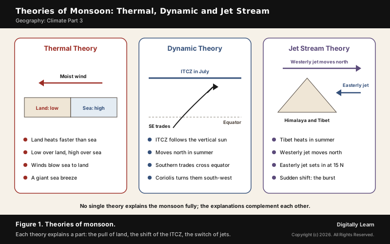
Thermal Theory of Monsoon: Differential Heating of Land and Sea
No single theory has explained the monsoon fully, and the thermal theory came first. It portrays the monsoon as a giant sea breeze: in April and May, with the sun overhead near the Tropic of Cancer, the large landmass north of the Indian Ocean heats intensely and an intense low pressure forms over the north-west of the subcontinent, while the ocean, heating slowly, keeps higher pressure.
- Summer: Moist winds flow from the high over the sea to the low over the land, rise over the relief, cool and give orographic rain: the south-west monsoon.
- Winter: The land turns colder than the sea, the pressure gradient reverses, and dry winds blow out from the land as the north-east monsoon.
- The criticism: Many meteorologists hold that the monsoon is not local but a weather phenomenon along the whole tropical zone; differential heating is one factor, not the only one.
Towards the end of the nineteenth century this was the accepted explanation. It accounts well for the reversal of winds between summer and winter, and the dynamic and jet stream theories add the parts it leaves out.
Dynamic Theory of Monsoon: The Shifting ITCZ
The dynamic theory explains the monsoon as the seasonal shift of the global belts of pressure and winds. The Inter Tropical Convergence Zone (ITCZ), the low-pressure belt where the trade winds meet, follows the vertical sun north in the northern summer.
- The pull: With the ITCZ north of the equator, the south-east trades of the Southern Hemisphere must cross the equator to reach it.
- The turn: Crossing between 40 and 60 degrees E, they are deflected by the Coriolis force and blow from the south-west: the south-west monsoon is a continuation of the south-east trades.
- July position: By mid-July the ITCZ lies roughly parallel to the Himalayas between 20 and 25 degrees N.
- Winter: The ITCZ moves south, the winds reverse, and the north-east monsoon blows.
Coupled with the thermal idea, the dynamic theory explains why monsoon rain varies in intensity along coasts backed by barriers such as the Western Ghats. The German climatologist Hermann Flohn helped develop the theory of atmospheric circulation from 1950 and wrote on the meteorology of the Tibetan highlands. The ITCZ and its monsoon trough are explained in detail in Indian Monsoon Part 1.
Jet Stream Theory of Indian Monsoon: Tibet and the Easterly Jet
The jet stream theory explains the timing of the monsoon through the jets of the upper air. In winter a subtropical westerly jet blows south of the Himalayas; in summer it is replaced over India by the tropical easterly jet, and the intense heating of the Tibetan Plateau is believed to be the critical factor.
- The switch: The easterly jet sets in along 15 degrees N only after the westerly jet has withdrawn from the north Indian plain.
- Timing: A timely northward shift of the westerly jet brings a timely monsoon; a delay delays it, and an early shift brings an early monsoon.
- Strength: A strong easterly jet over central India goes with a strong south-west monsoon, and a weak jet with a weak one.
Monsoon Circulation: Somali Jet, Mascarene High and Monsoon Trough
Each summer a chain of connected systems, from the south Indian Ocean to Tibet, drives the monsoon. The theories supply the reasons; these are the working parts.
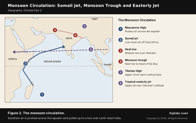
- Mascarene High: A high near the Mascarene Islands drives the cross-equatorial flow through the south Arabian Sea; its surges bring heavy rain to the west coast.
- Somali jet: A low-level jet, 1 to 1.5 km up, from near Mauritius and Madagascar along the Kenya and Somali coasts; it reaches the west coast of India in June and peaks in July.
- Heat low: A shallow low, up to about 1.5 km, over north-west India, Pakistan and West Asia; an intense heat low draws moist air along the monsoon trough, and a weak one, as in the drought year 1987, brings scanty rain.
- Monsoon trough: An elongated low from the heat low over Pakistan to the head of the Bay of Bengal, along which the rain-bearing depressions travel.
- Tibetan High: A warm anticyclone over the Tibetan Plateau in the middle and upper troposphere, marked at 300 hPa.
- Tropical easterly jet: South of the subtropical ridge over Asia, the easterly flow concentrates into a jet at about 150 hPa near the latitude of Chennai, running from Vietnam to the west coast of Africa.
Onset of Monsoon: Arrival over Kerala and Advance across India
What Is the Onset of Monsoon? How the IMD Declares It
The onset of monsoon means the arrival of the south-west monsoon, and it is declared first over Kerala. The India Meteorological Department uses criteria adopted in 2016, based on rain at 14 stations in Kerala and nearby, the wind field and outgoing longwave radiation over the south-east Arabian Sea.
- Rainfall: After 10 May, if 60 per cent of the 14 stations report 2.5 mm or more of rain on two consecutive days, onset is declared on the second day, if the other criteria agree.
- Wind: Westerlies must extend up to 600 hPa between the equator and 10 degrees N, with zonal winds of 15 to 20 knots at 925 hPa off Kerala.
- Cloud: Satellite-measured outgoing longwave radiation must fall below 200 watts per square metre over the south-east Arabian Sea, a sign of deep cloud.
- Advance: Further advance is declared as rain spreads, keeping the northern limit of monsoon continuous.
Satellites supply much of this evidence. Oceansat-2, launched by ISRO on 23 September 2009, carried an Ocean Colour Monitor, a Ku-band scatterometer that measured ocean surface winds, and a radio occultation sounder for the atmosphere; its data served weather forecasting, sea-state forecasting, fishing zones and coastal zone studies.
Normal Dates of Onset: Kerala on 1 June, All India by 8 July
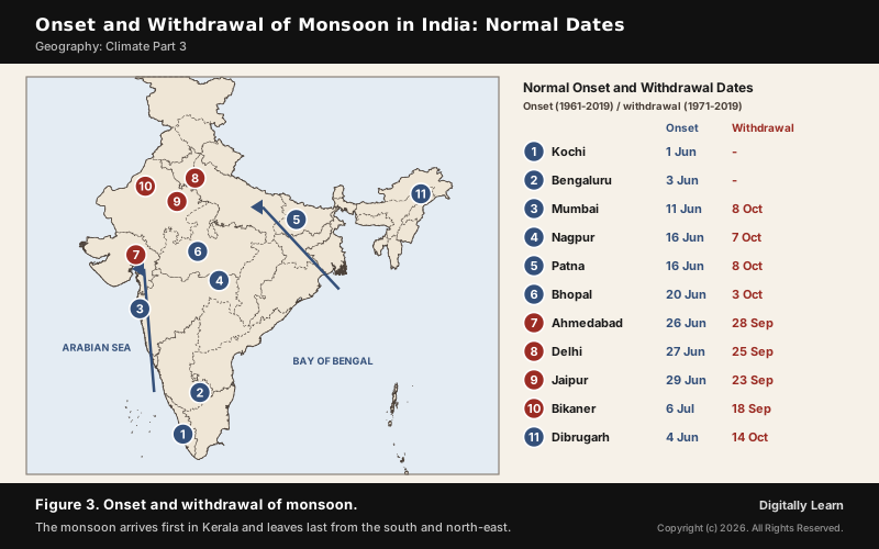
Under the IMD's new normal dates, the monsoon sets in over Kerala around 1 June and covers the whole country by 8 July, a week earlier than the old normal of 15 July. It reaches Mumbai around 11 June and moves swiftly north.
- Two branches: The Arabian Sea branch brings rain to the west coast, much of it orographic along the Western Ghats; the Bay of Bengal branch brings rain to the plains of north India.
- Arrival of monsoon in India’s cities: Bengaluru 3 June, Mumbai 11 June, Patna and Nagpur 16 June, Bhopal 20 June, Delhi 27 June, Jaipur 29 June and Bikaner 6 July.
- Early and late years: In 2025 the monsoon reached Kerala on 24 May, 8 days early, and covered the country by 27 June; in the El Nino year of 1990-91 onset was delayed by five to twelve days over most of the country.
What Is the Burst of Monsoon? Why the Rains Arrive Suddenly
The burst of monsoon is the sudden change from hot, dry weather to wet, humid weather, with an abrupt rise in daily rainfall, often with violent thunder and lightning. Two theories explain why it is sudden rather than gradual.
- Jet stream explanation: As Tibet heats, the low over it pulls the westerly jet north, but the lofty Himalayas hold it back until enough force builds; the shift is then abrupt, and the rains burst onto the plains. The easterly jet that follows is held responsible for the burst.
- Dynamic explanation: The Himalayas at first confine the low-pressure zone; only when the Tibetan Plateau heats much more than the Himalayas does the ITCZ jump swiftly north.
- North-east monsoon: A second, minor burst of rain falls on the eastern Peninsula in winter.
Break in the Monsoon and Monsoon Variability
Break in the Monsoon: Active and Dry Spells
A break in the monsoon is a spell of one or more weeks without rain after a few days of rain, in the middle of the rainy season. Such dry spells are common, and they happen for different reasons in different regions.
- North India: Rain fails when rain-bearing storms along the monsoon trough over the region are not frequent.
- West coast: Dry spells come on days when the winds blow parallel to the coast instead of onto it.
- The trough moves north: When the monsoon trough migrates to the Himalayan foothills, most of India has a break while the foothills get heavy rain and the Brahmaputra may flood; a southward trough brings an active monsoon.
- Upper air: In break conditions the tropical easterly jet moves north up to 20 degrees N.
Breaks come and go in a rhythm. The Madden-Julian Oscillation, an eastward-moving pulse of clouds and rain with a period of 30 to 60 days, is the leading source of this intra-seasonal variability, and capturing it is crucial to forecasting the active and break cycle.
El Nino, La Nina and the Indian Ocean Dipole
Year-to-year swings in the monsoon are linked to the oceans. El Nino is the appearance of warm water off the coast of Peru, once every three to seven years, which distorts the equatorial atmospheric circulation; India uses it for long-range monsoon forecasts.
- Southern Oscillation: Sir Gilbert Walker, director general of observatories in India, found a seesaw of pressure between Tahiti and Darwin, and linked low rainfall in India to high pressure over Darwin.
- ENSO: The monsoon tends to be weak, with droughts, in El Nino years and strong in La Nina years.
- Indian Ocean Dipole: Discovered in 1999, a seesaw of the ocean and atmosphere in the equatorial Indian Ocean; a positive IOD often cancels the effect of ENSO and brings more rain, as in 1983, 1994 and 1997, so the strong El Nino of 1997 caused no drought.
How the Pacific and the Indian Ocean together shape India's rains is explained in ENSO and India, and forecasts are given as a share of the long period average, 87 cm for the season: 90 per cent was forecast for 2026.
Withdrawal of Monsoon: Retreat from North-West India
Withdrawal of Monsoon: IMD Criteria and Normal Dates
The withdrawal of monsoon starts in the far north-west and moves south and east. Under the new normal dates it begins in north-west India around 17 September, more than two weeks later than the old date of 1 September, and the monsoon leaves most of the country by 15 October.
- No rain for five days: Rainfall must stop over the area for five continuous days, considered only after 1 September.
- An anticyclone: An anticyclone must set up in the lower troposphere, at 850 hPa and below.
- Drier air: Moisture must fall considerably, as seen in satellite water-vapour images.
These criteria for the withdrawal of the south-west monsoon were adopted in 2006. Further withdrawal is declared as dry weather spreads, and the monsoon leaves the southern Peninsula, and so the whole country, around 15 October, when the south-westerly winds give way. The October heat and the north-east monsoon rains that follow are covered in seasons of India and Cyclones Part 8.
Duration of Monsoon in India: Longest in the South, Shortest in the North-West
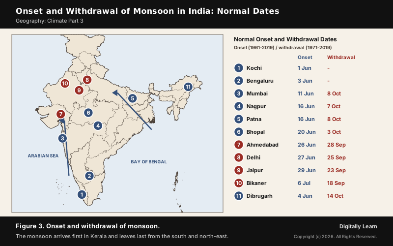
Because the monsoon arrives from the south-west and retreats from the north-west, its duration shrinks towards the north-west. The normal dates show the pattern clearly.
| City | Onset to withdrawal |
|---|---|
| Mumbai | 11 June to 8 October, about four months |
| Patna | 16 June to 8 October |
| Bhopal | 20 June to 3 October |
| Delhi | 27 June to 25 September, about three months |
| Dibrugarh | 4 June to 14 October, over four months |
| Ahmedabad | 26 June to 28 September |
| Jaipur | 29 June to 23 September |
| Bikaner | 6 July to 18 September, about ten weeks |
The pattern has two causes. The monsoon reaches Kerala and the north-east early and leaves the north-west first, and it lingers longest in the south Peninsula, which it leaves only after most of the country is dry. Western Rajasthan is at the far end of both journeys, so its season is the shortest.
Previous Year UPSC-CSE Questions
Previous Year UPSC-CSE Questions By the end you will be able to draft model answers for the following UPSC questions. Each question carries a collapsible framework showing how to approach it in the exam.
- UPSC Prelims 2010 Prelims-GSConsider the following statements: The satellite Oceansat-2 launched by India helps in
- Estimating the water vapour content in the atmosphere.
- Predicting the onset of monsoons.
- Monitoring the pollution of coastal waters.
Which of the statements given above is/are correct?
How to approach this Prelims question
Approach: Match each statement to one of Oceansat-2's three instruments.
Trap to watch: An ocean satellite also sounds the atmosphere; the radio occultation sounder served weather forecasting.
Key facts to recall:
- Scatterometer measured ocean surface winds
- Onset is declared from rain, wind and OLR
Answer signal: 1, 2 and 3, option (d).
Sources
- NCERT: India Physical Environment (Class XI), Climate
- IMD: Frequently Asked Questions on Monsoon
- IMD: New Normal Dates of Onset and Withdrawal of the Southwest Monsoon (2020)
- IMD: Monsoon 2025, A Report
- PIB (MoES): Updated Long Range Forecast for the 2026 Southwest Monsoon
- ISRO: Oceansat-2
- Wikipedia: Monsoon of South Asia
- Wikipedia: Monsoon
- Wikipedia: Tropical easterly jet
- Wikipedia: Somali Jet
- Wikipedia: Intertropical Convergence Zone
- Wikipedia: Oceansat-2
- Wikipedia: Madden-Julian oscillation
- Wikipedia: Hermann Flohn
- UPSC: Civil Services Examination question papers
Disclaimer
This article draws on the NCERT geography textbooks, the India Meteorological Department, ISRO, the Press Information Bureau and the other sources listed on this page. Onset and withdrawal dates are long-term normals; any single year may be earlier or later.