


Overview
The effect of El Nino in India is felt mainly through the south-west monsoon: when the central and eastern Pacific warms, the rising air and rain shift east, and India usually gets a weaker monsoon, with a higher risk of drought, lower farm output and higher food prices. La Nina, the cold phase, usually brings normal to above-normal rain. The link is strong but not fixed, because the Indian Ocean Dipole and other drivers can offset it.
El Nino, La Nina and ENSO: What They Are and How They Reach India
What Is El Nino Effect in India? ENSO and Its Phases
El Nino and La Nina are the warm and cool phases of ENSO, the El Nino Southern Oscillation, a natural climate pattern of the tropical Pacific. El Nino is a warm current that appears off the coast of Peru roughly once every three to seven years and raises the sea temperature there by 10 degrees C; its name means the Christ child because it appears around Christmas. La Nina is the opposite, cold phase.
- How it is declared: When the central Pacific is more than 0.5 degrees C warmer (or cooler) than normal over a three-month average, an El Nino (or La Nina) is in progress; within 0.5 degrees C, conditions are neutral. Since February 2026, NOAA measures this against the global tropics with a Relative Oceanic Nino Index.
- How long it lasts: An El Nino typically lasts nine to 12 months; La Nina events may repeat and last longer.
- The atmosphere’s half: The Southern Oscillation is the see-saw of air pressure between Tahiti and Darwin; El Nino episodes have a negative Southern Oscillation Index.
- Recent El Nino years: Since 2000, El Nino events have occurred in 2002-03, 2004-05, 2006-07, 2009-10, 2014-16, 2018-19, 2023-24 and 2026.
The effect of El Nino in India therefore arrives from thousands of kilometres away. The mechanism of the Pacific itself, with the thermocline, upwelling and the Bjerknes feedback, is explained in the article on the ENSO mechanism; this page follows what reaches India.
How El Nino Affects the Indian Monsoon: The Walker Circulation
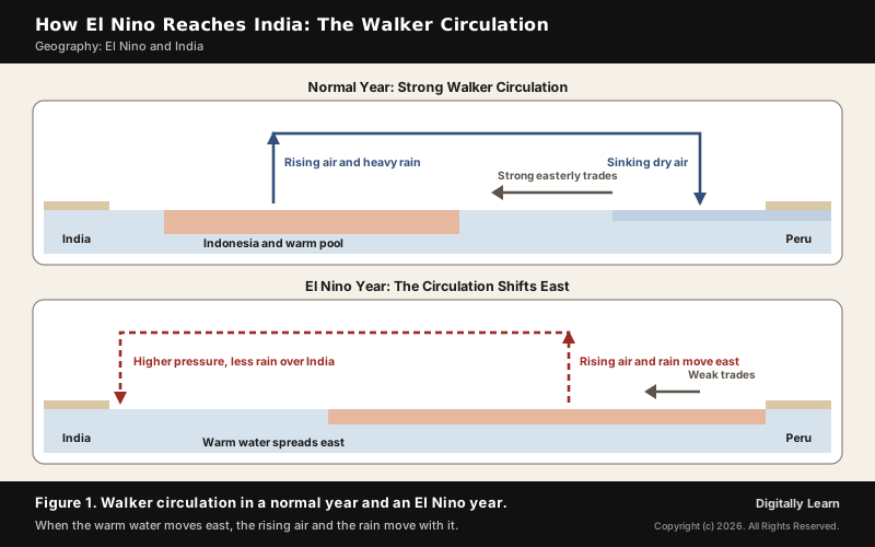
The effect of El Nino on Indian monsoon rainfall travels through the Walker circulation, an east-west loop of air along the equator. In a normal year strong easterly trade winds pile warm water in the western Pacific, where sea level near Indonesia stands about 0.5 m higher than near Peru. Air rises over this warm pool and brings heavy rain, and sinks over the cold eastern Pacific.
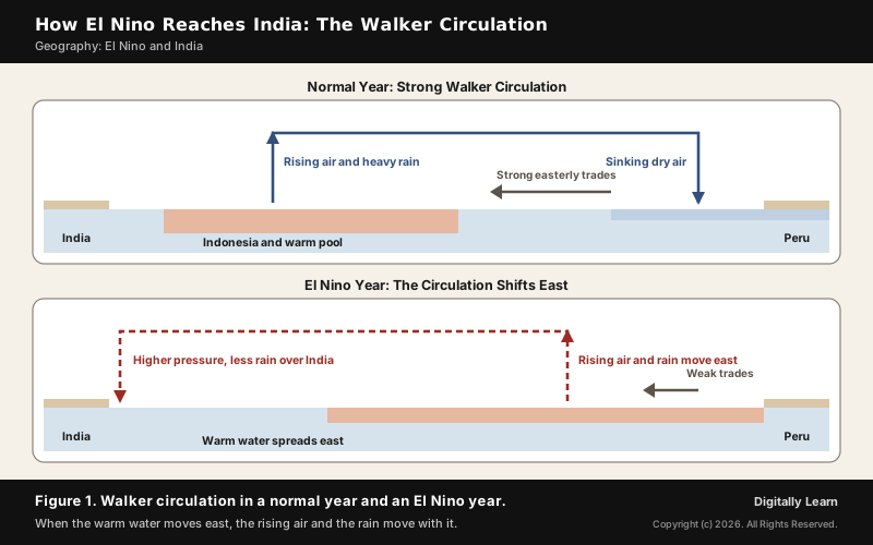
During El Nino the trade winds weaken, warm surface water surges east and upwelling of cold water off South America falls. The Walker circulation weakens and its rising branch, with the rain, moves to the central and eastern Pacific. Air pressure rises above normal over Indonesia, Australia and across the Indian Ocean, and India's monsoon usually weakens. El Nino also distorts the equatorial circulation, makes evaporation irregular and reduces the plankton and fish off Peru.
El Nino Impact on Indian Monsoon Rainfall and La Nina Effect in India
El Nino Impact on Indian Monsoon: How Often and How Much
The impact of El Nino on Indian monsoon rainfall is usually negative: during an El Nino the summer monsoon is generally weaker than normal, and the stronger the event, the larger the impact. But the link is not one-to-one. Since 1950 there have been 16 El Nino years, and in 7 of them monsoon rainfall was below normal. The link is strongest in the second half of the season, especially in September.
- Delayed onset: In 1990-91 a strong El Nino delayed the onset of the south-west monsoon over most of the country by five to twelve days.
- Drought risk: Around 43 per cent of El Nino events have been followed by drought in India, and there is a clear association between ENSO events and weak monsoons.
- Severe years: The acute drought of 2002 and the 2009 drought, the worst since 1972, both came in El Nino years.
La Nina Effect in India: More Rain and Colder Winters
La Nina brings cooler than usual sea temperatures to the central and eastern Pacific, and for India it usually means a normal to above-normal monsoon. Most parts of the country receive above-normal rain in La Nina years, except extreme north India and some areas of north-east India, where below-normal rain is likely. Winters in La Nina years are generally colder than normal.
Is La Nina good for India? For farming, generally yes: above-average monsoon rain in La Nina years is beneficial for crop production. But more rain also brings the risk of floods, and a La Nina can be overridden, as in 2025, when neutral ENSO conditions prevailed and no La Nina impact on the monsoon was expected.
| Point | El Nino | La Nina |
|---|---|---|
| Pacific sea temperature | Warmer than normal | Cooler than normal |
| Trade winds | Weaker | Stronger |
| Indian monsoon | Usually weaker; drought risk | Usually normal to above normal |
| Southern Oscillation Index | Negative | Positive |
Regional Pattern of El Nino Effect across India
El Nino does not dry the whole country equally. In El Nino years rainfall falls across most of India, with one exception: north-east India, where above-average rain is observed. The El Nino year of 2023 shows the pattern and its limits: season rainfall was 101 per cent of normal in north-west India, 100 per cent in central India, 92 per cent in the south Peninsula and 82 per cent in the north-east.
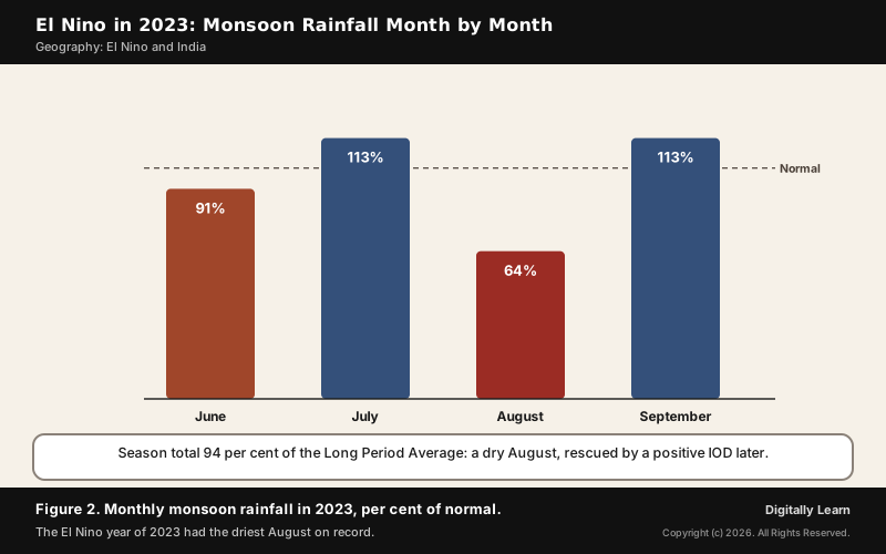
The months matter as much as the regions. In 2023 June brought 91 per cent of normal rain, July 113, August 64 and September 113; August 2023 was the driest since records began in 1901. The monsoon core zone, where most rain-fed farming lies, still received 101 per cent, so the season ended at 94 per cent of the Long Period Average.
Indian Ocean Dipole, MJO and ENSO Modoki: Drivers That Change the El Nino Effect
Indian Ocean Dipole: How a Positive IOD Offsets El Nino
The Indian Ocean Dipole (IOD) is the Indian Ocean's own see-saw of sea temperature: in the positive phase the western Indian Ocean is warmer than the eastern, and in the negative phase it is colder. It was identified in 1999, builds from April to May and peaks in October. A positive IOD tends to bring above-average rain to India, and a negative IOD below-average rain, particularly over central India and the Western Ghats.
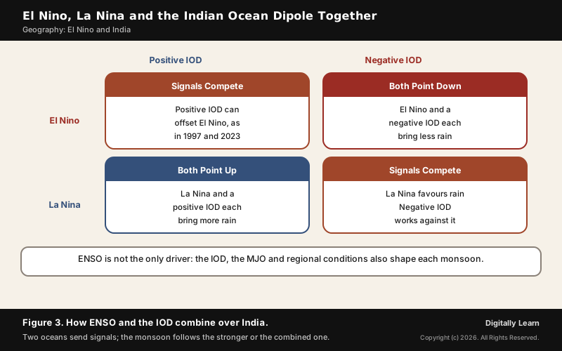
The two oceans can pull against each other. The strong El Nino of 1997 did not cause a drought in India, because a positive IOD offset it, and positive IOD years such as 1983, 1994 and 1997 brought increased rain. In 2023 the pattern repeated: rainfall fell below average in the El Nino year, but the IOD in the latter part of the season offset the deficiency and kept the season within the normal range.
MJO, ENSO Modoki and the Changing ENSO-Monsoon Link
Within a season, the Madden-Julian Oscillation decides the wet and dry spells, and El Nino can interfere with it. In 2023 the MJO stayed locked over the western hemisphere and Africa in June and August, and the El Nino over the Pacific was one reason it could not travel on; August, with the MJO away, became the record dry month. The MJO and the monsoon trough are explained in the article on the mechanism of the Indian monsoon.
El Nino itself comes in more than one form. The classic event warms the eastern Pacific. A second type warms the central Pacific near the dateline and is called Central Pacific ENSO or ENSO Modoki, Japanese for similar but different. Their effects differ: normal El Nino years usually bring less active Atlantic hurricane seasons, while El Nino Modoki is linked to more hurricanes making landfall in the Atlantic, and La Nina Modoki increases cyclonic storms over the Bay of Bengal.
El Nino Years in India: 1997, 2002, 2009, 2023 and the 2026 El Nino
El Nino Years in India and What Happened
The record of recent El Nino years shows the whole range of outcomes, from drought to a near-normal season. The strongest events on record were those of 1982-83, 1997-98 and 2014-16, yet their effect on India depended on the Indian Ocean as well.
| Year | What happened in India |
|---|---|
| 1990-91 | A strong El Nino delayed the monsoon's onset by five to twelve days over most of the country |
| 1997 | A strong El Nino, but no drought: a positive IOD increased the rain |
| 2002 | An acute drought in an El Nino year; the Indian Ocean's atmospheric oscillation helps explain the failed forecast |
| 2009 | The worst drought since 1972; IMD then decided to build an indigenous forecasting model |
| 2023 | 94 per cent of normal: a record dry August, then an IOD-aided September |
A strong El Nino, sometimes called a super El Nino, raises the stakes but does not settle the outcome. The intensity of the event decides the size of its impact on the monsoon, yet the Indian Ocean can still offset it, as it did in the strong El Nino of 1997.
The 2026 El Nino: Forecast and Outlook for India
An El Nino is under way as this page is updated. El Nino conditions developed in May 2026 and are likely to persist from June 2026 to February 2027, with probabilities of 70 to 90 per cent. That outlook comes from the Indian National Centre for Ocean Information Services, whose own ENSO prediction system uses artificial intelligence and machine learning.
The India Meteorological Department's second-stage forecast of 29 May 2026 put the season at 90 per cent of the Long Period Average of 87 cm, with a model error of 4 per cent either way, and a 60 per cent probability of deficient rain. Neutral IOD conditions were expected to continue, so the Indian Ocean was not expected to offset the El Nino.
| Category | 2026 chance | Usual chance |
|---|---|---|
| Deficient, below 90 | 60 | 16 |
| Below normal, 90 to 95 | 24 | 17 |
| Normal, 96 to 104 | 14 | 33 |
| Above normal, 105 to 110 | 2 | 16 |
| Excess, above 110 | 0 | 17 |
Effect of El Nino on Indian Agriculture, Economy and Society
Effect of El Nino on Indian Agriculture and Food Security
Farming carries most of the risk. About 64 per cent of Indians depend on agriculture, which relies mainly on the south-west monsoon, and only about 55 per cent of the net sown area is irrigated. A weak monsoon therefore hits the kharif crops of the June to September season, such as rice, cotton, bajra, maize, jowar and tur.
- Crop output: El Nino-related droughts have been implicated in periodic declines in Indian agricultural output.
- Food trade: On 20 July 2023, citing among other reasons the effect of El Nino, India banned the export of non-basmati rice to contain domestic prices.
- La Nina years: Above-average monsoon rain is generally beneficial for crop production.
El Nino Impact on Indian Economy, Water and Extreme Weather
From the farm, the shock spreads through the economy. El Nino can constrain the supply of rain-fed agricultural commodities, reduce agricultural output, construction and services activity, and raise food prices. India is among the countries that face a short-lived fall in economic activity after an El Nino shock.
- Food inflation: A good monsoon brings down the prices of essential food commodities; a weak one pushes them up.
- Water and power: Better rains increase hydroelectric production and fill reservoirs; a weak monsoon cuts both.
- Rural jobs: Farmers left without work by failed rains tend to migrate to cities, crowding urban slums.
- Fisheries: Warmer seas can alter nutrients and fish distribution along the coast.
Heat can follow too. In April 2024, as the 2023-24 El Nino faded, the India Meteorological Department warned of heatwave conditions for 10 to 20 days in several parts of the country, expected to ease with the return of neutral ENSO conditions and the monsoon. La Nina years bring the opposite risks: heavy rain and floods in a wet monsoon, and a colder winter.
The Bay of Bengal's storms are affected as well: in 2023 only two monsoon depressions formed against a normal of six, and La Nina Modoki years increase the frequency of cyclonic storms over the Bay. How ENSO shapes weather beyond India, from Australia to the Atlantic, is explained in the article on ENSO and global climate, and the longer-term effect of a warming climate on the monsoon in the article on the Indian monsoon and climate change.
Preparing for El Nino and La Nina: Forecasts and Drought Management in India
IMD Forecasts and Advisories for ENSO Years
Preparation starts with watching the oceans. The India Meteorological Department monitors sea temperatures in the Pacific and Indian Oceans and issues an ENSO and IOD bulletin every month. It issues the first stage of its seasonal monsoon forecast in April and an update at the end of May, using a Multi-Model Ensemble of global climate models, including its own Monsoon Mission Climate Forecasting System.
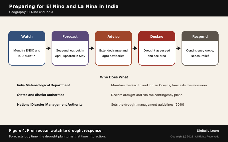
- Extended range forecasts: Updated every week for the next four weeks, to catch dry and wet spells inside the season.
- Agro advisories: Agriculture-specific advisories help farmers prepare for the heavy rain or drought of El Nino and La Nina years, guiding crop selection, irrigation, pest and disease warnings.
- Ocean forecasts: The Indian National Centre for Ocean Information Services runs its own ENSO prediction system and ocean state forecasts for coastal states.
The forecasts now read ENSO well enough to plan around. In 2023 the department predicted from April that El Nino would have no impact in the first half of the season but could hurt the second half, which is what happened, and the season's 94 per cent fell within its forecast of 96 per cent with a model error of 4 per cent. That is the lead time that drought planning depends on.
NDMA Drought Guidelines 2010 and Drought Declaration
The response side is set by the National Disaster Management Guidelines: Management of Drought, issued by the NDMA in September 2010. They note a clear association between El Nino and La Nina events and weak monsoons, and they mark a shift from a reactive, relief-centric approach to one of prevention, mitigation and preparedness.
- Drought week: Rainfall in a week less than half of its normal amount.
- Agricultural drought: Four drought weeks in a row between mid-June and September.
- Drought year: Annual rainfall deficient by 20 per cent of normal or more; a severe drought year is deficient by 25 to 40 per cent or more.
Around these definitions the guidelines build a chain of action. Drought-prone blocks are delineated using long-term rainfall, cropping pattern, available irrigation and satellite indicators; drought is assessed and declared by standard procedures; and an India Drought Management Centre and a control room for drought management are set up, with Drought Monitoring Cells in the states.
- Contingency plans: A contingency plan for a late monsoon or dry spells, with a suitable cropping pattern.
- Seeds: Short-duration varieties made available on subsidy, and quality seed stocked in advance.
- Farm practices: Awareness of intercropping, mulching and weed control to save soil moisture.
- Insurance and relief: Crop insurance and relief measures to protect farmers’ incomes.
Previous Year UPSC-CSE Questions
Previous Year UPSC-CSE Questions By the end you will be able to draft model answers for the following UPSC questions. Each question carries a collapsible framework showing how to approach it in the exam.
- UPSC Mains 2014 GS-IIIDrought has been recognized as a disaster in view of its spatial expanse, temporal duration, slow onset and lasting effects on vulnerable sections. With a focus on the September 2010 guidelines from the National Disaster Management Authority (NDMA), discuss the mechanisms for preparedness to deal with likely El Niño and La Niña fallouts in India.
Answer outline: how to structure the answer
What the question asks, the main arguments, relevant examples and the direction of the conclusion. This is not a full model answer.
Introduction: Drought is a slow-onset disaster; the NDMA's 2010 guidelines note a clear association between El Nino and La Nina events and weak monsoons, and shift India from relief to preparedness.
Body (sub-themes to develop):
- Early warning: IMD's monthly ENSO and IOD bulletin, April and May forecasts, extended range forecasts.
- Assessment: IMD definitions of drought week, agricultural drought and drought year; standard declaration.
- Institutions: India Drought Management Centre, drought control room, state Drought Monitoring Cells.
- Preparedness: delineation of drought-prone blocks, contingency crop plans, short-duration seeds.
- Mitigation and relief: soil-moisture practices, crop insurance, relief for the vulnerable.
- La Nina fallouts: floods and cold winters also need plans.
Conclusion: Conclude that forecasts now give months of warning, and the value of the guidelines lies in turning that warning into timely declaration and contingency action.
- UPSC Prelims 2011 Prelims-GSLa Nina is suspected to have caused recent floods in Australia. How is La Nina different from El Nino ?
- La Nina is characterised by unusually cold ocean temperature in equatorial Indian Ocean whereas El Nino is characterised by unusually warm ocean temperature in the equatorial Pacific Ocean.
- El Nino has adverse effect on south-west monsoon of India, but La Nina has no effect on monsoon climate.
Which of the statements given above is/are correct ?
How to approach this Prelims question
Approach: Check where La Nina happens and whether it affects India.
Trap to watch: La Nina is cold water in the Pacific, and it strongly affects the Indian monsoon.
Key facts to recall:
- (a) 1 only: wrong. Statement 1 is false: La Nina is unusually cool water in the central and eastern Pacific, not in the Indian Ocean.
- (b) 2 only: wrong. Statement 2 is false: La Nina years bring normal to above-normal Indian rain, so La Nina does affect the monsoon.
- (c) Both 1 and 2: wrong, since both statements are false.
- (d) Neither 1 nor 2: right. Both statements misstate La Nina: its cold water is in the Pacific, and it tends to strengthen the monsoon.
Answer signal: Neither statement is correct, option (d).
- UPSC Prelims 2002 Prelims-GSFor short-term climate prediction, which one of the following events, detected in the last decade, is associated with occasional weak monsoon rains in the Indian sub-continent?
How to approach this Prelims question
Approach: Pick the event linked to weak monsoon rains.
Trap to watch: La Nina goes with good monsoons.
Key facts to recall:
- (a) La Niña: wrong. La Nina years tend to bring normal to above-normal rain, not weak monsoons.
- (b) Movement of Jet Streams: wrong. The jet streams shift every year with the seasons; the event linked to occasional weak monsoons is El Nino.
- (c) El Niño and Southern Oscillations: right. Of 16 El Nino years since 1950, 7 brought below-normal rain, and an El Nino goes with a negative Southern Oscillation Index.
- (d) Greenhouse effects on global level: wrong. Global warming is a long-term change, not an event used for short-term prediction.
Answer signal: El Nino and Southern Oscillations, option (c).
- UPSC Prelims 2017 Prelims-GSWith reference to ‘Indian Ocean Dipole (IOD)’, sometimes mentioned in the news while forecasting Indian monsoon, which of the following statements is/are correct?
- IOD phenomenon is characterised by a difference in sea surface temperature between tropical Western Indian Ocean and tropical Eastern Pacific Ocean.
- An IOD phenomenon can influence an El Niño’s impact on the monsoon.
Select the correct answer using the code given below:
How to approach this Prelims question
Approach: Check which two regions the dipole compares.
Trap to watch: The IOD compares the western and eastern Indian Ocean, not the Indian and Pacific Oceans.
Key facts to recall:
- (a) 1 only: wrong. Statement 1 is false: the IOD compares the western and eastern Indian Ocean, not the Pacific.
- (b) 2 only: right. An IOD can change El Nino's effect; a positive IOD tends to bring above-average Indian rain.
- (c) Both 1 and 2: wrong, since statement 1 is false.
- (d) Neither 1 nor 2: wrong, since statement 2 is true.
Answer signal: Statement 2 only, option (b).
- UPSC Prelims 2010 Prelims-GSA new type of El Nino called El Nino Modoki appeared in the news. In this context, consider the following statements:
- Normal El Nino forms in the Central Pacific ocean whereas El Nino Modoki forms in Eastern Pacific ocean.
- Normal El Nino results in diminished hurricanes in the Atlantic ocean but El Nino Modoki results in a greater number of hurricanes with greater frequency.
Which of the statements given above is/are correct?
How to approach this Prelims question
Approach: Place each type in the right part of the Pacific, then recall the hurricane contrast.
Trap to watch: The statement swaps the locations: normal El Nino is eastern Pacific, Modoki is central Pacific.
Key facts to recall:
- (a) 1 only: wrong. Statement 1 swaps the locations: a normal El Nino warms the eastern Pacific and El Nino Modoki the central Pacific.
- (b) 2 only: right. Normal El Nino years bring fewer Atlantic hurricanes, while El Nino Modoki brings more hurricane landfalls.
- (c) Both 1 and 2: wrong, since statement 1 is false.
- (d) Neither 1 nor 2: wrong, since statement 2 is true.
Answer signal: Statement 2 only, option (b).
Sources
- NCERT: India Physical Environment (Class XI), Climate
- NCERT: India People and Economy (Class XII), Land Resources and Agriculture
- IMD: 2023 Southwest Monsoon End of Season Report
- PIB (Ministry of Earth Sciences): El Nino effect on monsoon and rainfall, Lok Sabha, 11 December 2024
- PIB (Ministry of Earth Sciences): Impact of La Nina on climate patterns, Lok Sabha, 2 April 2025
- PIB (Ministry of Earth Sciences): El Nino and its monsoon impact, Lok Sabha, 5 August 2026
- PIB: IMD updated long range forecast for the 2026 south-west monsoon, 29 May 2026
- PIB: The Indian Monsoon, Nature's Pulse and Nation's Lifeline, 15 July 2025
- NDMA: National Disaster Management Guidelines, Management of Drought, September 2010
- NOAA Climate.gov: El Nino and La Nina, frequently asked questions
- NOAA: Understanding El Nino
- Wikipedia: El Niño–Southern Oscillation
- Wikipedia: 2023–2024 El Niño event
- Wikipedia: Drought in India
- Wikipedia: Indian Ocean Dipole
- Wikipedia: Walker circulation
- Wikipedia: Monsoon of South Asia
- UPSC: Civil Services Examination question papers
Editorial Disclaimer
This article draws on the NCERT geography textbooks, the India Meteorological Department, the Press Information Bureau, the NDMA and the other sources listed on this page. Forecasts quoted are those published before the season ended.