
Overview
Rainfall, Temperature, Pressure-Wind, and Local Weather
India's four climatic elements read together: rainfall belts and types, the January 18C isotherm, the seasonal pressure-wind reversal, and named local-weather phenomena.
Previous Year UPSC-CSE Questions By the end you will be able to draft model answers for the following UPSC questions. Each question carries a collapsible framework showing how to approach it in the exam.
- UPSC Prelims 1997The January isotherm taken as a basis for dividing India into tropical and sub-tropical zones is
How to approach this Prelims question
Approach: The 18 degrees Celsius January isotherm is the textbook line dividing India into the tropical south (above 18C in January) and the sub-tropical north (below 18C in January). The other temperature values are distractors.
Trap to watch: 21 degrees Celsius (option a) is the mean daily temperature threshold for the cold-weather season in north India, not the isotherm divide.
Key facts to recall:
- January 18 degrees Celsius isotherm divides tropical (south) from sub-tropical (north) India
- Mean daily temperature below 21 degrees Celsius defines the cold-weather season in north India
- Isotherms run parallel to the coast on the peninsular subcontinent
Answer signal: Correct answer is (b) (18 degrees Celsius).
- UPSC Prelims 2024Which of the following is/are correct inference/inferences from isothermal maps in the month of January?
- The isotherms deviate to the north over the ocean and to the south over the continent.
- The presence of cold ocean currents, Gulf Stream and North Atlantic Drift make the North Atlantic Ocean colder and the isotherms bend towards the north. Select the answer using the code given below:
How to approach this Prelims question
Approach: Statement 1: in January in the Northern Hemisphere, isotherms bend NORTHWARD over the warmer ocean and SOUTHWARD over the cooler continent because the ocean retains heat longer (differential heating) – CORRECT. Statement 2: the Gulf Stream and North Atlantic Drift are WARM currents originating in the tropical Atlantic and travelling north-east; they make the North Atlantic WARMER, not colder – INCORRECT. The factual error in Stmt 2 is the current-temperature characterisation.
Trap to watch: Stmt 2 inverts the Gulf Stream / North Atlantic Drift temperature character; they are warm not cold currents.
Key facts to recall:
- January isotherms bend north over ocean (warmer) and south over continent (cooler)
- Gulf Stream and North Atlantic Drift are WARM ocean currents
- Warm currents bend isotherms toward the poles; cold currents bend isotherms toward the equator
Answer signal: Correct answer is (a) (1 only).
- UPSC Prelims 2007Consider the following statements:
- Either of the two belts over the ocean at about 30 to 35 degrees N and S latitudes is known as Horse Latitude.
- Horse Latitudes are low-pressure belts.
Which of the statements given above is/are correct?
How to approach this Prelims question
Approach: Statement 1: Horse Latitudes are the subtropical belts at 30-35 degrees North and South latitudes over the ocean – CORRECT. Statement 2: Horse Latitudes are SUBTROPICAL HIGH-PRESSURE belts (sinking dry air from the descending limb of the Hadley cell), not low-pressure – INCORRECT. The world's hot deserts (Thar, Sahara, Atacama, Kalahari, Great Australian) lie under the Horse Latitudes.
Trap to watch: Stmt 2 inverts the pressure character; Horse Latitudes are high not low pressure.
Key facts to recall:
- Horse Latitudes 30-35 degrees N/S; subtropical high-pressure belts
- Descending limb of the Hadley cell drives sinking dry air
- World's hot deserts (Thar, Sahara, Atacama, Kalahari, Great Australian) lie under Horse Latitudes
Answer signal: Correct answer is (a) (1 only).
- UPSC Mains 2021 GS-IBriefly mention the alignment of major mountain ranges of the world and explain their impact on local weather conditions, with examples.
How to structure the answer in the exam
Introduction: Define the four canonical alignment patterns of major mountain ranges (north-south, east-west, arc, and oblique), and state that alignment is the first-order control on regional weather through orographic uplift and rain-shadow effects.
Body (sub-themes to develop):
- Himalaya (east-west): shields India from central-Asian cold winds and forces orographic uplift of the south-west monsoon on its windward south face, shaping the Indo-Gangetic climate.
- Western Ghats (north-south): orographic rainfall on the windward Konkan-Malabar coast against a pronounced Deccan rain-shadow on the leeward interior.
- Rockies and Andes (north-south): drive the Pacific-versus-interior climate asymmetry of the Americas; the Andes create the hyper-arid Atacama rain-shadow.
- General principle: windward slopes are wet, leeward slopes are dry; alignment relative to prevailing winds decides the pattern, with latitude and altitude as second-order modifiers.
Conclusion: Conclude that mountain alignment is the primary geographic control on local weather, with the Himalaya and the Western Ghats furnishing the clearest Indian illustrations.
The climatic elements of India are the four measurable variables that describe the country's lived climate: rainfall (distribution patterns plus three rainfall types of orographic, convectional, and cyclonic), temperature (organised around the January 18 degrees Celsius isotherm that divides tropical and sub-tropical India), pressure and wind (seasonal high-low reversal between January north-western high and July monsoon trough at 20 to 25 degrees North), and local weather phenomena (Loo, Kalbaisakhi or Norwesters, Mango showers, Cherry blossom showers, Bardoli Chheerha). Each element shows extreme spatial heterogeneity from Mawsynram's 11,000 millimetres of annual rainfall to Jaisalmer's under 200 millimetres.
Background and Historical Context
The four climatic elements together produce India's lived climate. The kharif and rabi cropping calendars depend on rainfall distribution and timing; the heat-wave health emergencies of May depend on the temperature regime; the ITCZ migration and pressure-pattern reversal drive the southwest monsoon mechanism explained in Climate Part 3; and the named local-weather phenomena calibrate the IMD seasonal forecasting service. UPSC Prelims has tested isothermal maps, pressure belts, and Horse Latitudes in 2024, 2007, 1997, and earlier years; Mains GS-I treats local weather as the foundation for regional climatic geography.
What is the significance of treating the four elements together? Each element is the surface expression of one underlying climatic driver: rainfall expresses the southwest-monsoon moisture-supply mechanism, temperature expresses the latitude-and-altitude pattern, pressure-wind expresses the seasonal-circulation reversal, and local weather expresses the regional convective and frontal systems. Reading them in sequence reveals why India is a tropical-monsoon country with regional micro-climates rather than a single uniform climatic system.
The IMD long-period rainfall record since 1901 documents the all-India and sub-divisional rainfall distribution. The ISRO Bhuvan rainfall and temperature maps provide the operational visualisation layer. The NDMA heat-action plan framework calibrates red-alert protocols to the May temperature regime and the Loo wind window. Sector linkages run across agriculture (cropping calendar), water resources (reservoir filling), energy (cooling-demand peak), and public health (heat-stress mortality).
Introduction: Spatial Heterogeneity of India's Climate
The four-element framework
India's climate varies sharply across the subcontinent in four observable elements: rainfall, temperature, pressure and wind, and local weather phenomena. Each element has its own spatial distribution pattern, its own seasonal regime, and its own measurement framework built on the IMD's century-long observational record. Reading the four elements together produces the lived picture of India's tropical-monsoon climate that Parts 1 through 4 of this series explain mechanistically.
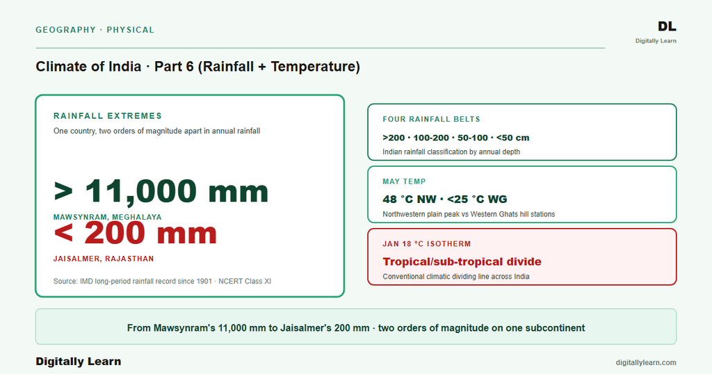
The spatial heterogeneity is extreme. Mawsynram in the Meghalaya hills receives over 11,000 millimetres of rainfall annually; Jaisalmer in western Rajasthan receives under 200 millimetres. May temperatures in the northwestern plain reach 48 degrees Celsius while Western Ghats hill stations remain below 25 degrees. The January 18 degrees Celsius isotherm is conventionally taken as the dividing line between India's tropical and sub-tropical climatic zones.
Rainfall: Distribution and Types
The four rainfall belts
Three quarters of India's annual rainfall arrives in the southwest monsoon window, and its spatial distribution determines agricultural cropping patterns, hydropower-reservoir filling, groundwater recharge, and drought-flood vulnerability. UPSC Prelims has tested rainfall distribution, isotherms, and pressure belts repeatedly across decades; Mains GS-I treats rainfall regimes as the foundation for regional climatic geography.
- Very heavy rainfall belt (above 200 cm): Windward Western Ghats, the sub-Himalayan tract, north-east India including Meghalaya hills (Mawsynram and Cherrapunji), and Andaman-Nicobar islands.
- Heavy rainfall belt (100 to 200 cm): Bihar, eastern Madhya Pradesh, the northern Ganga plain, the Coromandel coast, and the windward slopes of the Aravallis.
- Moderate rainfall belt (50 to 100 cm): Western Uttar Pradesh, Punjab, Haryana, parts of Gujarat, the Deccan plateau interior.
- Low rainfall belt (below 50 cm): Western Rajasthan including Jaisalmer, leeward Western Ghats including Pune-Solapur, parts of Ladakh and the rain-shadow of Kashmir.
Three types of rainfall and their Indian expression
Why the three rainfall types must be distinguished. Each rainfall type has a different trigger mechanism, a different spatial signature on the Indian map, and a different policy response. Conflating the three is the principal failure mode in UPSC answers on regional climate.
- (i) Orographic rainfall: Moist maritime air forced to rise over a mountain barrier cools and precipitates on the windward slope; the leeward slope is the rain shadow. The Western Ghats windward (Konkan, Malabar) and the Himalayan front are the dominant Indian orographic systems.
- (ii) Convectional rainfall: Surface heating drives moist air to rise, cool, and precipitate as short-duration high-intensity thunderstorm rain. North-east India’s pre-monsoon Kalbaisakhi and Kerala’s Mango showers are convectional. The peninsular plateau receives convectional rainfall throughout the summer.
- (iii) Cyclonic (frontal) rainfall: Pressure-front systems lift warm-moist air over cool-dry air at the front; rainfall is widespread and prolonged. Bay of Bengal tropical cyclones in October-November and Mediterranean western disturbances in December-February deliver India’s cyclonic rainfall.
Temperature Regime and the January Isotherm
Isotherm pattern and the tropical / sub-tropical divide
The January isotherm of 18 degrees Celsius conventionally divides India into a tropical south and a sub-tropical north. In January, the northern plain remains below 21 degrees Celsius mean daily temperature, while peninsular India remains 26 to 32 degrees Celsius because of the moderating ocean. The May isotherms migrate northward as the heat-low forms; temperatures reach 48 degrees Celsius in the north-western plain while Western Ghats hills remain below 25 degrees.
Observable outcomes from the isotherm pattern include the predictable seasonal contrast that defines the kharif-rabi calendar, the moderate coastal climate that supports year-round cropping, and the extreme continental interior climate that limits the agricultural season.
- (a) Maritime moderation: Isotherms run parallel to the coast on the peninsular subcontinent because the sea moderates coastal temperatures across the seasons.
- (b) Continental extreme: Interior districts show wide diurnal and seasonal temperature ranges because the landmass heats and cools rapidly.
- (c) Altitude effect: Temperature falls approximately 1 degree Celsius per 165 metres of elevation (the environmental lapse rate), keeping the Western Ghats and Himalayan hill stations 10 to 15 degrees cooler than the adjoining plain at the same latitude.
Pressure and Wind Patterns
Seasonal pressure-belt shifts and the monsoon trough
India's surface pressure pattern flips between winter and summer. In January, a feeble high-pressure cell sits over the north-western plain, with isobars of 1019 millibar and 1013 millibar passing through north-west India and the far south respectively; winds blow outward at 3 to 5 kilometres per hour.
By mid-July, the Inter Tropical Convergence Zone migrates to 20 to 25 degrees North as the monsoon trough. This low-pressure axis draws the maritime tropical airmass northward across the equator, which arrives over the subcontinent as the southwest monsoon.
- Equatorial low-pressure belt: 0 to 5 degrees N/S; rising warm air; doldrums calm-belt; near-permanent convectional rainfall.
- Subtropical high-pressure belts (Horse Latitudes): 30 to 35 degrees N/S over the ocean; sinking dry air; the world’s deserts including the Thar lie under these belts.
- Sub-polar low-pressure belt: 60 to 65 degrees N/S; rising air at the polar-front; storm-track region.
- Polar high-pressure belt: 80 to 90 degrees N/S; cold dense sinking air.
Local Weather Phenomena
Five named local weather phenomena
Five named local-weather phenomena are part of the canonical UPSC vocabulary, each tied to a specific region and season. The IMD seasonal forecasts and NDMA heat-wave action plans calibrate to these named regimes; misidentifying them is the principal failure mode in the regional-climate Prelims and Mains questions.
| Phenomenon | Region | Season | Character and impact |
|---|---|---|---|
| Loo | North-west plains (Rajasthan to Bihar) | May to June | Hot, dry, daytime continental wind; raises heat-stroke risk |
| Kalbaisakhi (Norwester) | West Bengal, Assam, Odisha | April to May (pre-monsoon) | Violent evening thunderstorm; aids jute and rice nurseries |
| Mango showers | Kerala, coastal Karnataka | April to May | Pre-monsoon showers that help ripen mangoes and coffee |
| Western disturbances | North-west India, Punjab plains | December to February | Extra-tropical cyclones bringing winter rain to rabi wheat |
- Loo: Hot, dry, dust-laden surface wind over the northern and north-western plain in May and June; raises temperatures into the 45 to 48 degrees Celsius heat-wave range and triggers NDMA red-alert protocols.
- Kalbaisakhi (Norwesters): Violent April-May thunderstorms over West Bengal, Assam, and Odisha that deliver short, intense rainfall with damaging hailstorms; convectional in mechanism.
- Mango showers: Pre-monsoon thunderstorm rains over the Kerala and coastal Karnataka coast in March and April that help ripen the mango crop.
- Cherry blossom showers: Pre-monsoon thunderstorm rains over Karnataka’s coffee tracts in March that initiate flowering on the coffee plants.
- Bardoli Chheerha: The Assamese name for the pre-monsoon Nor’wester (Kalbaisakhi) thunderstorms of Bengal and Assam, valued for nurturing jute and early paddy.
Prelims MCQ practice
Each question below tests one specific concept on the topic. Click to reveal the answer and a full option-wise explanation.
Q1. Consider the following statements about rainfall distribution in India:
- Mawsynram and Cherrapunji (Meghalaya) are among the wettest places on Earth, receiving over 11,000 mm of annual rainfall.
- Western Rajasthan and the leeward side of the Western Ghats receive less than 250 mm of annual rainfall in places.
- The rain-shadow region east of the Western Ghats includes parts of inland Karnataka, Telangana, and Andhra Pradesh.
Which of the statements given above are correct?
- 1 and 2 only
- 2 and 3 only
- 1 and 3 only
- 1, 2 and 3
Show answer and explanation
Answer: 1, 2 and 3
Explanation.
Correct: d (1, 2 and 3). All three are correct. Mawsynram and Cherrapunji in Meghalaya are among the wettest places on Earth (Mawsynram has held the world's wettest place record), receiving over 11,000 mm annually. Western Rajasthan and leeward side of Western Ghats can receive under 250 mm annually. The rain-shadow east of the Western Ghats covers inland Karnataka, Telangana, and parts of AP.
Q2. Consider the following statements about temperature extremes in India:
- Western Rajasthan (e.g., Phalodi, Churu) records the highest summer maximum temperatures in India, often exceeding 50 deg C.
- Drass (Ladakh) and Leh record some of India's lowest winter minimum temperatures, often well below minus 30 deg C.
Which of the statements given above is/are correct?
- 1 only
- 2 only
- Both 1 and 2
- Neither 1 nor 2
Show answer and explanation
Answer: Both 1 and 2
Explanation.
Correct: c (Both 1 and 2). Both statements are correct. Western Rajasthan (Phalodi, Churu, Bikaner) records India's highest summer maximums, often exceeding 50 deg C; Phalodi recorded 51.0 deg C on 19 May 2016 (the historic Indian record). Drass (Ladakh) and Leh record India's lowest winter minimums, often well below minus 30 deg C (Drass has recorded minus 40 deg C at times).
Q3. Consider the following statements about local winds in India:
- 'Mango showers' are pre-monsoon thundershowers along the Kerala-Karnataka coast that help mango ripening.
- 'Cherry blossom showers' over Karnataka coffee tracts help coffee blossoming and bean development.
- 'Bardoli Chheerha' refers to summer winds in coastal Maharashtra.
Which of the statements given above are correct?
- 1 and 2 only
- 2 and 3 only
- 1 and 3 only
- 1, 2 and 3
Show answer and explanation
Answer: 1 and 2 only
Explanation.
Correct: a (1 and 2 only). Statement 1 is correct: mango showers help mango ripening. Statement 2 is correct: cherry blossom showers help coffee blossoming in Karnataka coffee tracts. Statement 3 is wrong: 'Bardoli Chheerha' is the Assamese name for the pre-monsoon Nor'wester (Kalbaisakhi) thunderstorms of Bengal and Assam, not summer winds in coastal Maharashtra.
Q4. Consider the following statements about rainfall variability in India:
- Coefficient of variation (CV) of annual rainfall is highest in low-rainfall areas (western Rajasthan, parts of Gujarat) and lowest in high-rainfall areas (Western Ghats, NE India).
- Inter-annual variability of southwest monsoon rainfall is a major driver of agricultural production and food security in India.
Which of the statements given above is/are correct?
- 1 only
- 2 only
- Both 1 and 2
- Neither 1 nor 2
Show answer and explanation
Answer: Both 1 and 2
Explanation.
Correct: c (Both 1 and 2). Both statements are correct. CV of annual rainfall is highest in low-rainfall arid areas (western Rajasthan, parts of Gujarat) and lowest in high-rainfall areas (Western Ghats, NE India). Inter-annual SW monsoon variability is the most important driver of agricultural production and food security in India.
Q5. Consider the following statements about rainfall sources in India:
- The Southwest monsoon (June-September) contributes around 75-80 per cent of India's total annual rainfall.
- The Northeast monsoon (October-December) and Western Disturbances are the secondary rainfall sources.
Which of the statements given above is/are correct?
- 1 only
- 2 only
- Both 1 and 2
- Neither 1 nor 2
Show answer and explanation
Answer: Both 1 and 2
Explanation.
Correct: c (Both 1 and 2). Both statements are correct. The Southwest monsoon contributes around 75-80 per cent of India's annual rainfall total (the dominant rainfall source). The Northeast monsoon and Western Disturbances are the secondary rainfall sources, contributing roughly 10-13 per cent and the balance respectively.
Q6. Consider the following statements about temperature distribution in India:
- In January (winter), isotherms generally run east-west, reflecting latitudinal control on temperature.
- Coastal areas have a smaller annual temperature range than continental interior areas because of maritime moderating influence.
Which of the statements given above is/are correct?
- 1 only
- 2 only
- Both 1 and 2
- Neither 1 nor 2
Show answer and explanation
Answer: Both 1 and 2
Explanation.
Correct: c (Both 1 and 2). Both statements are correct. In January, India's isotherms run roughly east-west, reflecting latitudinal temperature control (north colder than south). Coastal areas have smaller annual temperature ranges than continental interior areas due to maritime moderation (Mumbai vs Nagpur is a classic example).
Sources
- NCERT Class 11 India Physical Environment, Chapter 4 (Climate)
- India Meteorological Department (IMD) long-period rainfall archive
- Indian Institute of Tropical Meteorology (IITM), Pune
- ISRO Bhuvan rainfall and temperature visualisation
- NOAA Climate Prediction Center
- Wikipedia: Climate of India
- Wikipedia: Mawsynram
- Wikipedia: Cherrapunji
- Wikipedia: Loo (wind)
- Wikipedia: Horse latitudes
Disclaimer
This article supports UPSC – CSE preparation and covers India's four climatic elements: rainfall distribution and types, the temperature regime, pressure and wind patterns, and named local-weather phenomena. Key concepts and named figures are cross-verified with NCERT and the authoritative sources listed in the Sources block. For any correction, please write to us.


