


Overview
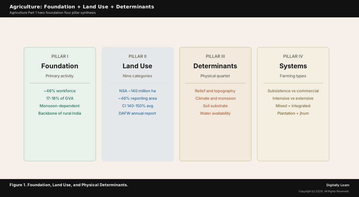
Agriculture is the primary economic activity involving the cultivation of crops and the rearing of livestock for food, fibre, and other raw materials. In India agriculture remains the backbone of the rural economy, engaging roughly 46 per cent of the workforce per the Periodic Labour Force Survey 2023-24 and contributing around 17 to 18 per cent of Gross Value Added. The Indian Council of Agricultural Research and the Ministry of Agriculture classify land into nine land-use categories, of which net sown area is the actively cultivated tract (approximately 140 million hectares, around 46 per cent of the country's reporting area). Productivity outcomes are shaped by the interaction of relief, climate, soil, and water, the four physical determinants that this article links to the per-substrate Soils cluster and to the Climate of India cluster.
Background and Historical Context
Agriculture underwrites India's food security, rural livelihoods, and a substantial share of the export economy. UPSC GS-I treats agricultural geography as the foundation chapter for cropping patterns, irrigation, marketing, and policy questions; GS-III covers production, technology, and subsidies. The Soils cluster (Parts 2 through 9) supplies the substrate; this Agriculture cluster supplies the cropping system; the Climate cluster supplies the monsoon regime that drives both.
What is the significance of the foundation chapter? Three operational dimensions follow. The land-use category framework (forest, non-agricultural use, barren and wasteland, permanent pastures, tree crops, culturable wasteland, fallow, net sown area) is the analytical grid that every Indian agricultural geography question runs on. The cropping intensity formula (gross cropped area divided by net sown area, multiplied by 100) measures how intensively the same tract is double or triple cropped; Indian average sits around 140 to 150 per cent and rises above 180 per cent in irrigated Punjab-Haryana. The physical-determinant quartet (relief, climate, soil, water) determines where each crop can be grown and at what yield, the foundation that the remaining Agriculture cluster parts build on.
The Department of Agriculture and Farmers Welfare under the Ministry of Agriculture publishes the Land Use Statistics at a Glance annual report; the Indian Council of Agricultural Research coordinates research; the Agricultural and Processed Food Products Export Development Authority regulates the export segment. The National Statistical Office under MoSPI produces the Situation Assessment Survey of Agricultural Households that anchors household-level analysis. Climate-change amplification of monsoon variability is the single largest contemporary stressor on the foundation; the Indian Council of Agricultural Research's National Innovations in Climate Resilient Agriculture (NICRA) programme is the canonical adaptation response.
Introduction: Agriculture as the Primary Economic Activity
Definition, workforce share, GDP contribution
Agriculture is the primary economic activity through which human communities directly engage with the natural environment to produce food, fibre, and biological raw materials. The activity covers crop cultivation, livestock rearing, fisheries, horticulture, and forestry. In economic-geography terms it is the principal occupation of the primary sector, distinct from the secondary sector (manufacturing) and the tertiary sector (services).
India ranks among the world's largest agricultural economies by absolute output. Agriculture engages roughly 46 per cent of the working population per the Periodic Labour Force Survey 2023-24 and contributes around 17 to 18 per cent of Gross Value Added. The gap between the high workforce share and the lower output share reflects low per-worker productivity relative to manufacturing and services, the central policy puzzle this cluster revisits later.
Land Use Categories: The Nine-Way Classification
How the Department of Agriculture classifies Indian land
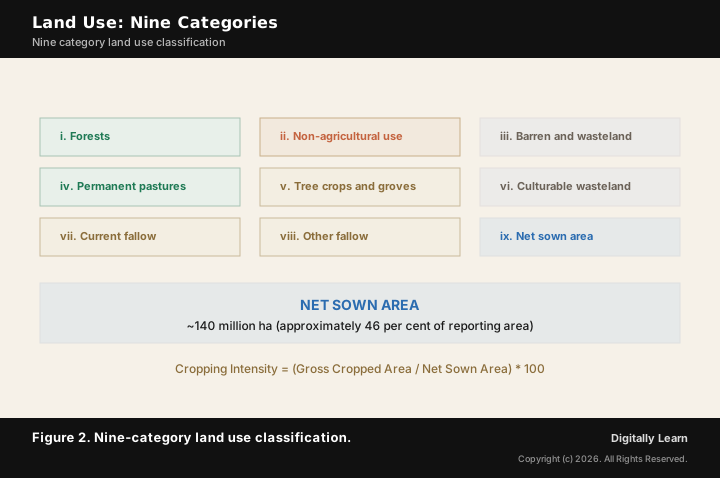
Every Indian agricultural statistic begins with the nine-way land-use classification published by the Department of Agriculture and Farmers Welfare. The categories collectively cover the country's reporting area and supply the denominator for productivity, cropping intensity, and policy-effort metrics.
- (i) Forests: Area classified as forest under any law; not necessarily under tree cover but legally demarcated.
- (ii) Area under non-agricultural uses: Land occupied by settlements, roads, railways, industrial sites, and water bodies.
- (iii) Barren and wasteland: Mountainous, rocky, and arid tracts unsuited to cultivation by current technology.
- (iv) Area under permanent pastures and grazing lands: Mostly common-property pastoral commons.
- (v) Area under miscellaneous tree crops and groves: Mango, casuarina, and orchards not classified as net sown area.
- (vi) Culturable wasteland: Land available for cultivation but not actually cultivated currently.
- (vii) Current fallow: Land left uncultivated for one year or less.
- (viii) Fallow other than current fallow: Land uncultivated for more than one year but less than five years.
- (ix) Net sown area: The physical extent of land on which crops are actually sown and harvested in the reporting year; approximately 140 million hectares for India.
The gross cropped area is the net sown area plus the area sown more than once in the same year. The ratio of gross cropped area to net sown area, multiplied by 100, gives the cropping intensity measure that captures how intensively the same physical land is double or triple cropped. The national average sits around 140 to 150 per cent; canal-irrigated Punjab and Haryana reach above 180 per cent.
Physical Determinants: Relief, Climate, Soil, Water
How the four physical factors shape agricultural geography
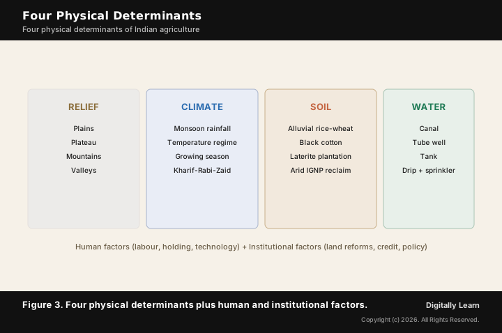
How the determinant quartet shapes the agricultural map. Indian agricultural geography is a joint outcome of four physical determinants. Each one alone constrains crop choice; together they explain why the rice-wheat rotation dominates the Indo-Gangetic plain, cotton dominates the Deccan Vertisols, and tea-coffee dominate the Western Ghats laterite slopes.
- (i) Relief and topography: Flat plains (Indo-Gangetic, coastal) support large mechanised farms; plateaus (Deccan, Chota Nagpur) support dry-farming and plantation; mountains (Himalayan, Western Ghats) support terrace farming and horticulture; river valleys carry intensive cropping with fresh alluvium replenishment.
- (ii) Climate: Monsoon rainfall distribution, temperature regime, and growing season together fix the crop calendar. The kharif-rabi-zaid sequence is anchored to the monsoon arrival and retreat. Cross-anchor to the Climate of India cluster Parts 4 through 7.
- (iii) Soil: The eight soil types covered in Soils Parts 2 through 8 each carry a characteristic crop signature. Alluvial supports rice-wheat-sugarcane; Black Soil supports cotton; Red and Laterite support millets-pulses and plantation; Arid carries bajra rain-fed and reclaimed cotton-wheat under IGNP; Mountain soils carry tea-coffee-apple-spices; Peaty supports rice on Kuttanad below-sea-level paddy.
- (iv) Water: Monsoon-fed rain-fed agriculture covers approximately half the cropped area; the remainder depends on irrigation from canals, tubewells, tanks, and increasingly micro-irrigation. Cross-anchor to Agriculture Part 8 on Irrigation.
| Soil or region | Dominant crop signature | Leading physical determinant |
|---|---|---|
| Alluvial (Indo-Gangetic plain) | Rice, wheat, sugarcane | Level relief and assured water |
| Black or regur (Deccan trap) | Cotton, soybean, pulses | Moisture-retentive soil |
| Red (Peninsular crystalline) | Millets, pulses, groundnut | Rain-fed climate |
| Laterite (Western Ghats) | Tea, coffee, cashew, rubber | Heavy monsoon rainfall |
| Arid (north-west) | Bajra rain-fed; cotton-wheat under IGNP | Irrigation water availability |
Two additional determinant categories operate alongside the physical quartet. Human factors cover labour supply, land holdings, technology adoption, and risk appetite; institutional factors cover land reforms, credit access, cooperative networks, and policy support. The Agriculture cluster Parts 9 (inputs and technology) and 10 (marketing and policy) cover these in depth.
Subsistence versus Commercial: Types of Indian Farming
How farming systems are classified by purpose and scale
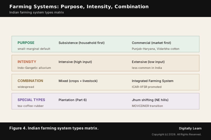
Observable outcomes shape the farming-system geography. Indian farming systems are classified by the purpose of production, the scale of holding, and the intensity of input use. The three operational distinctions below frame every regional case study in the remainder of this cluster.
- (a) Subsistence versus commercial: Subsistence farming targets household consumption first, marketing the surplus; the dominant mode across small-and-marginal Indian farms. Commercial farming targets market sale, with crops chosen for export or processing value; Punjab-Haryana rice-wheat, Vidarbha cotton, Kerala rubber, and Maharashtra sugarcane are canonical examples.
- (b) Intensive versus extensive: Intensive farming applies high input per unit area (irrigation, fertiliser, labour, machinery) for high yields; characteristic of Indo-Gangetic alluvial belt. Extensive farming spreads inputs thinly across large holdings; less common in India given small average holding size.
- (c) Mixed and integrated farming: Mixed farming combines crop cultivation with livestock rearing on the same holding; widespread across India. Integrated Farming Systems extend the concept to include fisheries, poultry, and agroforestry; promoted by ICAR for small and marginal farmers (Mains 2022 and 2019 GS-III tested IFS directly).
Plantation agriculture is a separate category covered in Agriculture Part 6 (Tea, Coffee, Rubber). Shifting cultivation (jhum) is a third historical mode that Agriculture Part 2 covers in the north-eastern hill context. The Indo-Burma jhum tradition is in active transition under MOVCDNER toward settled organic farming.
Policy Foundation and Contemporary Architecture
Institutions, programmes, and the cluster roadmap
The Department of Agriculture and Farmers Welfare is the central coordinating body, while the Indian Council of Agricultural Research leads the research network. The Export Development Authority (APEDA) regulates exports, the National Bank for Agriculture and Rural Development finances rural credit, and the commodity boards (Cotton, Coffee, Tea, Rubber, Spices, Cashew) regulate the plantation segments covered in Agriculture Part 6.
- Land Use Statistics at a Glance: Annual report published by Department of Agriculture and Farmers Welfare is the authoritative land-use dataset.
- Periodic Labour Force Survey: By MoSPI tracks workforce share across primary, secondary, and tertiary sectors annually.
- Situation Assessment Survey of Agricultural Households: By NSO captures household-level income, indebtedness, and land holding.
- National Innovations in Climate Resilient Agriculture (NICRA): Coordinated by ICAR addresses monsoon-variability adaptation; networked across over 100 Krishi Vigyan Kendras.
- Soil Health Card scheme (covered in Soils Part 9) delivers farm-level nutrient profiles; drives integrated soil management.
The remaining Agriculture cluster parts build on this foundation. Parts 2 through 6 cover regional patterns and specific crops. Part 7 covers horticulture, livestock, and fisheries. Part 8 covers irrigation. Part 9 covers inputs and technology. Part 10 covers marketing and policy. Part 11 covers dryland, sustainable, and climate-change agriculture. Part 12 closes with the agricultural-revolutions overview, rural economy, and contemporary model frameworks.
Previous Year UPSC-CSE Questions
Previous Year UPSC-CSE Questions By the end you will be able to draft model answers for the following UPSC questions. Each question carries a collapsible framework showing how to approach it in the exam.
- UPSC Prelims 2006Read the following Assertion (A) and Reason (R) and choose the correct option:
- Assertion (A): The percentage of net sown area in the total area of Andhra Pradesh is less as compared to that of West Bengal.
- Reason (R): The soil of most of Andhra Pradesh is laterite.
In the context of the above statements, which one of the following is correct?
How to approach this Prelims question
Approach: Verify the assertion first: West Bengal sits on the Ganga-Brahmaputra alluvial delta with very high cultivation intensity, while Andhra Pradesh covers the Deccan plateau, Eastern Ghats, and coastal plain. Andhra Pradesh therefore has a lower NSA percentage. Now verify the reason: laterite soils dominate the Western Ghats coastal belt, NOT Andhra Pradesh. Andhra Pradesh carries red soil on crystalline rock (Soils Part 4) plus alluvium on coastal deltas. Reason is false.
Trap to watch: Tempting to accept the reason because both AP and laterite are associated with peninsular India; the geographic distinction is that laterite needs heavy rainfall (Western Ghats) while AP's interior is rain-shadow red soil.
Key facts to recall:
- Net sown area percentage varies by state terrain, climate, and soil
- West Bengal alluvial delta carries high NSA percentage
- Andhra Pradesh Deccan plateau and Eastern Ghats lowers NSA percentage
- Andhra Pradesh dominant soil is RED (Soils Part 4), NOT laterite
- Laterite dominates Western Ghats coastal belt under heavy rainfall
Answer signal: Correct answer is (c): A true, R false.
Sources
- NCERT Class 12 India People and Economy, Chapter 5 (Land Resources and Agriculture)
- NCERT Class 12 Fundamentals of Human Geography, Chapter 5 (Primary Activities)
- Indian Council of Agricultural Research (ICAR)
- Department of Agriculture and Farmers Welfare, Ministry of Agriculture
- Ministry of Statistics and Programme Implementation (MoSPI)
- Agricultural and Processed Food Products Export Development Authority (APEDA)
- Ministry of Agriculture and Farmers Welfare, Soil Health Card
- United Nations Food and Agriculture Organization (FAO)
- Wikipedia: Agriculture in India
- Wikipedia: Land use statistics by country
Disclaimer
This article explains Indian agriculture as the primary economic activity, the nine-category land-use classification, the cropping intensity measure, and the four physical determinants of agricultural geography. Named institutions, figures, and classifications are cross-verified against NCERT and the authoritative sources listed in the Sources block below. Readers should consult the latest government releases for current-year statistics.