


Overview
Harappan town planning is the deliberate design of a settlement's mounds, streets, houses, drains and water works before and during construction, so that the whole city follows one scheme. The urban phase of the civilisation, the Mature Harappan phase, ran from 2600 BCE to 1900 BCE. Most of the cities discussed here belong to it; the Early Harappan phase before it ran from 6000 BCE to 2600 BCE, and at Kalibangan the Early Harappan settlement was already fortified.
Planned Cities of the Mature Harappan Phase
Evidence That the Cities Were Planned
Harappa was the first site discovered, but Mohenjo-daro was far better preserved, so it becomes the model city for study; Harappa was badly destroyed by brick robbers. Alexander Cunningham noted in 1875 that the brick taken from the site was enough to lay about 100 miles of railway line between Lahore and Multan.
A settlement that grows by accident does not look like Mohenjo-daro. Two lines of evidence show that its builders had a scheme in mind.
The first is the labour involved. The citadel owes its height to buildings raised on mud-brick platforms, and several buildings of the lower town also stood on platforms that served as foundations. It has been calculated that if one labourer moved roughly a cubic metre of earth a day, laying these foundations alone would have taken four million person-days. Only a body able to mobilise labour on a very large scale could have done that.
The second is the order of work. Once the platforms were in place, building activity was restricted to a fixed area on them, and the streets with their drains were laid out first, with houses built along them. The settlement was therefore first planned and then built to that plan.
Indus Valley Civilisation Town Planning: Citadel, Lower Town and Grid
Raised Citadel, Walled Lower Town and Their Variations
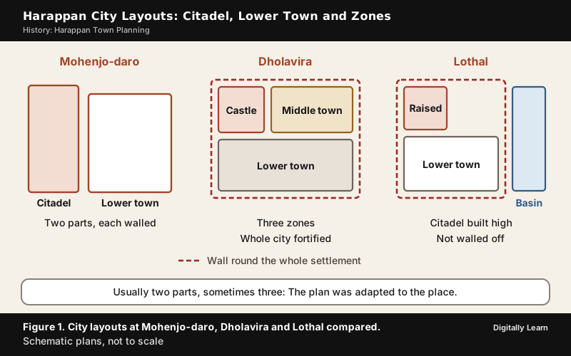
Most Harappan settlements have a small, high western part and a larger, lower eastern section. Archaeologists call the first the citadel and the second the lower town. At Mohenjo-daro the citadel stands on mud-brick platforms and was walled, which physically separated it from the lower town; the lower town was walled too. The citadel mound at Mohenjo-daro is around 12 metres high.
The citadel is where the structures with special public purposes stand, among them the Great Bath and the massive warehouse described below. The lower town holds the houses of the ordinary city, on streets and lanes. The same pattern is often described as an upper town, where the local elite probably lived, and a lower town, where common people lived. Whether the citadel housed rulers is an inference from the buildings, not something a text records, because the script is undeciphered.
The plan was not identical everywhere. At Dholavira and Lothal in Gujarat the entire settlement was fortified and sections inside were separated by walls. The citadel at Lothal was not walled off but was built at a height. Dholavira had three distinct zones rather than two.
Street Grid and Orientation
The roads and streets of the lower town were laid out along an approximate grid plan, intersecting at right angles. The word "approximate" matters: The grid is a clear tendency, not a surveyor's perfect lattice. Large cities had wide streets, often oriented to the cardinal directions, and smaller lanes ran off them, with individual houses of various sizes lining both.
At Kalibangan in Rajasthan a wide street has been uncovered in the lower town. At Dholavira the housing area of the middle town shows perpendicular streets, and the city's alignment in relation to the cardinal directions is among the features named in its World Heritage listing.
One consequence of laying out streets and drains first is that house plots were fixed by the street. If domestic waste water was to flow into the street drains, every house needed at least one wall along a street. That requirement links the grid, the drains and the house design into one system.
Dholavira, Kalibangan and Rakhigarhi: Plans Beyond the Indus Plains
The three Indian sites most often named in the syllabus show how the plan was adapted to place.
Dholavira, on Khadir island in the Rann of Kutch, was built with a fortified castle and an attached fortified bailey and ceremonial ground, a fortified middle town and a lower town, between two seasonal streams, the Mansar in the north and the Manhar in the south. Unlike Harappa and Mohenjo-daro, which were almost entirely of brick, its buildings, at least in their present state, were built of stone. UNESCO records stone masonry with mud-brick cores, and many stone structural remains survive.
Kalibangan, on the Ghaggar in Rajasthan, was excavated by the Archaeological Survey of India between 1960‑61 and 1969‑70; the full report on the Mature Harappan settlement was published in 2020. Its citadel is the smaller western mound. The site is also known for fire altars and for the earliest ploughed field revealed in an excavation, with furrows in a grid pattern, a reminder that the Harappans planned fields as well as streets.
Rakhigarhi in Haryana is one of the five largest Harappan settlements. The excavated parts show roads 1.92 metres wide, brick-lined drains and a granary of seven chambers. The Union Budget of 2020‑21 named Rakhigarhi and Dholavira among five archaeological sites to be developed as iconic sites with on-site museums.
Building Materials and Domestic Architecture
Standard Bricks and the 4:2:1 Ratio
Harappan builders used baked and unbaked brick in one fixed proportion. The length and breadth were four times and twice the height respectively, a ratio written 4:2:1. Such bricks were used at all Harappan settlements, and bricks of a uniform ratio are found throughout the region from Jammu to Gujarat, even though no single centre produced them all.
Three points sharpen this fact for the examination.
- Both kinds of brick: The standard applies to sun-dried and to baked brick, so "the Harappans used only baked brick" is wrong. Burnt brick was used where water had to be resisted: At Lothal, houses were of mud brick while the drains were of burnt brick.
- A ratio, not one size: What is standard is the proportion of length to breadth to height, which allows bricks of several actual sizes.
- Not every phase: At Kalibangan the bricks of the Early Harappan phase were of a markedly different size from those of the Mature Harappan phase, which is why the 4:2:1 brick is tied to the mature cities.
Dholavira is the exception: Its builders used stone for most structures where other cities used brick.
Houses of the Lower Town
Domestic architecture is best known from the lower town at Mohenjo-daro. Many houses were centred on a courtyard with rooms on all sides, which was probably the centre of cooking and weaving, especially in hot and dry weather. There were no windows in the ground-level walls along the street, and the main entrance did not give a direct view of the courtyard, an apparent concern for privacy.
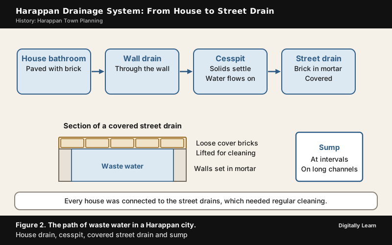
Every house had its own bathroom paved with bricks, connected by drains through the wall to the street drains. Some houses have remains of staircases to a second storey or the roof. Many had wells, often in a room reachable from outside and perhaps used by passers-by. Scholars estimate the total number of wells at Mohenjo-daro at about 700.
The quality of construction was the same for small and big houses, and all the buildings were generally of brick. Houses varied in size, but not in the quality of their building.
No palace or temple has been identified with certainty. A large building at Mohenjo-daro labelled a palace by archaeologists had no spectacular finds associated with it, and the "priest-king" is a label borrowed from Mesopotamia, not a proven office.
Drainage, Wells and Sanitation
Street Drains and House Connections
The drainage system was one of the most distinctive features of Harappan cities. Ernest Mackay called it "certainly the most complete ancient system as yet discovered". Its parts followed the path of the water.
House drains first emptied into a sump or cesspit, where solid matter settled while waste water flowed on into the street drains. The main channels were of bricks set in mortar and covered with loose bricks that could be removed for cleaning; in some cases limestone covers were used. Very long channels were provided at intervals with sumps for cleaning. Every house was connected to the street drains.
Mackay recorded little heaps of sand lying alongside the channels, which show that the debris was not always carted away when a drain was cleared. The system needed regular work, which implies someone organised that upkeep.
Drains were not confined to large cities. At Lothal, for example, houses were of mud bricks but drains were of burnt bricks. At Dholavira storm water was kept separate from domestic waste: An underground network of drains with gradients, capstones and manholes in the castle carried rain water to a reservoir, while household waste went to street-side jars, sanitary tanks and soakage pits in the middle and lower towns.
Wells and Water Supply Within the City
Water was drawn from wells in most Harappan cities. At Mohenjo-daro it came from hundreds of brick wells. The very tall wells seen at Mohenjo-daro appear to have been built up repeatedly as flooding and rebuilding raised the level of the streets.
In other regions water may have come from ponds, nearby streams or human-made reservoirs. Two Gujarat sites show two answers to the problem. Lothal had two wells, one in the citadel and one near the dock. Dholavira, in the arid Rann of Kutch, relied on reservoirs and channels rather than a single river, which is the subject of a later section.
The practical lesson is that a Harappan city's water system had three layers: Supply (wells, reservoirs), use (bathrooms, tanks) and removal (house drains, street drains, sumps). A good Mains answer names all three rather than "drainage" alone.
Public Buildings of the Citadel
The Great Bath of Mohenjo-daro
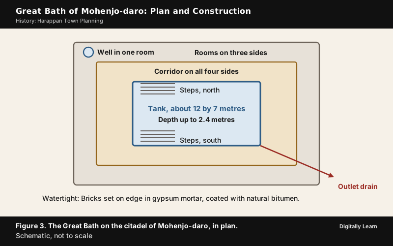
The citadel at Mohenjo-daro holds the structures built for special public purposes. The best known is the Great Bath, a large rectangular tank in a courtyard, with a corridor on all four sides. The tank measured about 12 by 7 metres, with a maximum depth of 2.4 metres.
Two flights of steps, one on the north and one on the south, led into the tank. It was made watertight by setting bricks on edge with a gypsum mortar, and natural bitumen, a form of tar, was applied over the carefully laid bricks. Rooms stood on three sides, and in one of them was a large well that may have supplied water. A drain at one corner emptied the tank so that it could be refilled with fresh water. A huge drain carried the water out of the tank.
A smaller building lay across a lane to the north, with eight bathrooms, four on each side of a corridor, and drains from each bathroom running to a drain along the corridor.
Archaeologists have suggested a public bath for people, a bath for the royal family only, or a tank for religious rituals. The first is ruled out because most houses had their own bathrooms. The uniqueness of the structure and its setting on the citadel, among distinctive buildings, lead scholars to suggest a special ritual bath. It is the best candidate, not a proven fact, because there is no inscription that explains it.
Granary or Warehouse: A Debate over Function
Large brick structures on the citadels of Mohenjo-daro and Harappa have long been called granaries. Mortimer Wheeler in 1950 identified a large building at Mohenjo-daro as a "Great Granary", pointing to wall divisions in its wooden superstructure that looked like grain-storage bays with air ducts. Jonathan Mark Kenoyer noted the complete lack of evidence for grain there and suggested "Great Hall" as a better name for a building of uncertain function.
The neutral word is "warehouse", a massive structure on the citadel whose lower brick portions remain and whose upper parts, probably of wood, decayed long ago. Large buildings of this kind seem to have been used for collective purposes, for instance as warehouses where goods to be transported were stored.
The debate matters for planning. A granary suggests a state collecting surplus grain. A warehouse suggests storage for goods in transit; a "Great Hall" suggests assembly. Each reading implies a different kind of authority.
A granary of the Mature Harappan phase at Rakhigarhi has seven rectangular or square chambers of mud brick, with lime and decayed grass on the lower wall; this evidence suggests grain storage with lime used against insects and grass against moisture.
Water Engineering at Dholavira and the Lothal Dock
Dholavira: Dams, Channels and Reservoirs
Dholavira stands on the arid island of Khadir in Kutch, a land where several years may pass without rain. Two seasonal streams provided its water, a scarce resource in the region, and the people built a system to catch, store and distribute it.
A seasonal stream was dammed at several points. Across the Manhar and Mansar, check dams of parallel walls and heavy cut-stone blocks slowed the flow. Plastered walls and raised inlet channels led the water along covered stone feeder channels into a chain of reservoirs, and city walls doubled as bunds. At least six large reservoirs were built of stone or cut into rock, and most were connected by underground drains for water harvesting and distribution. A drop of 13 metres in the ground from north-east to north-west let some of them use the slope.
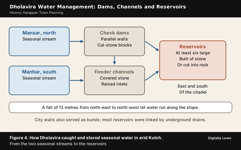
The reservoirs lay to the east and south of the citadel. NCERT gives the length of the largest reservoir as 73 metres, while other accounts give the reservoirs a length of about 79 metres. Some accounts also count sixteen or more reservoirs of varying size, so "at least six large reservoirs" is the safer figure for an answer.
UNESCO inscribed "Dholavira: A Harappan City" on the World Heritage List on 27 July 2021, as India's 40th World Heritage property. One of the criteria on which it was listed names preconceived city planning, multi-layered fortifications, sophisticated water reservoirs and drainage, and extensive use of stone. The site is protected by the Archaeological Survey of India.
The Lothal Dock: Evidence and Doubt
Lothal in Gujarat was discovered in 1954 and excavated from 13 February 1955 until 19 May 1960. The town was divided into blocks of platforms of sun-dried brick 1 to 2 metres high, and into an acropolis (citadel) and a lower town. In the acropolis were houses with paved bathing platforms and drains of kiln-fired bricks, a well and a warehouse with a ramp down to a basin.
The basin measures 217 metres in length and 36 metres in width, a little more than the length of two football grounds. The basin is read as a dockyard, a structure used to receive and send boats for the further transport of goods. Lothal may have had one of the world's earliest known docks, linked to an ancient course of the Sabarmati on a trade route.
The reading is contested. Some archaeologists argue that Lothal was a comparatively small town and that the "dock" was primarily an irrigation tank. Against that, the National Institute of Oceanography in Goa found marine microfossils (foraminifera) and salt and gypsum crystals in the rectangular structure, which indicate that sea water once filled it.
The safe wording is "a basin widely interpreted as a dockyard".
Weights and Measures: Standards for Trade and Construction
Chert Weights and the Binary-Decimal Scale
Planning needs a common measure. Exchanges in the Harappan cities were regulated by a precise system of weights. These were usually made of a stone called chert, were generally cubical and carried no markings. The lower denominations were binary (1, 2, 4, 8, 16, 32), while the higher followed the decimal system (160, 200, 320, 640). The smaller weights were probably used for weighing jewellery and beads, and metal scale-pans have also been found.
The uniformity of weights, seals, pottery and bricks across the region is the strongest evidence for central regulation. Bricks of a uniform ratio, though not produced in a single centre, were used from Jammu to Gujarat, which suggests that decisions were being taken and implemented over a wide area.
Who took these decisions is not settled. Some archaeologists think Harappan society had no rulers; others argue for several rulers, one for each city; others, pointing to the similarity of artefacts, the planned settlements and the standard brick ratio, argue for a single state. The planning evidence supports the claim that an authority existed, but it does not name one.
Harappan Sites Compared: Layout, Material and Water Works
Mohenjo-daro, Kalibangan, Lothal and Dholavira Compared
| Feature | Mohenjo-daro | Kalibangan | Lothal | Dholavira |
|---|---|---|---|---|
| Parts of the city | Walled citadel and walled lower town | Smaller western citadel mound and a lower town | Acropolis and lower town, whole settlement fortified | Three zones: Castle, middle town, lower town |
| Main material | Fired and mortared brick, some mud brick | Mud brick; early-phase bricks of a different size | Mud and burnt brick | Stone, with mud-brick cores |
| Water works and walls | About 700 wells, covered drains, Great Bath | Fortified with mud brick from the first occupation | Brick drains, two wells, dock basin | Dams, channels, at least six large reservoirs |
| Known for | Great Bath, "Great Granary" debate | Ploughed field, fire altars | Dockyard debate | Reservoirs, World Heritage 2021 |
The table shows that the idea of a planned city was shared while the means changed with the landscape: Brick in the Indus plain, stone in Kutch, and the basin at Lothal. What each site yielded beyond its plan is set out in Major Harappan Sites and Their Findings.
Harappan Planning and Present-Day Urbanisation
How Far Harappan Planning Informs Modern Urbanisation
Harappan planning offers present-day cities several precedents, and the comparison also has clear limits. The precedents are these:
- Zoning: The citadel and lower town divided public buildings from houses.
- Street and drain planning: Streets and drains were laid before houses, and every house was linked to the street drain.
- Sanitation: Every house at Mohenjo-daro had its own bathroom connected to the street drains, with covered, cleanable channels and sumps.
- Water harvesting: Dholavira caught seasonal rain in an arid region, the closest ancient parallel to today's rainwater harvesting.
- Standards: A uniform brick ratio and weights across the region were an early version of a building code.
- Equal quality of housing: Small and big houses were built to the same quality.
Where the comparison fails: Harappan cities were far smaller than a modern metropolis (an estimate puts the peak population of Mohenjo-daro at around 40,000, a weak estimate); no source records who governed them; and the continuity from Harappan practice to later Indian towns is a matter of interpretation. The inputs were ideas, not institutions.
A balanced conclusion is that the Harappans show that sanitation, drainage and water security were treated as part of the design of a city and not as afterthoughts, which is the lesson modern urbanisation most needs; the extent of any direct inheritance is limited.
Salient Features of Harappan Architecture
The salient features of Harappan architecture fall under six heads: Layout (citadel, lower town, grid, orientation); materials (standard brick, stone at Dholavira, mud-brick platforms); fortification (walls round citadel and lower town, or the whole settlement at Dholavira and Lothal); houses (courtyard, privacy, bathrooms, wells, staircases); public buildings (Great Bath, warehouse or granary, assembly or pillared halls); and water engineering (drains, reservoirs, dock basin). Add the limits: No palace or temple identified with certainty, and several functions debated.
Previous Year UPSC‑CSE Questions
Each question comes with an explanation of how to approach it.
- UPSC Prelims 2021Which one of the following ancient towns is well-known for its elaborate system of water harvesting and management by building a series of dams and channelizing water into connected reservoirs?
How to approach this Prelims question
Approach: The question asks for the town whose defining feature is a water-harvesting system of dams, channels and connected reservoirs. Match that feature to each site: Dholavira in arid Kutch dammed its two seasonal streams, led the water through feeder channels and stored it in a chain of reservoirs; Kalibangan is known for its fire altars and the earliest ploughed field revealed in an excavation; Rakhigarhi for its size, wide roads, brick-lined drains and a granary; Ropar is an excavated Harappan site in Punjab with no such system.
Trap to watch: Every option is a Harappan site, so the question turns on each site's own feature, not on whether it is Harappan.
Why each option is right or wrong:
- (a) Dholavira: Right. Its seasonal streams were dammed and the water led into at least six large reservoirs of stone or cut into rock.
- (b) Kalibangan: Wrong. It is known for fire altars and the earliest excavated ploughed field, not for reservoirs.
- (c) Rakhigarhi: Wrong. It is one of the five largest Harappan settlements, known for roads 1.92 metres wide, drains and a granary.
- (d) Ropar: Wrong. It is an excavated Harappan site in Punjab, not the town of dams and connected reservoirs.
Answer: (a) Dholavira. Dholavira's dams, channels and connected reservoirs, recognised by UNESCO in 2021.
- UPSC Mains 2014 GS‑ITo what extent has the urban planning and culture of the Indus Valley Civilization provided inputs to the present day urbanization? Discuss.
Answer outline
The outline sets out what the question asks, the main arguments, relevant examples and the direction of the conclusion; it is not a full model answer.
Introduction: Harappan cities were laid out to a plan: A citadel and a lower town, an approximate grid and a standard brick.
Body (sub-themes to develop):
- Zoning and layout: The citadel and lower town; streets and drains laid out before houses.
- Sanitation and water: Every house linked to covered street drains with sumps; wells; Dholavira's dams and reservoirs.
- Standards: The uniform brick ratio from Jammu to Gujarat and standard weights, an early building code.
- Culture: Houses built to the same quality, and a courtyard plan that kept privacy.
- Limits: A far smaller scale, no record of who governed, and continuity that is a matter of interpretation.
Conclusion: The lasting input is an idea: Drainage, water and layout designed together; direct inheritance is limited.
- UPSC Mains 2025 GS‑IDiscuss the salient features of the Harappan architecture.
Answer outline
Introduction: Harappan architecture belongs to the Mature Harappan phase, 2600 BCE to 1900 BCE, and followed one plan across a wide area.
Body (sub-themes to develop):
- Layout: Citadel and lower town, an approximate grid oriented to the cardinal directions; three zones at Dholavira.
- Materials: The 4:2:1 brick, baked and sun-dried; stone at Dholavira; mud-brick platforms.
- Fortification: Walls round the citadel and the lower town, or round the whole settlement at Dholavira and Lothal.
- Houses: Courtyards, no ground-level windows on the street, brick-paved bathrooms, wells and staircases.
- Public buildings and water works: The Great Bath, the warehouse or granary, covered drains, reservoirs and the Lothal basin.
Conclusion: The architecture was practical and uniform; no palace or temple is identified with certainty, and several functions remain debated.
Sources
- NCERT Class XII, Themes in Indian History I: Bricks, Beads and Bones
- NCERT Class VI, Exploring Society, India and Beyond: The Beginnings of Indian Civilisation
- NCERT Class XI, An Introduction to Indian Art: Arts of the Indus Valley
- UNESCO World Heritage Centre: Dholavira, a Harappan City
- Press Information Bureau: India gets its 40th World Heritage Site, Dholavira
- Union Budget 2020‑21: Budget speech
- Archaeological Survey of India: Excavations at Kalibangan, Part II
- Wikipedia: Dholavira
- Wikipedia: Great Bath of Mohenjo-daro
- Wikipedia: Sanitation of the Indus Valley Civilisation
- Wikipedia: Mohenjo-daro
- Wikipedia: Harappa
- Wikipedia: Lothal
- Wikipedia: Kalibangan
- Wikipedia: Rakhigarhi
- Wikipedia: Indus Valley Civilisation
- UPSC: Civil Services Examination question papers
Editorial Disclaimer
This article draws on the current NCERT textbooks, the UNESCO World Heritage listing of Dholavira, the Press Information Bureau and the other sources listed in the Sources section.