


Overview
Isostasy is the state of balance in which the earth's crust floats on the denser mantle beneath it, standing high where it is thick or light and low where it is thin or dense. The word comes from the Greek for equal standstill. The theory of isostasy explains why continents and mountains stand above the ocean floors, why mountains have deep roots, and why the land rises or sinks when a load of ice, rock or sediment is added or removed. The two classical models, by George Airy and John Henry Pratt, date from 1855.
What Is Isostasy? Meaning and Concept of Isostasy in Geography
Isostasy Meaning and Definition
Isostasy, from the Greek isos, equal, and stasis, standstill, is the state of gravitational equilibrium between the earth's crust, or lithosphere, and the mantle. The crust floats at an elevation that depends on its thickness and its density. That is why different heights can exist side by side on the earth's surface: high mountains, broad plateaus, low plains and deep ocean floors.
The general term was coined in 1882 by the American geologist Clarence Dutton, who used it in 1889 for the general phenomenon. The idea began with continental crust floating on the mantle and was later restated as the lithosphere floating on the asthenosphere. Isostasy describes an ideal, static balance; the real earth is always moving, and some regions, such as the Himalaya and other convergent margins, are not in isostatic equilibrium at all.
Concept of Isostasy: Lithosphere Floating on the Asthenosphere
The concept of isostasy rests on the structure of the earth's interior. The crust is the outermost solid, brittle layer; beneath it lies the mantle, and the upper portion of the mantle is the asthenosphere, from a Greek word meaning weak. The crust together with the uppermost part of the mantle forms the lithosphere, 10 to 200 km thick, which rests on the weak, ductile asthenosphere.
- Oceanic crust: Mean thickness about 5 km; the Moho, its base, lies 5 to 10 km below the ocean floor.
- Continental crust: Mean thickness about 30 km; the Moho lies 20 to 90 km down, 35 km on average.
- Under mountains: The continental crust is thicker, as much as 70 km in the Himalayan region.
- Densities: Crust about 2,750 kg per cubic metre, mantle about 3,300 kg per cubic metre.
The lighter crust floats on the denser mantle much as an iceberg floats in water, with most of its mass below the surface. Snow piled on top makes an iceberg sink lower; ice melting off its top lets it rise. The lithosphere behaves in the same way on the asthenosphere, which over geological time behaves like a fluid.
Isostasy Theory of Airy and Pratt: The Models of 1855
Discovery of Isostasy: Plumb Lines in the Andes and the Himalaya
Isostasy was discovered by surveyors who noticed that mountains pull less than they should. French geodesists measuring the shape of the earth in Ecuador expected the nearby Andes to deflect their plumb lines. The deflection was smaller than expected, which suggested that the mountains had low-density roots compensating for their mass.
British surveyors found the same thing in India. The Great Trigonometrical Survey had to correct for the gravitational pull of mountains on its plumb lines. Andrew Scott Waugh, the Surveyor General who succeeded George Everest, asked John Henry Pratt to examine the effect of the Himalaya. Pratt calculated the deflection the mountains should cause, but the observed deflections were much less.
Later gravity surveys generalised the finding. The Bouguer anomaly, the difference between the measured gravity and that expected for the height and terrain, is positive over ocean basins and negative over high continental areas. So the low ocean basins and the high continents are both balanced at depth, and in 1855 two hypotheses were put forward to explain how.
Airy Theory of Isostasy: Mountains with Deep Roots
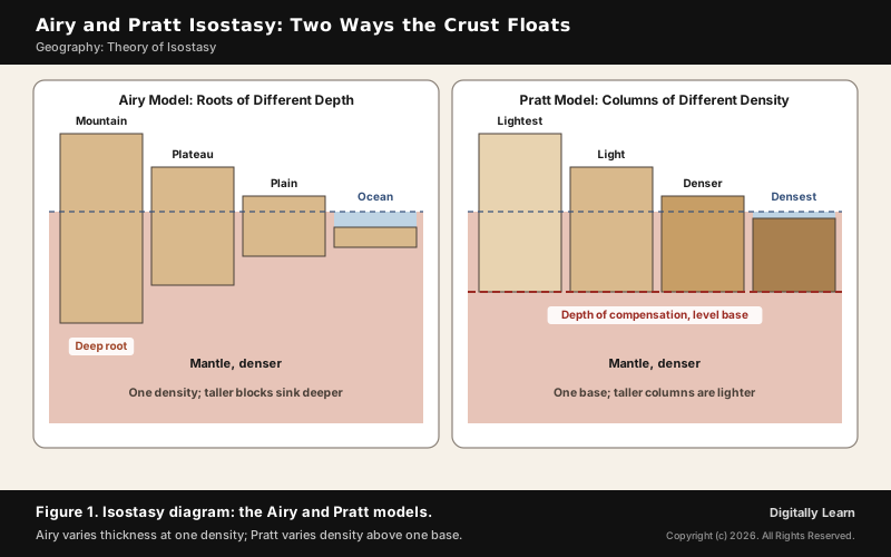
In the Airy model, the crust has one density everywhere, and different heights are balanced by differences in crustal thickness. A high mountain is like a thick block of wood floating in water: it rises high above the surface and sinks a deep root below. A plain is a thinner block, and the ocean floor is thinner still. The isostasy diagram in Figure 1 sets the two models side by side.
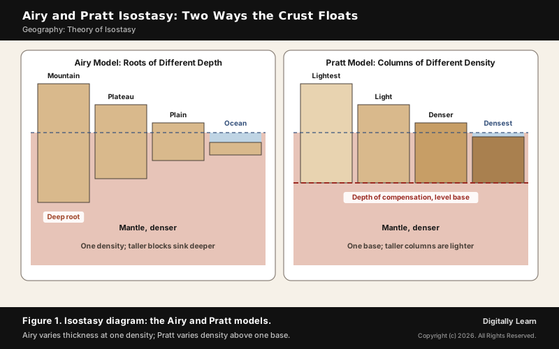
The model rests on Pascal's law: in a fluid at rest, the pressure is the same at every point at the same depth. With a crust of about 2,750 and a mantle of about 3,300 kg per cubic metre, the root of a mountain works out to about five times its height. Under the oceans the balance runs the other way: the crust is thinner, so the mantle rises closer to the surface, by about 3.2 times the depth of the water.
Pratt Theory of Isostasy and the Difference from Airy
In the Pratt model, different heights are balanced by lateral changes in rock density. All columns of crust end at the same level, the depth of compensation. A tall column is made of lighter rock and a low one of denser rock, so every column presses equally on the level beneath. Pratt proposed that the density of the mountains was less than that of the substrate beneath them.
The Pratt idea fits some features better. Mid-ocean ridges stand high because the upper mantle beneath them is unusually light, expanded by heat. In the Basin and Range Province of western North America, the base of the crust does not follow the height of the land, which points to lateral density differences in the upper mantle. How ridges form is covered in mid-ocean ridges.
Airy and Pratt isostasy share two ideas: both float the crust on the denser mantle, and both assume a local, hydrostatic balance. They differ in what varies from place to place.
| Point | Airy model | Pratt model |
|---|---|---|
| Density of crust | Same everywhere | Varies from column to column |
| Thickness of crust | Varies with height | Same base for all columns |
| Base of the crust | Uneven; deep roots under mountains | Level, at the depth of compensation |
| Mountains are | Thick crust with deep roots | Columns of lighter rock |
| Best explains | Thick crust and roots under ranges | Mid-ocean ridges, lateral density changes |
| Later refined by | Heiskanen | Hayford |
Heiskanen, Vening Meinesz and the Depth of Compensation
Heiskanen Theory of Isostasy and the Pratt-Hayford Model
The two classical models were refined in the twentieth century. The Finnish geodesist Veikko Aleksanteri Heiskanen (1895 to 1971) refined Airy's hypothesis, drawing on the theories of both Airy and Pratt, into his own Heiskanen hypothesis. The refined model is known as the Airy-Heiskanen model: different heights are accommodated by changes in crustal thickness, with the crust at one density.
Heiskanen directed the International Isostatic Institute from 1936, and in 1958 he wrote a textbook, The Earth and its Gravity Field, with the Dutch geodesist Vening Meinesz. The Pratt hypothesis was refined in the same way by the American geodesist John Fillmore Hayford, whose work combined isostasy with the measurement of the shape of the earth.
- Airy-Heiskanen model: Heights balanced by changes in crustal thickness; one crustal density.
- Pratt-Hayford model: Heights balanced by lateral changes in rock density above a level base.
- Both: Assume a local hydrostatic balance, with each column balanced on its own.
Vening Meinesz Model: Flexural or Regional Isostasy
The third model treats the lithosphere as a rigid, elastic plate rather than a set of separate blocks. A heavy load does not sink straight down on its own; the plate bends under it, and its rigidity spreads the load over a broad region. This is flexural or regional isostasy, the Vening Meinesz model.
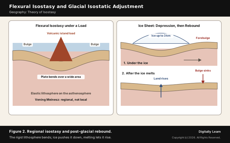
The idea explains how large loads such as the volcanic Hawaiian Islands are supported by a wide area of bent lithosphere rather than by a root directly beneath. It was first invoked in the late nineteenth century for the uplifted shorelines of Scandinavia after the ice sheets melted, and G. K. Gilbert used it for the raised shorelines of Lake Bonneville. It was developed in the 1950s by Felix Vening Meinesz, who between 1923 and 1929 measured gravity at sea from small submarines.
Depth of Compensation and the Isostatic Anomaly
The depth of compensation, also called the level of compensation, is the depth below which the pressure is the same across any horizontal surface. In stable regions it lies in the deep crust; in active regions it may lie below the base of the lithosphere. In the Pratt model it is the depth below which all rock has the same density.
The isostatic anomaly measures how far a region departs from balance. It is the Bouguer anomaly minus the part explained by compensation at depth. Perfect equilibrium would need a mantle at rest, but the mantle convects, so real regions depart from the ideal. The largest isostatic anomalies on earth lie over convergent plate margins, where active forces hold the surface up.
Isostatic Adjustment in Geography: How the Crust Rises and Sinks
Isostatic Adjustment: Erosion, Deposition and Mountain Roots
Isostatic adjustment in geography is the return of the crust towards balance after its load changes. When large amounts of sediment are deposited on a region, their weight makes the crust below sink. When large amounts of rock are eroded away, the land rises to compensate.
This makes mountain building and mountain wearing a long exchange. Crustal thickening in a collision raises mountains through isostasy. As the range is eroded, the lighter range rebounds upward and is eroded further, so rocks that once lay deep inside a mountain are slowly brought to the surface. Erosion and isostatic adjustment together can expose the metamorphic core, the roots, of an old range.
- Load added: Sediment, ice, water or lava; the crust sinks and mantle material flows away.
- Load removed: Erosion or melting ice; the crust rises as mantle material flows back.
- Speed: Slow; isostatic depression and rebound occur at rates of centimetres a year, and the uplift from the end of the last glacial period is still continuing.
Post-Glacial Rebound: Scandinavia, Hudson Bay and Raised Beaches
The clearest example is post-glacial rebound, the rise of land after the melting of the ice sheets of the last glacial period. At the Last Glacial Maximum, some 20,000 years before the present, ice up to three kilometres thick covered much of northern Europe, Asia, North America, Greenland and Antarctica. Its weight warped the crust downward and forced mantle material to flow away.
When the ice melted, the land began to rise in two stages: an almost immediate elastic response, then slow viscous flow. Today typical uplift rates are about 1 cm a year or less, with a peak of about 11 mm a year in the north of the Gulf of Bothnia, and rebound should continue for at least another 10,000 years.
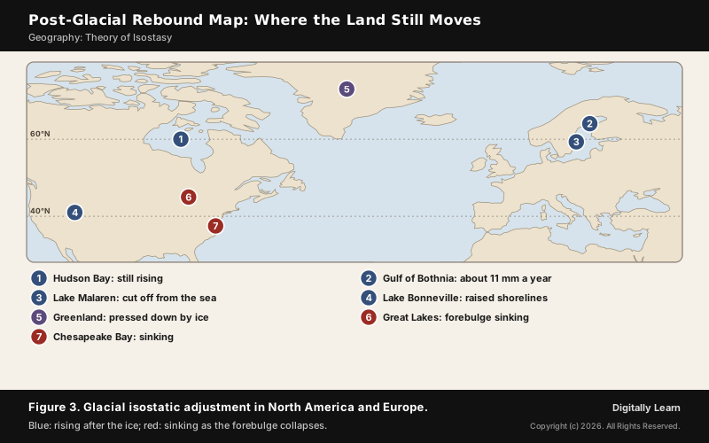
- Sweden: Lake Malaren was an arm of the Baltic Sea until uplift cut it off, making it a freshwater lake in about the twelfth century.
- Kvarken: A UNESCO World Natural Heritage Site chosen as the type area for post-glacial rebound; the Gulf of Bothnia is expected to close there in more than 2,000 years.
- Hudson Bay: Its gravity anomaly matches the area of the former Laurentide ice sheet, a sign of adjustment still under way.
- Raised beaches: Former sea cliffs and wave-cut platforms now stand hundreds of metres above sea level.
Isostatic Depression, Forebulge Collapse and Eustatic Change
Isostatic depression is the sinking of the crust under a heavy load, most often glacial ice; Greenland is still pressed down by its ice sheet today. Beyond the edge of an ice sheet, the displaced mantle pushes the land up into a forebulge, much as a mattress bulges around a person lying on it.
When the ice goes, the centre rises and the forebulge sinks. The east coast of the United States and the Great Lakes lay on the forebulge of the North American ice and are still sinking; the land around Chesapeake Bay may sink by as much as half a foot over the next 100 years. That is why post-glacial rebound is now called glacial isostatic adjustment: the land moves down and sideways as well as up.
| Point | Isostatic change | Eustatic change |
|---|---|---|
| What moves | The land | The level of the sea itself |
| Scale | Regional | Global |
| Causes | Loading or unloading by ice, rock, sediment | Change in ocean water mass or volume, ridge spreading |
Isostasy in the Himalaya and the Indo-Gangetic Plain
Himalayan Isostasy and the Indo-Gangetic Trough
The Himalaya rose after the Indian plate collided with the Eurasian plate. The uppermost Indian crust was folded and thrust into nappes, while a lower layer pushed on into Tibet and thickened its plateau. The crust under the Himalayan region is as much as 70 km thick, against about 30 km for continental crust in general.
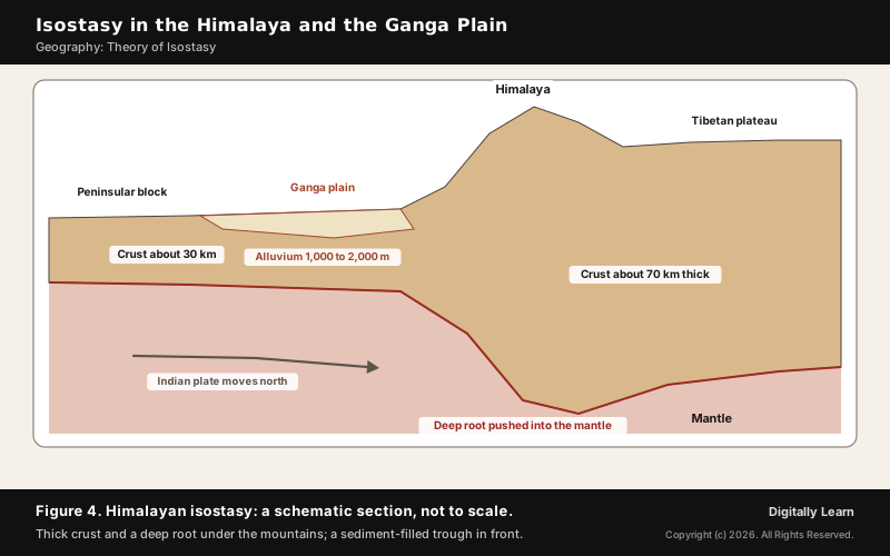
In a collision zone the crust can thicken to 80 km, against about 40 km for average continental crust. The Airy model predicts roots about five times deeper than the mountains are high, so most of the thickened crust moves down rather than up. Yet the Himalaya are not in full isostatic balance: convergent margins are highly active, their surface is partly held up by horizontal forces, and they show the highest isostatic anomalies on earth.
South of the mountains lies the plain of the Indus, the Ganga and the Brahmaputra. It was originally a geosynclinal depression that reached its maximum development during the third phase of Himalayan mountain building, about 64 million years ago. A trough formed in front of the rising Himalaya, and since then it has been filled by sediment brought down by Himalayan and Peninsular rivers.
- Depth of fill: The average depth of alluvial deposits in these plains is 1,000 to 2,000 m.
- Basement: Beneath the silt lie hard crystalline rocks that connect the Himalayan region with the Peninsula.
- Extent: The plains form the world’s largest expanse of uninterrupted alluvium.
- Isostatic link: The immense weight of new sediment makes the crust below sink, so a basin that keeps receiving sediment keeps making room for more.
The Ganga plain and its rivers are covered in Ganga geomorphology.
Himalaya as Young Fold Mountains: Evidence in the Landscape
The Himalaya are geologically young and structurally fold mountains. Unlike the rigid, stable Peninsular block, they are still subject to the interplay of endogenic and exogenic forces, which produces faults, folds and thrust planes. Their youth shows in the landscape.
- Deep gorges: Fast-flowing rivers in their youthful stage cut gorges, V-shaped valleys, rapids and waterfalls.
- U-turn river courses: The Yarlung Tsangpo, the upper Brahmaputra, bends round Namcha Barwa in a great bend, and the Indus makes its northernmost bend near Nanga Parbat.
- Parallel ranges: The Himalaya consist of three parallel ranges, the Great or Inner Himalaya (Himadri), the Himachal or Lesser Himalaya, and the Shiwaliks.
- Landslides: The highly unstable, relatively young Himalayan mountains fall in the very high landslide vulnerability zone.
Fold Mountains, Plate Margins and Isostasy
Why Fold Mountains Lie Along the Margins of Continents
Fold mountains form where plates move towards each other, at a convergent plate boundary. When plates and the continents riding on them collide or one rides over the other, layers of rock crumple and fold like a tablecloth pushed across a table. This mountain building, orogeny, happens where plate motion compresses a continental margin, which is why young fold ranges line the edges of continents.
- Oceanic and continental plate: The oceanic plate dives under the continent, and the continental margin is folded and raised.
- Two continental plates: Continental lithosphere is too light to sink far, so the crust between them is crushed and thickened, as in the Himalaya.
- Two oceanic plates: One dives under the other at a subduction zone.
Isostasy completes the picture. Because the lighter continental crust floats on the denser mantle, the weight of rock forced up into mountains must be balanced by a much greater volume forced down into the mantle. So the continental crust is much thicker under mountains than under low-lying areas, and ranges are long and narrow belts along the margins where the squeezing happens. Plate movement is covered in plate tectonics.
Fold Mountains, Earthquakes and Volcanoes: One Global Pattern
Maps of fold mountains, earthquakes and volcanoes show the same pattern, because all three mark plate margins. Earthquakes concentrate along the mid-oceanic ridges, the Alpine-Himalayan system and the rim of the Pacific. Along the ridges their foci are shallow; along the Alpine-Himalayan belt and the rim of the Pacific they are deep-seated.
- Rim of fire: The map of volcanoes shows a similar pattern, and the rim of the Pacific is called the rim of fire for its active volcanoes.
- Alpine-Himalayan belt: Fold mountains and deep earthquakes where continents converge.
- Isostatic earthquakes: Isostatic adjustment itself can cause earthquakes, as the crust rebounds after ice sheets melt.
Previous Year UPSC-CSE Questions
Previous Year UPSC-CSE Questions By the end you will be able to draft model answers for the following UPSC questions. Each question carries a collapsible framework showing how to approach it in the exam.
- UPSC Mains 2014 GS-IWhy are the world’s fold mountain systems located along the margins of continents? Bring out the association between the global distribution of fold mountains and the earthquakes and volcanoes.
How to structure the answer in the exam
Introduction: Define fold mountains as ranges formed by the folding of crustal rocks where plates converge.
Body (sub-themes to develop):
- Convergent boundaries lie along continental margins; compression there folds the rock layers.
- Three kinds of convergence: ocean-continent, continent-continent, ocean-ocean.
- Isostasy: rock forced up is balanced by a deep root, so ranges stand on thick crust.
- Earthquake belts: mid-oceanic ridges (shallow) and the Alpine-Himalayan belt and Pacific rim (deep).
- Volcanoes follow the same pattern; the rim of the Pacific is the rim of fire.
Conclusion: Conclude that fold mountains, earthquakes and volcanoes are three expressions of the same plate margins.
- UPSC Prelims 2012 Prelims-GSWhen you travel in Himalayas, you will see the following :
- Deep gorges
- U-turn river courses
- Parallel mountain ranges
- Steep gradients causing landsliding
Which of the above can be said to be the evidences for Himalayas being young fold mountains?
How to approach this Prelims question
Approach: Ask of each feature whether it shows active uplift and youthful erosion.
Trap to watch: U-turn courses and landslides can look unrelated, but both reflect young, still-rising mountains.
Key facts to recall:
- Youthful rivers cut gorges and V-shaped valleys
- The Himalaya lie in the very high landslide vulnerability zone
Answer signal: All four, option (d).
Sources
- NCERT: Fundamentals of Physical Geography (Class XI), Interior of the Earth
- NCERT: Fundamentals of Physical Geography (Class XI), Distribution of Oceans and Continents
- NCERT: India Physical Environment (Class XI), Structure and Physiography
- NCERT: India Physical Environment (Class XI), Natural Hazards and Disasters
- NCERT: Contemporary India I (Class IX), Physical Features of India
- NOAA National Ocean Service: What is glacial isostatic adjustment?
- USGS: This Dynamic Earth, Inside the Earth
- NASA JPL GRACE Tellus: Antarctic ice loss 2002 to 2020
- Wikipedia: Isostasy
- Wikipedia: Post-glacial rebound
- Wikipedia: Flexural isostasy
- Wikipedia: Isostatic depression
- Wikipedia: Gravity anomaly
- Wikipedia: John Henry Pratt
- Wikipedia: Weikko Aleksanteri Heiskanen
- Wikipedia: John Fillmore Hayford
- Wikipedia: Vening Meinesz
- Wikipedia: Clarence Dutton
- Wikipedia: Great Trigonometrical Survey
- Wikipedia: Asthenosphere
- Wikipedia: Mohorovičić discontinuity
- Wikipedia: Fold mountains
- Wikipedia: Orogeny
- Wikipedia: Himalayas
- Wikipedia: Indo-Gangetic Plain
- Wikipedia: Yarlung Tsangpo Grand Canyon
- Wikipedia: Eustatic sea level
- Wikipedia: Hudson Bay
- UPSC: Civil Services Examination question papers
Editorial Disclaimer
This article draws on the NCERT geography textbooks, NOAA, USGS and the other sources listed on this page. Diagrams are schematic and not drawn to scale.


