


Overview

Corrasion, also called abrasion, is erosion by the load a river, wave, glacier or wind carries: the sand and pebbles grind against the rock like sandpaper. It is one of four processes of erosion. Hydraulic action, corrasion and attrition are mechanical; corrosion, or solution, is chemical, dissolving soluble rock such as limestone.
Erosion: Meaning, Agents and the Four Processes
What Is Erosion? Meaning, Agents and the Four Processes
Erosion involves the acquisition and transportation of rock debris. Once rock has been broken into fragments, the geomorphic agents, running water, groundwater, glaciers, wind and waves, remove it and carry it elsewhere, and by erosion the relief is worn down.
- Energy of erosion: Erosion is the application of the kinetic energy of the agent to the land it moves over; kinetic energy is half the mass times the square of the velocity.
- Most effective: Glaciers move slowly but, because of their great mass, erode more than any other agent.
- Least effective: Wind, being a gas, erodes least.
- Climate-controlled agents: Wind, running water and glaciers; the work of waves depends on the coast and that of groundwater on the rock.
Erosion and weathering are linked but different. Weathering breaks rock down where it lies; erosion removes it. Weathering aids erosion but is not a precondition for it, and weathering, mass wasting and erosion together are the degradational processes that wear the land down.
Whatever the agent, it attacks rock in four ways. Removal of rock as clastic sediment is mechanical erosion; removal by dissolution is chemical erosion. Three processes are mechanical and one is chemical.
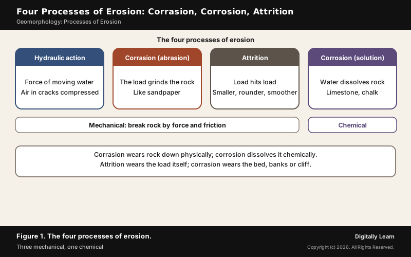
| Process | Type | How it works |
|---|---|---|
| Hydraulic action | Mechanical | Moving water dislodges rock; waves compress air in cracks |
| Corrasion (abrasion) | Mechanical | The carried load grinds the bed, banks or cliff |
| Attrition | Mechanical | Pieces of the load collide and wear each other down |
| Corrosion (solution) | Chemical | Water dissolves soluble rock such as limestone and chalk |
Hydraulic Action, Corrasion, Attrition and Corrosion Explained
Hydraulic Action: Meaning and How It Works
What is hydraulic action? It is the ability of moving water, a current or a wave, to dislodge and carry away rock particles. It is a mechanical process: a river's current flows against its bed and banks and removes particles, adding them to the stream's load.
On coasts it works with air. A wave striking a cliff compresses the air in cracks, which presses on the surrounding rock; when the wave retreats, the air decompresses suddenly with explosive force. Each cycle widens the cracks, so every wave traps more air, and over time the cracks may grow into a sea cave. In coastal areas hydraulic action is often the most important form of erosion.
Corrasion Meaning: Abrasion by the Load
Corrasion and abrasion are two names for one process: corrasion is erosion by the material an agent carries. Sand, pebbles and boulders are dragged or thrown against the rock, wearing it away much as sandpaper does. The intensity depends on the hardness, concentration, velocity and mass of the moving particles.
- Glaciers: Ice grinds the rocks it has picked up against the bedrock.
- Corrasion in rivers: Objects carried in the channel scrape the bed and walls.
- Waves: Rock debris is thrown against the cliff face.
- Wind: Sand and small stones are driven against rock surfaces.
Waves hurling their load at a cliff make corrasion a highly effective and rapid form of shoreline erosion. On land it cuts potholes: over rocky hill-stream beds, circular depressions form through stream erosion aided by the abrasion of rock fragments, and pebbles caught in them are rotated by the water until the holes deepen and join.
Attrition and the Difference Between Attrition and Abrasion
Erosion of the load itself is attrition. As rock fragments are carried by water or wind, they collide, chipping and grinding each other until they become smaller, smoother and rounder, and over time attrition turns boulders into smaller rocks and eventually into sand.
| Point | Attrition | Abrasion (corrasion) |
|---|---|---|
| What wears | The carried particles themselves | The bed, banks, cliff or bedrock |
| How | Particles hit each other | Particles rub against a surface |
| Result | Smaller, rounder, smoother load | A worn, scratched or hollowed surface |
The two are often confused. Abrasion comes from two surfaces rubbing, wearing one or both down; attrition comes from objects hitting each other and breaking off particles. The rounded pebbles on a beach or river bed are the work of attrition, and researchers read particle shapes to study past erosion.
Corrosion in Geography: Solution, Carbonation and Karst
In geography, corrosion, also called solution, is chemical erosion: water dissolves rock rather than wearing it by force. It works best on soluble rock such as limestone and chalk, and on coasts it occurs when sea water is slightly acidic.
The chemistry is carbonation. Carbon dioxide from the air and soil air dissolves in water to form carbonic acid, a weak acid, and calcium and magnesium carbonates dissolve in it and are carried away in solution. Rain therefore weathers rock, and hydration, carbonation and oxidation go hand in hand.
Groundwater erodes almost entirely by corrosion. Physical removal by moving groundwater is insignificant, so its landforms appear only in soluble rock such as limestone and dolomite, where solution and precipitation shape the land. Such a region is called karst, after the Karst region of the Balkans next to the Adriatic Sea.
- Swallow holes: Small round depressions formed on limestone by solution.
- Sinkholes: Funnel-shaped openings from a few square metres to a hectare, some formed solely by solution.
- Caves: Hollowed out by solution underground, later decorated by stalactites and stalagmites.
Caves form where water percolates through cracks and joints and moves along bedding planes, dissolving the limestone into long, narrow to wide gaps. On the surface, solution along parallel joints leaves a field of lapies, which may eventually turn into smooth limestone pavements.
Processes of Erosion by Rivers, Groundwater, Glaciers, Waves and Wind
Processes of Erosion in a River: Down-Cutting, Lateral and Headward
Running water erodes in two forms, overland flow as a sheet and linear flow in streams. Sheet erosion concentrates into rills, rills grow into gullies, and gullies deepen, widen and join into valleys. Soil erosion follows four stages in order of severity: splash, sheet, rill and gully.
Soil erosion is the accelerated removal of topsoil through water, wind and tillage. It happens naturally, but intensive agriculture, deforestation, overgrazing and poor land use can speed it up as much as 1,000 times, and it can cut crop yields by up to 50 per cent.
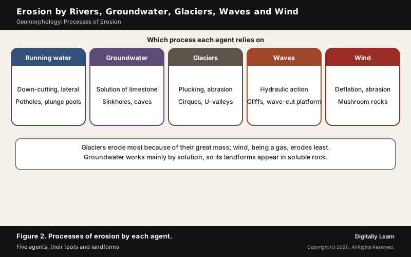
- Vertical (down-cutting): Dominant early on, giving V-shaped valleys, gorges and canyons.
- Lateral: As the bed gentles, the river erodes its banks, widening the valley and meandering.
- Headward: The valley extends back into the hillside.
- Plunge pools: At the foot of waterfalls, the impact of water and rotating boulders cuts deep holes.
Valley shape depends on the rock. A gorge is a deep valley with very steep, straight sides, almost as wide at the top as at the bottom, and forms in hard rock; a canyon has steep step-like sides, is wider at the top, and forms commonly in horizontally bedded sedimentary rock. Waterfalls too are transitory and recede gradually.
Most stream erosion happens during floods, when more and faster water carries a larger load. Over a very long time erosion can reduce a landscape to a peneplain, a lowland of faint relief with low resistant remnants called monadnocks.
Glacial Erosion: Plucking and Abrasion
Erosion by glaciers is tremendous because of the friction of the sheer weight of ice. Glaciers erode in two ways. In plucking, also called quarrying, the ice pulls away blocks of bedrock, exploiting existing fractures; in abrasion, the angular blocks dragged along the valley floor and sides scrape the rock.
The result is a distinct set of landforms. Cirques, the most common landform in glaciated mountains, are deep basins with steep walls at the heads of glacial valleys, and glaciated valleys are trough-like and U-shaped with broad floors. Glaciers can wear even unweathered rock and reduce high mountains to low hills and plains.
- Horns: Where three or more glaciers cut headward until their cirques meet, sharp peaks form; the Matterhorn and Everest are horns.
- Aretes: Divides between cirques narrow into saw-toothed ridges.
- Hanging valleys: Side valleys left at a height above the main glacial valley.
- Fjords: Very deep glacial troughs filled with sea water, in high latitudes.
Wave Erosion and Processes of Wind Erosion
On high rocky coasts, waves break with great force and shape the land into cliffs. Pounding makes the cliffs recede, leaving a wave-cut platform in front; waves and the debris they hurl hollow out sea caves, cave roofs collapse, and isolated remnants are left as sea stacks.
Wind erodes by three processes. Deflation lifts and removes dust and small particles, abrasion uses sand and silt as tools, and impact is the sheer force of sand blown against rock, much like sand-blasting. Deflation leaves hollows; together, deflation and abrasion wear outcrops into mushroom rocks with slender stalks and broad caps.
Rock faces struck by wind-borne sand first develop shallow depressions called blow outs, and some grow deep and wide enough to be called caves. Where the top of a worn outcrop is broad, it is a table rock; other remnants stand out as pedestal rocks.
Coastal Erosion in India: Extent, Causes and Management
Coastal Erosion in India: Extent and Causes
The National Centre for Coastal Research, a Chennai body of the Ministry of Earth Sciences and formerly the ICMAM Project Directorate, monitored India's shoreline for 1990 to 2018 using satellite images and field surveys. Of the 6,907 km of mainland coast studied, about 33.6 per cent was eroding, 26.9 per cent was growing by accretion and 39.6 per cent was stable.
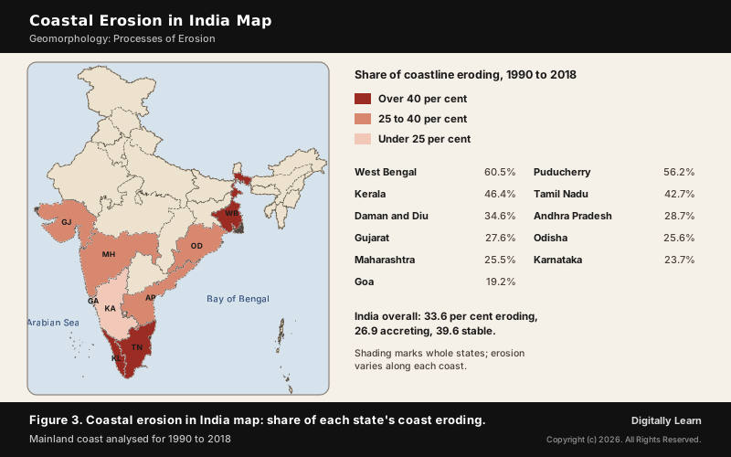
- Worst affected: West Bengal (60.5 per cent of its coast eroding), Puducherry (56.2), Kerala (46.4) and Tamil Nadu (42.7).
- Natural causes: More frequent cyclones and rising sea level.
- Human causes: Construction of harbours, beach mining and the building of dams.
- Effects of coastal erosion: Loss of land and habitat, and loss of space for fishermen to park boats, mend nets and fish.
Erosion also continues after the study period. An updated NCCR study found about 58 per cent of the Valsad coast and 60 per cent of the Navsari coast in Gujarat eroding over 1990 to 2022.
Coastal Erosion Management: Hard, Soft and Nature-Based Methods
Coastal erosion is managed in three broad ways: hard-erosion controls, soft-erosion controls and relocation. Hard controls such as seawalls and groynes last longer, a seawall for 50 to 100 years and a groyne for 30 to 40, but they can block access to the beach and alter it drastically.
- Soft and temporary: Beach nourishment and sandbags, not meant as permanent solutions.
- Nature-based: Mangrove forests and coral reefs, a natural form of protection.
- Indian pilots: A submerged reef with beach nourishment restored 1.5 km of Puducherry’s city beach after 30 years; an offshore submerged dyke protected three fishing villages at Kadalur Periya Kuppam, Tamil Nadu.
- Regulation: A hazard line for the whole coast, the Coastal Regulation Zone Notification 2019 with No Development Zones, and Shoreline Management Plans.
- Funding: Guidelines of 20 June 2024 fund coastal and river erosion work under the National Disaster Management Fund, with Rs 1,500 crore recommended for 2021-26.
Previous Year UPSC-CSE Questions
Previous Year UPSC-CSE Questions By the end you will be able to draft model answers for the following UPSC questions. Each question carries a collapsible framework showing how to approach it in the exam.
- UPSC Mains 2022 GS-IIIExplain the causes and effects of coastal erosion in India. What are the available coastal management techniques for combating the hazard?
Answer outline: how to structure the answer
What the question asks, the main arguments, relevant examples and the direction of the conclusion. This is not a full model answer.
Introduction: About a third of India's mainland coast, 33.6 per cent, was eroding over 1990 to 2018 (NCCR).
Body (sub-themes to develop):
- Causes: cyclones and sea-level rise; harbours, beach mining and dams.
- Effects: loss of land, habitat and fishermen's working space; West Bengal and Puducherry worst hit.
- Hard methods: seawalls and groynes, long-lasting but damaging to beaches.
- Soft and nature-based: beach nourishment, mangroves, submerged reefs (Puducherry), hazard line, CRZ 2019.
Conclusion: Conclude that a hazard line with nature-based and soft measures, backed by the 2024 erosion funding guidelines, is more sustainable than walls alone.
- UPSC Prelims 2001 Prelims-GSIdentify the correct order of the processes of soil erosion from the following:
How to approach this Prelims question
Approach: Order the stages by severity.
Trap to watch: Sheet erosion comes before rills; gullies are the last and most severe stage.
Key facts to recall:
- (a) Splash, sheet, rill, gully: right. Raindrop impact starts splash erosion, running water then removes soil in sheets, and the flow concentrates into rills that grow into gullies.
- (b) Sheet, splash, gully, rill: wrong. Splash comes first, and rills come before gullies.
- (c) Rill, gully, sheet, splash: wrong. It runs the sequence backwards from the middle.
- (d) Gully, rill, sheet, splash: wrong. It is the exact reverse of the sequence.
Answer signal: Soil erosion runs from splash to sheet to rill to gully, so the answer is option (a).
- UPSC Prelims 2024 Prelims-GSConsider the following statements : Statement-I : Rainfall is one of the reasons for weathering of rocks. Statement-II : Rain water contains carbon dioxide in solution. Statement-III : Rain water contains atmospheric oxygen. Which one of the following is correct in respect of the above statements ?
How to approach this Prelims question
Approach: Check each statement, then whether both explain the first.
Trap to watch: Both dissolved carbon dioxide and oxygen explain rain's weathering, not just one of them.
Key facts to recall:
- (a) Both II and III correct, both explain I: right. Dissolved carbon dioxide makes carbonic acid (carbonation) and dissolved oxygen drives oxidation, so both explain weathering by rain.
- (b) Both correct, only one explains I: wrong. Both gases take part in chemical weathering.
- (c) Only one of II and III correct: wrong. Rainwater carries both gases.
- (d) Neither correct: wrong. Both statements are correct.
Answer signal: Both statements are correct and both explain weathering by rain, so the answer is option (a).
Sources and Further Reading
- NCERT: Fundamentals of Physical Geography (Class XI), Geomorphic Processes; Landforms and their Evolution
- FAO: Global Symposium on Soil Erosion, key messages
- National Centre for Coastal Research (Ministry of Earth Sciences)
- PIB: Coastal erosion, state-wise details (31 March 2022)
- PIB: Coastal Erosion (4 December 2023)
- PIB: Parliament question, studies for coastal erosion (11 February 2026)
- Wikipedia: Erosion
- Wikipedia: Abrasion (geology)
- Wikipedia: Hydraulic action
- Wikipedia: Attrition (erosion)
- Wikipedia: Coastal erosion
- Wikipedia: Aeolian processes
- Wikipedia: Glacial plucking
- Wikipedia: Soil erosion
- UPSC: Previous year question papers
Editorial Disclaimer
This article explains the processes of erosion for UPSC preparation, drawing on standard physical-geography sources. Definitions reflect the cited authorities.


