
Overview
Previous Year UPSC-CSE Questions By the end you will be able to draft model answers for the following UPSC questions. Each question carries a collapsible framework showing how to approach it in the exam.
- Prelims 2024With reference to the Himalayan rivers joining the Ganga downstream of Prayagraj from West to East, which one of the following sequences is correct?
How to approach this Prelims question
Approach: Recall the geographic order of the four tributaries joining the Ganga from Prayagraj eastward. Gomati joins first (just east of Prayagraj), then Ghaghara, then Gandak (in Bihar), and finally Kosi (further east in Bihar).
Trap to watch: Two pairs are easily confused: Gomati versus Ghaghara (both Uttar Pradesh; Gomati is south of Ghaghara and joins first); Gandak versus Kosi (both Bihar; Gandak is west of Kosi).
Key facts to recall:
- Gomati joins the Ganga near Ghazipur (Uttar Pradesh) east of Prayagraj.
- Ghaghara joins near Chhapra (Bihar border).
- Gandak joins near Patna (Bihar).
- Kosi joins near Kursela (eastern Bihar).
Answer signal: Gomati – Ghaghara – Gandak – Kosi (option b).
- Prelims 2023Consider the following statements:
- Jhelum River passes through Wular Lake.
- Krishna River directly feeds Kolleru Lake.
- Meandering of Gandak River formed Kanwar Lake.
How many of the statements given above are correct?
How to approach this Prelims question
Approach: Verify each statement against canonical river-lake mapping. Statement 1 (Jhelum-Wular) is correct. Statement 2 (Krishna directly feeds Kolleru) is incorrect; Kolleru is fed by the Budameru and Tammileru streams, not directly by Krishna. Statement 3 (Gandak-Kanwar) is correct only as an oxbow-formation claim. UPSC's official answer is one correct.
Trap to watch: Kolleru Lake sits between the Krishna and Godavari deltas but is not directly fed by either. Kanwar Lake's oxbow origin is sometimes attributed to the Gandak and sometimes to the Burhi Gandak, and the UPSC marking treats this as the disputed statement.
Key facts to recall:
- Wular Lake (Kashmir): Jhelum passes through it; correct.
- Kolleru Lake (Andhra): NOT directly fed by Krishna; fed by Budameru and Tammileru.
- Kanwar Lake (Bihar): India's largest freshwater oxbow lake; associated with the Burhi Gandak system.
- UPSC official answer: only one statement correct.
Answer signal: Only one statement correct (option a).
- Prelims 2000Read the following Assertion (A) and Reason (R) and select the correct answer using the code given below:
- Assertion (A): The frequency of floods in North Indian plains has increased during the last couple of decades.
- Reason (R): There has been reduction in the depth of river valleys due to deposition of silt.
Select the correct answer using the code given below:
How to approach this Prelims question
Approach: Assertion: rising flood frequency in North India is observationally established. Reason: channel aggradation through silt deposition raises the bed, reduces valley depth, and lowers the discharge threshold for overbank flow. The reason is the canonical geomorphological explanation for the assertion.
Trap to watch: Other plausible reasons (encroachment of floodplains, deforestation in catchment, climate change) are also correct individually but are not the proximate geomorphic mechanism that the question highlights.
Key facts to recall:
- Channel aggradation: heavy sediment load raises the channel bed.
- Reduced valley depth means smaller monsoon discharge overtops banks.
- Embankments trap sediment within banks and accelerate aggradation.
- Kosi 2008 avulsion is the most dramatic recent expression.
Answer signal: Both A and R are true and R correctly explains A (option a).
- UPSC Mains 2017 GS-IIn what way can floods be converted into a sustainable source of irrigation and all-weather inland navigation in India?
How to structure the answer in the exam
Introduction: Floods in the Himalayan basins carry not just water but the sediment that built the Indo-Gangetic plain. With managed planning the same flows can support sustainable irrigation and all-weather navigation rather than only causing damage.
Conclusion: Converting floods into a resource requires shifting from hard embankment to soft floodplain management, treating sediment as an asset rather than a nuisance, and aligning agriculture, navigation, hydropower, and groundwater recharge into a single basin-scale plan.
The Himalayan river system comprises the perennial, antecedent rivers Indus, Ganga, and Brahmaputra, fed by snow, glacier melt, and the monsoon. They carry heavy sediment to the plains and built the Indo-Gangetic alluvial belt.
What Defines a Himalayan River System: Source, Trunk Rivers and Catchment
The Himalayan River System as a Hydrological Category
The Himalayan river system is the family of rivers that rise on the Tibetan plateau or the northern slopes of the Himalayan ranges and enter the subcontinent through deep transverse gorges. The three trunk rivers are the Indus, the Ganga, and the Brahmaputra, each with an extensive tributary network.
The combined Ganga-Brahmaputra-Meghna catchment is sometimes given as roughly 1.6 million square kilometres and sustains one of the densest human populations on the planet. The system is hydrologically distinct from the Peninsular system in every measurable parameter.
Why it matters: The Himalayan rivers are the only large perennial water resources in the northern half of India. They convert solid precipitation stored as snow and glacier ice into liquid flow through the long summer. This smooths the monsoon's sharp wet-dry seasonality into a supply usable for irrigation, drinking water, and hydropower across the densely settled plains.
The scale of that flow is large. The Brahmaputra alone carries an average discharge of about 22,000 cubic metres per second, rising to roughly 103,000 cubic metres per second in flood. These flows are not optional infrastructure for the Indian republic. They are the foundation on which northern Indian agriculture, settlement, and culture were built.
Why the Himalayan-Peninsular Distinction Is the Single Most Important Drainage Classification
What is the significance of the Himalayan-Peninsular distinction for Indian geography: Every other classification of Indian rivers sits within one master distinction. The contrast is between the young, tectonically driven Himalayan system and the ancient, cratonic Peninsular system. Drainage pattern (Parts 2 and 3), evolution (Part 4), basin size, and length all operate inside that frame.
The two regimes behave differently. The Himalayan rivers are perennial and antecedent, with snow-fed dry-season flow and powerful monsoon-fed wet-season floods. The Peninsular rivers are seasonal and largely consequent or rift-controlled, with flows that follow the monsoon directly. The two regimes call for different irrigation strategies, different flood management, and different inter-state arrangements.
| Feature | Himalayan system | Peninsular system |
|---|---|---|
| Source environment | Tibetan plateau and Himalayan snow-ice | Western Ghats, Vindhyas, Satpuras, Chotanagpur |
| Flow regime | Perennial (snow plus glacier plus monsoon) | Seasonal (monsoon-fed) |
| Course history | Antecedent (older than the present uplift) | Consequent or rift-controlled |
| Age of network | Young (under fifty million years) | Ancient (hundreds of millions of years) |
| Channel character | Active braiding and meandering, mobile | Stable, less migration |
| Sediment load | Very high (silt from rising Himalaya) | Moderate to low |
| Floodplain | Indo-Gangetic alluvial plain (700,000 km²) | Narrow coastal plains and deltas |
| Hydropower potential | Very high (steep gradient plus year-round flow) | Lower (seasonal flow) |
Four Diagnostic Features That Identify a Himalayan River
Perennial Flow From a Triple Hydrological Source
The Himalayan rivers display four diagnostic features that together set them apart from every Peninsular counterpart. These features are not independent variables. They form a single causal chain that begins with the rising Himalayas and ends in the deltas of the Bay of Bengal.
- Perennial flow from a triple hydrological source: Snow melt in spring, glacier melt in summer, and monsoon rainfall in late summer combine to keep the channel filled through every season of the year.
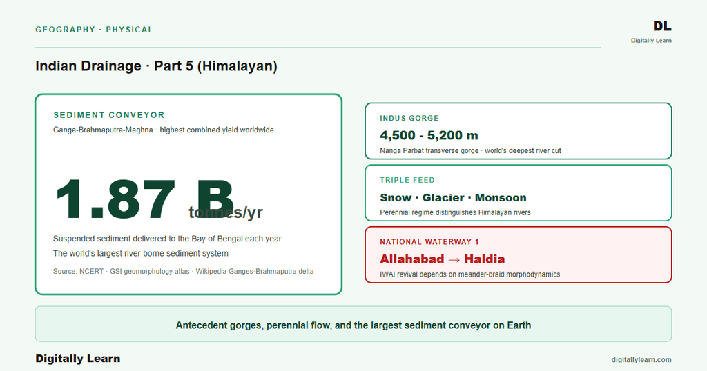
- Antecedent character with deep transverse gorges: The river predates the rising Himalayas and has incised vertically through the rising wedge, producing some of the world’s deepest river gorges, such as the Indus gorge near Nanga Parbat, which exceeds five thousand metres in relief.
- Very heavy sediment load delivered to the plains: The young, weak rocks of the Himalayan front yield prodigious quantities of silt and sand. The combined Ganga-Brahmaputra-Meghna system delivers about one point eight seven billion tonnes per year, the world’s highest recorded combined yield.
- Young, active fluvial geomorphology: The combination of heavy sediment plus high discharge produces continuously evolving channels, braided in the foothills and meandering in the plains, with frequent avulsion, oxbow formation, and floodplain reworking.
Perennial flow is the single most consequential of the four features for Indian civilisation. The spring snow-melt begins in March as the lower-elevation snowpack warms. It sustains river flow through what would otherwise be the driest pre-monsoon months. The summer glacier-melt then peaks in June and July, just as the Himalayan crops require irrigation.
The monsoon rainfall arrives in late June and continues through September. It produces the dramatic floods that define the lower reaches of the rivers. Because the three sources overlap in time, they smooth what would otherwise be sharp seasonal contrasts into a year-round usable flow.
Antecedent Gorges and the Sediment Conveyor to the Plains
The antecedent character of the Himalayan rivers was treated in detail in Part 4 of this series and is summarised here for completeness. The Indus, the Sutlej, and the Brahmaputra all rise on the Tibetan plateau. Each crosses the rising Himalayan range through a transverse gorge that it has cut downward by incising at roughly the same rate as the land has risen. Continuing uplift across the range drives this continuing incision.
The heavy sediment load is a direct consequence of that antecedent geometry. As the Himalaya rises, weak Tertiary rocks of the Siwalik foothills, weathered crystalline rocks of the higher ranges, and unconsolidated glacial deposits all yield easily to erosion. The young, weak front therefore feeds an enormous volume of silt and sand into the rivers each monsoon.
The output is the largest of its kind on record. The combined Ganga-Brahmaputra-Meghna system delivers about 1.87 billion tonnes per year of suspended sediment to the Bay of Bengal, the highest recorded annual yield of any combined river system in the world. This sediment built the entire Indo-Gangetic plain, which spreads over about 700,000 square kilometres across northern India, Pakistan, Nepal, and Bangladesh.
The Three-Stage Longitudinal Profile From Source to Mouth
How the Same River Expresses Three Geomorphic Personalities Along Its Length
The same Himalayan river takes on three distinct geomorphic personalities along its length. Each reach corresponds to a different balance between vertical incision and lateral migration as the gradient falls downstream.
- Youthful reach (Himalayan): From the source to the foothills the river runs through narrow V-shaped gorges with rapids and waterfalls. The dominant process is vertical incision; lateral migration is negligible because the bedrock walls confine the channel. Cross-section is steep-sided. Indus through Nanga Parbat and Brahmaputra through Namcha Barwa are the canonical examples.
- Mature reach (Siwalik foothills and Bhabhar): At the foot of the Himalaya the gradient drops sharply. The river drops its coarsest load on a fan-shaped Bhabhar belt of porous gravel and boulders. Channels divide into multiple braids around mid-channel sediment bars and migrate laterally. The Kosi alluvial fan is among the largest in the world, with the river showing lateral channel shifting exceeding one hundred and twenty kilometres across at least twelve major channels in the past two hundred and fifty years.
- Senile reach (Indo-Gangetic plain): On the plain the gradient is gentle and the river develops large meanders. Slow flow drops the finer silt as floodplain alluvium. Cut-off meanders form oxbow lakes; channels avulse during floods; deltas build seaward at the river mouth. The Ganga from Allahabad to the Sundarbans and the Brahmaputra across Assam show the mature meander-plus-braid mosaic at its fullest expression.
The Four Belts of the Indo-Gangetic Plain From Foothill to Active Channel
Bhabhar, Terai, Bhangar, and Khadar: The Sedimentary Stratigraphy on the Surface
Observable outcome: The Indo-Gangetic plain is not a single homogeneous flat surface. It is a sequence of four distinct sedimentary belts running parallel to the Himalayan front. Each belt records a different stage of the river's depositional history, from the coarse boulder fan at the mountain front to the fine silt of the active channel.
This four-belt geometry is the diagnostic surface expression of the Himalayan river system in its mature reach. It is also the primary reason the plain is among the most densely populated agricultural regions in the world.
- Bhabhar: A narrow region about seven to fifteen kilometres wide located immediately below the Siwalik foothills. The stretch is highly porous and is largely made up of stones and rocks carried by the rivers. Surface streams disappear into the porous gravel and resurface south of this belt.
- Terai: The second strip immediately south of the Bhabhar. The streams that vanished into the Bhabhar gravel re-emerge as springs here, producing wet evergreen vegetation and historically heavy malarial swampland. The region is largely made up of new silt deposited by the streams and rivers which reappear.
- Bhangar: The third strip consists of older alluvium deposited by the rivers and forms the major fertile region of the flood plains. It also consists of laterite deposits. Bhangar terraces stand above the level of the modern floods and carry most permanent settlement in the plain.
- Khadar: The last belt encompasses low-lying areas south of the Bhangar belt along the active river channel. It is largely composed of new silt carried by the rivers while flowing through the upper part of the plains. The Khadar is flooded every monsoon and is replenished with fresh silt each year.
The total area of the Indo-Gangetic plain is approximately seven hundred thousand square kilometres, making it among the largest continuous alluvial plains in the world. The four-belt structure repeats with local variations along the entire length of the Himalayan front from the Punjab plains in the west to the Brahmaputra valley in the east. The Bhabhar-Terai pair acts as a natural groundwater-recharge zone for the Indian Himalayan basin; the Bhangar-Khadar pair is the agricultural backbone of the country.
Channel Morphodynamics: Braided, Meandering, and the Aggradation Problem
Why the Brahmaputra Braids and the Ganga Meanders
Observable outcome: The Brahmaputra in its Assam reach is the textbook example of a braided river. The river is so wide that during the rains its banks lie more than eight kilometres apart, with the flow splitting into many channels around mid-channel sediment bars. Its average depth is about thirty metres, reaching a maximum of one hundred and thirty-five metres at Sadiya.
The discharge confirms the scale. The Brahmaputra's average discharge of about twenty-two thousand cubic metres per second can swell to roughly one hundred and three thousand cubic metres per second during floods. Its bank erosion rate has fallen to about thirty metres per year in the recent record, down from one hundred and fifty metres per year between 1973 and 1992.
The Ganga in its Bihar-West Bengal reach displays the contrasting meandering pattern. It carries a finer suspended load of silt and clay rather than gravel, runs on a gentler gradient, and has more cohesive banks. The river therefore develops broad sinuous meanders that migrate slowly across the floodplain. Where a meander loop is cut off during a flood, the abandoned arc becomes an oxbow lake.
Kanwar Lake (Kabartal) in Bihar is the classic Indian example. It formed from an abandoned meander of the Burhi Gandak river, a tributary of the Ganga, and is a designated Ramsar site often cited as among the largest freshwater oxbow lakes in Asia. Such oxbows record the meander history of the Ganga and its tributaries over recent centuries.
Why Floods in North India Have Intensified and What the Geomorphology Implies
Observable outcome: The frequency of floods in the North Indian plains has increased over recent decades. The geomorphic explanation is direct. The heavy sediment load delivered by the Himalayan rivers raises the channel bed faster than the river can scour it, a process called channel aggradation.
As the bed rises, the depth of the river valley relative to the surrounding plain decreases. A smaller volume of monsoon discharge is then enough to overtop the banks. The 2008 Kosi avulsion, when the river abruptly shifted its course across the Bihar plain, is the most dramatic recent expression of this mechanism.
The aggradation problem has policy consequences. Embankments built to constrain the channel trap sediment within the banks and accelerate the bed-rise, making the next breach more catastrophic than the last. Modern flood management therefore favours floodplain reactivation over rigid embankment, using the Khadar belt as a designed sediment trap that absorbs the peak monsoon discharge and releases water slowly. The Central Water Commission has reframed several Himalayan-basin flood-management strategies along these lines over the past decade.
Climate, Hydropower, and the Trans-Boundary Challenge
Glacier Retreat, Himalayan Hydropower, and Trans-Boundary Water Sharing
Contemporary linkages: The Himalayan river system carries three live policy challenges that its own geomorphology makes uniquely difficult to address. These are climate change acting on the glacial buffer, hydropower development at the steep mountain-foothill transition, and trans-boundary sharing of water that crosses international borders before reaching the sea.
- Climate change and the glacial buffer: Continued retreat of Himalayan glaciers is shrinking the long summer dry-season meltwater buffer that defines perennial flow. The Ministry of Environment, Forest and Climate Change runs the National Mission for Sustaining the Himalayan Ecosystem to track and respond to this shift.
- Hydropower at the mountain-foothill transition: The steep gradient and perennial flow give Indian Himalayan basins an estimated hydropower potential of over one hundred thousand megawatts. Several major projects in Uttarakhand and Himachal Pradesh have been commissioned, but landslide and flash-flood risk in the young, unstable Siwalik foothills constrains siting choices.
- Trans-boundary sharing: The Indus crosses into Pakistan, the Brahmaputra rises in China and exits to Bangladesh, and the Ganga flows out to Bangladesh as well. The Indus Waters Treaty of 1960, the Ganga Waters Treaty of 1996 with Bangladesh, and the ongoing Brahmaputra-system dialogue with China all rest on shared assumptions about flow regimes that the climate signal is steadily undermining.
The geomorphological reading of the Himalayan river system carries forward into every subsequent part of this series. Parts 6 and 7 walk the Indus and Ganga basins in detail. Parts 8 and 9 cover Ganga delta geomorphology and the Brahmaputra-Northeast system, and Part 15 closes with the floods-pollution-conservation synthesis.
The framework introduced here is the lens through which those later parts should be read. It covers perennial flow, antecedent gorges, the sediment conveyor, the four-belt floodplain, and the braided versus meandering channel contrast.
Prelims MCQ practice
Each question below tests one specific concept on the topic. Click to reveal the answer and a full option-wise explanation.
Q1. Consider the following statements about the Himalayan river system:
- The Himalayan rivers are fed by a triple source of snow melt, glacier melt, and monsoon rainfall.
- The combined Ganga-Brahmaputra-Meghna system delivers about one point eight seven billion tonnes of sediment per year to the Bay of Bengal.
- All Himalayan rivers are consequent streams aligned with the present regional slope.
Which of the statements given above are correct?
- 1 only
- 1 and 2 only
- 2 and 3 only
- 1, 2 and 3
Show answer and explanation
Answer: 1 and 2 only
Explanation.
Statement 1 is correct: snow melt in spring, glacier melt in summer, and monsoon rainfall in late summer together produce perennial flow. Statement 2 is correct: the combined Ganga-Brahmaputra-Meghna system is documented as the highest-yielding combined system in the world with about one point eight seven billion tonnes of suspended sediment annually. Statement 3 is incorrect: the major Himalayan rivers (Indus, Sutlej, Brahmaputra) are antecedent streams that cross the rising Himalayas through transverse gorges, not consequent streams.
Q2. Consider the following statements about the Indo-Gangetic floodplain belts:
- The Bhabhar belt is a narrow region about seven to fifteen kilometres wide located immediately below the Siwalik foothills.
- The Terai belt south of the Bhabhar is characterised by re-emerging springs and wet evergreen vegetation.
- Khadar refers to the older, terraced alluvium found further from the present river channel.
Which of the statements given above are correct?
- 1 only
- 1 and 2 only
- 2 and 3 only
- 1, 2 and 3
Show answer and explanation
Answer: 1 and 2 only
Explanation.
Statement 1 is correct on Bhabhar width and location. Statement 2 is correct on Terai vegetation and re-emerging streams. Statement 3 is incorrect: Khadar is the younger, active floodplain alluvium close to the present channel that is reworked by every monsoon flood. The older terraced alluvium further from the channel is Bhangar.
Q3. Consider the following statements about the three-stage longitudinal profile of a typical Himalayan river:
- The youthful reach in the Himalayan ranges is dominated by vertical incision and V-shaped gorges.
- The mature reach in the Siwalik foothills and Bhabhar shows braided channels and alluvial-fan deposition.
- The senile reach in the Indo-Gangetic plain develops meanders and oxbow lakes.
Which of the statements given above are correct?
- 1 only
- 1 and 2 only
- 2 and 3 only
- 1, 2 and 3
Show answer and explanation
Answer: 1, 2 and 3
Explanation.
All three statements describe the canonical youthful-mature-senile longitudinal sequence for the Himalayan river system, with each reach reflecting a different balance between vertical incision and lateral migration as the gradient decreases downstream.
Q4. Consider the following statements about channel morphodynamics in the Himalayan river system:
- The Brahmaputra is classified as a classic braided river whose banks lie more than eight kilometres apart during the rains in Assam.
- The Brahmaputra's bank-erosion rate has decreased to about thirty metres per year in the recent record, compared with about one hundred fifty metres per year between 1973 and 1992.
- Oxbow lakes such as Kanwar Lake in Bihar were formed by the meandering of Himalayan tributaries of the Ganga.
Which of the statements given above are correct?
- 1 only
- 1 and 2 only
- 2 and 3 only
- 1, 2 and 3
Show answer and explanation
Answer: 1, 2 and 3
Explanation.
All three statements are consistent with the Wikipedia Brahmaputra article: the braided pattern and banks more than eight kilometres apart during the rains, the erosion rate falling to about thirty metres per year from one hundred fifty metres per year in the 1973-1992 record, and the documented meander-oxbow origin of Kanwar Lake on the Burhi Gandak (a tributary of the Ganga).
Q5. Consider the following statements about flood frequency and channel geomorphology in the North Indian plains:
- Channel aggradation due to heavy sediment deposition can reduce the depth of the river valley and increase flood frequency.
- Embankments built to constrain channel migration tend to trap sediment within the banks and accelerate aggradation.
- Modern flood management strategies increasingly favour floodplain reactivation over rigid embankment.
Which of the statements given above are correct?
- 1 only
- 1 and 2 only
- 2 and 3 only
- 1, 2 and 3
Show answer and explanation
Answer: 1, 2 and 3
Explanation.
Each statement reflects the established hydrogeomorphological consensus on aggradation, embankment-induced sediment trapping, and the floodplain-reactivation paradigm adopted by Indian river basin agencies.
Sources
- India Physical Environment, Class 11, Chapter 3: Drainage System
- Ganges
- Brahmaputra River
- Indo-Gangetic Plain
- Indus River
- Kosi River
- Tectonic and Geomorphology Atlas of India
- Annual basin reports and flood-plain mapping
- National Mission for Sustaining the Himalayan Ecosystem
- Annual climate and rainfall summary
- River and floodplain monitoring layers
- National River Linking Project documents
Disclaimer
This article synthesises the canonical Indian textbook treatment of the Himalayan river system together with primary-source numerical values cited from official agencies and the Wikipedia primary articles. The geomorphic classifications follow the National Council of Educational Research and Training convention. Readers seeking primary citations for any specific number should consult the Sources block.


