
Overview
Previous Year UPSC-CSE Questions By the end you will be able to draft model answers for the following UPSC questions. Each question carries a collapsible framework showing how to approach it in the exam.
- Prelims 2020Which of the following Protected Areas are located in Cauvery basin ?
- Nagarhole National Park
- Papikonda National Park
- Sathyamangalam Tiger Reserve
- Wayanad Wildlife Sanctuary Select the correct answer using the code given below :
How to approach this Prelims question
Approach: Verify each protected area against the Cauvery basin boundary. Nagarhole (Karnataka) drains to Kabini and then to the Cauvery (Statement 1 correct). Papikonda (Andhra Pradesh) drains to the Godavari, NOT the Cauvery (Statement 2 incorrect). Sathyamangalam (Tamil Nadu) drains to the Bhavani and then to the Cauvery (Statement 3 correct). Wayanad (Kerala) drains to the Kabini and then to the Cauvery (Statement 4 correct).
Trap to watch: Papikonda is the trap: it is on the Eastern Ghats but drains to the Godavari, not the Cauvery; the resemblance to other Western Ghats reserves leads to wrong matching.
Key facts to recall:
- Nagarhole NP, Karnataka: drains via Kabini to Cauvery.
- Papikonda NP, Andhra Pradesh: drains to Godavari, not Cauvery.
- Sathyamangalam TR, Tamil Nadu: drains via Bhavani to Cauvery.
- Wayanad WLS, Kerala: drains via Kabini to Cauvery.
Answer signal: Nagarhole, Sathyamangalam, and Wayanad only (option c).
- Prelims 2019Consider the following pairs: Famous place – River
- Pandharpur : Chandrabhaga
- Tiruchirappalli : Cauvery
- Hampi : Malaprabha Which of the pairs given above are correctly matched?
How to approach this Prelims question
Approach: Verify each pair. Pandharpur in Maharashtra sits on the Chandrabhaga, a name for the Bhima river at that location (Statement 1 correct). Tiruchirappalli in Tamil Nadu sits on the Cauvery (Statement 2 correct). Hampi in Karnataka sits on the Tungabhadra, not the Malaprabha (Statement 3 incorrect).
Trap to watch: Hampi is the trap: it is on the Tungabhadra, not the Malaprabha. Both are Krishna tributaries that drain northern Karnataka and are often confused.
Key facts to recall:
- Pandharpur (Maharashtra): on the Bhima, locally called Chandrabhaga.
- Tiruchirappalli (Tamil Nadu): on the Cauvery.
- Hampi (Karnataka): on the Tungabhadra, Vijayanagara capital.
- Malaprabha is a separate Krishna tributary in northern Karnataka.
Answer signal: Only Pairs 1 and 2 are correct (option a).
- Prelims 2008Which of the following pairs are correctly matched? Waterfalls – River
- Kapildhara Falls : Godavari
- Jog Falls : Sharavati
- Sivasamudram Falls : Cauvery Select the correct answer using the code given below:
How to approach this Prelims question
Approach: Verify each pair. Kapildhara Falls sit on the Narmada at Amarkantak, NOT on the Godavari (Statement 1 incorrect). Jog Falls sit on the Sharavati in Karnataka (Statement 2 correct). Sivasamudram Falls sit on the Cauvery in Karnataka (Statement 3 correct).
Trap to watch: Kapildhara is the trap: it is on the Narmada near Amarkantak (which also gives rise to the Sone and the Mahanadi), not the Godavari.
Key facts to recall:
- Kapildhara Falls: Narmada, near Amarkantak.
- Jog Falls: Sharavati, Karnataka (one of India's tallest plunge waterfalls).
- Sivasamudram Falls: Cauvery, Karnataka.
- Hogenakkal Falls: Cauvery, at the Karnataka-Tamil Nadu border.
Answer signal: Only Pairs 2 and 3 are correct (option b).
- UPSC Mains 2018 GS-IIHow far do you agree with the view that tribunals curtail the jurisdiction of ordinary courts? In view of the above, discuss the constitutional validity and competency of the tribunals in India.
How to structure the answer in the exam
Introduction: Tribunals in India are constituted under Articles 323A and 323B of the Constitution and the Inter-State River Water Disputes Act 1956. The Cauvery dispute is the leading example of tribunal-and-Supreme-Court interaction: the Cauvery Water Disputes Tribunal delivered its final award on 5 February 2007 and the Supreme Court delivered its definitive verdict on 16 February 2018, effectively modifying the tribunal award.
Conclusion: Tribunals do not constitutionally curtail Supreme Court jurisdiction (L. Chandra Kumar), but in practice the Cauvery case demonstrates persistent process inadequacy of the tribunal mechanism; reform requires a permanent inter-state water tribunal with binding awards and time-bound process plus integration with climate-driven flow-regime updates.
Why the Krishna-Kaveri Family Is the Centre of Indian Water-Dispute Governance
The Krishna and the Kaveri as the Twin Anchors of South Indian Drainage
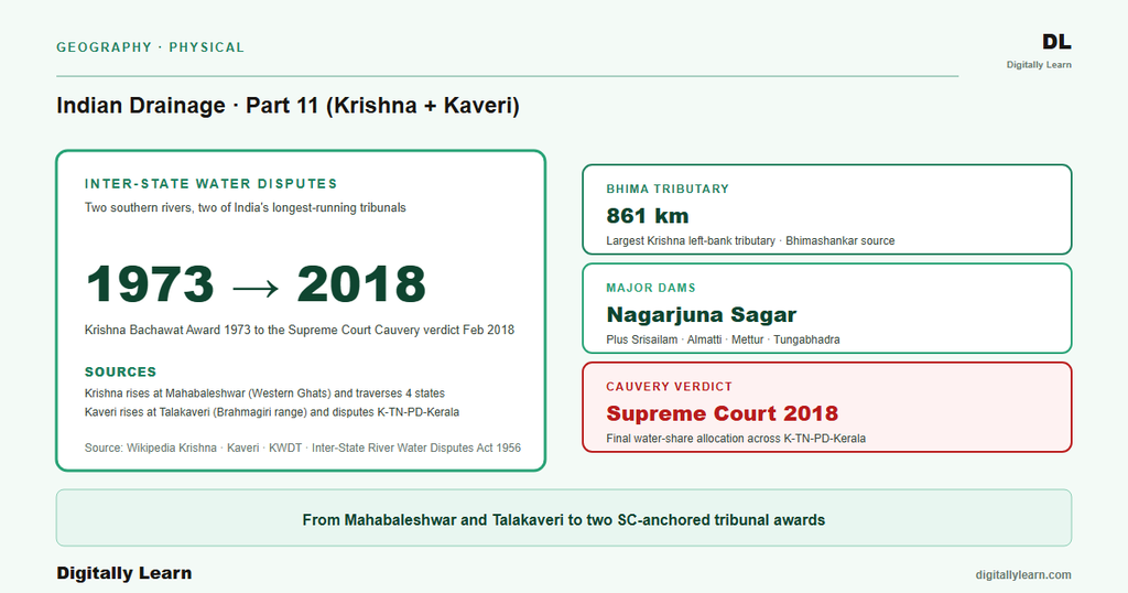
The Krishna and the Kaveri are the two largest Peninsular east-flowing rivers between the Godavari (Part 10) and the southern tip of the peninsula. Both rise on the Western Ghats, cross the Deccan plateau eastward, and reach the Bay of Bengal through coastal deltas. The Krishna runs about 1,400 km from Mahabaleshwar to the Hamsaladeevi delta in Andhra Pradesh; the Kaveri runs about 800 km from Talakaveri to its Tamil Nadu delta.
Why it matters: The two rivers together drain about three hundred and forty thousand square kilometres across five Indian states (Maharashtra, Karnataka, Telangana, Andhra Pradesh, Tamil Nadu) plus Kerala and the Union Territory of Puducherry. Their basins host four of India's most-litigated inter-state water disputes: KWDT-I (1969-1973), KWDT-II (2004-2013), CWDT (1990-2007), and the 2018 Supreme Court Cauvery verdict. The Krishna-Kaveri family is therefore the leading case study for how the constitutional water-disputes architecture functions in practice.
Why the Krishna-Kaveri Family Defines the Indian Water-Disputes Architecture
What is the significance of the Krishna-Kaveri family for Indian water governance: Three features make it the dominant test case for the dispute-resolution mechanism. First, the rivers cross several state boundaries with sharply differing political alignments, generating recurring escalation. Second, the riparian states hold unequal claims: upstream Karnataka and Maharashtra hold geographic position, downstream Tamil Nadu and Andhra Pradesh hold prior-use claims. Third, the architecture has matured across both Tribunal-and-Court interaction (Cauvery) and Tribunal-revision interaction (Krishna).
| Attribute | Krishna | Kaveri |
|---|---|---|
| Source location | Mahabaleshwar (Jor village), Satara district, Maharashtra | Talakaveri, Brahmagiri Hills, Kodagu district, Karnataka |
| Source elevation | Approximately 914 m | Approximately 1,341 m |
| Total length | About 1,400 km | About 800 km |
| Basin area | About 258,948 km² | About 81,155 km² |
| Mouth | Hamsaladeevi, Krishna district, Andhra Pradesh | Poompuhar delta in Tamil Nadu |
| Primary dispute tribunals | KWDT-I (Bachawat 1973), KWDT-II (Brijesh Kumar 2013) | CWDT (1990 to 2007), SC verdict 16 Feb 2018 |
| Marquee dams | Almatti, Srisailam, Nagarjuna Sagar, Tungabhadra | KRS 49.5 tmc ft (Karnataka), Mettur 93.5 tmc ft (Tamil Nadu) |
| Number of riparian states | Four (Maharashtra, Karnataka, Andhra Pradesh, Telangana) | Three states plus one Union Territory (Karnataka, Tamil Nadu, Kerala, Puducherry) |
The Krishna System From Mahabaleshwar to Hamsaladeevi
Source at Mahabaleshwar and Course Across Four States
The Krishna rises near Mahabaleshwar at Jor village in Satara district of Maharashtra at about 914 m. The river runs about 1,400 km through Maharashtra, Karnataka, Telangana, and Andhra Pradesh before reaching the Bay of Bengal at Hamsaladeevi in Krishna district. Its basin area is about 258,948 sq km, the second-largest Peninsular basin after the Godavari.
The Krishna's course passes through three reaches. The upper reach across the Western Ghats and the Maharashtra plateau receives the Venna, the Koyna (behind the Koyna Dam), and the Panchganga. The middle reach across northern Karnataka and Telangana receives the right-bank Ghataprabha, Malaprabha, and Tungabhadra and the left-bank Bhima. The lower reach in coastal Andhra Pradesh accepts the Musi (through Hyderabad) and reaches the sea through the Krishna delta near Vijayawada.
Krishna Tributaries and the Almatti-Srisailam-Nagarjuna Sagar Reservoir Chain
The Krishna accepts tributaries on both banks across its course. The right-bank tributaries drain the Western Ghats and the eastern Maharashtra plateau. The left-bank tributaries drain the Deccan plateau from the north.
- Bhima: Left-bank tributary; rises on the Bhimashankar range in Maharashtra and runs about 861 kilometres before joining the Krishna in Karnataka.
- Tungabhadra: Right-bank tributary formed by the confluence of the Tunga and the Bhadra in Karnataka; carries the Tungabhadra Dam and Hampi (the Vijayanagara capital) sits on its banks.
- Ghataprabha and Malaprabha: Two right-bank tributaries rising on the Western Ghats and joining the Krishna in northern Karnataka.
- Koyna: Right-bank tributary impounded by the Koyna Dam in Maharashtra; the 1967 Koyna earthquake established this reach as a globally cited reservoir-induced seismicity case.
- Musi: Left-bank tributary passing through Hyderabad before joining the Krishna in southern Telangana.
Three large reservoirs dominate the operational geography of the Krishna. The Almatti Dam (Karnataka) is the upstream anchor and was central to the KWDT-II reservoir-height dispute; the Srisailam Dam (Telangana-Andhra Pradesh) sits in the middle reach. The Nagarjuna Sagar Dam was the tallest masonry dam in the world at its completion in 1967, 124 m high and 1.55 km long. The Krishna's mouth is the Hamsaladeevi delta in Andhra Pradesh.
The Kaveri System From Talakaveri to the Poompuhar Delta
Source at Talakaveri and Course Through Karnataka and Tamil Nadu
The Kaveri rises at Talakaveri in the Brahmagiri Hills of the Western Ghats within Kodagu district of Karnataka at about 1,341 m. The river runs about 800 km through Karnataka and Tamil Nadu before reaching the Bay of Bengal at the Poompuhar delta. Its basin area is about 81,155 sq km, far smaller than the Krishna or the Godavari but covering some of the most densely cultivated land in southern India.
The Kaveri's course parallels the Krishna in three reaches. The upper reach across the Kodagu hills and southern Karnataka plateau receives the Hemavati, the Lakshmana Tirtha, and the Harangi. The middle reach anchors the Krishna Raja Sagara reservoir near Mysore, and at the border the river drops over the Hogenakkal Falls into Tamil Nadu. The lower reach is anchored by the Mettur Stanley Reservoir, takes the Bhavani, Noyyal, and Amaravati, and reaches the sea at the Poompuhar delta.
Kaveri Tributaries, the KRS-Mettur Pair, and the Twenty-One-Tributary Network
The Kaveri receives twenty-one major tributaries across both states. The Karnataka tributaries include the Hemavati, the Kabini, the Lakshmana Tirtha, the Shimsha, the Arkavati, the Harangi, and the Sarabanga. The Tamil Nadu tributaries include the Bhavani, the Noyyal, and the Amaravati. The Kabini and the Hemavati between them carry the heaviest tributary discharge.
Two large reservoirs anchor the operational geography. The Krishna Raja Sagara (KRS) reservoir near Mysore holds about 49.5 tmc ft and is the second-largest dam on the river. The Mettur Dam in Tamil Nadu, completed in 1934 and forming the Stanley Reservoir, holds about 93.5 tmc ft. The KRS-Mettur pair is the physical basis of the Cauvery dispute: release from KRS sets Mettur inflow, which sets Tamil Nadu kuruvai and samba irrigation.
Inter-State Water Disputes: KWDT, CWDT, and the 2018 Supreme Court Cauvery Verdict
KWDT-I Bachawat Award 1973 and KWDT-II Brijesh Kumar Award 2013
The Krishna Water Disputes Tribunal first (KWDT-I) was constituted on 10 April 1969 under the Inter-State River Water Disputes Act 1956 over Krishna water sharing between Maharashtra, Karnataka, and Andhra Pradesh. Chaired by Justice R. S. Bachawat, it delivered its final award in 1973, gazetted on 31 May 1976. The award allotted 560 TMC to Maharashtra, 700 TMC to Karnataka, and 800 TMC to the then-undivided Andhra Pradesh at 75 per cent dependability.
The Krishna Water Disputes Tribunal second (KWDT-II) was constituted in April 2004 after disputes resurfaced over reservoir heights, notably Karnataka's Almatti Dam. Chaired by Justice Brijesh Kumar, it delivered its final award on 29 November 2013, allotting 1,001 TMC to Andhra Pradesh, 911 TMC to Karnataka, and 666 TMC to Maharashtra at 65 per cent dependability. Telangana was later added as the fourth riparian state after its 2014 statehood, with the further sub-allocation still contested.
CWDT 1990, the 2007 Award, the 2018 Supreme Court Verdict, and CWMA
The Cauvery Water Disputes Tribunal (CWDT) was constituted on 2 June 1990 by a Supreme Court order over the dispute between Karnataka, Tamil Nadu, Kerala, and Puducherry. It delivered its final award on 5 February 2007, which Karnataka and Tamil Nadu challenged. The Court's verdict of 16 February 2018 allotted 284.75 TMC to Karnataka, 404.25 TMC to Tamil Nadu, 30 TMC to Kerala, and 7 TMC to Puducherry, plus 10 TMC for the environment and 4 TMC for wastage.
The 2018 verdict additionally directed the Cauvery Water Management Authority (CWMA), formed in June 2018. CWMA is supported by the Cauvery Water Regulation Committee (CWRC), which advises on monthly water releases from Karnataka to Tamil Nadu through the KRS-Mettur chain covered in Section 3. The Cauvery dispute is the leading example of tribunal-and-Supreme-Court interaction, the focus of the 2018 UPSC Mains question on tribunals and the jurisdiction of ordinary courts.
River Linking, Climate, and the Future of the Krishna-Kaveri Disputes
How the Disputes Apparatus Faces Climate-Driven Monsoon Variability
Contemporary linkages: Three forward-looking pressures shape the next decade of Krishna-Kaveri governance. First, the National River Linking Project southern arm proposes a Pennar-Cauvery-Vaigai-Gundar link to transfer Krishna and Godavari surplus to the Cauvery basin. The Pattiseema Lift (Part 10) is the operational prototype; the wider link remains under study at the National Water Development Agency. Second, climate change is intensifying monsoon variability across both basins, undermining the 75 per cent and 65 per cent dependability assumptions in the KWDT awards.
Third, the tribunal mechanism itself faces structural strain. The 2018 Supreme Court verdict effectively modified the 2007 CWDT award, raising whether tribunals retain final authority or operate as advisory bodies under the Court. The renegotiation of the Krishna-Telangana sub-allocation, the maturing of CWMA, and the climate-driven re-evaluation of dependability will decide whether the constitutional architecture of Part 9 (Article 262, Inter-State River Water Disputes Act 1956) remains fit for purpose.
Parts 12 to 15 turn to the Peninsular west-flowing rivers plus the inland Luni (Part 12), the riverine landforms toolkit (Part 13), drainage and the Indian economy and river linking (Part 14), and the synthesis on floods, pollution, conservation, and climate change (Part 15). Across Parts 6 to 11 the cumulative picture is that India's major basins are at once the foundation of its agricultural and cultural geography and the centre of its most-litigated water disputes.
Prelims MCQ practice
Each question below tests one specific concept on the topic. Click to reveal the answer and a full option-wise explanation.
Q1. Consider the following statements about the Krishna river:
- The Krishna rises near Mahabaleshwar in Satara district of Maharashtra at an elevation of about nine hundred and fourteen metres.
- The total length of the Krishna is about one thousand four hundred kilometres.
- The Krishna empties into the Arabian Sea through a delta in Maharashtra.
Which of the statements given above are correct?
- 1 and 2 only
- 1 only
- 2 and 3 only
- 1, 2 and 3
Show answer and explanation
Answer: 1 and 2 only
Explanation.
Statement 1 is correct: the Krishna rises near Mahabaleshwar at Jor village at about 914 m. Statement 2 is correct: its length is about 1,400 km. Statement 3 is the trap: the Krishna is an east-flowing river that empties into the Bay of Bengal at Hamsaladeevi in Andhra Pradesh, not the Arabian Sea.
Q2. Consider the following statements about the Kaveri river:
- The Kaveri rises at Talakaveri in the Brahmagiri Hills of Kodagu district of Karnataka at an elevation of about one thousand three hundred and forty-one metres.
- Hemavati and Kabini are major Karnataka tributaries of the Kaveri.
- The Kaveri forms the Hogenakkal Falls as it enters Tamil Nadu.
Which of the statements given above are correct?
- 1 only
- 1 and 2 only
- 2 and 3 only
- 1, 2 and 3
Show answer and explanation
Answer: 1, 2 and 3
Explanation.
Statement 1 is correct: the Kaveri rises at Talakaveri at about 1,341 m. Statement 2 is correct: the Hemavati and the Kabini are major Karnataka tributaries. Statement 3 is correct: the river drops over the Hogenakkal Falls as it crosses into Tamil Nadu. A common distractor is to pair the Kaveri with the Sivasamudram Falls only; both Sivasamudram and Hogenakkal sit on the Kaveri.
Q3. Consider the following statements about the Krishna Water Disputes Tribunal:
- KWDT-I, chaired by Justice R. S. Bachawat, delivered its final award in 1973, which was published in the Gazette in 1986.
- KWDT-II was chaired by Justice Brijesh Kumar and delivered its final award on 29 November 2013.
- Telangana was added as the fourth riparian state to the Krishna dispute following its 2014 statehood.
Which of the statements given above are correct?
- 1 and 2 only
- 2 and 3 only
- 1 and 3 only
- 1, 2 and 3
Show answer and explanation
Answer: 2 and 3 only
Explanation.
Statement 1 is the trap: the KWDT-I award of 1973 was published in the Extraordinary Gazette on 31 May 1976, not 1986. Statement 2 is correct: the Brijesh Kumar KWDT-II award was delivered on 29 November 2013. Statement 3 is correct: Telangana became the fourth riparian state after its 2014 statehood.
Q4. Consider the following statements about the Cauvery water dispute:
- The Cauvery Water Disputes Tribunal (CWDT) was constituted in 1956 directly under the Inter-State River Water Disputes Act, without any Supreme Court direction.
- The CWDT delivered its final award on 5 February 2007.
- The Supreme Court delivered its definitive Cauvery verdict on 16 February 2018, after which the Cauvery Water Management Authority was formed in June 2018.
Which of the statements given above are correct?
- 1 and 2 only
- 1 and 3 only
- 2 and 3 only
- 1, 2 and 3
Show answer and explanation
Answer: 2 and 3 only
Explanation.
Statement 1 is the trap: the CWDT was constituted on 2 June 1990 by a Supreme Court order (not in 1956), although the enabling statute is the Inter-State River Water Disputes Act 1956. Statement 2 is correct: the final award came on 5 February 2007. Statement 3 is correct: the Supreme Court's 16 February 2018 verdict modified that award, after which the CWMA was formed in June 2018.
Q5. Consider the following Cauvery water allocations under the Supreme Court's 16 February 2018 verdict:
- Karnataka was allocated four hundred and four point two five TMC.
- Tamil Nadu was allocated four hundred and four point two five TMC.
- Kerala was allocated thirty TMC and Puducherry was allocated seven TMC.
Which of the statements given above are correct?
- 1 and 2 only
- 2 and 3 only
- 1 and 3 only
- 1, 2 and 3
Show answer and explanation
Answer: 2 and 3 only
Explanation.
Statement 1 is the trap: Karnataka was allocated 284.75 TMC, not 404.25 TMC; the 404.25 TMC share belongs to Tamil Nadu. Statement 2 is correct: Tamil Nadu received 404.25 TMC. Statement 3 is correct: Kerala received 30 TMC and Puducherry 7 TMC, with a further 10 TMC reserved for the environment and 4 TMC for wastage into the sea.
Sources
- India Physical Environment, Class 11, Chapter 3: Drainage System
- Krishna River
- Kaveri River
- Krishna Water Disputes Tribunal
- Tungabhadra River
- Nagarjuna Sagar Dam
- Mettur Dam
- Krishna Raja Sagara
- Krishna and Cauvery basin reports
- Pennar-Cauvery-Vaigai-Gundar river-linking documents
- Cauvery Water Management Authority and CWRC records
- Supreme Court Cauvery verdict and CWMA releases
Disclaimer
This article presents the Krishna and Kaveri river systems and their inter-state water disputes for UPSC preparation. River lengths, source elevations, basin areas, tribunal award allocations, and the Supreme Court Cauvery verdict are drawn from the authoritative public sources listed below. For the operational details of the Cauvery Water Management Authority, consult the Ministry of Jal Shakti and Central Water Commission portals.


