
Overview
Previous Year UPSC-CSE Questions By the end you will be able to draft model answers for the following UPSC questions. Each question carries a collapsible framework showing how to approach it in the exam.
- Prelims 2021With reference to the Indus river system, of the following four rivers, three of them pour into one of them which joins the Indus direct. Among the following, which one is such river that joins the Indus direct?
How to approach this Prelims question
Approach: Work backwards from the trunk Indus: the Panjnad confluence near Mithankot is the point where the five Punjab tributaries meet the trunk. Within the Panjnad system, the Sutlej is the river into which the Chenab, the Ravi, and the Jhelum eventually merge before the combined flow joins the trunk Indus.
Trap to watch: Chenab is the largest of the tributaries by length and discharge and is sometimes wrongly chosen because the Jhelum and Ravi merge into it before the Panjnad confluence; but the standard UPSC answer recognises the Sutlej as the trunk-line river of the Panjnad that joins the Indus.
Key facts to recall:
- Jhelum joins Chenab at Trimmu in Jhang district.
- Beas joins Sutlej at Harike.
- Ravi joins Chenab in Pakistan.
- Chenab joins Sutlej; the combined river is called Panjnad.
- Panjnad joins the trunk Indus near Mithankot.
Answer signal: Sutlej (option d).
- Prelims 2014Consider the following pairs : Wetlands – Confluence of rivers
- Harike Wetlands : Confluence of Beas and Satluj/Sutlej
- Keoladeo Ghana National Park : Confluence of Banas and Chambal
- Kolleru Lake : Confluence of Musi and Krishna
Which of the above pairs is/are correctly matched?
How to approach this Prelims question
Approach: Verify each pair. Harike at Beas-Sutlej confluence (Indus system) is correct. Keoladeo Ghana is in Bharatpur and is fed by the Gambhir and Banganga, not Banas-Chambal. Kolleru sits in the Krishna-Godavari delta and is fed by the Budameru and Tammileru, not Musi-Krishna.
Trap to watch: All three pairs sound plausible because each names a wetland and two rivers in the same region; only the Harike pair matches the actual hydrology.
Key facts to recall:
- Harike Wetlands at the Beas-Sutlej confluence in Punjab.
- Keoladeo Ghana in Bharatpur, fed by the Gambhir.
- Kolleru Lake between Krishna and Godavari, fed by Budameru and Tammileru.
Answer signal: Only Pair 1 is correct (option a).
- Prelims 2009Consider the following statements about the Baglihar Power Project:
- The Baglihar Power Project had been constructed within the parameters of the Indus Water Treaty.
- The project was completely built by the Union Government with loans from Japan and the World Bank.
Which of the statements given above is/are correct?
How to approach this Prelims question
Approach: Verify each statement. Statement 1 is correct: the Neutral Expert appointed by the World Bank held that Baglihar could be constructed within IWT parameters subject to design modifications. Statement 2 is incorrect: Baglihar was constructed by the Government of Jammu and Kashmir under the National Hydroelectric Power Corporation, not by the Union Government with Japan-World Bank loans.
Trap to watch: The IWT-compliance side of the question is easy to confirm; the financing side is trickier because Japan and the World Bank do finance Indian hydropower elsewhere.
Key facts to recall:
- Baglihar Dam on the Chenab; 900 MW capacity.
- Neutral Expert appointed by the World Bank; ruling permits construction within IWT.
- Built by Jammu and Kashmir State Power Development Corporation, not the Union directly.
- Project financing did not come from a Japan-World Bank loan combination.
Answer signal: Statement 1 only is correct (option a).
- UPSC Mains 2016 GS-IPresent an account of the Indus Water Treaty and examine its ecological, economic and political implications in the context of changing bilateral relations.
How to structure the answer in the exam
Introduction: Signed on 19 September 1960 in Karachi by Nehru and Ayub Khan with the World Bank as broker and depositary, the Indus Waters Treaty allocates the three eastern rivers (Ravi, Beas, and Sutlej) to India and the three western rivers (Indus, Jhelum, and Chenab) to Pakistan.
Conclusion: The treaty's first six decades demonstrated that hostile political conditions need not preclude water cooperation; its next phase will be defined by whether the 1960 allocation arithmetic can be reworked to absorb climate-driven flow shifts and post-2023 political pressures, or whether the suspension regime becomes the new normal.
What the Indus River System Is: Trunk River, Five Punjab Tributaries, and the 1960 Treaty
The Indus System as a Trans-Himalayan Drainage Family
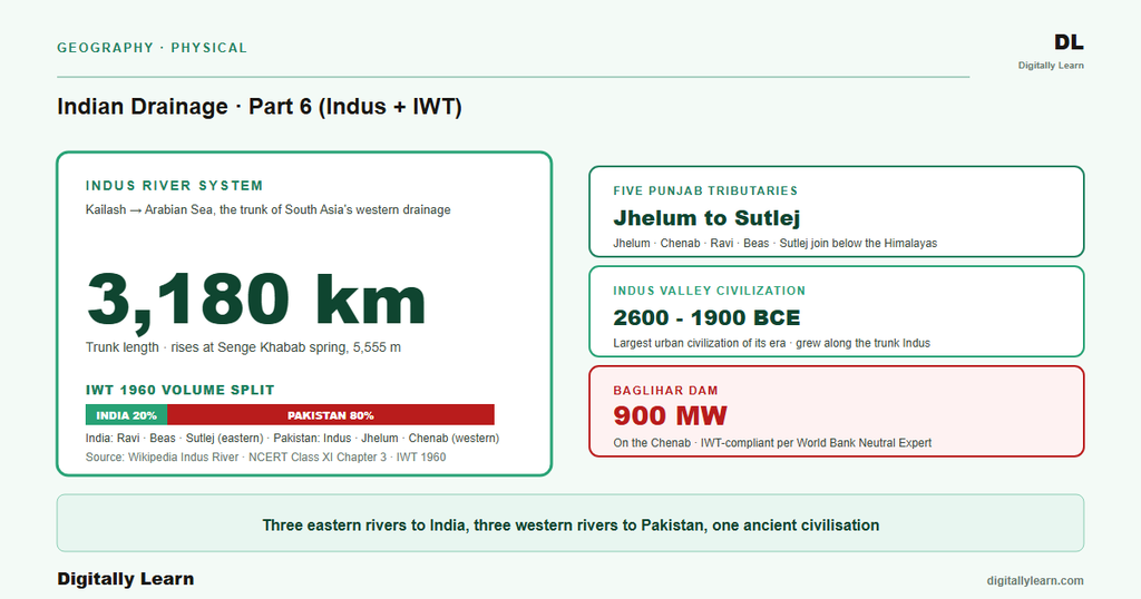
Definition: The Indus river system is the family of one trunk river and five major Punjab tributaries that drain the western Himalayan slopes and the Punjab plains before emptying into the Arabian Sea. The trunk Indus rises on the Tibetan plateau, cuts a deep transverse gorge at Nanga Parbat, crosses the Punjab plains, and reaches the sea through the Sindh delta in Pakistan.
The five Punjab tributaries are the Jhelum, the Chenab, the Ravi, the Beas, and the Sutlej. Together with the trunk, these are the six rivers divided between the two countries under the 1960 settlement.
Why it matters: The Indus system irrigates roughly two-thirds of Pakistan's agricultural land and supports nearly the whole of Indian Punjab and Indian-administered Kashmir. For UPSC it spans physical geography (Himalayan drainage), polity and international relations (the Indus Waters Treaty), and contemporary affairs (the 2025 suspension).
Under the treaty arithmetic, India holds about thirty-three million acre-feet of mean annual flow from the three eastern tributaries (Ravi, Beas, Sutlej) and Pakistan about one hundred and thirty-five million acre-feet from the three western rivers (Indus, Jhelum, Chenab). The system is the operational core of the partition-era water settlement between India and Pakistan.
The Indus Valley Civilization and the Long History of Settlements Over Indus Water
What is the significance of the Indus system for South Asian history? The Indus Valley Civilization, dated to roughly 2600 to 1900 BCE, was the world's largest urban civilization of its era. It grew along the trunk Indus, the Ghaggar-Hakra paleochannel (covered in Part 4), and the lower courses of the Punjab tributaries.
Mohenjo-daro sat on the Indus south of Sukkur and Harappa sat on the Ravi. Successive polities, from the Persian Achaemenids to the Mughals to the British Raj, organised their north-western frontier around this drainage. The 1960 treaty is the latest in a long sequence of settlements over Indus water that have shaped the political geography of South Asia.
| River | Source | Length (km) | IWT classification | Major dam |
|---|---|---|---|---|
| Indus (trunk) | Senge Khabab near Mount Kailash, Tibet, 5,555 m | 3,180 | Western (Pakistan) | Tarbela (Pakistan) |
| Jhelum | Verinag Spring, Kashmir Valley | 725 | Western (Pakistan) | Mangla 1,070 MW (Pakistan); Kishanganga 330 MW (India) |
| Chenab | Chandra and Bhaga confluence at Tandi, Himachal Pradesh | 974 | Western (Pakistan) | Salal 690 MW and Baglihar 900 MW (India) |
| Ravi | Bara Bhangal, Kangra district, Himachal Pradesh | 720 | Eastern (India) | Ranjit Sagar / Thein Dam 600 MW (India) |
| Beas | Rohtang Pass, Kullu, Himachal Pradesh, 4,361 m | 470 | Eastern (India) | Pong / Maharana Pratap Sagar 396 MW (India) |
| Sutlej | Rakas Tal / Mansarovar, Tibet, 4,575 m | 1,450 | Eastern (India) | Bhakra 1,325 MW (India) |
The Main Indus From Mount Kailash to the Arabian Sea
Source on the Tibetan Plateau and the Nanga Parbat Gorge
The trunk Indus rises at the Senge Khabab spring at an elevation of about five thousand five hundred and fifty-five metres near Mount Kailash in Tibet. The Wikipedia Indus article identifies it as an antecedent stream that existed before the Himalayas and entrenched itself as they rose (antecedent drainage was covered in Part 4).
The first thousand kilometres run north-west across the Tibetan plateau. The river then bends sharply south-west at the Nanga Parbat syntaxis and cuts a transverse gorge into the rising Himalayan wedge, one of the deepest river gorges on Earth.
The Nanga Parbat gorge is documented by the Wikipedia article at four thousand five hundred to five thousand two hundred metres deep, deeper than any peak in the European Alps. South of the gorge the river enters Gilgit-Baltistan and picks up the Shyok, the Shigar, and the Gilgit tributaries from the Karakoram.
The Indus continues to incise its bed because the Himalayan front keeps rising at about five millimetres per year on average, with the western syntaxis at Nanga Parbat near seven millimetres per year per the Wikipedia Himalayas article. The river then turns south-west into Pakistan.
The Punjab Plains, the Panjnad Confluence, and the Sindh Delta
From the gorges of the Karakoram the Indus enters the Punjab plains of Pakistan and runs south to the Arabian Sea. The trunk receives the trans-Karakoram Kabul tributary from the west near Attock, then accepts the combined flow of its five Punjab tributaries through the Panjnad confluence near Mithankot.
Below Mithankot the trunk runs the length of Sindh province and reaches the Arabian Sea through a complex deltaic estuary near Karachi. The Wikipedia article documents the trunk at three thousand one hundred and eighty kilometres from source to mouth, with the Tarbela reservoir upstream and the Kotri Barrage downstream.
The Indus delta has changed markedly over historical time. The 1819 Allah Bund earthquake in the Rann of Kutch produced a tectonic uplift that dammed the easternmost Nara channel and shifted the main course westward, a process covered in Part 4 of this series.
November 2011 satellite imagery cited by the Wikipedia Indus article recorded the trunk briefly re-entering Indian territory through the Great Rann of Kachchh during exceptional monsoon flooding, a reminder that the lower Indus remains a shifting deltaic system.
The Five Punjab Tributaries Walked One by One
Distinguishing Features of Jhelum, Chenab, Ravi, Beas, and Sutlej
The five Punjab tributaries differ in source, course, and treaty classification. The Jhelum and the Chenab are western rivers under the Indus Waters Treaty and are reserved mainly for Pakistan's use.
The Ravi, the Beas, and the Sutlej are eastern rivers reserved for India. All five rise on the Indian side of the Line of Control and cross into Pakistan before merging at the Panjnad confluence.
- Jhelum: Rises at the Verinag Spring in the Kashmir Valley; flows north-west through Srinagar and Wular Lake; total length seven hundred and twenty-five kilometres per the Wikipedia Jhelum article; joins the Chenab at the Trimmu confluence in Jhang district, Pakistan; carries the Kishanganga (330 MW) project in India and the Mangla Dam (1,070 MW) in Pakistan.
- Chenab: Formed by the confluence of the Chandra and the Bhaga at Tandi in Himachal Pradesh, eight kilometres south-west of Keylong; total length nine hundred and seventy-four kilometres; carries the Salal (690 MW) and Baglihar (900 MW) hydropower projects in India; receives the Jhelum at Trimmu and the Ravi en route to its merger with the Sutlej at the Panjnad.
- Ravi: Rises in the Bara Bhangal region of Kangra district, Himachal Pradesh, at about four thousand three hundred metres; total length seven hundred and twenty kilometres per the Wikipedia Ravi article; eastern river under the Indus Waters Treaty; carries the Ranjit Sagar (Thein) Dam with 600 MW capacity; flows past Lahore on its eastern bank.
- Beas: Rises four thousand three hundred and sixty-one metres above sea level on the southern face of Rohtang Pass in Kullu, Himachal Pradesh; total length four hundred and seventy kilometres; eastern river under the Indus Waters Treaty; carries the Pong Dam (Maharana Pratap Sagar) of 396 MW capacity; joins the Sutlej at Harike Barrage at the south-western boundary of Kapurthala district.
- Sutlej: Rises in the Manasarovar-Rakas Tal lakes in Tibet at four thousand five hundred and seventy-five metres; total length one thousand four hundred and fifty kilometres; longest of the five tributaries and the only one with a Tibetan source like the trunk Indus; carries the Bhakra Dam (1,325 MW) in India; receives the Beas at Harike, unites with the Chenab to form the Panjnad, and the Panjnad finally joins the trunk Indus near Mithankot.
The Indus Waters Treaty of 1960: How the Allocation Works
Karachi 1960, the Three Eastern and Three Western Rivers, and the World Bank
Signing and the World Bank's role: The Indus Waters Treaty was signed on 19 September 1960 in Karachi by Indian Prime Minister Jawaharlal Nehru, Pakistani President Mohammad Ayub Khan, and W. A. B. Iliff, a World Bank Vice-President signing as the Bank's representative.
The treaty followed nine years of World-Bank-brokered negotiation begun under Bank President Eugene Black. It resolved the post-Partition dispute over how the six rivers of the Indus system should be divided between India and Pakistan.
The eastern-river share: The treaty allocates the three eastern rivers (Ravi, Beas, Sutlej) to India for unrestricted use. These carry about thirty-three million acre-feet of mean annual flow, roughly twenty per cent of the system's total volume.
The three western rivers (Indus trunk, Jhelum, Chenab) are allocated to Pakistan and carry about one hundred and thirty-five million acre-feet, roughly eighty per cent of total volume. India retains limited non-consumptive use of the western rivers for run-of-river hydropower, subject to design constraints in the treaty annexures.
Permanent Indus Commission: The Operating Mechanism
A standing bilateral channel: The treaty established the Permanent Indus Commission as a bilateral body with one commissioner appointed by each country. The Commission must meet at least annually and is the first port of call for technical disputes between the two governments.
The one hundred and eighteenth meeting of the Commission was held in May 2022 per the Wikipedia treaty article. The Commission has been resilient to political tension, continuing to function across the 1965, 1971, and 1999 conflicts.
Disputes the Commission cannot resolve escalate through two further tiers. A Neutral Expert appointed by the World Bank handles purely technical questions of design or engineering, while a Court of Arbitration handles questions of treaty interpretation that exceed engineering scope.
These tiers worked smoothly through the treaty's first four decades. They have come under increasing strain over the past twenty years as Indian run-of-river hydropower projects on the western rivers have grown in number and scale.
Named Disputes, the 2023 Notice, and the 2025 Suspension
Baglihar, Kishenganga, and Ratle: Three Indian Hydropower Projects on Western Rivers
Three Indian hydropower projects on the western rivers have been the leading test cases of the treaty's dispute architecture. The Baglihar Dam on the Chenab in Jammu and Kashmir was disputed by Pakistan and referred to a Neutral Expert appointed by the World Bank.
The Neutral Expert's award held that Baglihar could be built within the treaty parameters subject to limited design modifications. That ruling settled the design question for subsequent Indian run-of-river projects of similar configuration on the western rivers.
The Kishanganga Hydroelectric Power Project on a Jhelum tributary was challenged by Pakistan before the Permanent Court of Arbitration in The Hague. The Court issued its Partial Award in February 2013 and its Final Award in December 2013, permitting India to proceed subject to a minimum downstream environmental flow.
The Ratle Hydropower Project on the Chenab remains under active dispute, with Pakistan seeking a Court of Arbitration and India seeking a Neutral Expert. In January 2025 the Neutral Expert confirmed competence to decide India's differences, with a final ruling expected by the end of 2026 per the Wikipedia treaty article.
January 2023 Notice to Modify the Treaty Under Article XII
Contemporary linkages: The treaty entered a new phase in January 2023 when India formally notified Pakistan of its desire to modify the treaty under Article XII, citing twelve months' notice and Pakistan's repeated departures from the spirit of the treaty.
The notification covered Indian grievances on the dispute-resolution architecture, hydropower design constraints, and climate-driven flow shifts that the 1960 arithmetic does not anticipate. It marked the first formal Indian move to reopen the settlement in six decades.
April 2025 Abeyance, Himalayan Glacier Retreat, and the Treaty's Next Phase
India then placed the treaty in abeyance in April 2025 after the Pahalgam terrorist attack in Jammu and Kashmir, citing national security. This was the first time in the treaty's six-decade history that one party unilaterally held its obligations in abeyance.
The wider context is climate change acting on the Tibetan headwaters that feed the trunk Indus and the Sutlej. The Wikipedia Sutlej article notes the river is glacier-and-snow-fed, and continued Himalayan glacier retreat is shrinking the dry-season buffer the 1960 allocation arithmetic assumed.
The combined effect is that the Indus Waters Treaty, long held up as a successful case of water sharing under hostile conditions, is entering a period of structural uncertainty driven by three pressures acting at once:
- (a) Security tension. Persistent India-Pakistan hostility, sharpened by the 2025 abeyance after the Pahalgam attack, now shapes how the treaty is administered.
- (b) A warming Himalaya. Glacier retreat in the Tibetan headwaters is shrinking the dry-season meltwater buffer that the 1960 allocation arithmetic assumed.
- (c) Unresolved disputes. Cases such as the Ratle project remain pending across the Neutral Expert and Court of Arbitration tiers.
Parts 7 to 9 of this series turn to the Ganga and the Brahmaputra basins, where similar climate and trans-boundary pressures on river-water sharing are already visible across India's eastern and north-eastern frontiers.
Prelims MCQ practice
Each question below tests one specific concept on the topic. Click to reveal the answer and a full option-wise explanation.
Q1. Consider the following statements about the Indus Waters Treaty of 1960:
- The treaty allocates the three eastern rivers Ravi, Beas, and Sutlej to India for unrestricted use.
- The treaty allocates the three western rivers Indus, Jhelum, and Chenab to Pakistan, and these carry about eighty per cent of the system's total annual flow.
- The treaty was brokered by the United Nations rather than the World Bank.
Which of the statements given above are correct?
- 1 only
- 1 and 2 only
- 2 and 3 only
- 1, 2 and 3
Show answer and explanation
Answer: 1 and 2 only
Explanation.
Statement 1 is correct: Ravi, Beas, and Sutlej are the three eastern rivers allocated to India. Statement 2 is correct: the western rivers (Indus trunk, Jhelum, Chenab) are allocated to Pakistan and carry about one hundred and thirty-five million acre-feet, approximately eighty per cent of the system's volume. Statement 3 is incorrect: the treaty was brokered by the World Bank under President Eugene Black, not by the United Nations.
Q2. Consider the following statements about the sources of the five Punjab tributaries of the Indus:
- The Jhelum rises at the Verinag Spring in the Kashmir Valley.
- The Chenab is formed by the confluence of the Chandra and the Bhaga at Tandi in Himachal Pradesh.
- The Sutlej rises at the Rakas Tal in Tibet at an elevation of about four thousand five hundred and seventy-five metres.
Which of the statements given above are correct?
- 1 only
- 1 and 2 only
- 2 and 3 only
- 1, 2 and 3
Show answer and explanation
Answer: 1, 2 and 3
Explanation.
All three statements match the Wikipedia primary articles. Jhelum at Verinag, Chenab at Tandi (Chandra and Bhaga confluence), and Sutlej at Rakas Tal near Lake Manasarovar at four thousand five hundred and seventy-five metres.
Q3. Consider the following statements about confluence points in the Indus system:
- The Beas joins the Sutlej at Harike in Punjab.
- The Jhelum joins the Chenab at Trimmu in Pakistan.
- The combined flow of the five tributaries joins the trunk Indus at the Panjnad confluence near Mithankot.
Which of the statements given above are correct?
- 1 only
- 1 and 2 only
- 2 and 3 only
- 1, 2 and 3
Show answer and explanation
Answer: 1, 2 and 3
Explanation.
All three confluence claims match the Wikipedia primary articles. Harike is the Beas-Sutlej confluence near the Pakistan border. Trimmu in Jhang district is where the Jhelum joins the Chenab. Panjnad near Mithankot is where the combined tributaries meet the trunk Indus.
Q4. Consider the following statements about disputes under the Indus Waters Treaty:
- The Baglihar Dam dispute on the Chenab was adjudicated by a Neutral Expert appointed by the World Bank.
- The Kishanganga Hydroelectric Project dispute was decided by the Permanent Court of Arbitration, with the Final Award delivered in December 2013.
- All IWT disputes since 1960 have been resolved by the Permanent Indus Commission alone, without escalation to a Neutral Expert or Court of Arbitration.
Which of the statements given above are correct?
- 1 only
- 1 and 2 only
- 2 and 3 only
- 1, 2 and 3
Show answer and explanation
Answer: 1 and 2 only
Explanation.
Statement 1 is correct: Baglihar was handled by a Neutral Expert. Statement 2 is correct: Kishanganga's Final Award was delivered by the Permanent Court of Arbitration in The Hague in December 2013 (the Partial Award came in February 2013). Statement 3 is incorrect: disputes have repeatedly escalated past the Permanent Indus Commission to the Neutral Expert (Baglihar, ongoing Ratle process) and the Court of Arbitration (Kishanganga).
Q5. Consider the following statements about recent developments in the Indus Waters Treaty:
- In January 2023, India formally notified Pakistan of its desire to modify the treaty under Article XII.
- In April 2025, India suspended its obligations under the treaty citing national security concerns after the Pahalgam terrorist attack.
- The April 2025 suspension was the first instance in the treaty's six-decade history of one party unilaterally suspending its obligations.
Which of the statements given above are correct?
- 1 only
- 1 and 2 only
- 2 and 3 only
- 1, 2 and 3
Show answer and explanation
Answer: 1, 2 and 3
Explanation.
All three statements match the Wikipedia Indus Waters Treaty article: January 2023 modification notice under Article XII; April 2025 suspension after the Pahalgam attack; and the historical novelty of the unilateral suspension over the treaty's six-decade history.
Sources
- India Physical Environment, Class 11, Chapter 3: Drainage System
- Indus Waters Treaty
- Indus River
- Jhelum River
- Chenab River
- Ravi River
- Beas River
- Sutlej
- Tectonic and Geomorphology Atlas of India
- Indus basin annual reports
- Indus Waters Treaty official records
- National Mission for Sustaining the Himalayan Ecosystem
- Indus Waters Treaty official press releases and notifications
- Annual climate and Himalayan rainfall summary
Disclaimer
This article synthesises NCERT and the Wikipedia primary articles on the Indus Waters Treaty and each of the five tributaries. The numerical claims on tributary length, source elevation, treaty allocation volume, and dispute outcomes are cited from those primary sources. Readers seeking the treaty text in full should consult the Ministry of External Affairs and World Bank archival records.


