
Overview
Previous Year UPSC-CSE Questions By the end you will be able to draft model answers for the following UPSC questions. Each question carries a collapsible framework showing how to approach it in the exam.
- Prelims 2008Consider the following pairs: Tributary River – Main River
- Chambal : Narmada
- Sone : Yamuna
- Manas : Brahmaputra Which of the pairs given above is/are correctly matched?
How to approach this Prelims question
Approach: Verify each tributary-main pair. Chambal is a Yamuna tributary, not a Narmada tributary (Statement 1 incorrect). Sone is a Ganga tributary, not a Yamuna tributary (Statement 2 incorrect). Manas is a Brahmaputra tributary (Statement 3 correct).
Trap to watch: Chambal and Narmada both rise in the Vindhya region and the Chambal-Narmada pairing is a common confusion. Sone is famously a Ganga tributary but its proximity to the Yamuna course in some maps creates the Sone-Yamuna confusion.
Key facts to recall:
- Chambal is the largest of the Yamuna's three peninsular tributaries, with the Betwa and Ken as the other two.
- Sone rises at Amarkantak and joins the Ganga near Maner in Patna.
- Manas rises in Bhutan and joins the Brahmaputra in Assam.
Answer signal: Only the third pair (Manas-Brahmaputra) is correctly matched (option d).
- Prelims 2016Which of the following are the key features of ‘National Ganga River Basin Authority (NGRBA)’?
- River basin is the unit of planning and management.
- It spearheads the river conservation efforts at the national level.
- One of the Chief Ministers of the States through which the Ganga flows becomes the Chairman of NGRBA on rotation basis. Select the correct answer using the code given below:
How to approach this Prelims question
Approach: Statement 1 is correct: NGRBA adopted the river basin as the unit of planning and management. Statement 2 is correct: NGRBA spearheads national river conservation efforts. Statement 3 is incorrect: the Chairman is the Prime Minister, not a rotating Chief Minister.
Trap to watch: The rotating-Chief-Minister chairmanship is a plausible misreading of the Council structure; the actual chair is the Prime Minister with the relevant Chief Ministers as members.
Key facts to recall:
- NGRBA was established in 2009 as an empowered planning and policy body.
- Chaired by the Prime Minister; replaced by the National Ganga Council in 2016.
- River basin is the unit of planning, not the state.
- Spearheads national river conservation effort under the Namami Gange umbrella.
Answer signal: Statements 1 and 2 only are correct (option a).
- UPSC Mains 2015 GS-IIIDiscuss the Namami Gange and National Mission for Clean Ganga (NMCG) programmes and causes of mixed results from the previous schemes. What quantum leaps can help preserve the river Ganga better than incremental inputs?
How to structure the answer in the exam
Introduction: Launched in 2014, the Namami Gange programme operates through the National Mission for Clean Ganga (NMCG) under the Department of Water Resources and the National Ganga Council chaired by the Prime Minister. The mission targets sewerage, industrial effluent, ghat upgrades, and biodiversity along the river and its principal tributaries.
Conclusion: Preserving the Ganga requires a basin-scale rather than reach-scale lens, mandatory environmental flow obligations, and integration with climate adaptation; incremental sewage-capacity additions alone cannot reverse the cumulative effects of population pressure and changing flow regimes.
What the Ganga River System Is and How It Begins
The Ganga System as the Cultural and Hydrological Spine of Northern India
The Ganga river system is the family of two Himalayan headwater streams (Bhagirathi and Alaknanda) plus seven major tributaries that together drain the northern Indian plain east of the Indus basin. The Ganga itself begins formally at the Devprayag confluence in Uttarakhand, where the Bhagirathi and the Alaknanda meet.
The combined river then traverses the Indo-Gangetic plain across Uttarakhand, Uttar Pradesh, Bihar, Jharkhand, and West Bengal. It receives its seven principal tributaries before splitting into the Hooghly and Padma distributaries en route to the Bay of Bengal.
The full Ganga basin covers about one million eighty thousand square kilometres, of which roughly eight hundred and sixty-one thousand square kilometres (about eighty per cent) lie within India per the Wikipedia Ganges article. The basin supports the densest concentration of population on the Indian subcontinent. The river system feeds the entire Indo-Gangetic plain covered in Part 5 of this series, including the Bhabhar, Terai, Bhangar, and Khadar belts that sustain north Indian agriculture.
The Devprayag Confluence in Hydrology and in Hindu Tradition
What is the significance of the Ganga's two-headwater geometry for Indian geography and culture. The Ganga is unusual among major Himalayan rivers in being formed by the confluence of two distinct streams of comparable size rather than by a single dominant trunk. The Alaknanda is hydrologically the source stream because of its greater length and discharge; the Bhagirathi is the source stream by Hindu tradition because the Ganga's mythological descent at Gaumukh begins there.
The Wikipedia Alaknanda article makes this distinction explicit. The Devprayag confluence at four hundred and seventy-five metres elevation is therefore the meeting point of two river-naming conventions, hydrological and cultural, and the recognised origin of the Ganga as a named river.
| River | Source | Length (km) | Joins Ganga at |
|---|---|---|---|
| Bhagirathi (headwater) | Gangotri Glacier at Gaumukh, 3,892 m | 205 | Devprayag (475 m) confluence with Alaknanda forms Ganga |
| Alaknanda (headwater) | Satopanth and Bhagirath Kharak glaciers, 3,880 m | 195 | Devprayag confluence with Bhagirathi |
| Yamuna (right-bank) | Yamunotri Glacier on Banderpooch, 6,387 m | 1,376 | Triveni Sangam at Prayagraj |
| Son (right-bank) | Amarkantak plateau, Madhya Pradesh | 784 | Maner near Patna, Bihar |
| Ramganga (left-bank) | Doodhatoli range, Pauri Garhwal | 596 | Near Kannauj, Uttar Pradesh |
| Gomati (left-bank) | Gomat Taal in Pilibhit, Uttar Pradesh | 900 | Near Saidpur in Ghazipur district |
| Ghaghara (left-bank) | Mapchachungo Glacier, Tibet, 3,962 m (Karnali in Nepal) | 1,080 | Near Chhapra/Doriganj, Bihar |
| Gandak (left-bank) | Nhubine Himal Glacier, Mustang Nepal, 6,268 m | 814 | Sonpur near Patna, Bihar |
| Kosi (left-bank) | Sapt Kosi confluence of seven streams in Nepal | 729 | Kursela in Katihar district, Bihar |
The Two Headwaters and the Panch Prayag Sequence
Bhagirathi from Gangotri and Alaknanda from Satopanth
The Bhagirathi rises at Gaumukh at the foot of the Gangotri glacier at an elevation of three thousand eight hundred and ninety-two metres per the Wikipedia Bhagirathi article. The river runs for about two hundred and five kilometres through Uttarkashi and Tehri Garhwal before joining the Alaknanda at Devprayag. Gangotri is the traditionally recognised source of the Ganga in Hindu cosmology and is the site of an active glaciological monitoring station that tracks the upper Ganga discharge regime.
The Alaknanda rises at the confluence and foot of the Satopanth and Bhagirath Kharak glaciers at three thousand eight hundred and eighty metres per the Wikipedia Alaknanda article. The river runs for about one hundred and ninety-five kilometres through Chamoli, Rudraprayag, and Tehri Garhwal districts.
The Alaknanda receives four major sub-tributaries on its way to Devprayag, each of which gives its name to one of the famous Panch Prayag confluences. The Wikipedia Alaknanda article notes that the Alaknanda is the source stream of the Ganges in hydrology because of its greater length and discharge, while the Bhagirathi is the source stream in Hindu tradition.
The Five Sacred Confluences That Build the Ganga Stage by Stage
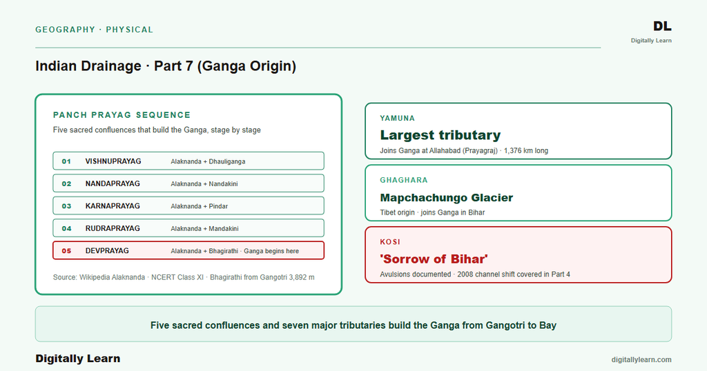
The Panch Prayag are the five most-revered confluences in Hindu river geography. They run along the Alaknanda from north to south, with the Alaknanda picking up a new Himalayan sub-tributary at each stage. The fifth confluence at Devprayag is the formal birthplace of the Ganga as a named river, after which all upstream branches are referred to either as the Bhagirathi or as a tributary of the Alaknanda.
- Vishnuprayag: Alaknanda meets the Dhauliganga; the highest and northernmost Prayag, near the village of Joshimath in Chamoli district.
- Nandaprayag: Alaknanda meets the Nandakini; further south, between Joshimath and Karnaprayag.
- Karnaprayag: Alaknanda meets the Pindar; the Pindar drains the Nanda Devi south face.
- Rudraprayag: Alaknanda meets the Mandakini; the Mandakini comes down from the Kedarnath shrine area.
- Devprayag: Alaknanda meets the Bhagirathi at four hundred and seventy-five metres elevation; downstream of this confluence the river is officially called the Ganga.
Right-Bank Tributaries: Yamuna and Son
The Yamuna from Yamunotri to the Triveni Sangam
The Yamuna is the longest and best-known tributary of the Ganga. The Wikipedia Yamuna article puts the source at the Yamunotri Glacier at six thousand three hundred and eighty-seven metres elevation on the south-western slopes of the Banderpooch peaks in Uttarakhand, with a total length of one thousand three hundred and seventy-six kilometres.
The river flows roughly parallel to the Ganga for hundreds of kilometres across the doab between the Yamuna and the Ganga before turning east and joining at the Triveni Sangam in Prayagraj. The Triveni Sangam is the site of the periodic Kumbh Mela.
The Yamuna receives its own significant tributaries before reaching the Sangam. The Tons rises in the Hari-ki-dun valley and is by volume the largest Yamuna tributary, holding more water than the main Yamuna stream at the point of merger near Dehradun. The Chambal rises in the Vindhya Range and runs nine hundred and sixty kilometres through Madhya Pradesh and Rajasthan before joining near Etawah.
The Betwa originates in Bhopal district and joins near Hamirpur. The Ken runs four hundred and twenty-seven kilometres from the Vindhya Range and joins near Chilla. The Chambal-Betwa-Ken sub-system gives the Yamuna its peninsular character, since these tributaries drain the older Peninsular plateau rather than the young Himalayan front.
The Son from Amarkantak to the Bihar Plain
The Son river is the second major right-bank tributary of the Ganga. It rises on the Amarkantak plateau in the Maikal range of Madhya Pradesh, the same uplift that gives birth to the Narmada (covered in Part 2 of this series as the standard example of radial drainage). The Son runs seven hundred and eighty-four kilometres per the Wikipedia Son article, north-east across Madhya Pradesh, Chhattisgarh, Jharkhand, and Bihar, and joins the Ganga at Maner in Patna district, Bihar.
Its own left tributaries include the Ghaghar, the Johilla, and the North Koel; the right tributaries include the Rihand and the Kanhar. The Son is the only major right-bank Ganga tributary east of the Yamuna and contributes a substantial Peninsular sediment load to the Ganga below Patna.
Left-Bank Tributaries: Ramganga, Gomati, Ghaghara, Gandak, and Kosi
Five Himalayan Left-Bank Tributaries Joining the Ganga in Sequence
The five left-bank tributaries all rise on the Himalayan front and join the Ganga in a west-to-east sequence as the river runs across Uttar Pradesh and Bihar. Each is a substantial river in its own right, and their combined discharge contributes a far larger share of the Ganga's total flow than the right-bank Yamuna-and-Son pair.
- Ramganga: Rises in the Doodhatoli range of Pauri Garhwal at about three thousand metres; runs five hundred and ninety-six kilometres through Uttarakhand and Uttar Pradesh; joins the Ganga near Kannauj.
- Gomati: Rises at Gomat Taal in Pilibhit, Uttar Pradesh, at about two hundred metres elevation; runs about nine hundred kilometres entirely within Uttar Pradesh; joins the Ganga near Saidpur in Ghazipur district.
- Ghaghara: Rises at the Mapchachungo Glacier in Tibet at about three thousand nine hundred and sixty-two metres; runs one thousand and eighty kilometres before joining the Ganga downstream of Chhapra; known as the Karnali in Nepal where it is the longest river at five hundred and seven kilometres; the Ghaghara is the largest Ganga tributary by volume at about two thousand nine hundred and ninety cubic metres per second average discharge per the Wikipedia Ghaghara article.
- Gandak: Rises at the Nhubine Himal Glacier in the Mustang region of Nepal at six thousand two hundred and sixty-eight metres; runs eight hundred and fourteen kilometres; is also called the Kali Gandaki; below Gaindakot the river is called Sapt Gandaki for its seven tributaries Daraudi, Seti, Madi, Marsyandi, Budhi Gandaki, Trishuli, and the main Kali Gandaki; joins the Ganga at Sonpur near Patna.
- Kosi: Rises in the Sapt Kosi confluence of seven streams in eastern Nepal; runs seven hundred and twenty-nine kilometres before joining the Ganga at Kursela in Katihar district; carries the heavy sediment load and lateral channel migration covered in Parts 4 and 5 of this series; known as the Sorrow of Bihar for the twenty-one thousand square kilometres of agricultural land its annual floods affect.
Namami Gange and the Contemporary Health of the Ganga System
Namami Gange Structure: National Ganga Council, NMCG, and the Four Operational Pillars
The Namami Gange programme was launched in 2014 as an integrated mission to rejuvenate the Ganga and its principal tributaries. The mission operates through the National Mission for Clean Ganga as the executive arm and the National Ganga Council (formerly the National Ganga River Basin Authority) as the policy body.
The Council is chaired by the Prime Minister, with the relevant Chief Ministers as members. The 2016 UPSC Prelims tested precisely this structure, confirming that the river basin is the unit of planning and that the body spearheads conservation at the national level.
The operational portfolio of Namami Gange covers four functional areas, set out below.
- Sewerage infrastructure: sewage treatment plants in major basin cities such as Varanasi, Allahabad, Kanpur, and Patna.
- Industrial effluent control: common effluent treatment plants in tannery clusters such as Kanpur.
- Ghat and riverfront development: crematoria modernisation to reduce direct ash discharge into the river.
- Afforestation and biodiversity: conservation planting along the riparian zone.
Independent reviews have produced mixed verdicts on the programme's progress. Structural reasons behind the mixed results of preceding cleanup schemes such as the Ganga Action Plan Phase I and Phase II include inadequate sewage capacity in growth cities, weak enforcement against industrial effluent in cottage industries, the difficulty of regulating diffuse non-point pollution from agricultural runoff, and climate-driven flow regime changes that reduce the river's self-purification capacity.
The Ganga basin sits at the intersection of three forward-looking pressures. Climate change is shifting the snow-glacier feed of the Bhagirathi and the Alaknanda, with downstream implications for dry-season flow. Inland navigation on the National Waterway 1 from Prayagraj to Haldia requires a navigable channel through the Bihar plain and depends on the same sediment-management arithmetic as flood control.
Trans-boundary cooperation with Bangladesh under the Ganga Waters Treaty of 1996 governs the lower reach below Farakka. Parts 8 and 9 of this series take up the Ganga delta and cultural geography, and the Brahmaputra basin, where similar pressures play out on different geographies.
Prelims MCQ practice
Each question below tests one specific concept on the topic. Click to reveal the answer and a full option-wise explanation.
Q1. Consider the following statements about the headwater geometry of the Ganga:
- The Bhagirathi rises at the Gangotri glacier at Gaumukh and is the source stream in Hindu tradition.
- The Alaknanda rises at the Satopanth and Bhagirath Kharak glaciers and is the source stream in hydrology because of its greater length and discharge.
- The Ganga is formally named at the Devprayag confluence of the Bhagirathi and the Alaknanda.
Which of the statements given above are correct?
- 1 only
- 1 and 2 only
- 2 and 3 only
- 1, 2 and 3
Show answer and explanation
Answer: 1, 2 and 3
Explanation.
All three statements match the Wikipedia primary articles on the Bhagirathi and the Alaknanda. The Bhagirathi is the Hindu-traditional source from Gangotri; the Alaknanda is the hydrological source from Satopanth and Bhagirath Kharak glaciers; the Ganga is formally named at the Devprayag confluence.
Q2. Consider the following statements about the Panch Prayag confluences in their order from north to south:
- Vishnuprayag is the meeting of the Alaknanda and the Dhauliganga.
- Karnaprayag is the meeting of the Alaknanda and the Pindar.
- Rudraprayag is the meeting of the Alaknanda and the Bhagirathi.
Which of the statements given above are correct?
- 1 only
- 1 and 2 only
- 2 and 3 only
- 1, 2 and 3
Show answer and explanation
Answer: 1 and 2 only
Explanation.
Statements 1 and 2 match the Wikipedia Alaknanda article. Statement 3 is incorrect: Rudraprayag is the Alaknanda-Mandakini confluence; the Alaknanda-Bhagirathi confluence is Devprayag (the fifth and last Prayag), not Rudraprayag.
Q3. Consider the following statements about the Yamuna and its tributaries:
- The Yamuna rises at the Yamunotri Glacier on the south-western slopes of the Banderpooch peaks.
- The Chambal rises in the Vindhya Range and is a major tributary of the Yamuna.
- The Tons is by volume the largest tributary of the Yamuna and holds more water than the Yamuna at the point of merger.
Which of the statements given above are correct?
- 1 only
- 1 and 2 only
- 2 and 3 only
- 1, 2 and 3
Show answer and explanation
Answer: 1, 2 and 3
Explanation.
All three statements match the Wikipedia Yamuna article: Yamunotri Glacier source on Banderpooch peaks, Chambal as a major Vindhyan tributary, and Tons as the largest Yamuna tributary by volume.
Q4. Consider the following statements about the Ghaghara river:
- The Ghaghara is known as the Karnali in Nepal and is the longest river in Nepal.
- The Ghaghara is the largest tributary of the Ganga by discharge volume.
- The Ghaghara rises at the Yamunotri Glacier in Uttarakhand.
Which of the statements given above are correct?
- 1 only
- 1 and 2 only
- 2 and 3 only
- 1, 2 and 3
Show answer and explanation
Answer: 1 and 2 only
Explanation.
Statements 1 and 2 match the Wikipedia Ghaghara article. Statement 3 is incorrect: the Ghaghara rises at the Mapchachungo Glacier in Tibet near Lake Manasarovar, not at the Yamunotri Glacier.
Q5. Consider the following statements about the Namami Gange programme:
- The National Ganga Council, which sets policy for the Namami Gange programme, is chaired by the Prime Minister.
- The National Mission for Clean Ganga is the executive arm of the Namami Gange programme.
- The Namami Gange operational portfolio covers sewerage infrastructure, industrial effluent control, ghat development, and afforestation.
Which of the statements given above are correct?
- 1 only
- 1 and 2 only
- 2 and 3 only
- 1, 2 and 3
Show answer and explanation
Answer: 1, 2 and 3
Explanation.
All three statements are consistent with the Namami Gange administrative architecture: NGC chaired by the PM, NMCG as the executive arm, four operational pillars covering sewerage, industrial effluent, ghat upgrades, and afforestation.
Sources
- India Physical Environment, Class 11, Chapter 3: Drainage System
- Bhagirathi River
- Alaknanda River
- Yamuna
- Ghaghara River
- Gandaki River
- Son River
- Ganges
- Namami Gange programme overview
- Ganga basin annual reports
- National Mission for Sustaining the Himalayan Ecosystem
- Namami Gange official press releases
Disclaimer
This article synthesises NCERT and the Wikipedia primary articles on the Bhagirathi, the Alaknanda, the Yamuna, the Ghaghara, the Gandaki, the Son, and the Ganges. The numerical claims on source elevation, length, and discharge are cited from those primary sources. Readers seeking the operational details of the Namami Gange programme should consult the National Mission for Clean Ganga website.


