
Overview
Previous Year UPSC-CSE Questions By the end you will be able to draft model answers for the following UPSC questions. Each question carries a collapsible framework showing how to approach it in the exam.
- Prelims 2013The Narmada river flows to the west, while most other large peninsular rivers flow to the east. Why?
- It occupies a linear rift valley.
- It flows between the Vindhyas and the Satpuras.
- The land slopes to the west from Central India. Select the correct answer using the codes given below:
How to approach this Prelims question
Approach: Verify each cause. Statement 1 (linear rift valley) is the structural reason and is TRUE. Statement 2 (flows between Vindhyas and Satpuras) describes Narmada specifically but ALSO applies to other rivers occupying the same trough; the answer key treats this as not the explanatory cause for westward flow per se. Statement 3 (land slopes west from Central India) is FALSE: the peninsular slope is east-southeast. Only Statement 1 explains why Narmada flows west.
Trap to watch: Statement 2 sounds correct as geographic description but does not by itself explain WHY the river flows west. The exam treats the rift-valley structural cause (Statement 1) as the only explanatory reason.
Key facts to recall:
- Narmada and Tapi are the two great west-flowing peninsular rivers
- Both occupy linear rift valleys bounded by parallel fault scarps
- Vindhyas north of Narmada; Satpuras between Narmada and Tapi
- Indian Peninsula slopes east-southeast; westward flow is structural override
Answer signal: (a) 1 only
- Prelims 2023Consider the following statements:
- Amarkantak Hills are at the confluence of Vindhya and Sahyadri Ranges.
- Biligirirangan Hills constitute the easternmost part of Satpura Range.
- Seshachalam Hills constitute the southernmost part of Western Ghats.
How many of the statements given above are correct?
How to approach this Prelims question
Approach: Validate each statement. Statement 1: Amarkantak Hills are at the confluence of Vindhya and Satpura (NOT Sahyadri) ranges; FALSE. Statement 2: Biligirirangan (BR) Hills are in Karnataka at the Eastern-Western Ghats junction, NOT part of Satpura Range; FALSE. Statement 3: Seshachalam Hills are in Andhra Pradesh and part of the Eastern Ghats, NOT Western Ghats; FALSE. All three statements are wrong.
Trap to watch: Each statement swaps the correct mountain range with a plausible-sounding alternative. Sahyadri is the southern Western Ghats name (not associated with Amarkantak). Satpura is the Madhya Pradesh range (not BR Hills). Western Ghats vs Eastern Ghats confusion is exploited for Seshachalam.
Key facts to recall:
- Amarkantak: junction of Vindhya and Satpura ranges (eastern Madhya Pradesh)
- Biligirirangan (BR) Hills: Karnataka, Eastern-Western Ghats junction
- Seshachalam Hills: Eastern Ghats in Andhra Pradesh (Tirumala Tirupati region)
- Sahyadri is the southern Western Ghats name; not at Amarkantak
Answer signal: (d) None
- Prelims 2015Consider the following rivers:
- Vamsadhara
- Indravati
- Pranahita
- Pennar
Which of the above are tributaries of Godavari?
How to approach this Prelims question
Approach: Validate each river. Vamsadhara: INDEPENDENT east-flowing river of Odisha-AP (not Godavari tributary). Indravati: Godavari tributary, drains Bastar plateau of Chhattisgarh. Pranahita: Godavari tributary, formed by Wainganga and Wardha confluence. Pennar: INDEPENDENT east-flowing river of AP (not Godavari tributary). Only Indravati and Pranahita are Godavari tributaries.
Trap to watch: Vamsadhara and Pennar are paired with east-flowing major rivers (both reach Bay of Bengal) but are NOT Godavari tributaries.
Key facts to recall:
- Godavari tributaries (major): Pravara, Manjira, Indravati, Sabari, Pranahita, Wainganga, Wardha
- Vamsadhara: independent east-flowing river, source in Odisha, enters Bay of Bengal at Kalingapatnam
- Pennar: independent east-flowing river of Andhra Pradesh, source in Karnataka
- Godavari forms classic dendritic drainage across the Deccan
Answer signal: (d) 2 and 3 only
- UPSC Mains 2013 GS-IBring out the causes for more frequent landslides in the Himalayas than in the Western Ghats.
How to structure the answer in the exam
Introduction: Open with the geomorphic-age contrast: Himalayas as actively uplifting young fold mountains versus Western Ghats as a more stable older escarpment.
Conclusion: Close with the combined tectonic-plus-monsoon trigger as the key differentiator that makes Himalayan landslides more frequent than Western Ghats events.
What is a Drainage Pattern: Geometry as Geological Signal
Drainage Pattern as the Geometric Arrangement of Streams
A drainage pattern is the geometric arrangement that streams and tributaries adopt across a landscape, viewed in plan from above. The pattern emerges from the way a river network responds to the rocks, slopes, and structures beneath it. Geomorphologists recognise seven canonical patterns, each diagnostic of a particular underlying geological condition. The pattern is therefore not decorative; it is a readable map of the bedrock and tectonic history of the basin.
Why it matters: Drainage pattern is the cheapest and fastest geological reconnaissance tool available. A trained eye reading a topographic sheet or a satellite image can infer the rock type, the structural grain of folds, faults, and joints, and the tectonic history of a region from the network shape alone.
The pattern explains why the Narmada flows west when most peninsular rivers flow east. It explains why streams off the Amarkantak plateau radiate outward, and why the rivers of the Western Ghats run in tight parallel lines to the Arabian Sea. Pattern is the bridge between geomorphology and tectonics.
What is the significance of pattern recognition in drainage geomorphology? Pattern recognition supports four operational tasks. First, it guides geological mapping: a trellis pattern flags folded sedimentary rocks, while a rectangular pattern flags jointed crystalline terrain. Second, it informs groundwater exploration: dendritic patterns on flat alluvium suggest porous aquifers, while rectangular patterns indicate fracture-controlled flow.
Third, pattern reading supports landslide and hazard mapping: parallel high-gradient streams on the Western Ghats signal rapid run-off and slope-failure risk. Fourth, it underpins remote-sensing interpretation: the Indian Space Research Organisation uses drainage texture, through its Bhuvan portal and geological products, to classify terrain at landscape scale.
The Seven Canonical Drainage Patterns Defined
Dendritic and Trellis Patterns: The Two Most Common
(i) The dendritic pattern is the tree-branch network of streams on uniform rock and gentle slope. The name derives from the Greek dendron, meaning tree, and the visual impression is exactly that. A main trunk channel takes smaller tributaries at acute angles, just as twigs join a branch and branches join a trunk.
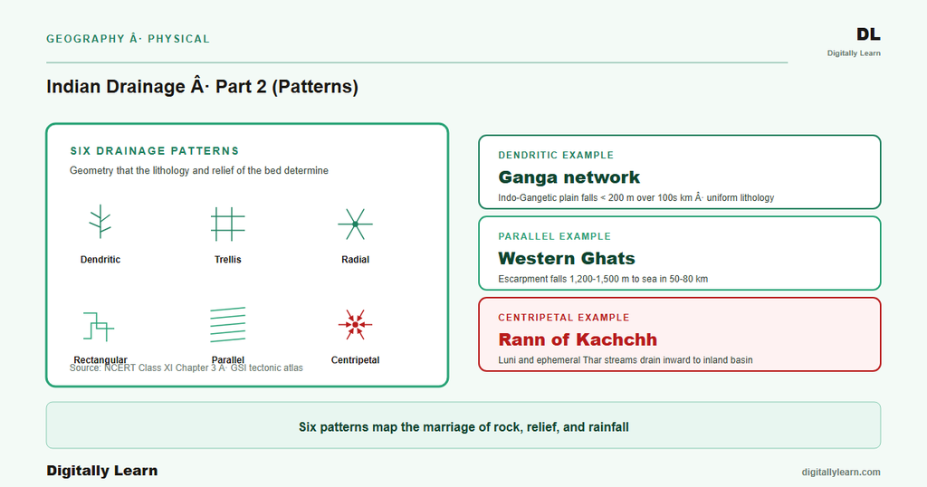
The dendritic pattern develops where the bedrock offers uniform resistance to erosion. The streams then take the path of steepest descent without being deflected by structural weaknesses. The Ganga across the plains and the broad Godavari network across the Deccan both display dendritic geometry.
(ii) The trellis pattern is the right-angle lattice of parallel main streams joined by short perpendicular tributaries. Trellis geometry develops where folded sedimentary rocks expose alternating hard and soft strata. Main streams flow along the soft, eroded synclinal valleys, and short tributaries cross the hard anticlinal ridges at right angles to enter the main channel.
The trellis pattern is the geomorphic fingerprint of folded mountain belts. Indian examples occur among the Lesser Himalayan tributaries of the Ganga, and in some lower Western Ghats sections where alternate ridges and valleys persist.
Radial and Rectangular Patterns: Domes and Joints
(iii) The radial pattern is streams flowing outward in all directions from a central high point. The pattern develops on volcanic cones, structural domes, and isolated peaks. The classical Indian example is the Amarkantak plateau in eastern Madhya Pradesh, where the Narmada flows west to the Arabian Sea while the Son flows east-northeast to the Ganga, radiating from the same dome. Other radial settings in India include Mount Girnar in Gujarat and the rivers off the Nilgiri hills.
(iv) The rectangular pattern is streams that meet at right angles, with frequent abrupt bends. Rectangular geometry develops where the bedrock is cut by two sets of joints or faults intersecting at right angles. Streams exploit these structural weaknesses, with main channels running along one joint set and tributaries along the perpendicular set.
The rectangular pattern is common over jointed crystalline rocks, such as the granitic terrains of the Vindhyan and Aravalli regions. The Colorado Plateau of the United States is the textbook global case; Indian instances are smaller but visible across parts of central India.
Parallel Drainage: The Short West-Flowing Western Ghats Rivers
(v) The parallel pattern is streams that run side by side in straight lines down a single uniform slope. Parallel geometry develops on long uniform slopes where the gradient is too steep for tributary branching. The short west-flowing rivers of the Western Ghats, descending the steep escarpment to the Arabian Sea, form the most striking Indian example.
Rivers such as the Mandovi, the Sharavati, the Periyar, and the Netravati all run in tight parallel courses. Parallel patterns also appear on the western face of the Eastern Ghats and on the monoclinal foothill slopes of the Lesser Himalayas.
Centripetal and Annular Drainage: Inward Basins and Eroded Domes
(vi) The centripetal pattern is streams converging inward from all directions into a central basin or depression. The pattern is the inverse of radial geometry. Instead of flowing outward from a high point, streams flow inward toward a low point. India's classic centripetal example is the Loktak Lake basin in Manipur, where the surrounding hill streams all converge into the lake.
Other centripetal cases include the Lonar crater in Maharashtra. The closed basins of the inland drainage of Rajasthan also qualify, where the Luni and its tributaries converge toward the Rann of Kachchh.
(vii) The annular pattern is streams that flow in concentric rings around an eroded structural dome. Annular geometry develops when erosion strips a dome unevenly, exposing alternating concentric bands of hard and soft rock. The streams follow the soft circular bands, while short radial tributaries cross the hard ones.
The annular pattern is rare. Pure Indian examples are confined to partly-dissected domes along parts of the Vindhyan and Cuddapah basin margins. The pattern is more textbook than common, yet it remains diagnostic wherever it does appear.
Comparison Table: All Seven Patterns at a Glance
| Pattern | Geometric form | Geological control | Indian example |
|---|---|---|---|
| Dendritic | Tree-branch network, acute joining angles | Uniform rock resistance, gentle slope | Ganga across plains, lower Godavari |
| Trellis | Right-angle lattice, parallel main and perpendicular tributaries | Folded sedimentary rocks (anticline-syncline pairs) | Lesser Himalayan tributaries |
| Radial | Outward flow from a central high point | Volcanic cone or structural dome | Amarkantak (Narmada west, Son east); Mount Girnar |
| Rectangular | Right-angle joins, abrupt bends | Two joint sets in crystalline rock | Jointed terrains of Vindhyan, Aravalli regions |
| Parallel | Side-by-side straight courses | Long uniform steep slope | Western Ghats westward rivers (Sharavati, Periyar, Mandovi) |
| Centripetal | Inward convergence to a central basin | Closed depression or inland basin | Loktak Lake (Manipur); Lonar crater; Luni system |
| Annular | Concentric rings around a dome | Eroded dome with alternating hard-soft strata | Vindhyan and Cuddapah basin margins (partial) |
Reading Drainage Patterns on the Indian Map: Five Worked Cases
Amarkantak Radial and Narmada Trellis-Rift Pattern
(a) The Amarkantak plateau of Madhya Pradesh is the textbook radial-drainage centre in India. The Narmada rises from the Narmada Kund at Amarkantak and flows west across the Narmada rift valley. The Son rises nearby and flows east-northeast to join the Ganga near Patna. Two major rivers therefore diverge outward from a single highland source, the hallmark of a radial drainage centre.
The third river often linked to this highland tract is the Mahanadi, which rises further south near Sihawa in Dhamtari district of Chhattisgarh, not at Amarkantak itself. It flows south-east toward the Bay of Bengal. The wider Maikal-Amarkantak uplift therefore feeds rivers to three different seas and slopes.
(b) The Narmada's westward course is the most celebrated structural-control case in Indian drainage. Most peninsular rivers flow east toward the Bay of Bengal because the Indian Peninsula slopes east-southeast. The Narmada and the Tapi are the great exceptions, since both flow west toward the Arabian Sea.
The reason is structural. Both rivers occupy linear rift valleys bounded by parallel fault scarps: the Vindhyan range lies north of the Narmada and the Satpura range lies between the two rivers. The rift geometry forces westward flow regardless of the regional slope. The course is essentially a long, fault-controlled subsequent stream.
Western Ghats Parallel and Loktak Centripetal Patterns
(c) The Western Ghats western face hosts the cleanest parallel drainage in India. The escarpment falls from crestline elevations around 1,200-1,500 metres to sea level over a horizontal distance of only 50-80 kilometres. The steep uniform slope leaves no room for tributary networks to develop, so dozens of short rivers run in tight parallel courses to the Arabian Sea.
The Sharavati, which feeds the Jog Falls, along with the Mandovi, the Periyar, the Bharathapuzha, and the Netravati, are textbook parallel-pattern rivers. Each is short, swift, and incises a steep gradient over its full length.
(d) The Loktak Lake basin of Manipur is India's clearest centripetal drainage example. Loktak is the largest freshwater lake in the northeast, fed by streams from the surrounding hills that converge inward from all directions. The lake itself drains south through the Manipur River into the Chindwin and ultimately the Irrawaddy.
The centripetal geometry persists upstream of the lake. The Lonar crater lake in Buldhana district of Maharashtra, formed by a meteor impact on the Deccan basalt and now a Ramsar site, hosts a similar centripetal micro-drainage on a much smaller scale.
Pattern Analysis in Indian Remote Sensing, Groundwater and River Planning
Where Drainage Pattern Knowledge Lands in Modern Practice
Contemporary linkages: Drainage pattern recognition is now a routine tool in Indian remote-sensing and hydrology practice. The National Remote Sensing Centre at Hyderabad, an ISRO unit, releases standard drainage texture layers from Cartosat and Resourcesat imagery for the entire country.
The Central Ground Water Board uses pattern analysis to delineate fracture zones for borewell siting in hard-rock terrain. The National Mission for Clean Ganga applies basin morphometry, which builds on pattern classification, to plan sediment-management interventions.
Subsequent parts of this series develop these threads. Part 3 examines the factors that produce each pattern, namely geology, relief, climate, and tectonics. Part 4 then traces how Indian drainage evolved through Himalayan uplift, river capture, and antecedent or superimposed drainage.
Prelims MCQ practice
Each question below tests one specific concept on the topic. Click to reveal the answer and a full option-wise explanation.
Q1. Consider the following statements about drainage patterns:
- Dendritic pattern develops on uniform rock with gentle slope and produces a tree-branch network.
- Trellis pattern develops on folded sedimentary rocks where main streams flow along synclines and tributaries cross anticlines at right angles.
- Radial pattern develops on closed inland basins where streams converge inward to a central depression.
Which of the statements given above are correct?
- 1 and 2 only
- 2 and 3 only
- 1 and 3 only
- 1, 2 and 3
Show answer and explanation
Answer: 1 and 2 only
Explanation.
Correct: a (1 and 2 only). Statement 1 is correct: dendritic = tree-branch on uniform rock. Statement 2 is correct: trellis = right-angle lattice on folded sedimentary rocks. Statement 3 is wrong: that description is of the CENTRIPETAL pattern, not radial. Radial = streams flowing OUTWARD from a central HIGH point (volcanic cone or dome); centripetal = streams converging INWARD into a central LOW point.
Q2. Consider the following statements about the Amarkantak plateau:
- The Narmada river rises at Amarkantak and flows west to the Arabian Sea.
- The Son river rises near Amarkantak and flows east-northeast to join the Ganga.
- The Mahanadi river rises at Amarkantak alongside the Narmada and Son.
Which of the statements given above are correct?
- 1 and 2 only
- 2 and 3 only
- 1 and 3 only
- 1, 2 and 3
Show answer and explanation
Answer: 1 and 2 only
Explanation.
Correct: a (1 and 2 only). Statement 1 is correct: the Narmada rises from the Narmada Kund at Amarkantak and flows west. Statement 2 is correct: the Son rises near Amarkantak and flows east-northeast to the Ganga near Patna. Statement 3 is wrong: the Mahanadi rises separately near Sihawa in Dhamtari district, Chhattisgarh, on the wider Maikal uplift, not at Amarkantak. The Narmada and Son are the two rivers that genuinely diverge from the Amarkantak highland.
Q3. Consider the following statements about the westward flow of the Narmada and Tapi rivers:
- Both rivers occupy linear rift valleys bounded by parallel fault scarps.
- Both rivers flow east toward the Bay of Bengal like other major peninsular rivers.
Which of the statements given above is/are correct?
- 1 only
- 2 only
- Both 1 and 2
- Neither 1 nor 2
Show answer and explanation
Answer: 1 only
Explanation.
Correct: a (1 only). Statement 1 is correct: both Narmada and Tapi occupy linear rift valleys, with the Vindhyas to the north of the Narmada, the Satpuras between Narmada and Tapi, and the Western Ghats extension to the south of the Tapi. Statement 2 is REVERSED: both Narmada and Tapi flow WEST (to the Arabian Sea), not east; they are the great exceptions to the eastward peninsular pattern.
Q4. Consider the following statements about the short west-flowing rivers of the Western Ghats:
- These rivers form a classic parallel drainage pattern due to the long uniform steep slope of the western escarpment.
- Examples include the Sharavati (Jog Falls), Mandovi, Periyar, and Netravati.
Which of the statements given above is/are correct?
- 1 only
- 2 only
- Both 1 and 2
- Neither 1 nor 2
Show answer and explanation
Answer: Both 1 and 2
Explanation.
Correct: c (Both 1 and 2). Both statements are correct. The Western Ghats western face falls from ~1,200-1,500 m crestline to sea level over 50-80 km horizontal distance; this uniform steep slope produces parallel-pattern drainage. The named rivers (Sharavati hosting Jog Falls, Mandovi in Goa, Periyar in Kerala, Netravati in Karnataka) all run in tight parallel courses.
Q5. Consider the following statements about centripetal drainage in India:
- Loktak Lake in Manipur is the canonical Indian example of centripetal drainage, with surrounding hill streams converging into the lake.
- Lonar crater lake in Maharashtra hosts a small centripetal drainage formed by a Pleistocene meteor impact on Deccan basalt.
Which of the statements given above is/are correct?
- 1 only
- 2 only
- Both 1 and 2
- Neither 1 nor 2
Show answer and explanation
Answer: Both 1 and 2
Explanation.
Correct: c (Both 1 and 2). Both statements are correct. Loktak is the largest freshwater lake of the northeast and the textbook Indian centripetal example. Lonar crater (Buldhana district, Maharashtra) is a Pleistocene meteor-impact crater on Deccan basalt with its own micro-centripetal drainage and is a Ramsar wetland site.
Q6. Consider the following statements about the Godavari river system, which forms a textbook dendritic pattern across the Deccan:
- The Indravati and Pranahita are tributaries of the Godavari.
- The Vamsadhara is a tributary of the Godavari.
- The Pennar is a tributary of the Godavari.
Which of the statements given above is/are correct?
- 1 only
- 1 and 2 only
- 2 and 3 only
- 1, 2 and 3
Show answer and explanation
Answer: 1 only
Explanation.
Correct: a (1 only). Statement 1 is correct: Indravati and Pranahita are major Godavari tributaries that drain the Bastar and Wainganga basins. Statement 2 is wrong: Vamsadhara is an INDEPENDENT east-flowing river that rises in Odisha and enters Bay of Bengal near Kalingapatnam in Andhra Pradesh, not a Godavari tributary. Statement 3 is wrong: Pennar is also an independent east-flowing river of Andhra Pradesh.
Sources
- NCERT Class 11 India Physical Environment, Chapter 3 (Drainage System), pp 27-37
- Geological Survey of India: tectonic atlas and Amarkantak geoheritage
- Central Water Commission (CWC) basin morphometry
- Central Ground Water Board (CGWB) hard-rock aquifer mapping
- National Remote Sensing Centre (ISRO) Bhuvan portal
- National Institute of Hydrology (NIH), Roorkee
- National Mission for Clean Ganga (Namami Gange) basin sediment programme
- India Water Resources Information System (India-WRIS)
- Wikipedia: Drainage system (geomorphology)
- Wikipedia: Narmada River
Disclaimer
This article is a study aid grounded in NCERT and the official sources cited. Pattern classifications follow the standard geomorphological convention; readers cross-checking specific Indian examples should consult Geological Survey of India publications for precise structural boundaries.


