

Overview
Soil orders are the top level of USDA soil taxonomy, the system that sorts the world's soils into 12 orders by properties that show how each soil formed. The global distribution of soils follows climate, vegetation and landform. Cold lands carry Gelisols and Spodosols, grasslands carry Mollisols, deserts carry Aridisols and the wet tropics carry Oxisols.
Soil Formation and the Soil Profile
Soil-Forming Factors: Passive and Active Controls
Five factors control the formation of soil, namely parent material, topography, climate, biological activity and time. They act together, and each changes how the others work. Soil formation, called pedogenesis, begins with weathering, because the weathered mantle is the raw material from which soil is built. Bacteria, mosses and lichens colonise the weathered debris first, and their dead remains add humus. Grasses, ferns, bushes and trees follow, and plant roots and burrowing animals make the mass porous and sponge-like until a mature soil forms.
The factors fall into two groups. Parent material, topography and time are passive controls: They supply the material, set how water drains and allow the processes to run, but they do not act on the soil themselves. Climate and biological activity are the active controls that do the work.
- Parent material: Residual soils form from rock weathered in place and transported soils form from deposits carried in by water, wind or ice. Young soils show strong links with their parent rock, and in limestone areas the link stays clear.
- Topography: Soils are thin on steep slopes and thick over flat uplands. On gentle slopes erosion is slow and water percolates well, so soil formation is very favourable.
- Climate: Moisture and temperature decide the rate of chemical and biological activity. Heavy rain moves soil components downward (eluviation) and deposits them lower down (illuviation). Where rain is very heavy, even most of the silica leaves the soil, which is called desilication. In dry climates evaporation exceeds precipitation, groundwater rises by capillary action, and the salts left behind form a crust called a hardpan.
- Biological activity: Dead plants provide humus, and bacteria fix nitrogen; Rhizobium in the root nodules of leguminous plants is the standard example. Ants, termites, earthworms and rodents rework the soil up and down.
- Time factor: Soils from recent alluvium or glacial till are young and show no horizons or only poorly developed ones. No absolute length of time can be fixed for a soil to mature.
Temperature works in two directions. Chemical activity rises in heat, falls in cold and stops in freezing conditions, so tropical soils show deeper profiles while the soils of the frozen tundra hold largely mechanically broken material.
Soil Profile and Horizons: O, A, E, B, C and R
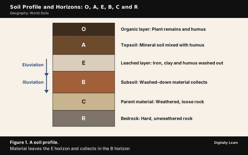
A soil profile is the vertical section from the surface down to the unaltered rock, and a soil horizon is one layer in it that differs from the layers above and below in colour, texture and chemistry. Horizons are the result of soil-forming processes; a layer that has not undergone them is simply called a layer. Horizons are also what most classification systems use to define soil types.
Most soils show some or all of six horizons, each marked by a letter.
| Horizon | What it is |
|---|---|
| O | Organic surface layer of plant remains and humus, found in many soils |
| A | Mineral soil at the surface, mixed with organic matter, usually dark |
| E | Leaching layer that has lost iron, aluminium, clay or organic matter by downward movement |
| B | Well-developed subsoil where material washed down from above accumulates |
| C | Loose, poorly developed parent material below the subsoil |
| R | Hard bedrock |
The E horizon and the B horizon are partners. Eluviation strips material out of E and illuviation deposits it in B. Not every soil has all six; young soils lack developed horizons, and soils that have been deeply ploughed or disturbed by earth-moving may lack them almost completely. Different countries use different horizon symbols, so a letter has meaning only inside its own system.
World Soil Types: Why Soils Follow Climate
Global Distribution of Soils: The Zonal Idea
Soils follow climate because soil forms from weathered rock under the work of water, heat and living things. Soil adjusts to the climate, landform and vegetation around it and changes internally when these change, which is why each great belt of climate carries its own typical soil.
The idea began on the steppes. In 1883 Vasily Dokuchaev studied the steppe soils of the Poltava region, noticed that peasants named soils by colour, and published Russian Chernozem. His work turned soil into a product of climate, vegetation, relief, parent material and time, and he is regarded as the father of soil science. Many Russian words he used, such as chernozem, podzol, gley and solonetz, became part of the international vocabulary of soil science.
Three contrasts show the work of climate.
- Wet tropics: Bacteria act fast and dead vegetation is oxidised quickly, so humus stays low while the profile is deep.
- Cold climates: Bacteria grow slowly, humus accumulates, and peat develops in sub-arctic and tundra climates.
- Dry climates: Evaporation exceeds precipitation, and salts left behind form hardpans.
| Climate and vegetation | Typical zonal soil (USDA order) |
|---|---|
| Tundra with permafrost | Tundra soils (Gelisols) |
| Cool coniferous forest | Podzols (Spodosols) |
| Mid-latitude grassland | Chernozem (Mollisols) |
| Hot desert | Desert soils (Aridisols) |
| Humid tropical forest | Ferralsols, laterites (Oxisols) |
Zonal, Intrazonal and Azonal Soils: The Genetic Classification
The older genetic classification of 1938 sorted soils into three groups by the factor that dominates their formation, which is climate, a local factor, or too little time. It remains in use because it explains why soils do not follow climate everywhere.
| Group | What controls it |
|---|---|
| Zonal soils | Climate and vegetation of a belt; mature profiles |
| Intrazonal soils | A local factor of relief or parent material overrides climate |
| Azonal soils | Too young to develop a profile; mountain slopes, new alluvium |
Intrazonal soils have more or less well-defined profiles that reflect a dominant local factor, and they split into three kinds.
- Calcimorphic soils: These develop on limestone. Rendzinas are thin soils with limited water-holding capacity; terra rossa soils are deep red and go with higher rainfall than rendzinas.
- Hydromorphic soils: These form in wetland conditions. Gley soils form where the pore spaces between grains stay saturated with water and hold no air; the lack of oxygen reduces the iron and gives a grey or blue colour with red flecks. Peat soils form where the vegetation cannot break down completely.
- Halomorphic soils: These form through salinisation.
Azonal soils are those where the parent material keeps moving or arriving. On Himalayan slopes weathered material keeps sliding down, so the time needed for soil formation never becomes available. On flood plains new alluvium arrives every year, so soils stay immature.
The 12 Soil Orders of USDA Soil Taxonomy
What Is a Soil Order? The USDA Soil Taxonomy
A soil order is the highest level of USDA soil taxonomy, which was developed by the United States Department of Agriculture and the National Cooperative Soil Survey. The system has six levels, which run from the most general to the most specific as order, suborder, great group, subgroup, family and series. It classifies by properties that can be measured, such as depth, moisture, temperature, texture, structure, organic matter and salt content, and every order name ends in -sol. The 12 orders of soil reflect major differences in how soils formed.
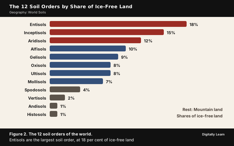
| Soil order | Meaning | Share of ice-free land (per cent) |
|---|---|---|
| Entisols | Recent soils, no developed horizons | 18 |
| Inceptisols | Young soils, some subsurface horizons | 15 |
| Aridisols | Dry desert soils | 12 |
| Alfisols | Clay-rich forest soils with aluminium and iron | 10 |
| Gelisols | Permafrost soils | 9 |
| Oxisols | Deeply weathered tropical soils | 8 |
| Ultisols | Acid, leached humid soils | 8 |
| Mollisols | Dark, soft grassland soils | 7 |
| Spodosols | Acid soils of cool forests | 4 |
| Vertisols | Swelling, cracking clays | 2 |
| Andisols | Volcanic ash soils | 1 |
| Histosols | Organic peat soils | 1 |
The twelve shares add up to 95 per cent, not 100, because the rest of the ice-free land is mostly mountain land, where the orders are mixed or no soil has formed. Published estimates differ by a few points, but in every one Entisols are the largest order.
The orders can also be read as stages of development. In order of increasing development they run Entisols, Inceptisols, Aridisols, Mollisols, Alfisols, Spodosols, Ultisols and Oxisols, while Histosols and Vertisols can appear at any stage. The sequence leaves out Gelisols and Andisols, which are defined by permafrost and by volcanic ash rather than by their stage of development.
Soil Orders of Cold and Wet Lands: Gelisols, Histosols and Spodosols
In the far north, cold and frost shape the soils, and waterlogging preserves plant remains in the wet lowlands. Three orders dominate these lands.
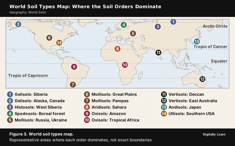
- Gelisols: Soils with permafrost within two metres of the surface, churned by freezing and thawing; they are found in the permafrost lands of Siberia, northern Canada, Alaska and Greenland. Organic matter gathers in the top layer, so most are black or dark brown, yet nutrients such as calcium and potassium leach easily above the frozen layer, so they are not very fertile.
- Histosols: Organic soils, formerly called bog soils, formed where waterlogging stops plant remains from decaying; most lie in Canada, Scandinavia, the West Siberian Plain, Sumatra, Borneo and New Guinea.
- Spodosols (podzols): Acid soils of coniferous and boreal forests, where acids leach iron and aluminium down from an ash‑grey upper layer, usually on quartz-rich sands.
The name podzol is Russian for under-ash soil. Peasants ploughing virgin ground turned up a pale, ash‑like leached layer, the E horizon, low in iron, aluminium and humus. The iron and aluminium washed out of that layer collect below it, which is why a podzol shows the E and B horizons so sharply.
The largest single tropical peatland in the world lies in the Cuvette Centrale of the Congo Basin, mainly in the Democratic Republic of the Congo. Peat is the material of Histosols, plant remains that waterlogging has kept from decaying. By country, Indonesia holds more tropical peatland and mangrove forest than any other, with peat in Kalimantan and Sumatra. Histosols and Gelisols store large quantities of organic carbon, which is why the peat lands matter for the climate.
Soil Orders of Grasslands and Deserts: Mollisols, Aridisols and Vertisols
The drier interiors of continents carry soils that keep their nutrients because little water washes through them. Grass roots add organic matter; desert heat adds salts.
- Mollisols: Deep, dark, fertile soils with a thick organic-rich top layer, the mollic epipedon, built by grass roots; they are typical of the North American Great Plains and Central Asia.
- Aridisols: Dry desert soils with fewer than 90 consecutive moist days in the growing season, little organic matter and layers of caliche or duripan; they dominate the deserts and dry shrublands.
- Vertisols: Clay-rich soils that swell when wet and crack deeply when dry; major areas include eastern Australia, the Deccan Plateau of India and parts of Sudan, Ethiopia and Chad.
India's black soils of the Deccan belong to the Vertisols, and the arid soils of the dry west fall among the Aridisols.
Soil Orders of Forests and the Tropics: Alfisols, Ultisols and Oxisols
Where rain and warmth last long enough, weathering runs deep and leaching strips out bases. Three orders show the sequence from moderately to extremely weathered.
- Alfisols: Clay-enriched forest soils with enough moisture and warmth for at least three months of plant growth; they are found in the Ohio basin, western Europe, European Russia and the drier parts of Peninsular India.
- Ultisols: Acid, highly weathered soils of humid temperate and tropical regions, poor in calcium, magnesium and potassium; they include the red clays of the southern United States. Their red and yellow colours come from iron oxide that has accumulated.
- Oxisols: The most weathered soils, rich in iron and aluminium oxides but low in silica, best known in tropical rain forest within 25 degrees north and south of the equator, and found almost exclusively in tropical areas of South America and Africa.
The richest forests on land stand on some of the poorest soils. Rain passing through the litter on the forest floor is acidified and leaches minerals from the upper layers, and in the heat bacteria oxidise dead vegetation so fast that little humus is left. The forest keeps its nutrients in living plants, so clearing it leaves bare, poor ground. The same intense leaching under tropical rain forms India's laterite soils.
Young and Volcanic Soil Orders: Entisols, Inceptisols and Andisols
The largest orders are the least developed. Entisols and Inceptisols together cover a large part of the world's ice-free land, because so much land is young, steep, sandy or freshly deposited.
- Entisols: Recently formed soils without developed horizons, common on river and beach sediments and volcanic ash; some are only an A horizon on bedrock.
- Inceptisols: Young soils with some subsurface horizon but little eluviation and illuviation; common in rocky or mountainous areas and on river, coastal and marine sediments, but not in deserts or permafrost.
- Andisols: Young volcanic ash soils, usually very fertile, about 1 per cent of ice-free land, mostly around the Pacific Ring of Fire in Chile, Ecuador, Japan, Java and New Zealand; wet rice on Java's Andisols supports some of the densest populations in the world.
World Soil Types Map: Soil Zones Belt by Belt
Tundra Soils and Permafrost: Fragile but Economically Important
Tundra soils sit on permafrost. In the Arctic tundra the ground is permanently frozen below a depth of 25 to 90 cm, which stops trees from growing; in summer only the top layer thaws, and because water cannot sink through the frozen ground it forms marshes, lakes and bogs.
- A carbon store: Tundra soils hold large amounts of biomass stored in the permafrost, making them a carbon sink; warming thaws them and releases greenhouse gases, which feeds further warming.
- Fragile ground: Thawing permafrost could change which species survive within decades or centuries, and buildings and roads built on frozen ground are at risk as it thaws.
- Economic value: The Arctic tundra is rich in petroleum, natural gas and uranium; the Yamalo-Nenets region is the centre of Russia's natural gas production, and nomadic reindeer herders such as the Nenets live on the tundra.
Chernozem and Grassland Soils: The World's Breadbaskets
Some of the richest farm soils lie under the mid-latitude grasslands. Chernozem, the black earth, carries a high share of humus, 4 to 16 per cent, stores moisture well and gives high yields. It forms two great belts. The Eurasian steppe belt runs from Ukraine and Russia to Kazakhstan and Mongolia-Manchuria, and the North American belt runs from the Canadian Prairies through the Great Plains of the United States. Chernozem covers about 230 million hectares.
- Why so fertile: Grass roots add organic matter year after year, building the thick dark top layer.
- Why still fragile: Long cropping depletes the humus, so even chernozems need fertiliser.
- In classification: Chernozems are Mollisols in USDA soil taxonomy and a Reference Soil Group of their own in the World Reference Base.
The grassland soils change as the climate dries. Kastanozems, the chestnut soils, are lighter in colour than chernozems and are related to the Mollisols; they are rich in humus and carry a characteristic brown surface layer, and they are found in relatively dry zones with 200 to 450 mm of rain a year. Beyond them, in still drier country, lie the desert soils, the Aridisols.
Loess: Soil Built from Wind-Blown Silt
Loess is a pale yellow, silt-sized sediment formed by the accumulation of wind-blown dust, and about 10 per cent of the Earth's land area is covered by loess or similar deposits. Loess is made of angular grains of quartz, feldspar and mica, usually with 20 per cent or less clay, and it is often loosely cemented by calcium carbonate. Deposits can be more than a hundred metres thick in north-western China and tens of metres thick in parts of the Midwestern United States.
Because its grains are angular and loosely held, loess stands in steep vertical banks for years and is easy to dig, which is why cave dwellings are cut into it. For the same reason it erodes quickly once its plant cover is stripped. Loess is a parent material rather than a soil order, so the soils that develop on it can belong to many orders. It shows that wind can build land as well as strip it.
World Soil Classification: USDA Orders and the FAO World Reference Base
FAO World Reference Base: 32 Reference Soil Groups
The World Reference Base for Soil Resources is the international system for naming soils and making the legends of soil maps. Its current fourth edition, of 2022, is edited by a working group of the International Union of Soil Sciences, and its first level has 32 Reference Soil Groups. A second level adds qualifiers, 202 in total, so that a soil name carries more detail. The WRB replaced the FAO/UNESCO legend of the Soil Map of the World as the international standard and borrows from Soil Taxonomy, the FAO legend and French and Russian concepts.
The two systems overlap but do not match one to one: USDA uses measured properties to define orders, while the WRB names groups that suit a world soil map.
| USDA soil order | Main WRB groups |
|---|---|
| Gelisols | Cryosols |
| Spodosols | Podzols |
| Oxisols | Ferralsols |
| Aridisols | Calcisols, Gypsisols, Durisols, Solonchaks |
| Mollisols | Chernozems and other dark-topsoil groups |
| Histosols | Histosols |
| Vertisols | Vertisols |
The WRB arranges its 32 groups by what dominates each soil.
- Thick organic layers: Histosols.
- Strong human influence: Anthrosols and Technosols.
- Permafrost and limits to root growth: Cryosols, Leptosols, Solonetz, Vertisols and Solonchaks.
- Iron and aluminium chemistry: Gleysols, Andosols, Podzols, Plinthosols, Planosols, Stagnosols, Nitisols and Ferralsols.
- Pronounced accumulation of organic matter in the topsoil: Chernozems, Kastanozems, Phaeozems and Umbrisols.
- Accumulation of salts and carbonates: Durisols, Gypsisols and Calcisols.
- Clay-enriched subsoil: Retisols, Acrisols, Lixisols, Alisols and Luvisols.
- Little profile development: Cambisols, Fluvisols, Arenosols and Regosols.
Soil Degradation and Conservation
What Is Soil Degradation? Erosion, Salinisation and Loss of Fertility
Soil degradation is the loss of topsoil by erosion and the loss of fertility through over-use, acidification, salinisation or chemical contamination. It is serious because soil is renewed only very slowly. It can take up to 1,000 years to produce just 2 to 3 cm of soil, and 95 per cent of the world's food comes from soil. About 33 per cent of the Earth's soils are already degraded, and over 90 per cent could become degraded by 2050. Erosion can cut crop yields by up to 50 per cent, and land degradation and erosion together threaten the well-being of at least 3.2 billion people.
Erosion is a natural process, but human activity has made it roughly 28 times faster than the natural rate. Intensive agriculture, deforestation, roads, acid rain, climate change and urban sprawl are among the chief human causes. The processes of soil formation and erosion go on together and are normally in balance; the balance breaks when deforestation, over-grazing, construction and mining strip the cover.
Water Erosion and Wind Erosion: Causes and Stages
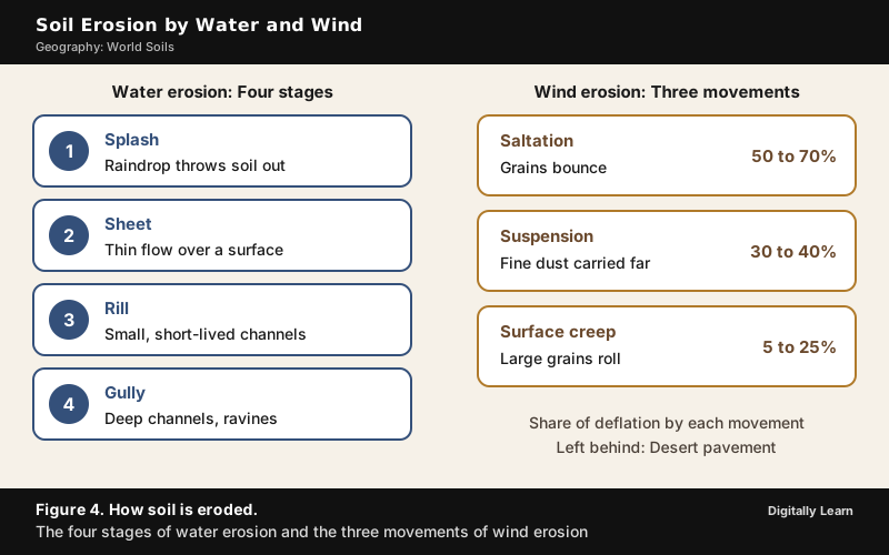
Water erosion proceeds in four stages, each more severe than the one before.
- Splash erosion: A falling raindrop makes a small crater and throws soil particles out; this is the first and least severe stage.
- Sheet erosion: Water flowing over a broad surface carries the loosened particles away.
- Rill erosion: The flow concentrates into small, short-lived channels.
- Gully erosion: Runoff gathers into narrow channels and removes soil to a considerable depth, as in the ravines of the Chambal basin.
Wind erosion works by deflation, the lifting and removal of loose fine particles, and by abrasion, the wearing action of wind-driven grains. Deflation works through three mechanisms. In surface creep larger grains roll or slide, in saltation particles bounce across the surface, and in suspension fine particles travel long distances. Saltation likely accounts for 50 to 70 per cent of deflation, suspension for 30 to 40 per cent and creep for 5 to 25 per cent. Where deflation removes the fine particles and leaves a sheet of rock fragments, the surface is called desert pavement, as in the stony regs of the Sahara.
The Dust Bowl of the 1930s shows what bare soil and wind can do. In the semi-arid High Plains, where less than 510 mm of rain falls a year, farmers had deep-ploughed the virgin topsoil and displaced the deep-rooted native grasses that held soil and moisture. When drought came in three waves, in 1934, 1936 and 1939‑40, the unanchored soil turned to dust and the wind carried it away in huge clouds.
Salinisation and Waterlogging: Soil Damaged by Irrigation
Soil salinisation is the build-up of salts in the soil, and it is caused by natural processes such as mineral weathering and by human ones such as irrigation. Salts accumulate near the surface when water evaporates faster than rain can flush them out, so the soil of dry regions is naturally salty, and irrigation can add to the load because almost all irrigation water contains some salt. Proper irrigation management supplies enough drainage water to leach the added salts away; where drainage is disrupted, salts accumulate.
In drylands, salinity can also rise from below. When the water table stands within two to three metres of the surface in clayey soils, capillary action lifts salts from the groundwater to the surface. Clearing trees for farming is a major cause of the rising water table, because more rainwater then enters the aquifer. The Aswan High Dam in Egypt, built in 1970, is the standard example of disturbed drainage. After its construction the groundwater level stayed continuously high and the arable land became salinised.
When sodium predominates, the soil becomes sodic, as in many of the saline and alkaline soils of India. Sodic soils have very poor structure, which limits or prevents water infiltration and drainage. Gypsum is the most common compound used to reclaim sodic soil, and salt-tolerant plants such as halophytes help as well.
Desertification: Land Degradation in Drylands
Desertification is the gradual degradation of fertile land into arid desert through a combination of natural processes and human activities. The United Nations Convention to Combat Desertification (UNCCD) defines it as "land degradation in arid, semi-arid and dry sub-humid regions resulting from various factors, including climatic variations and human activities." The immediate cause is the loss of most vegetation, driven by drought, climatic shifts, tillage for agriculture, overgrazing and deforestation for fuel or construction materials. Unprotected dry soil surfaces blow away with the wind or are washed away by flash floods, leaving infertile lower layers that bake in the sun and become an unproductive hardpan.
The older idea that desertification means the physical expansion of deserts has been rejected; the process is the degradation of the land itself. Drylands occupy about 40 to 41 per cent of the Earth's land area and are home to more than 2 billion people, at least 90 per cent of whom live in developing countries. The areas most affected are the Sahel in Africa, the Gobi Desert and Mongolia in Asia, and parts of South America. Effects include sand and dust storms, food insecurity and poverty. Mitigation includes improving soil quality, managing grazing, and tree-planting by reforestation and afforestation.
India measures its own position in the Desertification and Land Degradation Atlas of India, published by ISRO's Space Applications Centre at Ahmedabad. About 97.85 million hectares, or 29.77 per cent of the country's geographical area, are affected by land degradation and desertification, and India's drylands extend across around 228 million hectares. The United Nations marks 17 June each year as the World Day to Combat Desertification and Drought.
Soil Conservation: Methods that Work with Slope, Wind and Water
Soil conservation is the prevention of loss of the topmost soil layer by erosion, and of reduced fertility from over-use, acidification, salinisation or chemical contamination. The methods follow the cause of the loss.
- Contour ploughing: Furrows follow the contour lines, which slows the flow of water down the slope; ploughing up and down the slope instead forms channels for quick runoff and erosion. Contour ploughing can raise yields by 10 to 50 per cent, partly because more soil is retained.
- Terracing: Steps cut into a slope make nearly level areas, and terrace cultivation restricts erosion; the western and central Himalayas have well-developed terrace farming.
- Strip cropping: Strips of grass are left to grow between crops, which breaks up the force of the wind.
- Shelter belts and windbreaks: Rows of trees at the windward edge of a field slow the wind; shelter belts have contributed significantly to stabilising sand dunes and the desert in western India.
- Sand fences: Fences of wood or wire make drifting sand settle in a chosen place, helping to stabilise dunes.
- Cover crops and crop rotation: Legumes and other cover crops blanket the soil year-round, act as green manure and replenish nitrogen.
- No-till farming and green manures: These soil-enhancing practices minimise erosion and can revive damaged soil.
Soil Orders in India and the Soil Types of the Subcontinent
Soil Orders in India: Inceptisols to Mollisols
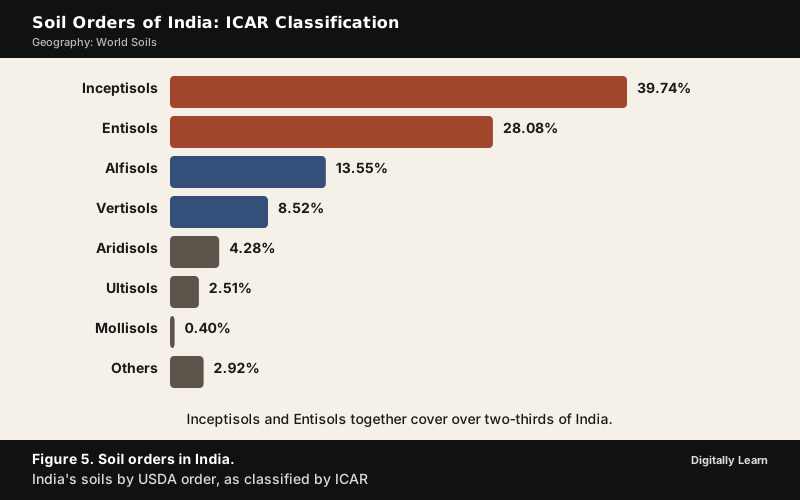
India classifies its soils by the same USDA taxonomy. To study its soils and make them comparable at the international level, the Indian Council of Agricultural Research classified Indian soils into USDA orders, working through the National Bureau of Soil Survey and Land Use Planning.
- Largest: Inceptisols, 39.74 per cent, and Entisols, 28.08 per cent, together over two-thirds of India.
- Next: Alfisols, 13.55 per cent, the forest soils of the drier Peninsula, and Vertisols, 8.52 per cent, the black soils of the Deccan.
- Smaller: Aridisols 4.28, Ultisols 2.51 and Mollisols 0.40 per cent; other soils make up 2.92 per cent.
India's soils are also grouped by genesis, colour, composition and location into alluvial, black, red and yellow, laterite, arid, saline, peaty and forest soils.
Black, Red and Laterite Soils: Parent Rock and Climate
Three Indian soils show a world principle at work, namely that soil follows parent rock and climate.
- Black soil: Also called regur, and known as black cotton soil because it suits cotton. It is typical of the Deccan Trap region, which is made up of lava flows, so the parent rock is basalt. It is very fine and clayey, holds moisture well, is rich in calcium carbonate, magnesium, potash and lime, but is generally poor in phosphoric content. It develops deep cracks in hot weather, which aerate it, and it is sticky when wet.
- Red and yellow soil: It develops on crystalline igneous rocks in areas of low rainfall in the eastern and southern parts of the Deccan plateau. It gets its reddish colour from the diffusion of iron in crystalline and metamorphic rocks, and looks yellow when the iron is in a hydrated form.
- Laterite soil: It develops under a tropical and subtropical climate with alternate wet and dry seasons, as the result of intense leaching by heavy rain. It is deep, acidic and generally deficient in plant nutrients, and it is prone to erosion. Red laterite soils in Tamil Nadu, Andhra Pradesh and Kerala suit cashew nut, and with conservation, tea and coffee grow well on them in the hills.
The Deccan Traps were formed when lava extruded in fissure eruptions around 66 to 65 million years ago, and they cover a very large area, which is why one rock type produces such a wide belt of black soil.
Previous Year UPSC‑CSE Questions
Each Prelims question is explained option by option, and each Mains question comes with an answer outline.
- UPSC Prelims 2024One of the following regions has the world's largest tropical peatland, which holds about three years worth of global carbon emissions from fossil fuels; and the possible destruction of which can exert detrimental effect on the global climate. Which one of the following denotes that region?
How to approach this Prelims question
Approach: The clue is "largest tropical peatland". Peat forms where waterlogging prevents plant remains from decaying, so look for the largest flat, permanently waterlogged tropical basin. Tropical peat is found in the Amazon, the Congo Basin and Southeast Asia, but the single largest tropical peatland is in the Congo Basin.
Trap to watch: The Amazon is the largest rainforest, which tempts (a); the largest tropical peatland is in the Congo Basin.
Why each option is right or wrong:
- (a) Amazon Basin: Wrong. The Amazon has the largest peatland complex of South America (the Pastaza-Maranon basin in the Peruvian Amazon), but the largest tropical peatland in the world is in Africa.
- (b) Congo Basin: Correct. The world's largest tropical peatland lies in the Cuvette Centrale, the flat central basin of the Congo, mainly in the Democratic Republic of the Congo.
- (c) Kikori Basin: Wrong. The Kikori Basin is in Papua New Guinea, which has peat soils, but the world's largest tropical peatland is in the Congo Basin.
- (d) Rio de la Plata Basin: Wrong. It lies in the temperate south of South America, and the largest tropical peatland is in Africa.
Answer: (b) Congo Basin. The world's largest tropical peatland lies in the Cuvette Centrale of the Congo Basin, mainly in the Democratic Republic of the Congo.
- UPSC Prelims 2023Consider the following statements:
- Statement‑I : The soil in tropical rain forests is rich in nutrients.
- Statement‑II : The high temperature and moisture of tropical rain forests cause dead organic matter in the soil to decompose quickly.
Which one of the following is correct in respect of the above statements?
How to approach this Prelims question
Approach: Judge each statement alone first.
- Statement‑I says rainforest soil is rich in nutrients. It is not, because heavy rain leaches minerals, bacteria oxidise dead vegetation quickly, and little humus is left, so the nutrients sit in living plants. Statement‑I is incorrect.
- Statement‑II says high temperature and moisture make dead matter decompose quickly. That is correct.
With I incorrect and II correct, only option (d) fits.
Trap to watch: A dense forest looks like rich soil; the nutrients sit in the plants, not the soil.
Why each option is right or wrong:
- (a) Both Statement‑I and Statement‑II are correct and Statement‑II is the correct explanation for Statement‑I: Wrong. Statement‑I is incorrect, so there is nothing for II to explain.
- (b) Both Statement‑I and Statement‑II are correct and Statement‑II is not the correct explanation for Statement‑I: Wrong. Statement‑I is incorrect, so "both correct" fails.
- (c) Statement‑I is correct but Statement‑II is incorrect: Wrong. This reverses the truth; I is incorrect and II is correct.
- (d) Statement‑I is incorrect but Statement‑II is correct: Correct. Rainforest soil is poor in humus and nutrients, and fast decomposition is exactly why.
Answer: (d) Statement‑I is incorrect but Statement‑II is correct. The soil is poor because decomposition and leaching are fast, so the nutrients are held in the living forest.
- UPSC Prelims 2021The black cotton soil of India has been formed due to the weathering of
How to approach this Prelims question
Approach: Black soil is typical of the Deccan Trap region and is made up of lava flows. The Deccan Traps were built by lava that extruded in fissure eruptions, so the parent rock is fissure volcanic rock, basalt.
Trap to watch: Granite and schist give the red soils; the black soil forms on basalt lava.
Why each option is right or wrong:
- (a) brown forest soil: Wrong. A soil is the product of weathering, not the parent rock of another soil.
- (b) fissure volcanic rock: Correct. The Deccan lava flows from fissure eruptions are the parent rock of black soil.
- (c) granite and schist: Wrong. Crystalline and metamorphic rocks of this kind give the red soils of the eastern and southern Deccan.
- (d) shale and limestone: Wrong. Limestone gives calcimorphic soils such as rendzina and terra rossa, not the black soil of the Deccan.
Answer: (b) fissure volcanic rock. Black cotton soil forms on the basalt of the Deccan Traps, lava erupted through fissures.
- UPSC Prelims 2013Which of the following statements regarding laterite soils of India are correct?
- They are generally red in colour.
- They are rich in nitrogen and potash.
- They are well-developed in Rajasthan and UP.
- Tapioca and cashew nuts grow well on these soils.
Select the correct answer using the codes given below.
How to approach this Prelims question
Approach: Laterite forms by intense leaching under heavy rain in a tropical climate with alternate wet and dry seasons; test each statement against that.
- Statement 1: Laterite is generally red; correct.
- Statement 2: Intense leaching strips out nutrients, so the soil is acidic and poor in nitrogen and potash; wrong.
- Statement 3: It occurs mostly in the southern states, the Western Ghats, Odisha, parts of West Bengal and the north-east, not in dry Rajasthan or Uttar Pradesh; wrong.
- Statement 4: Red laterite suits cashew nut; correct.
Only option (c) has 1 and 4.
Trap to watch: Laterite's deep red colour can look like a sign of rich soil, but intense leaching leaves it poor in nutrients.
Why each option is right or wrong:
- (a) 1, 2 and 3: Wrong. Statements 2 and 3 are false.
- (b) 2, 3 and 4: Wrong. Statements 2 and 3 are false; only 4 is right.
- (c) 1 and 4: Correct. Laterite is generally red (statement 1), and cashew grows well on red laterite (statement 4); with statements 2 and 3 wrong, (c) is the only option left.
- (d) 2 and 3 only: Wrong. Both statements are false, since laterite is nutrient-poor and does not develop in Rajasthan or UP.
Answer: (c) 1 and 4. Laterite is red and leached, and cashew grows well on red laterite.
- UPSC Prelims 2011Salinization occurs when the irrigation water accumulated in the soil evaporates, leaving behind salts and minerals. What are the effects of salinization on the irrigated land?
How to approach this Prelims question
Approach: Salinisation leaves salts behind as water evaporates. Where sodium dominates, the soil becomes sodic and its structure collapses, so water cannot infiltrate or drain. That makes the soil impermeable, which is option (b). Check the others against what salts do. Salts harm crops, they do not raise the water table (a high water table is a cause of salinity, not its effect), and they do not fill the pores with water.
Trap to watch: A high water table causes salinity in drylands; it is not an effect of salinisation.
Why each option is right or wrong:
- (a) It greatly increases the crop production: Wrong. Salt build-up harms plants and cuts productivity; it never raises crop production.
- (b) It makes some soils impermeable: Correct. Sodic soils have very poor structure that limits or prevents water infiltration and drainage.
- (c) It raises the water table: Wrong. A high water table is a cause of salinity in drylands, because capillary action lifts salts from it; it is not an effect of salinisation.
- (d) It fills the air spaces in the soil with water: Wrong. That describes waterlogging, which comes from poor drainage and not from the salts.
Answer: (b) It makes some soils impermeable. Salinisation makes some soils impermeable because sodic soils lose structure and block infiltration and drainage.
- UPSC Prelims 2010With reference to soil conservation, consider the following practices:
- Crop rotation
- Sand fences
- Terracing
- Wind breaks
Which of the above are considered appropriate methods for soil conservation in India?
How to approach this Prelims question
Approach: Test each practice against how it protects soil.
- Crop rotation: It keeps the ground covered and replenishes nitrogen; correct.
- Sand fences: They stop drifting sand and stabilise dunes; correct.
- Terracing: It cuts steps into slopes and restricts water erosion; correct.
- Windbreaks: They slow the wind and so reduce wind erosion; correct.
All four conserve soil.
Trap to watch: Sand fences and windbreaks look like desert-only measures, but they are soil conservation methods too.
Why each option is right or wrong:
- (a) 1, 2 and 3 only: Wrong. It leaves out windbreaks, which are rows of trees that slow wind erosion.
- (b) 2 and 4 only: Wrong. It leaves out crop rotation and terracing, both of which protect the soil.
- (c) 1, 3 and 4 only: Wrong. It leaves out sand fences, which hold drifting sand in place.
- (d) 1, 2, 3 and 4: Correct. Each of the four reduces erosion or loss of fertility.
Answer: (d) 1, 2, 3 and 4. Crop rotation, sand fences, terracing and windbreaks are all soil conservation methods.
- UPSC Prelims 2010When you travel in certain parts of India, you will notice red soil. What is the main reason for this colour?
How to approach this Prelims question
Approach: Red soil forms on crystalline and metamorphic rocks, and its colour comes from iron in those rocks. In humid-tropical soils the red and yellow colours come from accumulated iron oxide, rust. So the cause is iron oxide, not magnesium, humus or phosphate.
Trap to watch: Humus makes soil dark, not red; the red colour is iron oxide.
Why each option is right or wrong:
- (a) Abundance of magnesium: Wrong. Colour comes from iron compounds, not magnesium.
- (b) Accumulated humus: Wrong. Humus makes soil dark, as in chernozem and other Mollisols; the humus-poor weathered tropical soils are the red ones.
- (c) Presence of ferric oxides: Correct. The red colour is iron oxide, the rust of the soil; it looks yellow in a hydrated form.
- (d) Abundance of phosphates: Wrong. Phosphates are nutrients and give no red colour.
Answer: (c) Presence of ferric oxides. Red soil owes its colour to ferric oxide, the iron oxide in the soil.
- UPSC Mains 2026 GS‑I"Tundra regions are ecologically fragile but economically important." Examine this statement critically.
Answer outline
The outline sets out what the question asks, the main arguments, relevant examples and the direction of the conclusion; it is not a full model answer.
Introduction: Tundra lies on permafrost, ground permanently frozen below a depth of 25 to 90 cm, and only the top layer thaws in summer.
Body (sub-themes to develop):
- Fragile: Slow soil formation in cold, a waterlogged summer surface, nutrients that leach easily above the frozen layer, and a carbon store that releases greenhouse gases when it thaws.
- Infrastructure: Buildings and roads on frozen ground are at risk as it thaws.
- Economy: Petroleum, natural gas and uranium; the Yamalo-Nenets region's gas; reindeer herding.
Conclusion: The same permafrost that holds the resources makes extraction risky, so development must be slow and careful.
- UPSC Mains 2026 GS‑IDiscuss the role of aeolian processes in desertification and land degradation.
Answer outline
Introduction: Aeolian processes are the work of wind; in dry, unprotected soil they lift and carry fine particles.
Body (sub-themes to develop):
- Removal: Deflation strips the fine fertile particles through creep, saltation and suspension and leaves desert pavement.
- Land degradation: Topsoil loss, as in the Dust Bowl, cuts fertility and productivity; dust storms are a visible effect.
- Desertification: Loss of vegetation exposes dry soil; wind and flash floods strip it away, and the infertile lower layers bake into an unproductive hardpan.
- Deposition: Wind also builds land, as in the loess deposits.
- Control: Shelter belts, strip cropping and sand fences stabilise dunes and slow the wind.
Conclusion: Wind cannot be stopped, but the vegetation cover that keeps it from lifting soil can be kept.
- UPSC Mains 2020 GS‑IThe process of desertification does not have climatic boundaries. Justify with examples.
Answer outline
Introduction: The UNCCD defines desertification as land degradation in arid, semi-arid and dry sub-humid regions, resulting from climatic variations and human activities.
Body (sub-themes to develop):
- Vegetation loss, whatever the climate: Drought, tillage, overgrazing and deforestation strip the cover, and unprotected dry soil is blown or washed away.
- Examples across regions: The Sahel in Africa, the Gobi Desert and Mongolia in Asia, parts of South America, and the Dust Bowl of the North American High Plains.
- Spread across climates: The UNCCD definition itself spans three climate types, from arid to dry sub-humid, and the drivers are human land use (overgrazing, deforestation, poor irrigation), so degradation follows how land is used rather than one climatic boundary; drylands cover about 40 to 41 per cent of the land and hold over 2 billion people.
Conclusion: Because human land use triggers it, desertification crosses climatic and national boundaries, and so must the response, through grazing management, tree planting and soil improvement.
Sources
- NCERT: Fundamentals of Physical Geography (Class XI), Geomorphic Processes
- NCERT: Contemporary India II (Class X), Resources and Development
- NCERT: India: Physical Environment (Class XI, earlier edition), Soils
- FAO Soils Portal: World Reference Base for Soil Resources
- FAO: World Soil Day
- FAO: Global Symposium on Soil Erosion, key messages
- Wikipedia: USDA soil taxonomy
- Wikipedia: Soil horizon
- Wikipedia: Zonal soil
- Wikipedia: Vasily Dokuchaev
- Wikipedia: Pedogenesis
- Wikipedia: Gelisol
- Wikipedia: Histosol
- Wikipedia: Podzol
- Wikipedia: Mollisol
- Wikipedia: Chernozem
- Wikipedia: Vertisol
- Wikipedia: Oxisol
- Wikipedia: Alfisol
- Wikipedia: Ultisol
- Wikipedia: Aridisol
- Wikipedia: Entisol
- Wikipedia: Inceptisol
- Wikipedia: Andisol
- Wikipedia: Tundra
- Wikipedia: Permafrost
- Wikipedia: Yamalo-Nenets Autonomous Okrug
- Wikipedia: Peat
- Wikipedia: Cuvette Centrale
- Wikipedia: Loess
- Wikipedia: Deccan Traps
- Wikipedia: Soil erosion
- Wikipedia: Wind erosion
- Wikipedia: Dust Bowl
- Wikipedia: Soil salinity
- Wikipedia: Desertification
- Wikipedia: Soil conservation
- Wikipedia: Sand fence
- Wikipedia: World Reference Base for Soil Resources
- Wikipedia: Rendzina
- Wikipedia: Terra rossa
- Wikipedia: Gleysol
- Wikipedia: Kastanozem
- Press Information Bureau: World Day to Combat Desertification and Drought 2026 (17 June 2026)
- Press Information Bureau: Desertification and Land Degradation Atlas of India (17 June 2021)
- United Nations: World Day to Combat Desertification and Drought
- UPSC: Civil Services Examination question papers
Editorial Disclaimer
This article draws on the NCERT geography textbooks, the FAO, the United Nations, the Press Information Bureau and the other works under Sources. Map markers show where an order dominates, not its exact extent.


