

Overview
Theories of monsoon, the burst and the break
The onset of monsoon in India is the arrival of the south-west monsoon over Kerala, normally around 1 June, and the withdrawal of monsoon is its retreat from north-west India, which normally begins around 17 September. Between the two dates lie the burst, the advance across the country and the dry spells called breaks. The thermal, dynamic and jet stream theories of monsoon each explain part of why the winds reverse and why the rains come when they do.
Indian Monsoon: Meaning, Climate and Agriculture
Monsoon Meaning: Seasonal Reversal of Winds and Its Theories
The word monsoon describes a climate in which the direction of the prevailing winds reverses with the season. India has a hot monsoonal climate, and it is the prevalent climate of south and south-east Asia. Despite observations spread over centuries, the monsoon continues to puzzle scientists and no single theory has been able to explain the monsoon fully. A real advance came when the monsoon began to be studied at the global rather than the regional level.
The monsoon has to be understood in two layers. The first is the set of theories that explain why the winds reverse, namely differential heating of land and sea, the seasonal shift of the Inter Tropical Convergence Zone, and the switch of the upper-air jet streams. The second is the yearly cycle that results from them, namely the onset over Kerala, the burst, the advance, the breaks, the withdrawal and the retreating season.
Monsoon Climate: Characteristics and Why It Sustains Agriculture
The monsoon climate has a few defining features. Winds reverse with the season, so the year follows a rhythm of cold weather, hot weather, rainy season and retreating monsoon. For most parts of the country, 70 to 90 per cent of the annual rainfall falls between June and September, and the rain is highly uneven in space. Cherrapunji and Mawsynram in the Khasi Hills receive over 1,080 cm a year, while Jaisalmer rarely gets more than 9 cm. Yet the monsoon gives the country a broad unity of climate, with regional sub-types such as the climates of Kerala, Tamil Nadu, Uttar Pradesh and Bihar.
This pattern shapes economic life directly. The monsoon is the axis around which Indian agriculture revolves: Most farm work is timed by its rains, and farming still employs the largest share of India's workforce.
Except in the Himalayas, temperatures stay above the threshold needed for crops through the year, so rainfall rather than warmth limits farming. Regional variations in the monsoon allow a great variety of crops, but variability of rainfall also brings drought or flood to some part of the country every year, and a sudden burst causes soil erosion over large areas. Nearly half of India's agriculture remains rain-fed, which is why a late onset, a long break or an early withdrawal is felt in farm output and water supply.
Theories of Monsoon: Thermal, Dynamic and Jet Stream
Thermal Theory of Monsoon: Differential Heating of Land and Sea
The thermal theory, also called the differential heating or classical theory, treats the monsoon as a large-scale sea breeze. Towards the end of the nineteenth century it was the accepted explanation. In April and May the sun shines vertically over the Tropic of Cancer, and the large landmass north of the Indian Ocean heats intensely. An intense low pressure forms over the north-western part of the subcontinent. The ocean to the south heats slowly and keeps a higher pressure, so the low-pressure cell on land attracts the south-east trades across the equator.
Moist air flowing from the sea to the heated land rises over the relief of the Indian Peninsula, cools adiabatically and gives orographic rain. This is the south-west monsoon. In winter the land is colder than the sea, the pressure gradient reverses and winds blow out from the high pressure over the north-western land towards the Indian Ocean, from the north-east. This is the north-east monsoon. Because the south-west monsoon flows from sea to land it carries more moisture and gives more rain than the winter wind, which picks up moisture only over the Bay of Bengal and rains over Andhra Pradesh and Tamil Nadu.
The theory explains the reversal of the winds well, and it also explains the role of the Himalayas: The mountain chain traps the monsoon winds and forces them to shed their moisture within the subcontinent. It does not explain the timing or the suddenness of the rains. Many meteorologists hold that the monsoon is not a local phenomenon but a general weather phenomenon along the whole tropical zone. This criticism does not deny differential heating; it makes heating one factor among several.
Dynamic Theory of Monsoon: The Shifting ITCZ
The dynamic theory explains the monsoon through the annual shift of the global belts of pressure and winds. The Inter Tropical Convergence Zone (ITCZ) is the low-pressure zone near the equator where the trade winds converge, so air tends to ascend there. It follows the vertical sun; during the northern summer, in May and June, it moves north towards the Tropic of Cancer. In July the ITCZ is located around 20° N to 25° N over the Gangetic plain, where it is also called the monsoon trough.
With the ITCZ north of the equator, the south-east trade winds of the Southern Hemisphere have to cross the equator to reach it. They cross between 40° E and 60° E longitude. After crossing, the Coriolis force turns them to the right, so they blow from the south-west towards the north-east. The south-west monsoon is therefore a continuation of the south-east trades. In winter the ITCZ moves southward, the winds reverse and the north-east monsoon blows.
The dynamic theory treats the monsoon as a global phenomenon, and it complements the thermal theory rather than replacing it: Together they explain why monsoon rainfall varies in intensity along coasts backed by orographic barriers such as the Western Ghats. The dynamic theory is associated with the German climatologist Hermann Flohn, who from 1950 explained the monsoon as part of the global circulation and wrote on the meteorology of the Tibetan highlands.
The dynamic theory also gives one explanation of the burst. The huge landmass of the Himalayas confines the low-pressure zone to the foothills at first. Only when the Tibetan Plateau heats up significantly more than the Himalayas does the ITCZ shift abruptly and swiftly north, and the monsoon rains burst over the subcontinent.
Jet Stream Theory of Monsoon: Tibetan Heating and the Easterly Jet
The jet stream theory explains the timing of the monsoon through the upper-air currents. Jet streams are narrow belts of fast upper-air winds that develop just below the tropopause over areas of steep pressure gradient. Over India a subtropical westerly jet blows south of the Himalayas in winter. In summer it is replaced over India by the tropical easterly jet, and the intense summer heating of the Tibetan Plateau is believed to be the critical factor in forming that jet. The heated plateau builds a warm anticyclone aloft, the Tibetan High, whose easterly outflow forms the tropical easterly jet.
The westerly jet and the easterly jet do not coexist over the plain. The shift of the ITCZ is related to the withdrawal of the westerly jet from its position south of the Himalayas. The easterly jet sets in along latitude 15° N only after the westerly jet has withdrawn from the north Indian plain, and it is held responsible for the burst of the monsoon.
The suddenness of the burst has a physical reason. As the Tibetan Plateau heats, the low pressure over it pulls the westerly jet northward. The lofty Himalayas inhibit this movement, but pressure keeps dropping and after some time enough force builds for the jet to cross the Himalayas. The shift is therefore abrupt rather than gradual, and the rains burst onto the plains. The reverse shift brings the north-east monsoon.
- Timing: A timely northward shift of the westerly jet at the start of summer brings a timely monsoon; a delayed shift delays it, and an early shift brings an early monsoon.
- Strength: A strong tropical easterly jet over central India goes with a strong south-west monsoon, and a weak jet with a weak monsoon.

Theories of Monsoon Compared: Thermal, Dynamic and Jet Stream
The three theories answer different questions about the same monsoon. The two modern theories also share one idea: The monsoon is part of a planetary circulation, and land heating is only the trigger that places the circulation over India.
| Theory | Central idea | What it explains | Where it falls short |
|---|---|---|---|
| Thermal (classical) | Land heats faster than sea, so a summer low over land draws moist winds inland | Seasonal reversal of winds; orographic rain on the windward side | Treats the monsoon as local; cannot explain the timing or the burst |
| Dynamic | The ITCZ follows the vertical sun north; south-east trades cross the equator and turn south-west | Why the wind is south-westerly; varying intensity along coasts with barriers | Needs the heating of Tibet to explain the abrupt shift |
| Jet stream | Westerly jet leaves the Indian plain and the tropical easterly jet sets in over the south | Date of onset, burst, strength of the monsoon in a year | Depends on the Tibetan heating that triggers the jet shift |
Circulation Systems Behind the Monsoon
Somali Jet, Mascarene High and Offshore Trough
Several circulation systems over the Indian Ocean drive the monsoon. The Mascarene High is a high-pressure area near the Mascarene Islands in the south Indian Ocean during the monsoon period. It is responsible for the cross-equatorial flow through the south Arabian Sea and acts as the southern hemispheric link of the monsoon. Variations in its intensity send surges across the equator, and these surges bring heavy rain along the west coast.
The Somali jet, also called the Findlater jet after the scientist who documented it in 1969, is a low-level cross-equatorial flow, 1 to 1.5 km above sea level. It originates near Mauritius and northern Madagascar, reaches the Kenya coast at about 3° S and runs along the Somali coast to about 9° N. In May it moves from East Africa into the Arabian Sea, it reaches the west coast of India in June, and it attains maximum strength in July. Its short fluctuations of 8 to 10 days matter, because a strengthened jet gives a strong monsoon over peninsular India.
Along the west coast a shallow offshore trough of low pressure forms at sea level during the monsoon, anywhere from north Kerala to south Gujarat, and it strengthens the rainfall in the adjacent coastal belt. When the monsoon winds do not have the energy to climb the Western Ghats, they are deflected around the mountains and the return current forms an offshore vortex, which causes heavy to very heavy rain on the west coast.
Heat Low, Monsoon Trough and Monsoon Depressions
The heat low is a shallow low-pressure area, extending only up to about 850 hPa (1.5 km), over north-west India, Pakistan and the surrounding arid zones. In June the land surface there passes about 160 watts per square metre of heat into the atmosphere. Even when cloud forms over the heat low, the precipitation is very small. An intense heat low acts as a suction device that pulls moist air along the monsoon trough, and a weak heat low, as in the drought year 1987, goes with scanty rain.
The monsoon trough is an elongated low-pressure area from the heat low over Pakistan to the head of the Bay of Bengal. On surface charts it can be traced from Ganganagar to Kolkata through Prayagraj, with westerly and south-westerly winds on its southern side and easterly or south-easterly winds on its northern side. Its position is the single best guide to the weather of a day; it can swing about 5° of latitude north or south within 24 hours, and the synoptic systems that bring rain travel along it.
Monsoon lows intensify into monsoon depressions, the principal rain-bearing systems of the season. These have wind speeds between 17 and 33 knots, and on average two form in each monsoon month, mostly over the Bay of Bengal. Those that form in early June are responsible for the advance of the monsoon. Depressions in the monsoon season seldom grow into cyclonic storms, because the strong wind shear between the lower and upper levels is unfavourable for cyclone formation; this is why India gets cyclones before and after the monsoon rather than in July and August.
| Component | Where | Role in the monsoon |
|---|---|---|
| Mascarene High | South Indian Ocean near the Mascarene Islands | Drives the cross-equatorial flow; surges give heavy west-coast rain |
| Somali jet | 1 to 1.5 km up, from Mauritius and Madagascar along the Somali coast | Carries moisture to the west coast of India in June; strongest in July |
| Heat low | North-west India, Pakistan, West Asia, up to about 1.5 km | Draws moist air along the monsoon trough |
| Monsoon trough | From the heat low over Pakistan to the head of the Bay of Bengal | Marks the axis of rain-bearing systems; its position decides active spells and breaks |
| Tibetan High | Warm anticyclone over the Tibetan Plateau in the middle and upper troposphere | Source of the easterly outflow that forms the tropical easterly jet |
| Tropical easterly jet | About 150 hPa near the latitude of Chennai in July | Its position influences the pattern of rainfall; moves north in break conditions |
Onset of Monsoon: Arrival over Kerala and Advance across India
What Is the Onset of Monsoon? IMD Criteria for Kerala
The onset of monsoon is the arrival of the south-west monsoon, and it is declared first over Kerala. The India Meteorological Department (IMD) declares it only when three conditions agree, so that a single shower does not count as the monsoon.
- Rainfall: After 10 May, if 60 per cent of 14 listed stations report 2.5 mm or more of rain for two consecutive days, onset is declared on the second day. The stations are Minicoy, Amini, Thiruvananthapuram, Punalur, Kollam, Alappuzha, Kottayam, Kochi, Thrissur, Kozhikode, Thalassery, Kannur, Kudulu and Mangalore.
- Wind field: Westerlies must be deep, up to 600 hPa, over the area from the equator to 10° N and from 55° E to 80° E. The zonal wind over 5° N to 10° N and 70° E to 80° E must be about 15 to 20 knots at 925 hPa.
- Cloud: Outgoing longwave radiation measured by the INSAT satellite must be below 200 watts per square metre over the area 5° N to 10° N and 70° E to 75° E, a sign of deep cloud.
The Northern Limit of Monsoon is the northernmost limit up to which the monsoon has advanced on a given day. The monsoon usually advances in surges. IMD tracks the limit daily and declares further advance when the rain spreads to new areas and the limit can still be drawn as one continuous line.
Normal Dates of Onset: Kerala on 1 June, All India by 8 July
Under the IMD's new normal dates of 2020, the monsoon sets in over Kerala around 1 June, nearly the same as the old normal, and it covers the entire country by 8 July, one week before the old normal date of 15 July. The new normals use 1961 to 2019 data for onset and 1971 to 2019 data for withdrawal; the old ones came from 1901 to 1940 data and 149 stations.
The advance follows a fixed order, and the normal dates record it.
- 22 May: The Andaman and Nicobar Islands.
- 26 May: The central Bay of Bengal.
- 1 June: Kerala.
- 5 June: Coastal Karnataka, parts of Tamil Nadu and the north-east.
- 10 June: Goa and south Maharashtra.
- 15 June: More of Maharashtra, Telangana, Odisha, West Bengal and Sikkim.
- 20 June: South Gujarat, south Madhya Pradesh and most of Bihar and Jharkhand.
- 30 June: Most of Gujarat, Madhya Pradesh, Uttar Pradesh, Uttarakhand, Ladakh, Jammu and Kashmir, Punjab, Haryana, Delhi and east Rajasthan.
- 8 July: The remaining parts of north-west India.
NCERT gives mid-July for the monsoon to cover the whole subcontinent; the IMD's revised normal of 2020 gives 8 July.
| City | Normal onset (new) | Normal withdrawal (new) |
|---|---|---|
| Kochi | 1 June | After 15 October |
| Bengaluru | 3 June | After 15 October |
| Dibrugarh | 4 June | 14 October |
| Mumbai | 11 June | 8 October |
| Patna | 16 June | 8 October |
| Nagpur | 16 June | 7 October |
| Bhopal | 20 June | 3 October |
| Ahmedabad | 26 June | 28 September |
| Delhi | 27 June | 25 September |
| Jaipur | 29 June | 23 September |
| Bikaner | 6 July | 18 September |
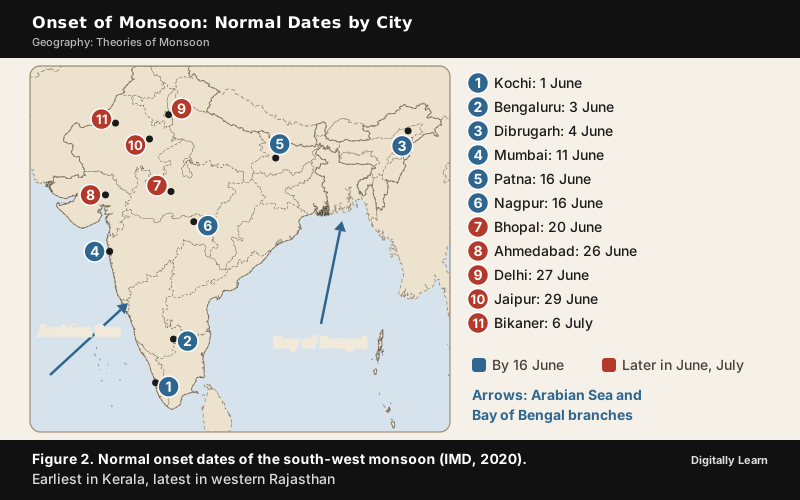
Arabian Sea and Bay of Bengal Branches of the Monsoon
The south-west monsoon approaches India in two branches, whose directions are modified by relief and by the thermal low over north-west India.
The Arabian Sea branch splits into three. One part is obstructed by the Western Ghats and climbs the slopes from 900 to 1,200 m, cools and gives very heavy rain of 250 to 400 cm on the windward side of the Sahyadris and the western coastal plain. It then descends, warms and loses humidity, so the region east of the Ghats is a rain-shadow area.
A second part strikes the coast north of Mumbai and moves along the Narmada and Tapi valleys into central India. A third part strikes Saurashtra and Kachchh, crosses west Rajasthan along the Aravallis with little rain, and joins the Bay of Bengal branch in Punjab and Haryana. The two branches reinforce each other and cause rain in the western Himalayas.
The Bay of Bengal branch strikes the coast of Myanmar, but the Arakan Hills deflect a large part of it towards the subcontinent. It therefore enters West Bengal and Bangladesh from the south and south-east and not from the south-west. Under the influence of the Himalayas and the thermal low of the north-west it splits again; one arm moves west along the Ganga plains as far as the Punjab plains, and the other moves up the Brahmaputra valley, causing widespread rain. A sub-branch strikes the Garo and Khasi Hills, and Mawsynram on the crest of the Khasi Hills receives the highest average annual rainfall in the world.
The Tamil Nadu coast stays dry in this season for two reasons: It lies parallel to the Bay of Bengal branch, and it is in the rain shadow of the Arabian Sea branch.
Purvaiya Winds of the Ganga Plain and Monsoon Culture of Bhojpur
The Bay of Bengal branch explains why the south-west monsoon is called Purvaiya, the easterly wind, in the Bhojpuri region of Uttar Pradesh and Bihar. The branch that moves west along the Ganga plains does not reach Bhojpur as a south-westerly. It arrives from the Bay after turning at the Arakan Hills and the Himalayan front, and the surface winds are easterly or south-easterly over north Bengal and Bihar. The local name, Purvaiya or the easterly, follows that direction.
The rains left a deep mark on the culture of the region. Kajari, a folk and semi-classical song form of the Bhojpuri region, is sung in the rainy season, usually from late June to September, and its theme is a woman's longing for a beloved far away, which the rains sharpen; the crow is often described as the messenger carrying word to the lover in faraway lands. The same theme of separation, migration and poverty runs through Bhikhari Thakur's Bhojpuri play Bidesiya, composed and staged in 1912. In this way the direction and timing of the seasonal wind, which brings farm work back, are written into the songs, festivals and migration stories of the region.
Burst of Monsoon: Why the Rains Arrive Suddenly
The burst of monsoon is the sudden onset of moisture-laden south-west winds with violent thunder and lightning, which raises daily rainfall abruptly and brings down the day temperature by 5 to 8 °C between mid-June and mid-July. The monsoon may burst in the first week of June in coastal Kerala, Karnataka, Goa and Maharashtra, while in the interior it can be delayed to the first week of July. The first rain begins rather abruptly, and its sudden fall is the practical sign that the monsoon has arrived.
Two theories explain why the change is sudden. The jet stream theory says the westerly jet is held back by the Himalayas until enough force builds, and then shifts north swiftly. The dynamic theory says the Himalayas confine the low-pressure zone at first and the ITCZ jumps north when the Tibetan Plateau heats up much more than the Himalayas. Both explanations place the cause in the interaction of Tibetan heating with the mountain barrier. The same mechanism works in reverse for the north-east monsoon, which gives a second, minor burst of rain over the eastern Peninsula in winter.
Break in the Monsoon and Monsoon Variability
Break in the Monsoon: Active and Dry Spells
A break in the monsoon is a spell of one or more weeks without rain after a few days of rain, in the middle of the rainy season. These dry spells are common, and in different regions they have different causes.
- North India: Rain fails when rain-bearing storms are not frequent along the monsoon trough or the ITCZ over the region.
- West coast: Dry spells come on days when the winds blow parallel to the coast.
- Trough position: When the monsoon trough shifts to the foothills of the Himalayas, most of India has a break, while the foothills receive heavy rain and the Brahmaputra and other rivers may flood. A trough south of its normal position gives an active, vigorous monsoon.
- Upper air: In break conditions the tropical easterly jet moves north up to latitude 20° N, and the low-level jet bypasses India and flows near Sri Lanka instead of crossing the peninsula near 15° N.
The break is part of the monsoon rather than its failure, and it shows up clearly in recent seasons. In 2025 a well-defined break spell developed in early August and lasted until mid-August, with the rainfall over central India below its normal by more than one standard deviation on several days.
Intra-seasonal Rhythm: Madden-Julian Oscillation and Other Cycles
Breaks and active spells come in a rhythm, and the rhythm has several periods. The Madden-Julian Oscillation (MJO) is the leading mode of tropical intra-seasonal variability, discovered by Madden and Julian in 1971. It is a massive coupling of deep convection and atmospheric circulation that moves slowly eastward over the Indian and Pacific Oceans, with a cycle of 30 to 60 days. Its life cycle is divided into eight phases of roughly seven to eight days each, depending on where the convection sits, and capturing the MJO in forecast models is crucial for forecasting active spells and breaks.
Other cycles lie on shorter time scales. The synoptic mode has a period of three to seven days and comes from the formation and movement of low-pressure systems over the Indian landmass. The quasi-biweekly oscillation of 14 to 15 days moves westward, with troughs and lows followed by ridges, and an area under a trough gets enhanced rain while an area under a ridge gets suppressed or no rain. A 40-day mode moves the maximum cloud zone from the equator to 30° N.
El Niño, La Niña and the Southern Oscillation
From one year to the next the monsoon is governed mainly by the oceans. El Niño is a complex weather system that recurs every three to seven years, when warm currents appear off the coast of Peru in the eastern Pacific, and it distorts the equatorial atmospheric circulation. The name means 'the Christ child', because the current appears around Christmas. During the strong El Niño of 1990‑91, the onset of the south-west monsoon was delayed by 5 to 12 days over most of the country. IMD defines it by unusually warm sea surface temperatures over the central and eastern equatorial Pacific and defines La Niña by unusually cool temperatures over the same region.
The Southern Oscillation links the Pacific to the Indian monsoon. Gilbert Walker, who became director-general of observatories in India in 1904 and studied the monsoon after the failure of its rains had brought severe famine, discovered the seesaw of pressure. The pressure difference between Tahiti in the South Pacific and Port Darwin in northern Australia is used to predict the strength of the monsoon. The combined phenomenon is called the El Niño-Southern Oscillation (ENSO).
- El Niño years: El Niño generally suppresses the monsoon by weakening the large-scale circulation that carries moisture to India, with below-normal rainfall, more dry spells and heatwaves. Many major droughts, such as 1982, 1987, 2002, 2009 and 2015, occurred during El Niño events.
- La Niña years: La Niña generally strengthens the monsoon circulation and raises the chance of above-normal rain and floods.
- Not deterministic: Not every El Niño brings drought, because other drivers modify its effect.
El Niño and La Niña are natural climate phenomena. Climate change cannot cause El Niño, though warmer oceans and air can amplify its effects through heatwaves and heavy rain. A newer pattern, El Niño Modoki, has its warming in the central Pacific instead of the eastern Pacific, and it is linked to more Atlantic hurricanes that make landfall, whereas the usual El Niño reduces Atlantic hurricane activity.
Indian Ocean Dipole and Other Drivers of Monsoon Variability
The Indian Ocean Dipole (IOD) is a naturally occurring seesaw of sea surface temperature between the western and eastern equatorial Indian Ocean. It was first identified in 1999. It develops in the boreal summer, peaks from September to November and weakens quickly. It is measured by the Dipole Mode Index, the difference between the temperature anomaly of a western area (50° E to 70° E, 10° S to 10° N) and an eastern area (90° E to 110° E, 10° S to the equator); a value of +0.4 °C or more is a positive IOD, and −0.4 °C or less is a negative IOD.
A positive IOD, with a warmer western Indian Ocean and a cooler sea near Indonesia, tends to bring more moisture to India and favours above-normal rain. A negative IOD suppresses convection over India. A positive IOD can therefore partly or substantially offset the drying effect of El Niño, as in 1997, when the Indian monsoon rainfall was normal despite a strong El Niño, and a negative IOD with El Niño raises the chance of a deficient monsoon.
Other drivers act with these two. They include the Madden-Julian Oscillation, Eurasian snow cover, the Atlantic Zonal Mode, the North Atlantic Oscillation and the Arctic Oscillation. IMD monitors all of them for the seasonal outlook, and it uses its Monsoon Mission Coupled Forecasting System to predict ENSO several months ahead. For a season's realised all-India rainfall, the IMD's broad scale counts 90 to 110 per cent of the long period average as normal, below 90 per cent as deficient and above 110 per cent as excess; its seasonal forecasts use five finer categories, with 96 to 104 per cent as normal.
Withdrawal of Monsoon and the Retreating Season
Withdrawal of Monsoon: IMD Criteria for the First Withdrawal
The withdrawal of monsoon starts in the far north-west and moves south and east, in the order opposite to the advance. The IMD does not attempt to declare withdrawal from the extreme north-western parts before 1 September. After that date it considers three synoptic features for the first withdrawal from the western parts of north-west India.
- No rain: Cessation of rainfall over the area for five continuous days.
- Anticyclone: Establishment of an anticyclone in the lower troposphere, at 850 hPa and below.
- Dry air: Considerable reduction of moisture, as seen in satellite water-vapour images and tephigrams.
Further withdrawal is declared when the withdrawn area stays continuous, moisture falls in the water-vapour images and dry weather lasts five days. Withdrawal from the southern Peninsula, and hence from the entire country, is declared only after 1 October, when the circulation changes over from the south-westerly wind regime.
Normal Dates of Withdrawal: From 17 September to 15 October
Under the new normal, the withdrawal of monsoon begins from north-west India around 17 September, a delay of more than two weeks over the old date of 1 September, but it then proceeds much faster. Its normal dates run as follows.
- 20 September: More of Rajasthan, north Gujarat and western Punjab and Haryana.
- 1 October: Most of Gujarat, Rajasthan, Jammu and Kashmir, Ladakh, Punjab, Haryana, Delhi, Himachal Pradesh, Uttarakhand and west Uttar Pradesh.
- 10 October: Most of Maharashtra, east Madhya Pradesh, north Chhattisgarh, east Uttar Pradesh, and most of Bihar and Jharkhand.
- 15 October: Most of the country; the remaining areas follow as the north-east monsoon is established over the south Peninsula.
NCERT places the retreat from western Rajasthan in the first week of September; the IMD's revised normal begins the withdrawal from north-west India around 17 September.
The delay is largest in the far north-west, 11 to 16 days, and it is only 1 to 3 days over most other areas, which is why the end date of 15 October stayed the same.
Retreating Monsoon and the October Heat
The retreating monsoon season covers October and November. By the end of September the south-west monsoon weakens as the low-pressure trough of the Ganga plain begins moving south with the sun. By the beginning of October the low pressure covers the northern Bay of Bengal, by early November it is over Karnataka and Tamil Nadu, and by mid-December the centre of low pressure has left the Peninsula.
The season is marked by clear skies and a rise in temperature. The land is still moist, so high temperature and high humidity make the weather oppressive; this is the 'October heat'. In the second half of October the mercury falls rapidly in northern India. The weather is dry in north India, but the eastern part of the Peninsula gets rain, and October and November are the rainiest months of the year on the Coromandel coast.
This rain comes from cyclonic depressions that originate over the Andaman Sea and cross the east coast of the southern Peninsula. These tropical cyclones are very destructive, and the densely populated deltas of the Godavari, Krishna and Kaveri are among the areas they strike most often. A few cyclonic storms also strike West Bengal, Bangladesh and Myanmar, and cyclones are less frequent in the Arabian Sea. In October and November the north-east monsoon, crossing the Bay of Bengal, picks up moisture and causes torrential rain over the Tamil Nadu coast, southern Andhra Pradesh, south-east Karnataka and south-east Kerala.
The north-east monsoon has its own declaration criteria. The climatological onset date is 22 October, with a standard deviation of about 7 days, and the climatological withdrawal date is 4 January, giving a season of about 75 days. The IMD's criteria include the withdrawal of the south-west monsoon up to 15° N, persistent surface easterlies over the Tamil Nadu coast with depth up to 850 hPa, and fairly widespread rain over coastal Tamil Nadu and south coastal Andhra Pradesh.
Duration of Monsoon: Longest in the South and North-East, Shortest in the North-West
Because the monsoon arrives from the south-west and leaves from the north-west, its duration shrinks towards the north-west. The new normal dates show the pattern. In Mumbai the monsoon stays from 11 June to 8 October, about four months. In Delhi it stays from 27 June to 25 September, about three months, and in Bikaner from 6 July to 18 September, about ten weeks. In the north-east, Dibrugarh has it from 4 June to 14 October, over four months. The Peninsula south of these cities keeps it longest, since withdrawal there waits for the south-westerly regime to change.
Rainfall thins out in the same direction. Rainfall in the northern plains decreases from the east to the west, from 100 to 200 cm in Bihar and the northern Ganga plain along the sub-Himalayas to 50 to 100 cm in western Uttar Pradesh, Delhi, Haryana and Punjab, and below 50 cm in most of western Rajasthan. The far north-west is at the end of both journeys, which gives it the latest onset, the earliest withdrawal and the least rain.

Recent Monsoon Seasons: 2025 and 2026
Onset, Advance and Withdrawal in 2025 and 2026
Two recent seasons show how far an actual year can differ from the normal dates. In 2025 the monsoon reached the Andaman Sea early, set in over Kerala on 24 May, eight days before the normal date and the earliest since 2009, advanced across south India and the north-east by 29 May, and then paused for about 17 days before resuming its progress on 16 June. It still covered the whole country on 27 June. Its withdrawal from north-west India began on 14 September, three days before the normal date. Further withdrawal was later held up for nearly two weeks by a low-pressure system that grew into cyclonic storm Shakti over the Arabian Sea, and the monsoon then withdrew rapidly after 10 October and left the whole country by 16 October.
In 2026 the monsoon set in over Kerala on 4 June, three days late although the IMD had forecast 26 May, and covered the country on 9 July, with advance over Maharashtra, Gujarat, Madhya Pradesh, Chhattisgarh and Odisha delayed by about 7 to 10 days. Withdrawal began from west Rajasthan on 19 September. The season ended deficient, with rainfall at 87 per cent of the long period average. El Niño conditions developed in June and had become moderate by the end of the season, and the Indian Ocean Dipole stayed neutral through the season although a positive IOD had been forecast.
| Feature | Normal (IMD) | 2025 | 2026 |
|---|---|---|---|
| Onset over Kerala | 1 June | 24 May | 4 June |
| Whole country covered | 8 July | 27 June | 9 July |
| Withdrawal begins from north-west India | 17 September | 14 September | 19 September |
| Seasonal rainfall | 868.6 mm (LPA) | 108 per cent of LPA | 87 per cent of LPA |
Previous Year UPSC‑CSE Questions
Each Prelims question is explained option by option, and each Mains question comes with an answer outline.
- UPSC Prelims 2017With reference to 'Indian Ocean Dipole (IOD)', sometimes mentioned in the news while forecasting Indian monsoon, which of the following statements is/are correct?
- IOD phenomenon is characterised by a difference in sea surface temperature between tropical Western Indian Ocean and tropical Eastern Pacific Ocean.
- An IOD phenomenon can influence an El Niño's impact on the monsoon.
Select the correct answer using the code given below:
How to approach this Prelims question
Approach: The IOD is a seesaw within the Indian Ocean, so its second pole is the eastern Indian Ocean, not the Pacific. A positive IOD can offset El Niño's drying effect.
Trap to watch: Statement 1 borrows the eastern Pacific from ENSO.
Why each option is right or wrong:
- (a) 1 only: Wrong. The IOD compares the western and eastern equatorial Indian Ocean; the eastern Pacific belongs to ENSO.
- (b) 2 only: Correct. A positive IOD can partly or substantially offset El Niño, as in 1997, when the monsoon was normal despite a strong El Niño.
- (c) Both 1 and 2: Wrong. Statement 1 names the Pacific.
- (d) Neither 1 nor 2: Wrong. Statement 2 is correct.
Answer: (b) 2 only. The IOD is west against east in the Indian Ocean, and it can modify El Niño's effect.
- UPSC Prelims 2012Consider the following statements:
- The duration of the monsoon decreases from southern India to northern India.
- The amount of annual rainfall in the northern plains of India decreases from east to west.
Which of the statements given above is/are correct?
How to approach this Prelims question
Approach: The monsoon reaches the south early and leaves it last, and reaches the north-west last and leaves it first, so its stay shortens northward. Along the Ganga plain rainfall decreases from Bihar towards Punjab.
Trap to watch: Both statements describe the same south-east to north-west thinning; neither is false.
Why each option is right or wrong:
- (a) 1 only: Wrong. Statement 2 is also correct: Rainfall decreases from 100 to 200 cm in Bihar to 50 to 100 cm in western Uttar Pradesh, Delhi, Haryana and Punjab.
- (b) 2 only: Wrong. Statement 1 is correct too: Mumbai keeps the monsoon about four months, Delhi about three and Bikaner about ten weeks.
- (c) Both 1 and 2: Correct. Both follow from the monsoon thinning out towards the north-west.
- (d) Neither 1 nor 2: Wrong. Both statements are correct.
Answer: (c) Both 1 and 2. The monsoon stays shorter and rain thins out going north-west.
- UPSC Prelims 2011La Nina is suspected to have caused recent floods in Australia. How is La Nina different from El Nino ?
- La Nina is characterised by unusually cold ocean temperature in equatorial Indian Ocean whereas El Nino is characterised by unusually warm ocean temperature in the equatorial Pacific Ocean.
- El Nino has adverse effect on south-west monsoon of India, but La Nina has no effect on monsoon climate.
Which of the statements given above is/are correct ?
How to approach this Prelims question
Approach: Both La Niña and El Niño are conditions of the equatorial Pacific, La Niña cool and El Niño warm. El Niño suppresses the monsoon and La Niña generally strengthens it, so La Niña does have an effect.
Trap to watch: Statement 1 sounds right until the ocean is checked: La Niña is in the Pacific, not the Indian Ocean.
Why each option is right or wrong:
- (a) 1 only: Wrong. La Niña is unusually cool sea surface temperature over the central and eastern equatorial Pacific, not the Indian Ocean.
- (b) 2 only: Wrong. La Niña generally strengthens the monsoon and raises the chance of above-normal rain.
- (c) Both 1 and 2: Wrong. Both statements are incorrect.
- (d) Neither 1 nor 2: Correct. Statement 1 puts La Niña in the wrong ocean and statement 2 denies its effect.
Answer: (d) Neither 1 nor 2. La Niña is a cool Pacific condition that generally strengthens the monsoon.
- UPSC Prelims 2010A new type of El Nino called El Nino Modoki appeared in the news. In this context, consider the following statements:
- Normal El Nino forms in the Central Pacific ocean whereas El Nino Modoki forms in Eastern Pacific ocean.
- Normal El Nino results in diminished hurricanes in the Atlantic ocean but El Nino Modoki results in a greater number of hurricanes with greater frequency.
Which of the statements given above is/are correct?
How to approach this Prelims question
Approach: Fix the places first. The usual El Niño warms the eastern Pacific near Peru; the Modoki type warms the central Pacific. Then the Atlantic effect: The usual El Niño reduces Atlantic hurricane activity, while Modoki is linked to more hurricanes that make landfall.
Trap to watch: Statement 1 swaps the two locations, which is easy to miss.
Why each option is right or wrong:
- (a) 1 only: Wrong. Statement 1 swaps the locations: The usual El Niño is the eastern Pacific type and Modoki the central Pacific.
- (b) 2 only: Correct. The usual El Niño diminishes Atlantic hurricanes and Modoki is linked to more of them.
- (c) Both 1 and 2: Wrong. Statement 1 is incorrect.
- (d) Neither 1 nor 2: Wrong. Statement 2 is correct.
Answer: (b) 2 only. The places are swapped in statement 1; statement 2 is right on hurricanes.
- UPSC Prelims 2002For short-term climate prediction, which one of the following events, detected in the last decade, is associated with occasional weak monsoon rains in the Indian sub-continent?
How to approach this Prelims question
Approach: The question asks for an event that signals a weak monsoon year. El Niño, with the pressure seesaw of the Southern Oscillation, weakens the circulation that carries moisture to India.
Trap to watch: La Niña is the same family of events, but it strengthens the monsoon.
Why each option is right or wrong:
- (a) La Niña: Wrong. La Niña generally strengthens the monsoon circulation and favours above-normal rain.
- (b) Movement of Jet Streams: Wrong. The jets switch every year and decide the date of onset; a late shift delays the monsoon rather than marking a weak year.
- (c) El Niño and Southern Oscillations: Correct. El Niño years usually bring below-normal rainfall, and many major drought years fell in El Niño events.
- (d) Greenhouse effects on global level: Wrong. It is a slow, long-term change, not an event used for short-term prediction.
Answer: (c) El Niño and Southern Oscillations. El Niño with the Southern Oscillation is linked to occasional weak monsoon rain.
- UPSC Prelims 1996High temperature and low pressure over the Indian sub-continent during the summer season, draws air from the Indian Ocean leading to the in-blowing of the
How to approach this Prelims question
Approach: The summer heating of the north-western plains makes a heat low that draws the south-east trades across the equator. After crossing, the Coriolis force turns them to the right, so they blow from the south-west and are called the south-west monsoon.
Trap to watch: The winds start as south-east trades, which tempts (a) or (c); the name follows the direction after the turn.
Why each option is right or wrong:
- (a) Southeast monsoon: Wrong. The trades that cross the equator are south-easterly, but the Coriolis force turns them south-westerly.
- (b) Southwest monsoon: Correct. The winds drawn in from the Indian Ocean by the summer low blow from the south-west.
- (c) Trade winds: Wrong. The south-east trades are the source, but once they cross the equator into the circulation over India they are the south-west monsoon.
- (d) Westerlies: Wrong. The westerly flow over India is the winter jet stream, which leaves the plain before the summer monsoon sets in.
Answer: (b) Southwest monsoon. The heat low draws the south-east trades across the equator and they turn south-west.
- UPSC Mains 2023 GS‑IWhy is the South-West Monsoon called 'Purvaiya' (easterly) in Bhojpur Region? How has this directional seasonal wind system influenced the cultural ethos of the region?
Answer outline
The outline sets out what the question asks, the main arguments, relevant examples and the direction of the conclusion; it is not a full model answer.
Introduction: In the Bhojpuri region the south-west monsoon arrives from the east and is called Purvaiya.
Body (sub-themes to develop):
- Branch: The Bay of Bengal branch is deflected by the Arakan Hills and enters West Bengal and Bangladesh from the south and south-east.
- Turn along the plain: Under the Himalayas and the north-west low, one arm moves west along the Ganga plains, with easterly surface winds over Bihar.
- Songs: Kajari, sung from late June to September, expresses separation from the beloved in faraway lands.
- Migration: Bhikhari Thakur's Bidesiya of 1912 carries the theme of separation and migration.
Conclusion: The direction and timing of the seasonal wind are written into the songs and migration stories of the region.
- UPSC Mains 2017 GS‑IWhat characteristics can be assigned to monsoon climate that succeeds in feeding more than 50 percent of the world population residing in Monsoon Asia?
Answer outline
Introduction: A monsoon climate is one in which the prevailing winds reverse with the season.
Body (sub-themes to develop):
- Seasonal reversal: Land-sea heating and the shift of the ITCZ give a rhythm of four seasons.
- Concentrated rain: 70 to 90 per cent of annual rainfall falls between June and September.
- Unity with diversity: A broad unity of climate with regional sub-types.
- Crop-growing warmth: Except in the Himalayas, temperatures stay above the threshold for crops all year, so rainfall sets the limit.
- Variability: Breaks, El Niño and the IOD bring drought or flood, and rain-fed farms depend on timely rain.
Conclusion: Warmth through the year and a reliable rainy season let the monsoon lands support a large population, at the cost of dependence on the rains.
Sources
- NCERT: India, Physical Environment (Class XI), Chapter 4, Climate
- IMD: New normal dates of onset and withdrawal of the south-west monsoon (2020)
- IMD: ENSO, IOD and their impact on the Indian summer monsoon
- IMD: Onset and withdrawal criteria (north-east monsoon)
- IMD: Frequently asked questions on the monsoon
- IMD: Monsoon 2025, a report
- IMD: Onset and advance of the monsoon
- IMD: Salient features of the 2026 south-west monsoon season
- IMD: Withdrawal of the south-west monsoon
- NOAA PMEL: What is El Nino?
- Wikipedia: Monsoon of South Asia
- Wikipedia: Hermann Flohn
- Wikipedia: Somali Jet
- Wikipedia: Kajari
- Wikipedia: Bidesiya (play)
- Wikipedia: Walker circulation
- Wikipedia: El Niño–Southern Oscillation
- Wikipedia: Indian Ocean Dipole
- UPSC: Civil Services Examination question papers
Editorial Disclaimer
This article uses the current NCERT geography textbook, the India Meteorological Department, the US National Oceanic and Atmospheric Administration and Wikipedia. Onset and withdrawal dates are long-term normals; any single year may be earlier or later.
See more of our UPSC articles in Google Search
Add to Preferred Sources