


Overview
The Gadgil and Kasturirangan reports and the draft ESA notifications
The Western Ghats, an ancient range older than the Himalayas, a UNESCO World Heritage Site and a biodiversity hotspot, are at the centre of a long effort to declare Ecologically Sensitive Areas, weighed between conservation and development.
The Western Ghats are a chain of hills running along the western edge of peninsular India, an ancient range older than the Himalayas that was inscribed as a UNESCO World Heritage Site in 2012 and is recognised as one of the world's biodiversity hotspots. To protect this fragile landscape, the Ministry of Environment, Forest and Climate Change has long sought to declare parts of it an Ecologically Sensitive Area (ESA), in which the most damaging activities would be barred. Two expert reports shaped this effort: the Gadgil panel (the Western Ghats Ecology Expert Panel, 2011), which recommended about 64 percent of the Ghats as sensitive area, and the Kasturirangan High Level Working Group (2013), which scaled this back to about 37 percent. The draft ESA notification, covering six States, has been re-issued repeatedly amid a sharp debate between conservation and development.
What the Western Ghats Are: A World Heritage Hotspot Older Than the Himalayas
An ancient range, a World Heritage Site and a biodiversity hotspot
The Western Ghats are a continuous chain of hills running roughly parallel to India's west coast, from the river Tapi in the north down to the southern tip of the peninsula. They are a geologically ancient range, older than the great Himalayan mountain chain, and their high ridges intercept the south-west monsoon, wringing rain from it and feeding the rivers on which much of peninsular India depends. This role in the monsoon and the water cycle is one reason the range matters far beyond its own borders.
In 2012 the Western Ghats were inscribed as a UNESCO World Heritage Site, a serial property made up of thirty-nine component protected areas spread across the range. The listing recognised the Ghats as a feature of outstanding universal value, both for their geological age and for the exceptional life they hold. The property includes tiger reserves, national parks and wildlife sanctuaries that together protect the heart of this ecosystem.
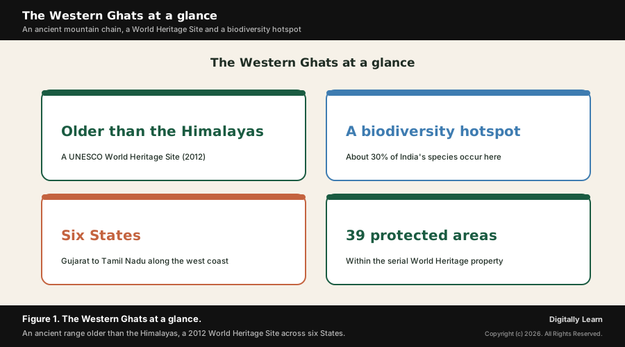
The Western Ghats are also one of the world's biodiversity hotspots, a region of exceptional species richness that is at the same time under serious threat. Roughly thirty percent of all the plant and animal species found in India occur in the Ghats, and a very high share of them are endemic, that is, found nowhere else on Earth. Flagship endemics such as the lion-tailed macaque, the Nilgiri tahr and the Nilgiri langur have become symbols of the range. The figure below gathers the headline facts.
Why the Western Ghats are ecologically fragile and worth protecting
The same features that make the Western Ghats precious also make them fragile. Steep slopes, heavy monsoon rainfall and deep, weathered soils mean that once forest cover is removed, hillsides can fail catastrophically. The range is, in ecological terms, close to the limits of what it can absorb, so unplanned construction, quarrying and the conversion of forest to plantation can tip stretches of it past a threshold beyond which damage is rapid and hard to reverse.
Decades of pressure have steadily eroded the natural cover of the Ghats. Mining, quarrying, large dams, expanding plantations, road building and growing hill-town settlements have fragmented forests and disturbed slopes. Because so much of the range's biodiversity is endemic and concentrated, this loss matters not only locally but for the wider stock of life on the planet, which is precisely why a special protective regime was thought necessary.
Why the Western Ghats Are in the News: A Draft Notification and Renewed Alarm
The latest draft notification and the renewed conservation alarm
Why it matters now is that the long effort to give the Western Ghats a protective Ecologically Sensitive Area status remains unfinished, and recent disasters have sharpened the argument. The Ministry of Environment, Forest and Climate Change has issued a draft ESA notification for the Ghats several times over more than a decade, only for it to lapse and be re-issued again, because the six States and many local communities have resisted parts of it. Each fresh draft restarts the same debate.
The argument was renewed by deadly landslides in the ecologically fragile parts of the range. In July 2024 catastrophic landslides struck Wayanad in Kerala, a district that the Gadgil panel had placed in the most strictly protected zone, killing a very large number of people. Conservationists pointed out that the affected areas had been flagged years earlier as too fragile for heavy disturbance, reviving the question of whether the Ghats are being developed beyond their ecological carrying capacity.
Understanding the Significance of the Eco-Sensitive Area Question
Ecological security, carrying capacity and the development balance
What is the significance of the Western Ghats eco-sensitive area question lies first in ecological security. The Ghats regulate the monsoon, recharge the rivers and store carbon and biodiversity for the whole peninsula, so protecting them is not a local luxury but a foundation of water and food security for hundreds of millions of people downstream. An ESA regime is the instrument meant to keep this foundation intact.
Its second significance is the idea of carrying capacity. An ecosystem can absorb only so much use before it begins to degrade, and the ESA approach is an attempt to keep development within that limit by barring the most damaging activities in the most fragile zones. Read this way, the Western Ghats debate is a concrete test of whether India can plan sustainable development that respects ecological thresholds rather than crossing them.
Its third significance is the hard question of balance. Millions of people live and farm in the Ghats, and protection that ignores their livelihoods will fail politically and on the ground. The genuine challenge is to design a regime that conserves the fragile core while allowing farming, homes and reasonable local development to continue, so that conservation and livelihoods are reconciled rather than set against each other.
The Two Expert Reports: The Gadgil Panel and the Kasturirangan Group
The Gadgil Committee (WGEEP, 2011) and its three-zone approach
The first of the two reports came from the Western Ghats Ecology Expert Panel (WGEEP), chaired by the ecologist Madhav Gadgil and appointed by the Ministry of Environment and Forests. The panel submitted its report in 2011 and took a strongly precautionary view: it recommended that about sixty-four percent of the entire Western Ghats be treated as Ecologically Sensitive Area, because so much of the range is fragile and ecologically valuable.
The Gadgil panel proposed a graded, three-zone system rather than a single blanket rule. It divided the sensitive area into Ecologically Sensitive Zones I, II and III, with the strictest protection in zone I, lighter regulation in the others, and decisions on what to permit taken from the bottom up with a strong role for local gram sabhas. In the most sensitive zones it sought to bar new mining, quarrying, large dams, thermal power and polluting industry.
To run this regime the panel recommended a dedicated statutory body, a Western Ghats Ecology Authority, to oversee conservation across the range and across State boundaries. The Gadgil report was widely praised by ecologists for its rigour, but several State governments and industry groups regarded its coverage as too extensive and its restrictions as too tight, and it was not implemented as written.
The Kasturirangan Committee (HLWG, 2013) and how it differed
In response to that resistance the Ministry set up a High Level Working Group (HLWG) under the space scientist K. Kasturirangan to re-examine the Gadgil report. The HLWG submitted its report in 2013 and took a more balanced stance, aiming to reconcile the Gadgil panel's environmental concerns with the development demands of the six States, and it substantially scaled back the protected extent.
The central difference was one of coverage. Where Gadgil had proposed about sixty-four percent of the Ghats, the Kasturirangan group recommended bringing only about thirty-seven percent under Ecologically Sensitive Area, an area of roughly sixty thousand square kilometres. It did this by distinguishing the relatively undisturbed natural landscape from the cultural landscape of farms, plantations and settlements, and proposing strict protection only for the natural-landscape core.
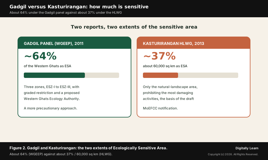
The HLWG also softened the method. Instead of the Gadgil panel's graded zones and a new ecology authority, it proposed a single sensitive area within which a defined list of the most damaging activities, such as mining, quarrying, thermal power and large polluting industry, would be prohibited, while most existing activity continued. This narrower, prohibition-list approach became the basis of the Ministry's draft notification, but it drew criticism from ecologists who felt it conceded too much. The table and figure below contrast the two.
| Feature | Gadgil panel (WGEEP, 2011) | Kasturirangan group (HLWG, 2013) |
|---|---|---|
| Share as sensitive area | About 64 percent | About 37 percent (about 60,000 sq km) |
| Approach | Graded zones, ESZ-I to ESZ-III | Single area with a list of barred activities |
| Landscape view | Most of the range as sensitive | Only the natural landscape protected |
| Proposed body | A Western Ghats Ecology Authority | No new authority of that kind |
| Overall stance | More precautionary | More development-balanced |
Reading the rows together shows the core difference: the Gadgil panel sought wide, graded and locally-decided protection across most of the range, while the Kasturirangan group narrowed protection to the undisturbed natural core and a prohibition list, the form the draft notification eventually took.
What an Eco-Sensitive Area Means and the Activities It Regulates
What an Ecologically Sensitive Area is and what it restricts
An Ecologically Sensitive Area, also called an Ecologically Sensitive Zone or Ecologically Fragile Area, is a region notified by the central government in which especially harmful activities are restricted so as to protect a fragile ecosystem. The aim is not to freeze all human activity but to act as a buffer and a filter, keeping the most destructive land uses out of places that cannot withstand them while ordinary life goes on.
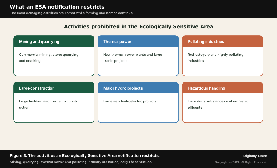
Within such an area the rule is generally regulation, not prohibition. Most everyday activities, farming, horticulture, the running of existing homes and small enterprises, continue, while a defined list of damaging activities is barred or tightly controlled. In the Western Ghats ESA the prohibited list centres on commercial mining, stone quarrying and crushing, new thermal power plants, large hydroelectric projects, red-category polluting industries, the handling of hazardous substances and large-scale construction.
It is important for the exam to be precise about what an ESA does not do. It does not evict residents, ban farming or stop normal village life; its restrictions fall on the heaviest, most polluting and most land-altering projects. Much of the controversy over the Western Ghats notification has arisen from misunderstanding on this point, with fears of blanket bans that the actual draft does not impose. The figure below sets out the restricted activities.
The Institutional and Legal Architecture Behind the Notification
The Environment Protection Act, the Ministry, the States and the experts
The legal foundation of the whole effort is the Environment (Protection) Act, 1986, the umbrella environmental law enacted after the Bhopal disaster. The Act does not use the phrase eco-sensitive zone, but its Section 3 empowers the central government to take all measures it considers necessary to protect the environment, including restricting the areas in which industries, operations or processes may be carried out, and this is the power under which Ecologically Sensitive Areas are notified.
The notifying authority is the Ministry of Environment, Forest and Climate Change (MoEFCC) at the centre. It is the Ministry that appointed both the Gadgil panel and the Kasturirangan group, that issued directions in 2013 barring the most damaging new projects in the sensitive area, and that has drafted and re-drafted the ESA notification. The Ministry also runs schemes and works with research bodies to map and protect the range.
Sound protection depends on good monitoring. The Forest Survey of India, an organisation under the Ministry, carries out a nationwide assessment of forest cover every two years in its India State of Forest Report, and recent reports have treated forest-cover change in the Western Ghats as a contemporary concern. This kind of independent, repeated measurement of how the range's forests are faring is what allows any sensitive-area regime to be checked against reality rather than taken on trust.
Crucially, environment and forests are subjects on which the States have a major stake, and land and local administration are State responsibilities. So although the notification is a central instrument, the Ministry has consulted the six State governments at length, and their objections have repeatedly sent the draft back for revision. Expert committees provide the science, the Ministry holds the legal power, and the States hold much of the ground-level authority, which is why agreement has been so hard to reach.
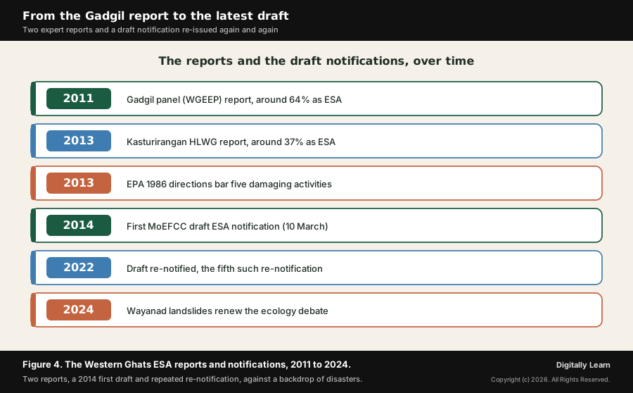
A final layer is the judiciary. Courts, including the Supreme Court and the National Green Tribunal, have at times pressed the government to finalise protection for the Western Ghats and have shaped the wider law on eco-sensitive zones around protected areas. This judicial pressure has kept the issue alive even when the executive and the States were deadlocked, reinforcing that the ESA question is settled through several institutions at once, not one. The timeline below traces how the reports and draft notifications have unfolded.
The Conservation Versus Development Debate, in Measured Terms
State and community concerns set against the conservation case
At the heart of the unfinished notification lies a genuine debate that deserves to be set out fairly on both sides. On one side, the conservation case holds that the Western Ghats are a fragile, globally important ecosystem already under heavy strain, that the science of two expert panels supports strong protection, and that disasters such as the Wayanad landslides show the cost of developing the range beyond its ecological limits. On this view, a firm ESA regime is overdue.
On the other side stand the concerns of the State governments and many residents. Several States have argued that an extensive ESA would constrain mining, power, industry and infrastructure on which their economies and revenues depend, and that decisions about their land and development should rest substantially with them. These are real concerns about livelihoods, growth and federal balance, and they are presented here as the States' considered position, not as obstruction.
There are also direct livelihood worries among the people of the Ghats. Farmers, plantation workers and small settlements have feared that protection would restrict their land use, their construction and their daily activities, fears sharpened by confusion over what the draft actually bars. Much of the local opposition has rested on the belief that an ESA means blanket bans and even eviction, which the notification does not propose, so part of the conflict is one of communication as much as of substance.
A balanced reading holds these together. The disaster-risk argument, that building heavily on fragile, landslide-prone slopes endangers the very communities that protection is said to constrain, suggests the interests of conservation and of local safety often point the same way. The task, on which reasonable people differ, is to draw the sensitive area and its rules so that the fragile core is genuinely protected while farming, homes and proportionate local development are secured, a balance the long re-notification process is still trying to find.
The Way Forward for Protecting the Western Ghats
Participatory demarcation, restoration and credible enforcement
A workable way forward begins with participatory demarcation. Finalising the sensitive area through genuine consultation with the six States and with local gram sabhas, using transparent ecological and ground-truthed data, would build the legitimacy that successive top-down drafts have lacked, and would separate the fragile core that must be protected from the cultural landscape where life continues.
It also calls for active restoration and livelihoods. Protecting the Ghats is not only about barring harmful projects but about restoring degraded forests, stabilising slopes and supporting livelihoods, such as eco-tourism, sustainable farming and payments for ecological services the range provides, so that local communities gain from conservation rather than losing by it. This turns residents into partners in protection.
Finally, credible enforcement and disaster-readiness are essential. Whatever extent is finally notified, it must be backed by honest monitoring, by an end to illegal quarrying and encroachment, and by serious landslide mapping, early-warning systems and land-use planning that keeps heavy construction off the most dangerous slopes. The aim throughout is a settlement that respects the range's ecological carrying capacity while treating the people who live there as partners, not adversaries.
UPSC Relevance and Exam Focus
Where the Western Ghats ESA fits in the UPSC-CSE syllabus
This topic maps most directly to General Studies Paper III: conservation, environmental pollution and degradation, and environmental impact assessment, and to the wider theme of reconciling development with environmental protection. It also connects to disaster management, since the landslide risk in the Ghats is a live disaster theme, and to the federal and governance questions that run through the State-centre tussle over the notification.
For Prelims, hold the high-yield facts: the Western Ghats are older than the Himalayas, a UNESCO World Heritage Site of 2012 and a biodiversity hotspot; the Gadgil panel (WGEEP, 2011) recommended about 64 percent as ESA in three zones and a Western Ghats Ecology Authority; the Kasturirangan group (HLWG, 2013) recommended about 37 percent, roughly 60,000 square kilometres; the range spans six States, Gujarat, Maharashtra, Goa, Karnataka, Kerala and Tamil Nadu; and ESAs are notified under the Environment (Protection) Act, 1986.
For Mains, the recurring framing is to weigh conservation against development in a fragile ecosystem and to assess how an ESA regime can keep growth within ecological limits. A strong answer treats the Western Ghats as a case study in sustainable development and carrying capacity, sets out the two reports fairly, presents the State and livelihood concerns in measured terms, and links the issue to disaster risk and to the way forward.
Recurring linked concepts an aspirant should keep in working memory:
- Biodiversity hotspot and endemism: The Western Ghats as one of the world’s hotspots, with very high, concentrated endemism that raises the stakes of habitat loss.
- Carrying capacity and sustainable development: The ecological limit an area can bear, and the use of eco-sensitive areas to keep development within it.
- Eco-Sensitive Areas and the Environment Protection Act, 1986: The legal instrument and Section 3 power under which sensitive areas are notified.
- Conservation versus development and federalism: The balance between protection, livelihoods and growth, and the centre-State division of authority over land and environment.
A common Prelims trap is to swap the two reports' figures or chairs; hold that Gadgil (WGEEP) proposed about 64 percent in three zones with a Western Ghats Ecology Authority, while Kasturirangan (HLWG) proposed about 37 percent, and that ESAs rest on the Environment (Protection) Act, 1986.
A common Mains trap is to argue the case as pure conservation or pure development. Its exam value lies in a balanced judgment: the genuine ecological fragility and disaster risk of the range, the real livelihood and federal concerns of the States and residents, the difference between the two reports, and a way forward built on participatory demarcation, restoration and credible enforcement.
Previous Year UPSC-CSE Questions By the end you will be able to draft model answers for the following UPSC questions. Each question carries a collapsible framework showing how to approach it in the exam.
- UPSC Mains 2019 GS-IIIDefine the carrying capacity of an ecosystem and explain why understanding it is vital while planning the sustainable development of a region.
How to structure the answer in the exam
Body (sub-themes to develop):
- Defining carrying capacity: the threshold of use, resource extraction and population an ecosystem can absorb before its functioning degrades, illustrated by the fragile, steep, high-rainfall Western Ghats that fail when pushed past their limit.
- Why it is vital for sustainable development: planning that respects carrying capacity keeps growth within ecological limits, while planning that ignores it depletes resources, degrades ecosystems and raises disaster risk, as the eco-sensitive area approach is designed to prevent.
- The Western Ghats as a worked example: the Gadgil (about 64 percent) and Kasturirangan (about 37 percent) reports as two attempts to draw the limit, and the ESA regime as the instrument that bars the most damaging activities in the most fragile zones.
- The cost of crossing the limit: the 2024 Wayanad landslides and the wider loss of fragile forest as evidence of what happens when development exceeds carrying capacity.
- Planning within the limit: participatory demarcation, restoration, livelihood support and disaster-readiness as the means of reconciling development with the region's carrying capacity.
Sources and Further Reading
- UNESCO World Heritage Centre: Western Ghats (List 1342)
- UNESCO World Heritage Centre: Decision 36 COM 8B.10 (inscription of the Western Ghats)
- Wildlife Institute of India: Western Ghats (biodiversity and endemism)
- Press Information Bureau: Schemes to protect the Western Ghats
- Ministry of Environment, Forest and Climate Change: Eco-Sensitive Zone (ESZ)
- Ministry of Environment, Forest and Climate Change: Report of the High Level Working Group on Western Ghats (Volume I)
- Forest Survey of India: India State of Forest Report 2023 (forest-cover monitoring, including the Western Ghats)
- Wikipedia: Western Ghats Ecology Expert Panel
- Wikipedia: Western Ghats
- Wikipedia: Eco-Sensitive Zone
- Wikipedia: 2024 Wayanad landslides
Editorial Disclaimer
This briefing is for UPSC preparation. Verify the facts and provisions against the official MoEFCC, PIB and UNESCO sources before relying on them.


