


Overview
The Indo-Burma region and north-east India
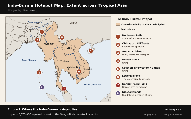
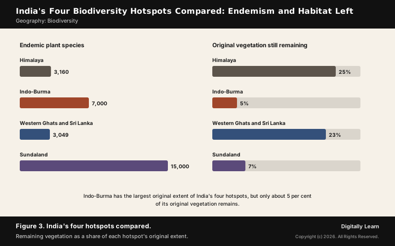
The Indo-Burma hotspot is a biodiversity hotspot of about 2.37 million square km in tropical Asia, east of the Ganga-Brahmaputra lowlands, running from north-east India and eastern Bangladesh across Myanmar, Thailand, Laos, Cambodia and Vietnam to southern China. In India it covers the north-east south of the Brahmaputra and the Andaman Islands. It holds about 7,000 endemic plant species, but only about 5 per cent of its original vegetation remains.
Indo-Burma Hotspot: Meaning, Extent and India's Share
What Is the Indo-Burma Hotspot? The Hotspot Criteria
A biodiversity hotspot is a region very rich in species, many of them found nowhere else, that is also losing its habitat fast. Under Norman Myers' criteria of 2000 a region qualifies only if it holds at least 1,500 endemic species of vascular plants and has lost at least 70 per cent of its primary vegetation; 36 regions qualify today. The Indo-Burma biodiversity hotspot is one of them.
- Why it qualifies: It has about 7,000 endemic plant species, far above the threshold, and only 118,653 of its original 2,373,057 square km of vegetation remains.
- India’s four hotspots: Himalaya, Indo-Burma, Western Ghats and Sri Lanka, and Sundaland.
- Older counts: Hotspots were first 25, then 34; three of them, Western Ghats and Sri Lanka, Indo-Burma and Himalaya, cover India’s richest regions, and Sundaland reaches India only in the Nicobar Islands.
The hotspot concept and all 36 hotspots are explained in the biodiversity hotspots article; the Indo-Burma region itself is set out below.
The Indo-Burma Region: Countries, Rivers and Boundaries
The Indo-Burma region covers 2,373,000 square km of tropical Asia east of the Ganga-Brahmaputra lowlands and contains the catchment of the Lower Mekong. It was once drawn to include the Himalaya and its foothills in Nepal, Bhutan and India, but has since been narrowed to the Indo-Chinese subregion, as the Indo-Burma hotspot map below shows.
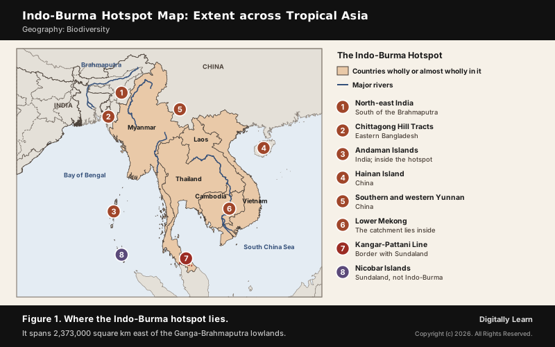
- Wholly or almost wholly inside: Laos, Cambodia and Vietnam, all of Myanmar except its northern tip, and most of Thailand except its southern tip.
- Partly inside: North-east India south of the Brahmaputra, the Chittagong Hill Tracts of eastern Bangladesh, southern and western Yunnan and the coastal lowlands of southern China, and a small part of Peninsular Malaysia.
- Islands: Hainan in the South China Sea and India’s Andaman Islands lie in Indo-Burma; the Nicobar Islands belong to the Sundaland hotspot.
- Southern boundary: The Kangar-Pattani Line across the Thailand-Malaysia border separates Indo-Burma from Sundaland.
- Ecoregions: 33 of them, from moist and dry broadleaf forests to coniferous, temperate broadleaf and mixed forests and mangroves.
The Nicobar Islands and the rest of Sundaland are covered in the Sundaland article, and the Himalaya hotspot in the Himalaya hotspot article.
Indo-Burma Region of India: North-East India and the Andamans
The Indo-Burma hotspot in India covers the north-east south of the Brahmaputra, together with the Andaman Islands. The Himalayan foothills north of the river were once counted in Indo-Burma but now fall in the Himalaya hotspot, so the river is the line to remember.
- Flowering plants: The north-east’s forests hold about 8,000 of India’s 15,000 species of flowering plants, and Arunachal Pradesh alone about 5,000.
- Endangered plants: About 800 of India’s 1,500 endangered plant species are reported from the north-east.
- Forest types: 51 of them, in six groups: tropical moist deciduous, tropical semi-evergreen, tropical wet evergreen, subtropical, temperate and alpine; six of India’s nine main vegetation types occur here.
- Forest cover: Most north-eastern states keep more than 60 per cent of their area under forest.
Biodiversity of the Indo-Burma Hotspot: Forests, Plants and Animals
Forests and Ecosystems of the Indo-Burma Hotspot
The monsoon sets the rhythm of these forests. In winter dry, cool winds from the Asian high bring a dry season under clear skies; in spring the winds reverse, and the south-west monsoon brings heavy rain as it rises over the hills.
- Forests: Mixed wet evergreen, dry evergreen, deciduous and montane forests.
- Special habitats: Shrublands on karst limestone, heath forests on some coasts, lowland floodplain swamps, mangroves and seasonally flooded grasslands.
- Rainforest at its northern limit: Namdapha National Park in Arunachal Pradesh holds the northernmost lowland evergreen rainforests in the world, at 27 degrees N, and extensive dipterocarp forests.
- Tall grasslands: Kaziranga’s wet alluvial grasslands cover nearly two-thirds of the park and are kept open by annual flooding and burning.
The tropical wet evergreen forests of the north-east and India's other forest types are explained in Indian Forest Types.
Indo-Burma Hotspot Plants: Citrus, Rice and Bamboo
About 7,000 plant species grow nowhere but in this hotspot, and north-east India is a cradle of crop plants. The Indian Council of Agricultural Research counts the region as a centre of rice germplasm, and it is rich in wild relatives of crop plants.
- Citrus: The genus Citrus evolved in the south-east foothills of the Himalayas, in a region stretching from eastern Assam through northern Myanmar to western Yunnan.
- Nokrek: The mother germplasm of Citrus indica, the wild Memang Narang, was found in the Nokrek range of Meghalaya’s Garo Hills, which led to a National Citrus Gene Sanctuary.
- Bamboo and mautam: Every 48 to 50 years the bamboo Melocanna baccifera flowers at once across Mizoram, Manipur, Tripura and parts of Assam; rats multiply on the seed, then eat stored grain, and a famine follows.
- Jhum crops: Traditional jhum farming by local tribes supported 35 varieties of crops.
Indo-Burma Hotspot Animals: Primates, Big Cats and Birds
The animal life of the hotspot is as rich as its plants. North-east India alone has 15 species of non-human primates, and the hotspot as a whole holds almost 1,300 bird species.
- Hoolock gibbon: India’s only ape, the second-largest of the gibbons; males are black with white brows and females grey-brown. The western hoolock gibbon is rated Endangered.
- Other primates: The stump-tailed, pig-tailed and rhesus macaques and the capped langur.
- Four big cats: Namdapha holds the tiger, leopard, snow leopard and clouded leopard.
- New mammals: Six large mammals have been discovered in the hotspot since the 1990s, among them the saola and the large-antlered muntjac.
- Threatened species: Eld’s deer, the fishing cat, the white-rumped vulture, the sarus crane and the Irrawaddy dolphin are among them.
The Brahmaputra as a Barrier: Hoolock Gibbon and Golden Langur
A great river can split the range of forest animals, and the Brahmaputra does exactly that. The hoolock gibbon and the stump-tailed macaque live south of it, in India's share of Indo-Burma, while the golden langur lives north of it.
| Primate | Where it lives in the north-east |
|---|---|
| Hoolock gibbon | South of the Brahmaputra, across all seven north-eastern states; also north and east of the Dibang |
| Stump-tailed macaque | South of the Brahmaputra, from Assam and Meghalaya to Mizoram and Tripura |
| Golden langur | North of the Brahmaputra, between the Manas and Sankosh rivers, into Bhutan |
- Golden langur’s range: About 30,000 square km bounded by the Brahmaputra to the south, the Manas to the east, the Sankosh to the west and Bhutan’s Black Mountains to the north.
- Numbers: Golden langurs in India rose from about 6,000 in 2008-09 to 7,396 in 2020-21.
- Gibbon sanctuary: Assam protects the gibbon at the Hollongapar Gibbon Sanctuary, which held 125 gibbons in 2023.
Indo-Burma Hotspot Species of the Wetlands: Rhino and Sangai
Floodplain swamps and flooded grasslands are among the hotspot's distinctive habitats, and north-east India has two famous examples. Kaziranga National Park, on the south bank of the Brahmaputra, is the single largest undisturbed area of the Brahmaputra Valley floodplain and the stronghold of the Indian rhinoceros.
- Rhino numbers: In 2022 there were 4,014 Indian rhinos, 3,262 of them in India; the species is Vulnerable. In 2008 Kaziranga held 2,613 of Assam’s 2,885.
- Kaziranga’s Big Five: Rhino, tiger, Asian elephant, wild water buffalo and swamp deer; it is a World Heritage Site, inscribed in 1985, and a tiger reserve.
- Loktak Lake: In Manipur, the biggest natural wetland of the north-east, known for its phumdis, floating mats of weeds covered with soil; a Ramsar site since 1990 and on the Montreux Record since 1993.
- Keibul Lamjao: The only floating national park in the world, 40 square km on Loktak’s largest phumdi, created for the sangai, Manipur’s brow-antlered deer.
India's Ramsar sites and the Montreux Record are explained in Ramsar Sites of India.
Protected Areas of the Indo-Burma Region in India
Protected Areas of North-East India: Map and Table
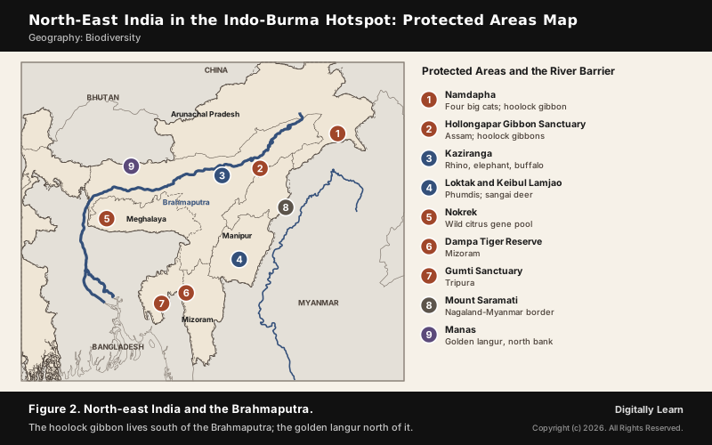
North-east India's parks protect the Indian share of the hotspot. Prelims has asked about them as matching pairs, testing the state and hill range of each.
| Protected area | State and setting | Known for |
|---|---|---|
| Namdapha | Arunachal Pradesh; between the Dapha Bum range of the Mishmi Hills and the Patkai range | Four big cats; 1,985 square km; a tiger reserve |
| Nokrek | Meghalaya; Garo Hills | Wild citrus; UNESCO biosphere reserve since 2009 |
| Loktak and Keibul Lamjao | Manipur; Bishnupur district | Phumdis; the sangai |
| Dampa | Mizoram; Lushai Hills | Largest sanctuary in Mizoram; tiger reserve since 1994 |
| Gumti | Tripura | Hoolock gibbon, capped and spectacled langurs |
| Kaziranga | Assam; Brahmaputra floodplain | Rhino and the Big Five |
- Mount Saramati: A peak on the border between Nagaland and Myanmar, forming a natural boundary between the two countries.
- Tiger reserves: Arunachal Pradesh has three tiger reserves, among them Namdapha; Assam has four, among them Kaziranga; Mizoram has one, Dampa.
Threats to the Indo-Burma Hotspot and Its Conservation
Threats to the Indo-Burma Hotspot: Farming, Plantations, Dams and Hunting
Indo-Burma is among the most threatened hotspots on Earth. Only 118,653 square km of its original 2,373,057 square km of vegetation remains, about 5 per cent, the smallest share of India's four hotspots.
- Fire and farming: This was one of the first places where people took up agriculture, with a long history of clearing land by fire; growing populations and markets have widened the clearing.
- Plantations: Teak, rubber and oil palm have replaced large areas of lowland forest, and coffee, tea, vegetables and sugarcane threaten the hill forests.
- Logging and mining: Timber, gems, ore, firewood and charcoal all take forest away.
- Dams and drained wetlands: A dam turns a river stretch into a large pond, cooling the water and cutting its oxygen, and floodplain swamps are drained for wet rice.
- Over-harvesting: Freshwater turtles, many found only here, are threatened by over-harvesting and habitat loss.
- Jhum and weeds in India: In the Garo Hills jhum and development have fragmented elephant habitat; at Loktak, water hyacinth has degraded the lake.
Conservation of the Indo-Burma Hotspot: Protection and Funding
Because the hotspots are too large to protect everywhere, conservation money is aimed at them. The Critical Ecosystem Partnership Fund has invested in Indo-Burma three times: USD 9.7 million for 2008-2013, USD 15.8 million for 2013-2020 and USD 10 million for 2020-2025.
- Protected land: 235,758 square km of the hotspot is protected, 132,283 square km of it in the stricter categories I to IV.
- Forest restoration: India’s National Afforestation Programme supports jhum site rehabilitation and horti-silviculture in the north-eastern states.
- Wetland protection: Loktak has a Loktak Development Authority, and Keibul Lamjao is on UNESCO’s tentative list as the Keibul Lamjao Conservation Area.
- Eco-sensitive zone: Namdapha was declared an eco-sensitive zone in 2024.
India's laws, missions and international conventions for biodiversity are explained in the article on India's biodiversity conservation framework.
Previous Year UPSC-CSE Questions
Previous Year UPSC-CSE Questions By the end you will be able to draft model answers for the following UPSC questions. Each question carries a collapsible framework showing how to approach it in the exam.
- UPSC Prelims 2014 Prelims-GSConsider the following pairs :
- Dampa Tiger Reserve : Mizoram
- Gumti Wildlife Sanctuary : Sikkim
- Saramati Peak : Nagaland
Which of the above pairs is/are correctly matched?
How to approach this Prelims question
Approach: Place each protected area or peak in its state. Dampa is in Mizoram, so pair 1 is correct. Gumti is in Tripura, not Sikkim, so pair 2 is wrong. Saramati is on the Nagaland-Myanmar border, so pair 3 is correct. Pairs 1 and 3 are correct.
Trap to watch: Gumti is in Tripura, not Sikkim.
Key facts to recall:
- (a) 1 only: wrong. Saramati Peak is in Nagaland, so pair 3 is also correct.
- (b) 2 and 3 only: wrong. Gumti Wildlife Sanctuary is in Tripura, not Sikkim.
- (c) 1 and 3 only: right. Dampa is in Mizoram and Saramati on the Nagaland-Myanmar border.
- (d) 1, 2 and 3: wrong. Pair 2 fails, because Gumti is in Tripura.
Answer signal: Answer (c), 1 and 3 only: Gumti lies in Tripura, which removes pair 2.
- UPSC Prelims 2013 Prelims-GSConsider the following pairs:
- Nokrek Biosphere Reserve : Garo Hills
- Loktak Lake : Barail Range
- Namdapha National Park : Dafla Hills
Which of the above pairs is/are correctly matched?
How to approach this Prelims question
Approach: Check the hill range, not only the state. Nokrek is in the Garo Hills, so pair 1 is correct. Loktak Lake is in Manipur, not the Barail Range, so pair 2 is wrong. Namdapha lies between the Mishmi Hills and the Patkai range, not the Dafla Hills, so pair 3 is wrong. Only pair 1 is correct.
Trap to watch: Namdapha lies between the Mishmi Hills and the Patkai range, not in the Dafla Hills.
Key facts to recall:
- (a) 1 only: right. Nokrek Biosphere Reserve is in the Garo Hills of Meghalaya.
- (b) 2 and 3 only: wrong. Loktak is not in the Barail Range and Namdapha is not in the Dafla Hills.
- (c) 1, 2 and 3: wrong. Pairs 2 and 3 are both mismatched.
- (d) None: wrong. Pair 1, Nokrek and the Garo Hills, is correct.
Answer signal: Answer (a), 1 only: Namdapha lies between the Mishmi Hills and the Patkai range, not the Dafla Hills.
- UPSC Prelims 2004 Prelims-GSConsider the following statements:
- Toothless mammals such as pangolins are not found in India.
- Gibbon is the only ape found in India.
Which of these statements given above is/are correct?
How to approach this Prelims question
Approach: Test each statement against what lives in India. The Indian pangolin is native to the subcontinent, so statement 1 is false. The hoolock gibbon is India's only ape, so statement 2 is true.
Trap to watch: The Indian pangolin is native to the subcontinent, so statement 1 is false.
Key facts to recall:
- (a) 1 only: wrong. Statement 1 is false; the Indian pangolin is native to the subcontinent.
- (b) 2 only: right. The hoolock gibbon is the only ape found in India.
- (c) Both 1 and 2: wrong. Statement 1 is false.
- (d) Neither 1 nor 2: wrong. Statement 2 is true.
Answer signal: Answer (b), 2 only: the gibbon is India's only ape, and pangolins do live in India.
Sources
- NCERT: Biology (Class XII), Biodiversity and Conservation
- MoEFCC: India's Fourth National Report to the Convention on Biological Diversity
- UNESCO World Heritage Centre: Kaziranga National Park
- National Tiger Conservation Authority: Tiger Reserves
- Ramsar Convention: Loktak Lake information sheet
- Wikipedia: Indo-Burma
- Wikipedia: Biodiversity hotspot
- Wikipedia: Northeast India
- Wikipedia: Hoolock gibbon
- Wikipedia: Gee's golden langur
- Wikipedia: Stump-tailed macaque
- Wikipedia: Namdapha National Park
- Wikipedia: Kaziranga National Park
- Wikipedia: Indian rhinoceros
- Wikipedia: Loktak Lake
- Wikipedia: Keibul Lamjao National Park
- Wikipedia: Nokrek National Park
- Wikipedia: Citrus
- Wikipedia: Mautam
- Wikipedia: Critical Ecosystem Partnership Fund
- UPSC: Civil Services Examination question papers
Disclaimer
This article draws on the NCERT textbooks, the Ministry of Environment, Forest and Climate Change, UNESCO, the National Tiger Conservation Authority, the Ramsar Convention and the other sources listed on this page. Hotspot boundaries differ between sources; the limits used here are stated in the text.