


Overview
The India State of Forest Report 2023, or ISFR 2023, is the national assessment of the country's forests, brought out by the Forest Survey of India under the Ministry of Environment, Forest and Climate Change. It is the eighteenth report in a biennial series that began in 1987, and it reads the forests from satellite imagery to measure how much of India is under tree cover and how that is changing. ISFR 2023 records the country's forest and tree cover at 8,27,357 square kilometres, which is 25.17 percent of the geographical area, of which forest cover alone is 7,15,343 square kilometres, or 21.76 percent. India's forests are estimated to hold about 7,285.5 million tonnes of carbon, and the mangroves cover 4,992 square kilometres. The report is also the subject of a long-running debate over how forest cover is defined and counted.
What the India State of Forest Report 2023 Records
The headline forest and tree cover figures for 2023
India has released its latest national stock-take of its forests. The India State of Forest Report 2023, the eighteenth in the series, is brought out by the Forest Survey of India under the Ministry of Environment, Forest and Climate Change, and it measures, from satellite imagery, how much of the country is under forest and tree cover and how that has changed.
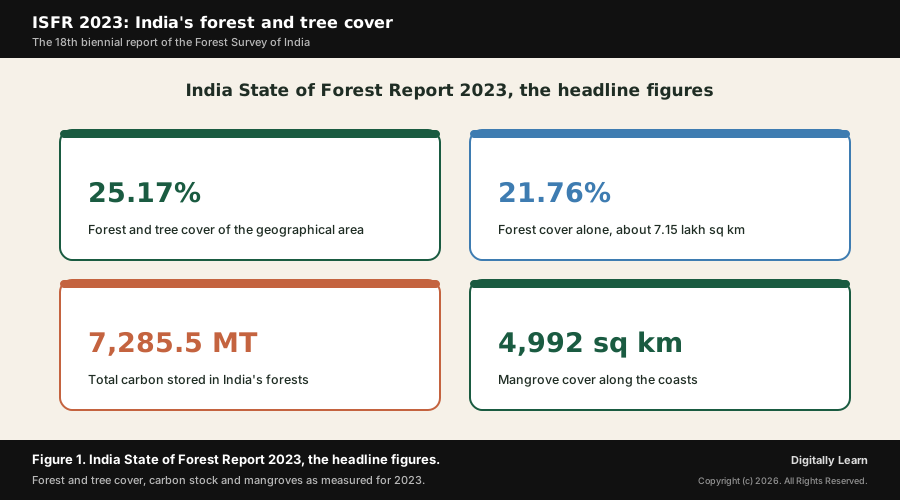
The report records the country's total forest and tree cover at 8,27,357 square kilometres, which is 25.17 percent of India's geographical area. Within this, the forest cover alone is 7,15,343 square kilometres, or 21.76 percent of the area, while the separately measured tree cover, the small patches and trees outside recorded forests, adds another 1,12,014 square kilometres, or 3.41 percent.
Beyond the area figures, ISFR 2023 estimates that India's forests hold about 7,285.5 million tonnes of carbon, and that the country's mangroves cover 4,992 square kilometres. Compared with the previous assessment of 2021, the forest and tree cover has risen by about 1,445 square kilometres. The figure below sets out the headline numbers.
Why the Forest Report Is in the News: A Rise and a Renewed Debate
A small net gain and the argument it has reopened
Why it matters now is that ISFR 2023 reports a modest national gain in forest and tree cover at a time of intense scrutiny of India's forests. The country's forest and tree cover rose by about 1,445 square kilometres over the 2021 figure, made up of a small 156 square kilometre rise in forest cover and a larger 1,289 square kilometre rise in tree cover, with Chhattisgarh, Uttar Pradesh, Odisha and Rajasthan showing the largest gains.
That headline rise has reopened a familiar debate. Critics argue that because the report counts every patch of dense canopy as forest cover, including plantations and orchards, a national increase can sit alongside the quiet loss of older natural forest, especially in the north-east, where several states recorded a fall. The report also notes a welcome decline in forest-fire hotspots, from about 2,23,333 in 2021-22 to 2,03,544 in 2023-24, which keeps the assessment in the news.
Understanding the Significance of the Forest Report
Why the forest stock-take matters for India
What is the significance of the forest report lies first in what it measures. ISFR 2023 is the country's only official, country-wide stock of its forests, and the figures it produces feed directly into India's planning for conservation, afforestation and the management of its protected areas, so the assessment shapes where money and effort are directed.
The deeper significance is for climate. The carbon held in India's forests is the basis of the country's pledge, under its climate commitments, to build an additional carbon sink, and the report measures progress towards that goal. A forest stock-take is therefore not only an environmental document but a key input to India's climate policy and to how the world judges the country's progress on its targets.
How Forest Cover Is Measured: Satellite Canopy Density and Forest Classes
The definition of forest cover and the use of satellite imagery
To read the report correctly, it helps to understand how the Forest Survey of India actually measures a forest. The assessment is done not by walking the land but by satellite remote sensing: images of the whole country are interpreted to see where the land carries a tree canopy, and that interpretation is then checked against field data.
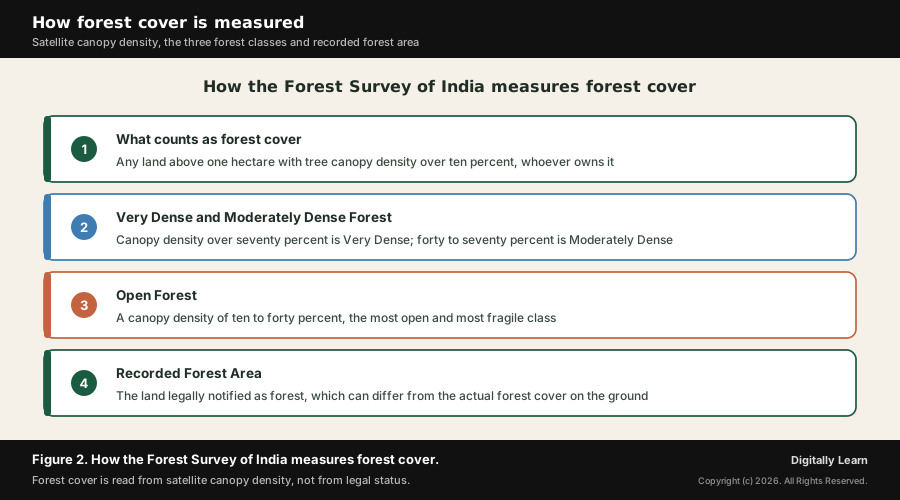
The key definition is precise and, as will be seen, contested. Forest cover is defined as all land more than one hectare in area with a tree canopy density of more than ten percent, irrespective of who owns the land or its legal status. This means that any sufficiently dense patch of trees counts, whether it is a natural forest, a government plantation, an orchard or trees on private or even urban land.
Because the definition rests on canopy density, the percentage of the ground shaded by the tree crowns, it can be applied uniformly across the country from imagery. The report separates this measured forest cover from the smaller patches and scattered trees outside recorded forests, which are counted as tree cover, so that the two together give the full forest and tree cover figure.
The three canopy-density classes and recorded forest area
Within the forest cover, the report sorts the land into three density classes, which matter because a denser forest stores more carbon and more biodiversity. Very Dense Forest has a canopy density of more than seventy percent; Moderately Dense Forest has a density of forty to seventy percent; and Open Forest has a density of ten to forty percent, the most fragile class and the one most easily degraded.
| Forest class | Canopy density | What it means |
|---|---|---|
| Very Dense Forest | More than 70 percent | The closest, most carbon-rich forest, often old natural forest |
| Moderately Dense Forest | 40 to 70 percent | Reasonably closed forest, the bulk of good forest cover |
| Open Forest | 10 to 40 percent | Sparse, fragile cover, easily degraded or lost |
A second key term is the Recorded Forest Area, the land that is legally notified as forest in government records, regardless of whether trees actually stand on it. The report deliberately separates the forest cover it sees from the satellite from this recorded forest area, because the two can differ: some recorded forest land carries little tree cover, while some real forest stands outside the legal boundary. The figure below sets out the method.
Key Findings in Detail: State Rankings, Mangroves and Carbon Stock
Which states have the most forest, by area and by share
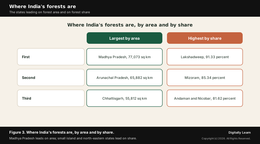
The report ranks the states in two different ways, and the two lists look very different. By sheer area of forest cover, the largest forests are in Madhya Pradesh, with 77,073 square kilometres, followed by Arunachal Pradesh with 65,882 square kilometres and Chhattisgarh with 55,812 square kilometres, the large central and north-eastern states that simply contain the most forested land.
Ranked instead by the share of their own area under forest, small island and hill territories lead. Lakshadweep has the highest forest cover as a proportion of its area at 91.33 percent, followed by Mizoram at 85.34 percent and the Andaman and Nicobar Islands at 81.62 percent. Reading the two rankings together shows that a state can hold a large forest yet have a small forest share, or the reverse. The figure below contrasts the two lists.
Mangroves, the carbon stock and the climate target
The report also measures the country's mangroves, the salt-tolerant coastal forests that buffer the shore against storms and cyclones. ISFR 2023 puts the total mangrove cover at 4,992 square kilometres, a small decrease of about seven square kilometres from 2021, even as some states such as Andhra Pradesh and Maharashtra recorded local gains, a reminder that the coastal forests remain under pressure.
Most important for climate is the carbon stock. ISFR 2023 estimates that India's forests and trees hold about 7,285.5 million tonnes of carbon, an increase of about 81.5 million tonnes since 2021. Expressed as carbon dioxide, this represents an additional carbon sink of about 2.29 billion tonnes against India's climate-pledge target of creating an extra sink of 2.5 to 3.0 billion tonnes of carbon dioxide equivalent by 2030.
The report further measures the country's growing stock, the total volume of wood standing in and outside the forests, and tracks the year's forest fires. The fall in fire hotspots, from about 2,23,333 in 2021-22 to 2,03,544 in 2023-24, is read as a sign of better fire management, though the fire season still scars large areas of open and dry forest each year.
Criticisms and Debates: Does the Forest-Cover Figure Overstate Forest Health
Why a rising forest-cover figure can hide a falling natural forest
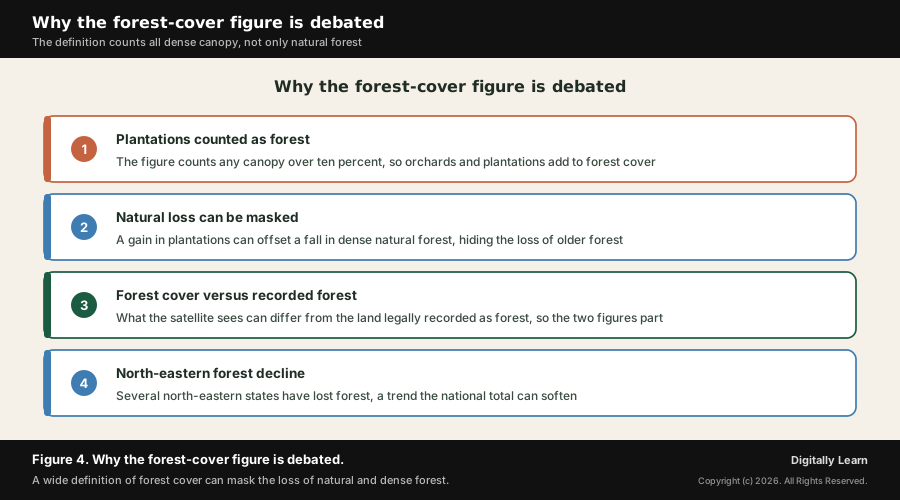
The most important debate around the report is not about the arithmetic but about the definition. Because forest cover counts any land with a canopy density above ten percent, irrespective of ownership or legal status, it treats a commercial plantation, an orchard, a coffee estate or even a patch of urban trees the same as old natural forest. A rise in such plantations can therefore lift the national figure even as natural, biodiversity-rich forest is lost.
This matters because the headline number can mask a real decline. A small national gain in forest cover may sit on top of the quiet loss of dense, old-growth forest in one region offset by new plantations in another, so the figure says little on its own about the health of the country's natural ecosystems. Critics argue that the report should distinguish more clearly between natural forest and man-made plantation.
A related concern is the gap between forest cover and recorded forest area. Because the satellite figure and the legal figure are measured differently, a place can be recorded as forest in law while carrying little tree cover, or carry trees that are not legally forest, which complicates both protection and accountability. The figure below sets out the main strands of the debate.
North-eastern forest loss and the methodology questions
A specific regional worry is the loss of forest in the north-east. Several north-eastern states, which hold some of India's richest and densest forests, have recorded a fall in forest cover across recent assessments, driven by shifting cultivation, development and felling. Because these states are small in area, their losses can be softened in the national total, so a country-wide gain can coexist with a regional decline that deserves attention in its own right.
There are also methodological questions, raised in good faith about a complex exercise. Changes in satellite sensors and interpretation methods between editions can affect comparability; the ten percent canopy threshold is low enough that very open, scrubby cover qualifies as forest; and area figures say nothing about forest quality, such as the loss of large old trees beneath a closed-looking canopy. None of this makes the report wrong, but it argues for reading the headline figure with care.
The Forest Report in Context: Climate Pledges, Green Missions and Forest Law
Where the report sits in India's environment framework
Contemporary linkages tie ISFR 2023 to the wider machinery of forest and climate governance in India. The carbon the report measures is the metric against which India tracks its pledge, made under the Paris Agreement through its nationally determined contributions, to create an additional carbon sink of 2.5 to 3.0 billion tonnes of carbon dioxide equivalent through forest and tree cover by 2030.
The report connects, too, to India's flagship greening programmes. The Green India Mission, one of the national missions on climate change, aims to increase forest and tree cover and to restore degraded land, and its progress is judged against the kind of figures ISFR produces. Afforestation is also funded through compensatory afforestation, the mechanism by which land diverted for projects must be made good by planting elsewhere, managed by a dedicated fund authority.
On the legal side, India's forests are governed by a framework that the report sits alongside. The Forest (Conservation) Act regulates the diversion of forest land for non-forest use, the Wildlife (Protection) Act underpins the protected areas, and the rights of forest-dwelling communities are recognised under the forest rights law, so the report's figures feed into decisions taken within this body of law and institutions.
Finally, the report links to the global conversation on forests, from the international reporting of forest area to the role of forests in absorbing carbon and sheltering biodiversity. India's forest figures are read internationally as part of how the country is judged on climate and on the protection of its rich natural heritage.
UPSC Relevance and Exam Focus
Where this fits in the UPSC-CSE syllabus
This topic maps to General Studies Paper III: conservation, environment and ecology, and to General Studies Paper I on the distribution of natural resources, with strong links to climate change and to India's environment reports and indices.
For Prelims, hold the high-yield facts: ISFR 2023 is the 18th report, brought out by the Forest Survey of India under the Ministry of Environment, Forest and Climate Change; forest and tree cover is 25.17 percent and forest cover 21.76 percent; the density classes are Very Dense, Moderately Dense and Open Forest; and forest cover is defined by a ten percent canopy threshold irrespective of legal status.
For Mains, the recurring framing is the status of India's forest resources and their impact on climate change, exactly the kind of question this report answers, and the critical evaluation of how forest cover is defined and counted. ISFR 2023 supplies both the data and the debate.
Recurring linked concepts an aspirant should keep in working memory:
- Forest cover versus recorded forest area: The satellite-measured tree canopy as against the land legally notified as forest, two figures that can differ.
- Canopy density classes: Very Dense, Moderately Dense and Open Forest, set by the share of ground under tree crowns.
- Forest carbon sink: The carbon stored in forests, the basis of India’s nationally determined contribution target for an additional sink by 2030.
- Compensatory afforestation: The principle that forest land diverted for projects must be offset by afforestation elsewhere, funded through a dedicated authority.
A common Prelims trap is to confuse forest cover with recorded forest area, or to carry forward the older 21.71 percent forest-cover figure of the 2021 report. The 2023 forest-cover figure is 21.76 percent, and it is measured from canopy density, not from legal records.
A common Mains trap is to read the rising headline figure as unqualified good news. Its real exam value lies in evaluating it critically: a wide definition that counts plantations as forest can mask the loss of natural forest, so the status of India's forests must be read alongside their quality and their regional distribution.
Previous Year UPSC-CSE Questions By the end you will be able to draft model answers for the following UPSC questions. Each question carries a collapsible framework showing how to approach it in the exam.
- UPSC Mains 2020 GS-IExamine the status of forest resources of India and its resultant impact on climate change.
How to structure the answer in the exam
Body (sub-themes to develop):
- Status of forest resources: forest and tree cover at 25.17 percent and forest cover at 21.76 percent of the geographical area, sorted into Very Dense, Moderately Dense and Open Forest, with a modest net gain over 2021.
- Distribution and quality: the largest forests by area in Madhya Pradesh, Arunachal Pradesh and Chhattisgarh, the highest shares in island and north-eastern territories, and continuing concern over the loss of dense natural forest, especially in the north-east.
- The measurement debate: because forest cover counts all canopy above ten percent, plantations and orchards can lift the figure while natural forest declines, so the status must be read with care.
- Impact on climate change: India's forests hold about 7,285.5 million tonnes of carbon, a growing sink that absorbs carbon dioxide and moderates warming, while mangroves and dense forest also buffer climate extremes.
- Climate commitments: the forest carbon sink is the basis of India's nationally determined contribution target of an additional 2.5 to 3.0 billion tonnes of carbon dioxide equivalent by 2030, pursued through the Green India Mission and compensatory afforestation.
Sources and Further Reading
- Forest Survey of India: State of Forest Report 2023
- Forest Survey of India: ISFR 2023 Volume 1
- Press Information Bureau: Union Minister Bhupender Yadav releases India State of Forest Report 2023
- Press Information Bureau: Forest and Tree Cover Grows, Fire Incidents Fall
- Ministry of Environment, Forest and Climate Change
- FAO: Global Forest Resources Assessment
- IUCN: Forests and forest restoration
- Space Applications Centre, ISRO: satellite remote sensing for resource assessment
- Wikipedia: Forest Survey of India
- Wikipedia: Forest cover by state in India
- Wikipedia: Green India Mission
Editorial Disclaimer
This briefing is for UPSC preparation. Verify the figures and findings against the official Forest Survey of India and PIB sources before relying on them.


