


Overview
Letter codes, the eight regions of India and Thornthwaite's moisture index
How climatologists turn temperature and rainfall into named climate types, and what those types look like on the map of India.

The Koppen climate classification sorts the world's climates into five main groups, A tropical, B dry, C warm temperate, D cold snow forest and E polar, using monthly temperature and rainfall, and adds small letters for the season of rain and the degree of heat. Applied to India, it gives eight climatic regions, from Amw on the Kerala coast to E in the Himalaya. Thornthwaite's scheme classifies climate instead by the balance between rain and evaporation.
Koppen Climate Classification: Meaning, Basis and History
What Is the Koppen Climate Classification?
The Koppen climate classification is a way of dividing the world's climates into a few named types, each defined by fixed values of temperature and precipitation. A climatic region is an area whose climate is roughly the same throughout because the same set of factors shapes it. Temperature and rainfall are the two elements that decide the class in every scheme of climatic classification.
Wladimir Koppen, a botanist by training, noticed a close relationship between the distribution of vegetation and climate. He chose values of temperature and precipitation that marked the edges of the main vegetation zones, and used them as the class boundaries. His main groups are therefore, in effect, vegetation types, which is why the scheme still helps to predict what will grow in a place.
- Empirical classification: Based on observed data, particularly temperature and precipitation; Koppen’s scheme is empirical, built on mean annual and mean monthly values.
- Genetic classification: Organises climates by their causes, such as air masses and winds.
- Applied classification: Made for a specific purpose, such as farming or building design.
History of the Koppen Scheme: From 1884 to Koppen-Geiger
The Koppen classification is the most widely used climate classification in the world. Wladimir Koppen (1846 to 1940) first published it in 1884 and reworked it several times, notably in 1918 and 1936. The German climatologist Rudolf Geiger changed it again in 1954 and 1961, so the modern version is often called the Koppen-Geiger classification.
Later schemes grew out of it. The Trewartha classification of 1966, revised in 1980, kept Koppen's tropical and polar groups but split the middle latitudes more finely, because Koppen's C group was too general. C. W. Thornthwaite began from Koppen's system in 1931 and then built a different one on the water budget, explained below.
Five Major Climate Groups and Koppen Letter Codes
Climate Groups A to E: Temperature and Rainfall Thresholds
Koppen recognised five major climatic groups, four based on temperature and one on precipitation. The capital letters A, C, D and E mark humid climates, and B marks dry climates. A sixth letter, H, is used for highlands, which are cold because of their height.
- A, Tropical: Every month averages 18 degrees C or more; the mean monthly temperature stays above 18 degrees C all year.
- B, Dry: Potential evaporation exceeds precipitation; rain is too low for the heat.
- C, Warm temperate: The coldest month averages between 18 degrees C and minus 3 degrees C (many modern maps use 0 degrees C as the lower line).
- D, Cold snow forest: The coldest month averages minus 3 degrees C or below, and the warmest month is above 10 degrees C.
- E, Polar: Every month averages below 10 degrees C.
- H, Highland: Climates that are cold because of elevation.
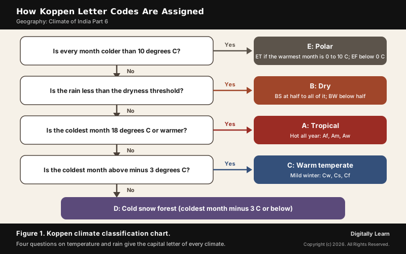
The dry group is defined differently from the others. A place is dry when its annual rain falls below a dryness threshold that rises with temperature, because a hot place loses more water to evaporation. If the rain is less than half the threshold, the climate is BW, desert; if it is between half and all of it, the climate is BS, steppe or semi-arid.
Koppen Small Letters: Season of Rain and Degree of Heat
Each group is split into types by small letters. The second letter says when the dry season falls, and a third letter says how hot or cold the place is. Reading a code is simply reading these letters in order: Cwg is a warm temperate climate (C) with a dry winter (w) of the Gangetic plain type (g).
| Letter | Meaning | Example code |
|---|---|---|
| f | No dry season; enough rain in every month | Af, Cfa, Cfb, Df |
| m | Monsoon: a rain forest climate despite a short dry season | Am, Amw |
| w | Dry season in winter | Aw, Cwa, Cwg, Dw |
| s | Dry season in summer | As, Cs |
| S and W | Semi-arid (steppe) and arid (desert), used only in group B | BS, BW |
| h and k | Hot, low-latitude dry climate; cold, mid-latitude dry climate | BWh, BSk |
| a, b, c, d | Degree of heat, from a hot summer (a) to a very severe winter (d) | Cfa, Cfb, Dfc |
| g | Gangetic plain type, used for India | Cwg |
| T and F | Tundra and ice cap in the polar group | ET, EF |
Tropical and Dry Climates: Af, Am, Aw, BS and BW
Tropical humid climates lie between the Tropic of Cancer and the Tropic of Capricorn. The sun is high all year and the Inter Tropical Convergence Zone keeps them hot and humid, with a small annual range of temperature and heavy rain.
- Tropical wet (Af): Near the equator in the Amazon Basin, western equatorial Africa and the East Indies. Rain falls in every month as afternoon thundershowers, days reach about 30 degrees C and nights about 20 degrees C, and there are no distinct seasons.
- Tropical monsoon (Am): The Indian subcontinent, north-eastern South America and northern Australia. Heavy rain falls mostly in summer, and winter is dry.
- Tropical wet and dry, or savanna (Aw): North and south of the Af belt, as in Brazil beyond the Amazon forest, Sudan and southern Central Africa. The wet season is short, the dry season long and the drought severe; deciduous forest and grassland with scattered trees grow here.
- Steppe and desert (BS and BW): From 15 to 60 degrees N and S. The hot subtropical types, BSh and BWh, lie at 15 to 35 degrees; the cold mid-latitude types, BSk and BWk, lie at 35 to 60 degrees in continental interiors.
The steppe gets slightly more rain than the desert, enough for sparse grassland, but its rain is highly variable. That variability hurts life in the steppe more than in the desert and has often caused famine. An extreme climate with scanty rain is also how the 2013 question describes the steppe of Central Asia, the land of nomadic herders.
Temperate, Cold and Polar Climates: Cfa, Cs, Cfb, D and E
Warm temperate climates lie between about 30 and 50 degrees of latitude, mainly on the east and west margins of the continents, with warm summers and mild winters. Where each one sits on the continent decides whether its rain comes in summer, in winter or all year.
| Climate and code | Rain, temperature and main areas |
|---|---|
| Humid subtropical, dry winter (Cwa) | Like savanna, but with a warm winter. North Indian plains and the interior plains of south China. |
| Humid subtropical (Cfa) | Rain all year, 75 to 150 cm; summer about 27 degrees C. Eastern USA, southern and eastern China, southern Japan. |
| Mediterranean (Cs) | Hot dry summer, mild rainy winter; 35 to 90 cm. Around the Mediterranean Sea, central California, central Chile. |
| Marine west coast (Cfb) | Rain all year, 50 to 250 cm; mild summer and winter. North-western Europe, New Zealand, southern Chile. |
| Cold, humid winter (Df) | Cold snowy winter, short frost-free season. Continental interiors at 40 to 70 degrees N. |
| Cold, dry winter (Dw) | Very cold dry winter, summer rain. North-eastern Asia. |
| Tundra (ET) and ice cap (EF) | Warmest month 0 to 10 degrees C, or below 0 all year. Arctic coasts; interior Greenland and Antarctica. |
The Mediterranean climate is the classic dry-summer type: the subtropical high sits over it in summer and the westerlies bring rain in winter. The marine west coast climate is its opposite in rhythm, with moderate temperatures and rain in every season because of the sea. The humid subtropical Cfa climate of southern and eastern China, which the 2002 question calls the China type, also has rain throughout the year, from summer thunderstorms and winter fronts.
- Tundra (ET): Named after its mosses, lichens and low flowering plants; the subsoil is permanently frozen (permafrost).
- Ice cap (EF): Interior Greenland and Antarctica, below freezing even in summer.
- Highland (H): Temperature changes sharply over short distances, giving a vertical zonation of climatic types with height; this is why tropical highlands carry several climates one above another.
Koppen Climate Classification of India: Eight Climatic Regions
How Many Climatic Regions Does India Have Under Koppen?
India has eight climatic regions under Koppen's scheme. The climatic regions in India all share a monsoon type of climate, but temperature and rainfall combine differently from region to region, and these differences are the sub-types of the monsoon climate. Koppen's letters, with the small letters f, m, w, h, c and g, turn them into eight codes, set out in NCERT's Table 4.1.
| Code and full form | Type of climate | Areas |
|---|---|---|
| Amw | Monsoon with a short dry season | West coast of India south of Goa |
| As | Monsoon with a dry summer | Coromandel coast of Tamil Nadu |
| Aw | Tropical savanna | Most of the Peninsular plateaus, south of the Tropic of Cancer |
| BShw | Semi-arid steppe | North-western Gujarat, parts of western Rajasthan and Punjab |
| BWhw | Hot desert | Extreme western Rajasthan |
| Cwg | Monsoon with a dry winter | Ganga plain, eastern Rajasthan, northern Madhya Pradesh, most of the North-east |
| Dfc | Cold humid winter with a short summer | Arunachal Pradesh |
| E | Polar type | Jammu and Kashmir, Himachal Pradesh and Uttarakhand |

Tropical Regions of India: Amw, As and Aw Climate
The three tropical codes cover the Peninsula, where no month averages below 18 degrees C. What separates them is how long the dry season is and when it comes.
- Amw, monsoon with a short dry season: The west coast south of Goa, where the south-west monsoon strikes the Western Ghats head on. The tropical monsoon strip along the Malabar coast and the Western Ghats usually gets more than 2,000 mm a year, enough to keep forests green through the short dry months of December to March.
- As, monsoon with a dry summer: The Coromandel coast of Tamil Nadu, the one part of India whose dry season falls in summer. The coast lies in the rain shadow of the Western Ghats during the south-west monsoon, and gets its main rain in October and November from the retreating and north-east monsoon.
- Aw, tropical savanna: Most of the Peninsular plateaus south of the Tropic of Cancer. The rains last from June to September, averaging 750 to 1,500 mm, and the long, hot dry season lets heat waves build in May.
Dry Regions of India: BShw Semi-Arid Steppe and BWhw Hot Desert
The north-west is the only part of India in Koppen's dry group, because there evaporation takes more water than the rain supplies. Both codes carry h, for a hot, low-latitude dry climate, and w, for a dry winter.
- BShw, semi-arid steppe: North-western Gujarat, parts of western Rajasthan and south-western Punjab, a belt between the true desert and the humid plains. Rain is unreliable, and the natural cover is short, coarse grass.
- BWhw, hot desert: Extreme western Rajasthan, the heart of the Thar. Annual rain totals less than 300 mm and comes in a few bursts in July to September; one year may be wet and the next two dry. May and June average about 35 degrees C, with daily maxima that occasionally pass 50 degrees C.
The dry climate here has a clear cause: the north-west lies in the subtropical high-pressure belt, where sinking air gives little rain, and the Arabian Sea branch passes along the Aravallis, causing only scanty rain, the same reason the world's hot deserts sit at 20 to 30 degrees of latitude. The hot deserts of the world are explained separately.
Cwg, Dfc and E: Climate of the Ganga Plain and the Himalaya
North of the Tropic of Cancer, winters are cool enough to take India out of the tropical group. The Ganga plain falls in group C, and the Himalaya, rising through every belt of temperature, reaches groups D and E.
- Cwg, monsoon with a dry winter: The Ganga plain, eastern Rajasthan, northern Madhya Pradesh and most of the North-east. C is warm temperate, w a dry winter and g the Gangetic plain type. Most rain comes from the south-west monsoon, and the dry winter is broken only by the western disturbances, whose light rain is highly valuable for the rabi crops of the north.
- Dfc, cold humid winter with a short summer: Arunachal Pradesh, where the coldest month falls to minus 3 degrees C or below, there is no dry season (f), and fewer than four months are warmer than 10 degrees C (c).
- E, polar type: Jammu and Kashmir, Himachal Pradesh and Uttarakhand, at heights where every month averages below 10 degrees C.
Height, not latitude, makes these mountain climates. Temperature falls by about 6.5 degrees C for every 1,000 metres of height, so the Himalaya runs from nearly tropical in the foothills to tundra above the snow line. Above 6,000 metres all precipitation falls as snow. North of the main range, the trans-Himalayan belt of Ladakh is a cold desert, barren and wind-blown, because the mountains block the monsoon.
Thornthwaite Climate Classification: Moisture Index and Water Budget
Thornthwaite's 1931 Scheme: Precipitation and Temperature Efficiency
The Thornthwaite climate classification grew from a criticism of Koppen. The American climatologist C. W. Thornthwaite argued in 1931 that what matters to plants is not the raw amount of rain or heat but how effective it is: rain that evaporates at once does little, and warmth matters by how fast it makes plants grow.
- Precipitation effectiveness (P-E index): Compares precipitation with evaporation, so the same rain counts for more in a cool place than in a hot one.
- Temperature efficiency (T-E index): Measures warmth by its effect on plant growth, from zero at the poleward limit of the tundra to 128 at the poleward limit of the tropical rainforest.
He applied the scheme to the whole world using data from more than four thousand stations. The resulting map was more rational than Koppen's but complicated, and it never became popular; that is one reason Koppen's scheme remains the standard in textbooks.
Thornthwaite Moisture Index and Potential Evapotranspiration
Thornthwaite's revised scheme of 1948 is built on the water budget of the soil. Its key quantity is potential evapotranspiration, the water that evaporation from the ground and transpiration from plants would remove if water were always available. The moisture index compares this demand with the rain that actually falls: the lower the index, the drier the place.
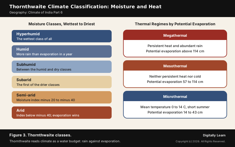
- Moisture classes: Hyperhumid, humid, subhumid, subarid, semi-arid (index minus 20 to minus 40) and arid (below minus 40). In humid regions precipitation exceeds evaporation over the year; in arid regions evaporation exceeds it.
- Thermal regimes: Megathermal, with persistent heat and potential evaporation above 114 cm; mesothermal, at 57 to 114 cm; and microthermal, with mean temperatures of 0 to 14 degrees C and 14 to 43 cm.
- The water balance: In 1955 Thornthwaite and J. R. Mather set out the water budget method, which estimates water surplus, runoff and the water that recharges an aquifer.
Because the moisture index measures the water actually available to plants, it is used in studies of crops, of the number of animal species an area supports, and of climate change. The United States Geological Survey still distributes a Thornthwaite monthly water-balance program as a research, assessment and classroom tool.
Thornthwaite Climate Classification of India and IMD's Aridity Index
Thornthwaite's 1948 scheme was applied to India in 1956, in a paper in Mausam, the India Meteorological Department's journal, using climatic data from about 250 stations. It showed two things earlier schemes had missed. Most of India is more arid than earlier maps suggested, and the country's heat is more than enough for forest everywhere, so what limits vegetation is the seasonal spread of the rain.
Seen this way, the Thar is a water-deficit region: over the year, evaporation there far exceeds the rain, which places western Rajasthan in the arid classes. The same logic explains why about a third of the Earth's land is arid or semi-arid.
The India Meteorological Department still uses Thornthwaite's idea of aridity, the water shortage a plant suffers, to watch for farm drought during the monsoon. Each week it runs a water balance for stations representing the country's agro-climatic zones.
- Water balance: Rain first meets the plants’ evapotranspiration; any excess recharges the soil to field capacity, and only then does the surplus run off.
- Aridity index: The water deficit, potential minus actual evapotranspiration, as a percentage of the potential; potential evapotranspiration is computed by Penman’s equation.
- Aridity anomaly: This week’s index minus the normal; an anomaly of 1 to 25 marks mild, 26 to 50 moderate and above 50 severe agricultural drought.
Difference Between Koppen and Thornthwaite Climate Classification
Both schemes use temperature and precipitation, but they ask different questions. Koppen asks whether a place crosses fixed values that match vegetation boundaries; Thornthwaite asks how much of the rain is actually available once evaporation is taken away.
| Basis | Koppen and Thornthwaite |
|---|---|
| Main idea | Koppen: vegetation boundaries match climate values. Thornthwaite: the water budget, rain against evaporation. |
| Key measure | Koppen: mean monthly temperature and precipitation. Thornthwaite: the moisture index built on potential water loss. |
| Output | Koppen: letter codes such as Aw, BWh and Cwg. Thornthwaite: moisture classes and thermal regimes. |
| Dates | Koppen: 1884, revised 1918 and 1936. Thornthwaite: 1931, revised 1948. |
| Strength | Koppen: simple, widely used, matches vegetation. Thornthwaite: measures the water really available to plants. |
| Weakness | Koppen: fixed temperature lines, water loss handled only roughly. Thornthwaite: complex; the world map never caught on. |
Uses of Climatic Classification: Trewartha, Agriculture and Climate Change
Trewartha Classification and the Middle-Latitude Problem
The Trewartha climate classification, published in 1966 and revised in 1980, is a modified Koppen scheme. It keeps the tropical and polar groups and redraws the middle latitudes by counting the months with a mean temperature of 10 degrees C or more.
- C, subtropical: Eight or more months at 10 degrees C or higher.
- D, temperate: Four to seven months at 10 degrees C or higher.
- E, boreal: One to three months at 10 degrees C or higher.
The change answers the main criticism of Koppen: a single C group that covers climates as different as the Mediterranean, the marine west coast and the monsoon-fed Ganga plain. Counting warm months separates them by the length of the growing season.
Climatic Regions, Monsoon Climate and Economic Life in India
India's climatic regions are the sub-types of one monsoon climate, and that shared monsoon is the axis of the farm year. About 64 per cent of Indians depend on agriculture, and agriculture itself depends on the south-west monsoon. Except in the Himalaya, temperatures stay above the level needed to grow crops all year.
- Crops by region: Regional differences in the monsoon climate let India grow many different crops, each suited to the heat and rain of its region.
- Winter rain: Rain from temperate cyclones in the north is highly beneficial for rabi crops.
- Hazards: Variability of rainfall brings drought or flood to some part of the country every year, and a sudden monsoon burst causes soil erosion over large areas.
- Ways of life: Regional variation in climate shows in India’s variety of food, clothes and house types.
Climatic classes are also a tool for watching climate change. Because each class matches a vegetation type, a shift of classes on the map signals a shift in what can grow. Between 1950 and 2010 about 5.7 per cent of the world's land moved from wetter and colder Koppen classes to drier and hotter ones. Projections to 2100 under a high-emission scenario show tropical climates spreading to higher latitudes, dry climates expanding and polar climates shrinking sharply.
Previous Year UPSC-CSE Questions
Previous Year UPSC-CSE Questions By the end you will be able to draft model answers for the following UPSC questions. Each question carries a collapsible framework showing how to approach it in the exam.
- UPSC Mains 2017 GS-IWhat characteristics can be assigned to a monsoon climate that succeeds in feeding more than 50 percent of the world population residing in Monsoon Asia?
How to structure the answer in the exam
Introduction: Define the monsoon climate as a tropical climate with a wet summer and a dry winter (Koppen Amw, Aw and Cwg in India), found over the Indian subcontinent and much of South and East Asia.
Body (sub-themes to develop):
- Rain in the hot season: warmth and water arrive together, ideal for rice.
- Regional sub-types (Amw, Aw, Cwg) let one country grow many crops.
- Temperatures above the growing threshold all year except in the mountains.
- Winter rain in the north from temperate cyclones supports a second crop.
- Variability: droughts, floods and soil erosion from sudden bursts.
Conclusion: Conclude that the seasonal rhythm of the monsoon makes Monsoon Asia productive, while its variability makes irrigation and forecasting essential.
- UPSC Prelims 2012 Prelims-GSWhich one of the following is the characteristic climate of the Tropical Savannah Region?
How to approach this Prelims question
Approach: Recall what w stands for in Aw: a dry season in winter, so the year splits into wet and dry.
Trap to watch: Rain throughout the year is Af, the tropical wet climate, not the savanna.
Key facts to recall:
- Aw lies north and south of the Af belt
- Wet season short, dry season long
Answer signal: A definite dry and wet season, option (d).
- UPSC Prelims 2002 Prelims-GSConsider the following statements:
- In equatorial regions, the year is divided into four main seasons
- In Mediterranean region, summer receives more rain
- In China type climate, rainfall occurs throughout the year
- Tropical highlands exhibit vertical zonation of different climates
Which of these statements are correct?
How to approach this Prelims question
Approach: Test each statement against the climate type it names.
Trap to watch: The Mediterranean climate gets its rain in winter, not summer.
Key facts to recall:
- Af: rain in every month, negligible annual range
- Cs: hot dry summer, mild rainy winter
- Highlands: vertical zonation with height
Answer signal: Statements 3 and 4, option (d).
- UPSC Prelims 2001 Prelims-GSThe temperature and rainfall of a meteorological station are given below: J F M A M J J A S O N D Temperature (°C): 9.4 10.6 11.7 12.2 13.3 13.9 13.9 14.4 15.6 15.0 13.3 10.6 Rainfall (cm): 12.2 9.1 7.9 2.5 1.8 0.3 – – 0.8 2.5 6.1 11.7 Average Temperature: 12.8 °C Average Rainfall: 54.9 cm per annum Identify the region having the above climatic pattern from amongst the following:
How to approach this Prelims question
Approach: Look at which months are wet: here the rain falls in winter and almost none in summer.
Trap to watch: A monsoon or steppe station would be wet in summer or dry all year.
Key facts to recall:
- Cs: winter rain from the westerlies, summer under the subtropical high
Answer signal: Winter rain, dry summer, 54.9 cm: Mediterranean region, option (a).
- UPSC Prelims 1999 Prelims-GSConsider the following temperature and rainfall data: Month Temperature °C Rainfall cm January 6.7 14.0 February 6.7 13.2 March 7.2 11.4 April 8.9 9.4 May 11.1 8.1 June 13.9 8.1 July 15.0 9.6 August 15.0 12.2 September 13.9 10.4 October 11.1 14.4 November 8.9 14.0 December 7.8 16.8 The climate to which this data pertains is
How to approach this Prelims question
Approach: Check the temperature range and the spread of rain across the year.
Trap to watch: China type is warmer (summer near 27 degrees C); Mediterranean has a dry summer.
Key facts to recall:
- Cfb: summer 15 to 20 degrees C, winter 4 to 10 degrees C, rain all year
Answer signal: Temperatures 6.7 to 15 degrees C with rain every month: West European type, option (c).
- UPSC Prelims 2013 Prelims-GS“Climate is extreme, rainfall is scanty and the people used to be nomadic herders.” The above statement best describes which of the following regions?
How to approach this Prelims question
Approach: Match extreme temperatures, scanty rain and nomadic herding to a mid-latitude steppe.
Trap to watch: Do not pick the savanna: it is tropical, with a definite wet season, not an extreme climate with scanty rain.
Key facts to recall:
- BSk: mid-latitude steppe at 35 to 60 degrees in continental interiors
Answer signal: Central Asian Steppe, option (b).
Sources
- NCERT: India Physical Environment (Class XI), Climate: Climatic Regions of India
- NCERT: Fundamentals of Physical Geography (Class XI), World Climate and Climate Change
- Wikipedia: Köppen climate classification
- Wikipedia: Climate classification
- Wikipedia: Climate of India
- Wikipedia: Charles Warren Thornthwaite
- Wikipedia: Trewartha climate classification
- IMD, Mausam 7(3), 1956: Climatic types of India according to the rational classification of Thornthwaite
- IMD Pune: Drought, Aridity Anomaly Index
- USGS Open-File Report 2007-1088: A monthly water-balance model (Thornthwaite)
- NOAA Science On a Sphere: Koppen-Geiger Climate Changes, 1901 to 2100
- UPSC: Civil Services Examination question papers
Disclaimer
This article draws on the NCERT geography textbooks and the other sources listed on this page. Climatic-region boundaries on the map follow district lines and are generalised.