


Overview
Natural vegetation and the Champion and Seth classification
What grows where in India's forests, and why.
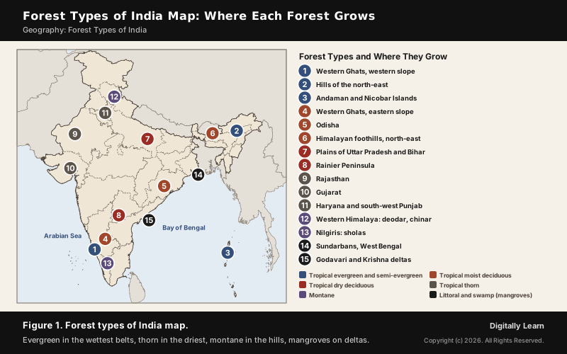
The forest types of India fall into five broad groups: tropical evergreen and semi-evergreen, tropical deciduous, tropical thorn, montane, and littoral and swamp forests. Rainfall, temperature, soil and altitude decide which grows where. The finer Champion and Seth classification divides India's forests into sixteen type groups.
Forest Types of India: Natural Vegetation and Its Controls
Natural Vegetation of India: What Decides the Forest Type
India has a great variety of natural vegetation, and it changes from one region to another with climate and soil. Temperate vegetation marks the Himalayan heights, tropical rain forests the Western Ghats and the Andaman and Nicobar Islands, mangroves the deltas, and thorny bushes the deserts of Rajasthan.
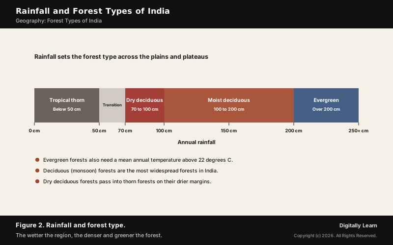
- Rainfall: The main control on the plains and plateaus, deciding whether a forest is evergreen, deciduous or thorn.
- Temperature: Evergreen forests need a mean annual temperature above 22 degrees C.
- Altitude: In the mountains, temperature falls with height, and the vegetation changes with it.
- Soil and topography: They shape the type too, as with the salt-tolerant mangroves of tidal mud flats.
How Many Types of Forest in India? Five Groups and Sixteen Type Groups
The answer depends on the scale. On the basis of the main vegetation and climatic region, Indian forests fall into five groups; foresters use a finer scheme of sixteen type groups.
- Five broad groups: The five types of forests in India are tropical evergreen and semi-evergreen, tropical deciduous, tropical thorn, montane, and littoral and swamp forests.
- Sixteen type groups: The Champion and Seth classification, taken up in detail below.
- Origin of the finer scheme: Harry George Champion published a classification of the forest types of India and Burma in 1936; S. K. Seth revised it in 1968.
The Five Main Forest Types of India
Tropical Evergreen and Semi-Evergreen Forests
Tropical evergreen forests grow where it is warm and very wet: more than 200 cm of rain a year and a mean temperature above 22 degrees C. They are found on the western slope of the Western Ghats, in the hills of the north-east and in the Andaman and Nicobar Islands.
- Structure: Well stratified, with shrubs and creepers near the ground, short trees above them and tall trees reaching 60 m or more.
- Always green: There is no fixed season for shedding leaves, flowering or fruiting, so the forest looks green all year.
- Trees: Rosewood, mahogany, aini and ebony.
- Semi-evergreen forests: In the less rainy parts of the same regions, a mix of evergreen and moist deciduous trees; white cedar, hollock and kail are the main species.
Tropical Deciduous and Thorn Forests: Monsoon Forests to Scrub
Tropical deciduous forests, the monsoon forests, are the most widespread forests in India. They grow where rainfall is 70 to 200 cm, and they shed their leaves in the dry season; by water supply they divide into moist and dry deciduous.
- Moist deciduous (100 to 200 cm): In the north-eastern states along the Himalayan foothills, on the eastern slopes of the Western Ghats and in Odisha; teak, sal, shisham, hurra, mahua, amla, semul, kusum and sandalwood.
- Dry deciduous (70 to 100 cm): Over vast areas, in the rainier parts of the Peninsula and the plains of Uttar Pradesh and Bihar; tendu, palas, amaltas, bel, khair and axlewood.
- Parkland: In the wetter parts of the Peninsular plateau and the northern plains, teak and other trees stand among open patches of grass.
- Transitions: On their wetter margins dry deciduous forests pass into moist deciduous, and on their drier margins into thorn forest.
Tropical thorn forests grow where rainfall is less than 50 cm. They are made of grasses and shrubs, and the plants stay leafless for most of the year, giving a look of scrub.
- Where: The semi-arid areas of south-west Punjab, Haryana, Rajasthan, Gujarat, Madhya Pradesh and Uttar Pradesh.
- Species: Babool, ber, wild date palm, khair, neem, khejri and palas.
- Undergrowth: Tussocky grass up to 2 m tall.
- Western Rajasthan: Vegetation is very scanty there because of low rainfall and overgrazing.
Montane Forests: Himalayan and Southern Mountain Forests
In the mountains the temperature falls with altitude, and the vegetation changes with it. Montane forests are of two kinds: the northern mountain forests of the Himalayas and the southern mountain forests of the Peninsula.
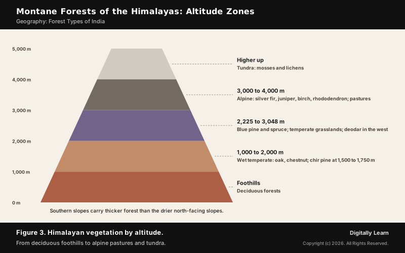
- Himalayan succession: Deciduous forests in the foothills, wet temperate forests of oak and chestnut at 1,000 to 2,000 m with chir pine at 1,500 to 1,750 m, blue pine and spruce at 2,225 to 3,048 m, and silver fir, juniper, birch and rhododendron at 3,000 to 4,000 m, then pastures and tundra.
- Valuable trees: Deodar grows mainly in the western Himalaya; the chinar and walnut support Kashmir’s handicrafts.
- Transhumance: The alpine pastures are grazed seasonally by the Gujjars, Bakarwals, Bhotiyas and Gaddis.
- Slope matters: Southern slopes carry thicker forest than the drier north-facing slopes.
- Sholas: In the Nilgiri, Anaimalai and Palani hills the temperate forests are called sholas, patches of stunted montane forest in valleys amid rolling grassland.
Forest soils of these hills are explained in Soils Part 6, the forest and mountain soils of India.
Littoral and Swamp Forests: Mangrove Forests in India
Mangroves grow along the coasts in salt marshes, tidal creeks, mud flats and estuaries. They are made of salt-tolerant plants, and their creeks of stagnant water and tidal flows shelter many birds.
- Extent: India’s mangrove cover is 4,992 square km (ISFR 2023).
- Where: Most developed in the Andaman and Nicobar Islands and the Sundarbans of West Bengal, and significant in the Mahanadi, Godavari and Krishna deltas.
- Sundarbans: The world’s largest mangrove forest, 10,277 square km across India and Bangladesh, 4,260 square km of it in West Bengal; sundri and gewa are its most abundant trees.
- Wetlands: India’s wetlands cover 3.9 million hectares, about 70 per cent of it under paddy.
Champion and Seth Classification of Forest Types of India
Champion and Seth Classification: The 16 Forest Type Groups
The Champion and Seth classification sorts India's forests into sixteen type groups by climate, soil, topography and altitude. It began with Harry George Champion's 1936 classification of the forests of India and Burma, which S. K. Seth revised in 1968.
| Type group | Where found |
|---|---|
| 1. Tropical wet evergreen | Western Ghats, Andaman and Nicobar Islands, the north-east |
| 2. Tropical semi-evergreen | Western Ghats, Andaman and Nicobar Islands, eastern Himalaya |
| 3. Tropical moist deciduous | Throughout India except the west and north-west |
| 4. Littoral and swamp | Andaman and Nicobar Islands, Ganga and Brahmaputra deltas |
| 5. Tropical dry deciduous | Northern India except the north-east; parts of the Peninsula |
| 6. Tropical thorn | Black-soil areas of north, west, central and south India |
| 7. Tropical dry evergreen | Coasts of Tamil Nadu, Andhra Pradesh and Karnataka |
| 8. Subtropical broadleaved hill | Eastern Himalaya and the Western Ghats (Silent Valley) |
| 9. Subtropical pine | Shivalik Hills, western and central Himalaya, Khasi, Naga and Manipur hills |
| 10. Subtropical dry evergreen | Shivalik Hills and Himalayan foothills up to 1,000 m |
| 11. Montane wet temperate | East of Nepal into Arunachal Pradesh; Nilgiris and high Kerala |
| 12. Himalayan moist temperate | Western to eastern Himalaya |
| 13. Himalayan dry temperate | Lahul, Kinnaur, Sikkim and other inner Himalaya |
| 14. Sub-alpine | Kashmir to Arunachal Pradesh, 2,900 to 3,500 m |
| 15. Moist alpine scrub | Along the Himalaya and high hills near Myanmar |
| 16. Dry alpine scrub | About 3,000 to 4,900 m |
Forest Types of India Map and Forest Cover
Forest Types of India Map: Where Each Forest Grows
The map brings the five groups together. The wettest belts, the Western Ghats and the north-east, carry evergreen forest; the driest north-west carries thorn forest; the deciduous forests fill most of the land between.
- Evergreen: Western slope of the Western Ghats, the north-eastern hills, the Andaman and Nicobar Islands.
- Deciduous: Himalayan foothills, eastern slopes of the Western Ghats, Odisha, the Peninsula and the plains of Uttar Pradesh and Bihar.
- Thorn: Rajasthan, Gujarat, Haryana and south-west Punjab.
- Montane and littoral: The Himalaya and the southern hills; the Sundarbans and the east-coast deltas.
| Forest type | Rainfall and setting | Typical trees |
|---|---|---|
| Tropical evergreen | Over 200 cm; warm and humid | Rosewood, mahogany, ebony |
| Moist deciduous | 100 to 200 cm | Teak, sal, shisham, sandalwood |
| Dry deciduous | 70 to 100 cm | Tendu, palas, amaltas, khair |
| Tropical thorn | Below 50 cm | Babool, ber, khejri, neem |
| Montane | Set by altitude | Oak, chir pine, deodar, fir |
| Littoral and swamp | Tidal coasts and deltas | Sundri, gewa |
Forest Cover in India: ISFR 2023 and State Rankings
The Forest Survey of India measures forest cover every two years in the India State of Forest Report, using satellite data and a field inventory. The ISFR 2023, the 18th report, puts forest and tree cover at 8,27,357 square km, 25.17 per cent of the country.
- Forest cover: 7,15,343 square km, 21.76 per cent; tree cover adds 1,12,014 square km, 3.41 per cent.
- Largest by area: Madhya Pradesh (77,073 square km), Arunachal Pradesh (65,882) and Chhattisgarh (55,812).
- Highest by share: Lakshadweep (91.33 per cent), Mizoram (85.34) and the Andaman and Nicobar Islands (81.62).
- Above a third: 19 states and union territories have more than 33 per cent of their area under forest, eight of them above 75 per cent.
- Change since 2021: Forest and tree cover rose by 1,445 square km, of which forest cover rose by 156.
The full ISFR 2023 findings, including carbon stock, are covered in India State of Forest Report 2023.
Mangrove Depletion and Forest Conservation Policy in India
Mangroves: Causes of Depletion and Importance for Coastal Ecology
Worldwide, mangroves are disappearing: at least 35 per cent have been lost, and the loss continues at 1 to 2 per cent a year. In India too the Sundarbans were assessed as endangered in 2020.
- Industry and settlement: Mangroves are cleared for industry, housing and tourism.
- Aquaculture: Shrimp farms, especially closed-pond systems that destroy much of the mangrove.
- Agriculture: Rice paddies, pasture and salt production.
- Less fresh water: Groundwater withdrawal and dams divert the fresh water mangroves depend on.
- Old pressure: The fertile delta soils of the Sundarbans region have been farmed for centuries, and most of the ecoregion is now under intensive agriculture.
Their value to the coast explains why the loss matters. The root systems dissipate wave energy and trap sediment, so mangroves build their own land and protect it.
- Shield: Mangrove swamps protect coasts from erosion, storm surges during cyclones, and tsunamis.
- Nursery: They shelter the young of fish and crustaceans, many of them commercially important.
- Carbon: Mangroves store large amounts of carbon, 4.19 gigatonnes worldwide in 2012.
- Water: They link land and sea ecosystems and keep coastal water clean.
How mangroves blunt cyclone storm surges is shown in Cyclones Part 9, on cyclone impacts.
Forest Conservation in India: Forest Policy, Laws and Missions
India adopted a forest policy in 1952 and revised it in 1988. The new policy stresses sustainable forest management: conserving and expanding forests while meeting the needs of local people.
- 1988 policy goals: Bring 33 per cent of the area under forest cover, restore ecological balance, conserve biodiversity, check soil erosion and desert spread, and involve people, including women, in planting.
- Social forestry: Urban, rural and farm forestry, classified by the National Commission on Agriculture in 1976, to manage forests and plant trees on barren land.
- Forest (Conservation) Act, 1980: The central government’s prior approval is needed to de-reserve forests or use forest land for non-forest purposes.
- 2023 amendment: It renamed the Act the Van (Sanrakshan Evam Samvardhan) Adhiniyam, 1980, added a preamble and exempted some land, such as strategic projects within 100 km of the borders.
- CAMPA Act, 2016: The Compensatory Afforestation Fund Act manages the money paid when forest land is diverted to other uses.
- Missions: The Green India Mission, launched in February 2014, expands forest cover through Joint Forest Management Committees; MISHTI (2023-2028) restores mangroves.
Previous Year UPSC-CSE Questions
Previous Year UPSC-CSE Questions By the end you will be able to draft model answers for the following UPSC questions. Each question carries a collapsible framework showing how to approach it in the exam.
- UPSC Prelims 2015 Prelims-GSConsider the following States:
- Arunachal Pradesh
- Himachal Pradesh
- Mizoram
In which of the above States do ‘Tropical Wet Evergreen Forests’ occur?
How to approach this Prelims question
Approach: Check each state against the regions where evergreen forests grow: Western Ghats, north-east, islands.
Trap to watch: Himachal Pradesh has montane, not tropical wet evergreen, forests.
Key facts to recall:
- Evergreen: over 200 cm of rain
- North-eastern hills carry evergreen forest
Answer signal: 1 and 3 only, option (c).
- UPSC Prelims 2015 Prelims-GSIn India, in which one of the following types of forests is teak a dominant tree species?
How to approach this Prelims question
Approach: Recall the main species of each forest type.
Trap to watch: Teak also grows in dry deciduous parkland, but it dominates the moist deciduous forests.
Key facts to recall:
- Moist deciduous: teak, sal, shisham
- Teak is a deciduous hardwood
Answer signal: Tropical moist deciduous forest, option (a).
- UPSC Mains 2019 GS-IDiscuss the causes of depletion of mangroves and explain their importance in maintaining coastal ecology.
How to structure the answer in the exam
Introduction: Open with what mangroves are and where they grow in India: 4,992 square km, the Sundarbans and the east-coast deltas.
Body (sub-themes to develop):
- Causes: industry, housing and tourism; shrimp aquaculture; agriculture and salt; diverted fresh water.
- Importance: shield against erosion, storm surge and tsunami; fish nursery; carbon store; clean water.
- Indian response: MISHTI (2023-2028) and the National Coastal Mission's mangrove component.
Conclusion: Conclude that protecting mangroves is cheaper coastal defence than rebuilding after cyclones, and that restoration needs local communities.
Sources
- NCERT: India Physical Environment (Class XI), Natural Vegetation
- PIB (MoEFCC): India State of Forest Report 2023 released, 21 December 2024
- PIB: India State of Forest Report 2023, explainer
- PIB (MoEFCC): Forest (Conservation) Amendment Bill 2023
- Forest Survey of India
- MoEFCC: India's Fourth National Report to the Convention on Biological Diversity
- Wikipedia: Harry George Champion
- Wikipedia: Sundarbans
- Wikipedia: Mangrove
- Wikipedia: Mangrove forest
- Wikipedia: Mangrove restoration
- Wikipedia: Shola
- Wikipedia: Tectona grandis
- Wikipedia: Forest Conservation Act, 1980
- Wikipedia: Compensatory Afforestation Fund Act, 2016
- UPSC: Civil Services Examination question papers
Disclaimer
This article draws on the NCERT geography textbooks, the Ministry of Environment, Forest and Climate Change through the Press Information Bureau, and the other sources listed on this page. Forest cover figures are from the latest India State of Forest Report.


