


Overview
Land and sea heating, the ITCZ, the Coriolis force and the jet streams
How the south-west monsoon forms, when it reaches each part of India, and what makes one season wetter or drier than another.
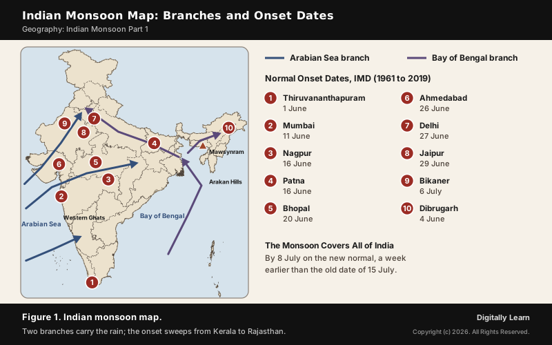
The Indian monsoon is the seasonal reversal of winds over the Indian subcontinent: moist south-west winds blow in from the Indian Ocean from June to September, and dry north-east winds blow out from the land in winter. The south-west monsoon brings about three-quarters of India's rain. It forms because the heated land draws the ITCZ, a belt of low pressure, north to 20 to 25 degrees N, where it is called the monsoon trough, and the south-east trades cross the equator and turn into south-westerlies.
Indian Monsoon: Meaning, Seasonal Wind Reversal and Monsoon Climate
What Is the Indian Monsoon?
The word monsoon comes from the Arabic mausim, which means season, and it refers to the seasonal reversal in the wind direction during a year. The Indian monsoon is exactly that: moist winds blow from the south-west, off the Indian Ocean, from June to September, and dry winds blow from the north-east, off the land, in winter.
The Indian monsoon season, June to September, is what India waits for. Over three-fourths of the country's rain falls in the south-west monsoon season, and for most parts of the country 70 to 90 per cent of the annual rainfall comes in these four months. The average annual rainfall of India is about 125 cm, but its spread is very uneven, from 12 cm to more than 250 cm a season. Over most of the country the monsoon lasts 100 to 120 days, from early June to mid-September.
- South-west monsoon: June to September; the rain-bearing season for most of India.
- Retreating monsoon: October and November, when the winds weaken and turn; the east coast of the Peninsula gets its rainiest months.
- North-east monsoon: The winter winds from the land, which bring rain to Tamil Nadu after picking up moisture over the Bay of Bengal.
- Two branches: The south-west monsoon reaches India as the Arabian Sea branch and the Bay of Bengal branch.
Monsoon Climate Characteristics and Monsoon Asia
India is part of a larger system. The major monsoon systems of the world are the West African, South Asian and Australian, North American and South American monsoons. The Asian monsoon has two sub-systems: the Indian subcontinental monsoon and the East Asian monsoon, which brings a warm, rainy summer and a cold, dry winter to China, Korea and Japan, where its rains are called Meiyu, Jangma and Bai-u.
Why India has a monsoon type of climate comes down to three features working together: a large landmass that heats quickly in summer, the warm Indian Ocean to its south that supplies moisture, and the Himalaya to the north, which blocks the cold air of Central Asia and holds the monsoon winds over the subcontinent.
- Seasonal rain: The rain falls between June and September, so there is a wet summer and a long dry season.
- Governed by relief: The windward side of the Western Ghats gets over 250 cm, and the north-eastern hills are among the wettest places.
- Declining away from the sea: Kolkata gets 119 cm in the south-west monsoon, Patna 105 cm, Allahabad 76 cm and Delhi 56 cm.
- Wet spells and breaks: Rain comes in spells of a few days separated by rainless breaks.
- Heavy downpours: Much of the rain runs off, causing soil erosion.
- Uncertain timing: The rains can start late or end early, damaging standing crops and delaying winter sowing.
Mechanism of Monsoon: Land and Sea Heating, ITCZ and Coriolis Force
Differential Heating of Land and Sea: The Thermal Concept
The mechanism of monsoon in India rests on four linked processes: differential heating of land and sea, the northward shift of the ITCZ, the turning of the winds by the Coriolis force, and the switch of the jet streams high above. Each is explained in turn below.
The oldest explanation treats the monsoon as a giant sea breeze. Towards the end of the nineteenth century, the differential heating of land and sea was taken to be the mechanism behind the monsoon winds. In April and May, when the sun shines vertically over the Tropic of Cancer, the large landmass north of the Indian Ocean heats intensely and an intense low pressure forms over north-west India. The ocean heats slowly and keeps higher pressure, so air flows from sea to land.
The difference comes from how each surface stores heat. Water has a heat capacity of 3.9 to 4.2 J per gram per degree and mixes its heat down to about 50 metres, while soil, sand and rock have only 0.19 to 0.35 and pass heat down by conduction alone. The land therefore warms and cools far faster than the sea. Over the arid north-west, this builds a heat low, a shallow trough reaching only about 1.5 km, over Pakistan and north-west India.
- Strong heat low: When pressure over the heat low is below normal, it acts as a suction device for moist air, which is linked to a good monsoon.
- Weak heat low: When pressure is above normal, rain is deficient over large areas; in 1987 pressure over the heat low stayed mostly above normal and the year was a drought year.
- The limit of the idea: No single theory explains the monsoon fully; heating is now treated as one factor, and the real breakthrough came when the monsoon was studied at the global level.
ITCZ and Indian Monsoon: The Monsoon Trough over the Ganga Plain
The global view centres on the Inter Tropical Convergence Zone (ITCZ), a low pressure belt near the equator where the trade winds of the two hemispheres meet and the air rises. It moves north and south with the sun. By the middle of July it lies between 20 and 25 degrees N, over the Gangetic plain, roughly parallel to the Himalaya, and there it is called the monsoon trough.
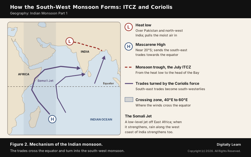
The Indian monsoon diagram in Figure 2 puts the pieces together: the heat low, the trough, the Mascarene High and the winds that cross the equator.
The monsoon trough is an elongated low running from the heat low over Pakistan to the head of the Bay of Bengal, over the Thar desert, Patna and the Chotanagpur plateau. Its eastern end swings north and south, and that swing sets the rhythm of the season. When the trough moves south, the monsoon is active over most of India; when it moves north to the foothills of the Himalaya, most of India gets a break while the foothills get heavy rain and the Brahmaputra may flood.
Coriolis Force and the South-West Monsoon Winds
A low pressure zone draws in winds from every side. When the ITCZ moves north, the south-east trade winds of the southern hemisphere are drawn across the equator towards it. They cross between 40 and 60 degrees E and are then deflected by the Coriolis force, which turns moving air to the right in the northern hemisphere, so they blow from south-west to north-east. The south-west monsoon is really a continuation of the south-east trades, deflected towards India after crossing the equator.
Two features of the southern Indian Ocean feed this flow. The Mascarene High, a high-pressure area around the Mascarene Islands east of Madagascar near 20 degrees S, pushes the air north; surges in its strength bring heavy rain to the west coast. The Somali jet, a low-level jet 1 to 1.5 km up that starts near Mauritius and northern Madagascar, runs along the East African coast, reaches the west coast of India in June and is strongest in July.
- Coriolis force and latitude: The deflection is greatest near the poles and zero at the equator; it acts to the left south of the equator and to the right north of it, so the south-east trades curve round to blow from the south-west once they cross.
- Coriolis force and speed: The force is proportional to the speed of the moving air, so faster winds are turned more strongly.
- Moisture on the way: Passing over the warm equatorial waters, the winds pick up moisture in abundance before they reach India.
Jet Streams, Tibetan Plateau and the Himalaya in the Monsoon Mechanism
Westerly Jet Stream in Winter and Its Withdrawal
High above the surface winds, at 9 to 13 km, a westerly jet stream blows from west to east over Western and Central Asia in winter. The Tibetan highlands stand in its path and split it in two: one branch passes north of the plateau, and the southern branch blows eastward south of the Himalaya, with its mean position at 25 degrees N in February.
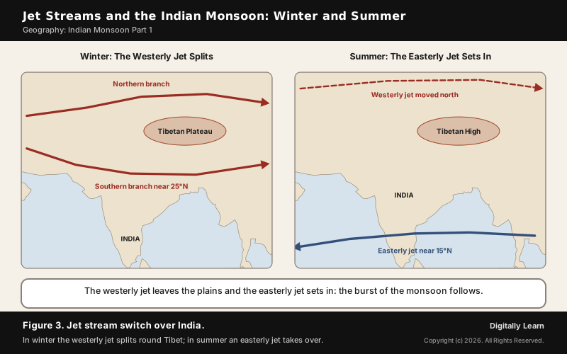
The southern branch shapes India's winter weather. It brings the western disturbances, shallow depressions from the Mediterranean, into north-west India, where they give winter rain on the plains and snow in the mountains (see western disturbances). In summer the jet must leave. Meteorologists have found a close link between the northward shift of the ITCZ and the withdrawal of the westerly jet from the North Indian Plain, and it is generally believed to be one of cause and effect.
The timing of that withdrawal matters. A timely northward shift of the subtropical westerly jet is critical to the onset; if the shift is delayed, so is the monsoon. Because the Himalaya holds the jet back, the shift is sudden rather than gradual, which helps explain why the rains burst rather than creep in.
Tropical Easterly Jet and the Tibetan High
Once the westerly jet has gone, an easterly jet stream sets in along 15 degrees N, and this easterly jet is held responsible for the burst of the monsoon in India. It flows over the southern Peninsula in June with a maximum speed of 90 km per hour, is confined to 15 degrees N in August and reaches 22 degrees N in September. It is called the tropical easterly jet and lies near 14 degrees N over the Peninsula in summer.
Its source is the heated plateau. In summer the Tibetan Plateau heats intensely, and a warm high-pressure system, the Tibetan High, forms over it in the upper troposphere. The air flowing out of this high to the south concentrates into the easterly jet, centred near the latitude of Chennai in July, which runs from the coast of Vietnam to the west coast of Africa.
- Steering the rain: The easterly jet steers tropical depressions into India, and the tracks of these depressions are the areas of highest rainfall.
- Strength of the season: A strong easterly jet goes with a strong monsoon over central India and a weak jet with a weak one.
- During breaks: The jet moves north to about 20 degrees N, and it weakens over India in September as the season ends.
Himalaya and Tibetan Plateau: Monsoon Barrier and Heat Source
The mountains do more than make rain fall on their slopes. The Himalaya confines the monsoon to the subcontinent: without it, the south-west winds would blow across India into Tibet, Afghanistan and Russia without causing much rain. It also shields northern India from the cold winds of Central Asia, and it forces the moist air to rise, so the foothills and the north-east get very heavy rain. Its rivers, the Indus, the Ganga and the Brahmaputra, brought down the alluvial deposits that form the northern plains.
The plateau behind the mountains is a heat engine. At more than 4,500 m on average, the Tibetan Plateau heats the air high in the atmosphere in summer and creates the Tibetan High that drives the easterly jet. The strengthening of the Asian monsoon has been linked to the uplift of the plateau after India collided with Asia around 50 million years ago.
Onset and Burst of the Monsoon, Its Two Branches and Withdrawal
Pre-Monsoon Showers and Local Storms of the Hot Season
Before the monsoon proper, the heat of April and May produces local storms. Moist air is drawn to the edge of the trough, and a sudden contact between dry and moist air masses gives violent winds, torrential rain and even hail. Each region has its own name for them, and the loo blows where the air stays dry.
- Mango showers: Pre-monsoon showers in Kerala and coastal Karnataka that help mangoes ripen early.
- Blossom showers: Showers that make coffee flowers blossom in Kerala and nearby areas.
- Nor’westers: Dreaded evening thunderstorms in Bengal and Assam, called Kalbaisakhi, a calamity of the month of Baisakh, and in Assam Bardoli Chheerha; they help tea, jute and rice.
- Loo: Hot, dry, oppressive winds over the northern plains from Punjab to Bihar, strongest between Delhi and Patna.
These storms belong to the hot season, before the monsoon winds set in. How pre-monsoon cyclones in the Bay and the Arabian Sea interact with the arriving monsoon is covered in cyclones and the Indian monsoon.
Onset over Kerala and the Burst of the Monsoon
By early June the low pressure over the north-western plains is strong enough to pull in the southern hemisphere trades. The rains then begin abruptly: this sudden onset of moisture-laden winds with violent thunder and lightning is called the burst of the monsoon. It may come in the first week of June on the coasts of Kerala, Karnataka, Goa and Maharashtra, and in the first week of July in the interior. Day temperatures fall by 5 to 8 degrees C between mid-June and mid-July.
The India Meteorological Department declares the onset over Kerala by a set of rules adopted in 2016. If, after 10 May, 60 per cent of 14 stations in Kerala and nearby report 2.5 mm of rain or more on two consecutive days, onset is declared on the second day, provided the winds and the clouds also match.
- Rainfall: At least 60 per cent of the 14 listed stations report 2.5 mm or more for two days running.
- Wind field: Westerly winds extend up to 600 hPa over the south-east Arabian Sea.
- Clouds: Satellite-measured outgoing longwave radiation is low, showing deep cloud.
Arabian Sea Branch and Bay of Bengal Branch
As the winds reach land, relief and the thermal low over north-west India bend them, and the monsoon arrives in two branches. The Arabian Sea branch splits into three streams; the Bay of Bengal branch is turned by the Arakan Hills of Myanmar and enters West Bengal and Bangladesh from the south and south-east instead of the south-west.
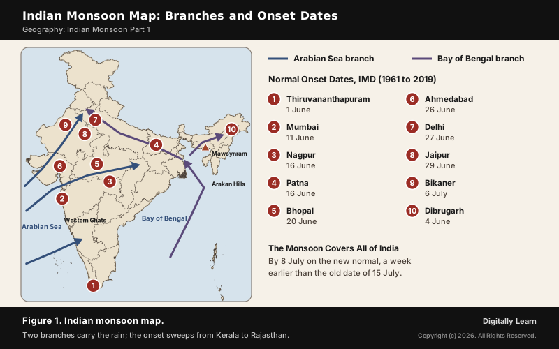
The Indian monsoon map in Figure 1 traces both branches and marks when the rains normally reach ten cities, from Thiruvananthapuram on 1 June to Bikaner on 6 July.
| Stream | Route | Result |
|---|---|---|
| Arabian Sea, first | Climbs the Western Ghats from 900 to 1,200 m | 250 to 400 cm on the windward side; a rain-shadow area east of the Ghats |
| Arabian Sea, second | Strikes the coast north of Mumbai; moves up the Narmada and Tapi valleys | Rain over central India; the Chotanagpur plateau gets 15 cm |
| Arabian Sea, third | Strikes Saurashtra and Kachchh; passes west Rajasthan along the Aravallis | Only scanty rain; joins the Bay branch in Punjab and Haryana |
| Bay of Bengal, first | Moves west along the Ganga plains | Reaches the Punjab plains |
| Bay of Bengal, second | Moves up the Brahmaputra valley; a sub-branch strikes the Garo and Khasi hills | Widespread rain; Mawsynram gets the highest average rainfall |
The Bay branch explains a Mains question. Over north Bengal and Bihar the monsoon winds are easterly or south-easterly, because this branch is moving west up the Ganga plains. In the Bhojpur region the rain-bearing wind therefore arrives from the east and is called Purvaiya, the easterly; its arrival opens the kharif season, when rice is sown. Tamil Nadu stays dry because its coast lies parallel to the Bay branch and in the rain shadow of the Arabian Sea branch.
Normal Dates of Onset and Withdrawal of the Monsoon
The monsoon sets in over the Kerala coast by 1 June and moves swiftly to reach Mumbai and Kolkata between 10 and 13 June; by mid-July it covers the whole subcontinent. Those were the old normals, based on 1901 to 1940. In 2020 the India Meteorological Department adopted new normal dates from 1961 to 2019 data: Kerala stays at 1 June, but the monsoon now covers the whole country by 8 July, a week earlier than the old 15 July.
| City | Old onset | New onset | Retreat |
|---|---|---|---|
| Kochi | 1 Jun | 1 Jun | No date |
| Mumbai | 10 Jun | 11 Jun | 8 Oct |
| Patna | 11 Jun | 16 Jun | 8 Oct |
| Bhopal | 13 Jun | 20 Jun | 3 Oct |
| Delhi | 29 Jun | 27 Jun | 25 Sep |
| Jaipur | 25 Jun | 29 Jun | 23 Sep |
| Bikaner | 8 Jul | 6 Jul | 18 Sep |
Withdrawal runs in reverse. The monsoon now starts to withdraw from north-west India around 17 September, more than two weeks later than the old date of 1 September, and retreats from most of the country by 15 October. So the season lasts more than four months in much of the south Peninsula but only about half that in the north-west.
Monsoon Depressions, Breaks and Variability: ENSO, IOD and MJO
Monsoon Depressions and the Break in the Monsoon
The rain itself comes from travelling systems. Monsoon lows and depressions, mostly formed at the head of the Bay of Bengal, are the principal rain-bearing systems of the season. On average two depressions form in each monsoon month; in July and August they usually form north of 18 degrees N and move west across the country. Their number, strength and paths decide where the rain falls, and their paths follow the monsoon trough.
If rain fails for one or more weeks after a few rainy days, it is called a break in the monsoon. Breaks have different causes in different regions.
- Northern India: Rain fails when rain-bearing storms along the monsoon trough over the region are not frequent.
- West coast: Dry spells come on days when the winds blow parallel to the coast instead of onto it.
- The trough shift: When the trough moves north to the Himalayan foothills, most of India gets a break while the foothills flood.
El Niño, Southern Oscillation and the Indian Ocean Dipole
From year to year, two ocean-atmosphere patterns matter most: the El Niño Southern Oscillation (ENSO) and the Indian Ocean Dipole (IOD). El Niño appears once every three to seven years, when a warm current replaces the cold Peruvian current and raises the sea temperature off Peru by 10 degrees C. It distorts the equatorial circulation, and in 1990-91 a strong El Niño delayed the onset over most of India by five to twelve days.
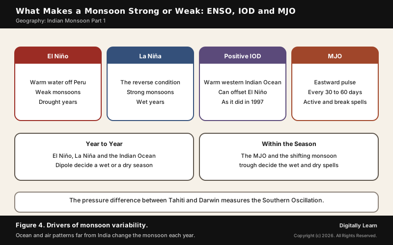
The atmospheric half of ENSO was found in India. Sir Gilbert Walker, Director General of Observatories in India, noticed the see-saw of pressure between Tahiti and Darwin, the Southern Oscillation, and linked it to India's rain: high pressure over Darwin meant poor rain. El Niño years tend to bring weak monsoons and droughts, and La Niña years strong ones. The full chain of effects on farms and prices is in ENSO and India.
ENSO is not the whole story. The strong El Niño of 1997 did not cause a drought in India. The reason, found in 1999, is the IOD, a see-saw of sea temperature between the western and eastern Indian Ocean. A positive IOD, with a warmer west, often cancels the effect of El Niño, as in 1983, 1994 and 1997; it builds from April to May and peaks in October.
Madden-Julian Oscillation and Active and Break Spells
Within a single season, the main driver of wet and dry spells is the Madden-Julian Oscillation (MJO), discovered by Madden and Julian in 1971. It is a pulse of enhanced and suppressed rain that travels east over the Indian and Pacific Oceans at about 4 to 8 metres a second, returning every 30 to 60 days. When its wet phase is over the Indian Ocean, the monsoon is active; when its dry phase arrives, rain is suppressed.
Other slower patterns also play a part, such as the North Atlantic Oscillation and the Pacific Decadal Oscillation, but ENSO and the IOD remain the main drivers from year to year. In 2025 the MJO was weak in June, stronger in July and August and weak again in September, giving intermittent support to the rain. How a warming climate may change these patterns is covered in Indian Monsoon Part 3.
Monsoon Forecasting in India: Rainfall Yardsticks and Forecast Systems
Long Period Average and Monsoon Rainfall Categories
A forecast needs a yardstick, and India's is the Long Period Average (LPA), the average rainfall over a long period such as 30 or 50 years. The LPA of the south-west monsoon for the country as a whole is 868.6 mm, the 1971 to 2020 average. Season rainfall within about 10 per cent of the LPA is normal for the country as a whole; below 90 per cent is below normal and above 110 per cent above normal. That is why the 108 per cent of 2025 still counted as a normal season.
| Category for a district or state | Rainfall against the LPA |
|---|---|
| Large excess | 60 per cent or more above |
| Excess | 20 to 59 per cent above |
| Normal | Within 19 per cent either way |
| Deficient | 20 to 59 per cent below |
| Large deficient | 60 to 99 per cent below |
Recent seasons show how close the forecasts now come. The forecast is counted accurate if it falls within 5 per cent of the LPA: in 2024 the forecast was 106 per cent and the actual 108 per cent, and the 2025 season also ended at 108 per cent of the LPA.
IMD Forecast Models and Mission Mausam
The India Meteorological Department has tried to forecast the monsoon since 1884 and is the only official agency for public monsoon forecasts. For years it forecast from 16 indicators, a sixteen-parameter model used from 1988 and replaced in 2003. Since 2021 it has combined its statistical system with a Multi-Model Ensemble of dynamical models.
The next step is Mission Mausam, approved by the Union Cabinet on 11 September 2024 with an outlay of Rs 2,000 crore over two years. The India Meteorological Department, the Indian Institute of Tropical Meteorology and the National Centre for Medium-Range Weather Forecasting will carry it out, with next-generation radars, satellites and supercomputers.
Previous Year UPSC-CSE Questions
Previous Year UPSC-CSE Questions By the end you will be able to draft model answers for the following UPSC questions. Each question carries a collapsible framework showing how to approach it in the exam.
- UPSC Mains 2017 GS-IWhat characteristics can be assigned to monsoon climate that succeeds in feeding more than 50 percent of the world population residing in Monsoon Asia?
How to structure the answer in the exam
Introduction: Define the monsoon as a seasonal reversal of winds and name the Asian systems: the Indian subcontinental monsoon and the East Asian monsoon.
Body (sub-themes to develop):
- Rain in the hot season: warm, wet summers suit rice and other kharif crops.
- Seasonal reversal: a wet season and a dry season give a fixed farming calendar.
- Large river plains watered by monsoon-fed rivers support dense settlement.
- Relief concentrates rain on the Western Ghats and the north-east; rain declines inland.
- Variability: late onset, breaks and early withdrawal bring droughts and floods.
Conclusion: Conclude that the monsoon's timing makes Monsoon Asia productive, while its variability makes forecasting and irrigation essential.
- UPSC Mains 2023 GS-IWhy is the South-West Monsoon called ‘Purvaiya’ (easterly) in Bhojpur Region? How has this directional seasonal wind system influenced the cultural ethos of the region?
How to structure the answer in the exam
Introduction: Open with the Bay of Bengal branch being turned by the Arakan Hills and moving west along the Ganga plains.
Body (sub-themes to develop):
- Over north Bengal and Bihar the monsoon winds are easterly or south-easterly, so in Bhojpur the south-west monsoon arrives from the east: Purvaiya.
- Its arrival opens the kharif season and rice sowing.
- The seasonal rhythm of the rains shapes the region's festivals, songs and farm calendar.
Conclusion: Conclude that the local name records the real path of the monsoon over the Ganga plains.
- UPSC Prelims 2010 Prelims-GSIf there were no Himalayan ranges, what would have been the most likely geographical impact on India?
- Much of the country would experience the cold waves from Siberia.
- Indo-Gangetic plain would be devoid of such extensive alluvial soils.
- The pattern of monsoon would be different from what it is at present.
Which of the statements given above is/are correct?
How to approach this Prelims question
Approach: Take each role of the Himalaya in turn: climate barrier, monsoon barrier, source of alluvium.
Trap to watch: All three statements hold; do not drop the alluvium statement as off-topic.
Key facts to recall:
- The Himalaya keeps out the cold winds of Central Asia
- It confines the south-west monsoon to the subcontinent
Answer signal: Statements 1, 2 and 3, option (d).
- UPSC Prelims 2024 Prelims-GSWith reference to “Coriolis force”, which of the following statements is/are correct ?
- It increases with increase in wind velocity.
- It is maximum at the poles and is absent at the equator. Select the answer using the code given below :
How to approach this Prelims question
Approach: Recall what the Coriolis force depends on: speed and latitude.
Trap to watch: It is zero at the equator, not maximum there.
Key facts to recall:
- Force proportional to the speed of the moving air
- Greatest near the poles, zero at the equator
Answer signal: Both statements, option (c).
- UPSC Prelims 2012 Prelims-GSConsider the following statements:
- The duration of the monsoon decreases from southern India to northern India.
- The amount of annual rainfall in the northern plains of India decreases from east to west.
Which of the statements given above is/are correct?
How to approach this Prelims question
Approach: Use the onset and withdrawal dates for duration, and the Ganga plain rainfall figures for the gradient.
Trap to watch: Both are true; the Bay of Bengal branch weakens as it moves west.
Key facts to recall:
- Onset 1 June in Kerala, 8 July for all of India; withdrawal from the north-west from 17 September
- Kolkata 119 cm, Patna 105 cm, Allahabad 76 cm, Delhi 56 cm
Answer signal: Both statements, option (c).
- UPSC Prelims 2017 Prelims-GSWith reference to ‘Indian Ocean Dipole (IOD)’, sometimes mentioned in the news while forecasting Indian monsoon, which of the following statements is/are correct?
- IOD phenomenon is characterised by a difference in sea surface temperature between tropical Western Indian Ocean and tropical Eastern Pacific Ocean.
- An IOD phenomenon can influence an El Niño’s impact on the monsoon.
Select the correct answer using the code given below:
How to approach this Prelims question
Approach: Check which two regions the dipole compares.
Trap to watch: The IOD compares the western and eastern Indian Ocean, not the Indian and Pacific Oceans.
Key facts to recall:
- A positive IOD offset El Niño in 1997
- It peaks in October
Answer signal: Statement 2 only, option (b).
- UPSC Prelims 2002 Prelims-GSFor short-term climate prediction, which one of the following events, detected in the last decade, is associated with occasional weak monsoon rains in the Indian sub-continent?
How to approach this Prelims question
Approach: Pick the event linked to weak monsoon rains.
Trap to watch: La Niña goes with strong monsoons.
Key facts to recall:
- El Niño every three to seven years
- Walker linked the Southern Oscillation to India's rain
Answer signal: El Niño and Southern Oscillations, option (c).
Sources
- NCERT: India Physical Environment (Class XI), Climate
- NCERT: Contemporary India I (Class IX), Climate
- NCERT: India People and Economy (Class XII), Land Resources and Agriculture
- IMD: New Normal Dates of Onset/Progress and Withdrawal of Southwest Monsoon over India (CRS Research Report 3/2020)
- IMD: Frequently Asked Questions on Monsoon
- IMD: Monsoon 2025, A Report
- PIB (Ministry of Earth Sciences): Cabinet approves Mission Mausam, 11 September 2024
- PIB: The Indian Monsoon, Nature's Pulse and Nation's Lifeline, 15 July 2025
- Wikipedia: Monsoon of South Asia
- Wikipedia: Monsoon
- Wikipedia: Intertropical Convergence Zone
- Wikipedia: Monsoon trough
- Wikipedia: Coriolis force
- Wikipedia: Somali Jet
- Wikipedia: Tibetan Plateau
- Wikipedia: Indian Ocean Dipole
- Wikipedia: Madden–Julian oscillation
- Wikipedia: Mawsynram
- UPSC: Civil Services Examination question papers
Disclaimer
This article draws on the NCERT geography textbooks, the India Meteorological Department, the Press Information Bureau and the other sources listed on this page. Onset dates are long-term normals; the monsoon of any single year arrives earlier or later.